In-depth exploration of the integration and innovation of cultural and tourism resources and the construction of a new consumption system is of profound significance for achieving high-quality development of the cultural and tourism industry, meeting people's aspirations for a better life, and promoting high-quality economic growth in China. By synthesizing diverse expert perspectives, several key issues emerge that require focused attention: (1) The integrated innovation of cultural and tourism resources provides a diverse product supply for new consumption, while new consumption guides the direction of innovation and value realization for cultural and tourism integration. A virtuous cycle mechanism has formed between the two, characterized by "consumption upgrading→resource integration→product innovation→industrial value addition". (2) Systematically advancing the deep alignment of integrated innovation in cultural and tourism resources with national strategies can not only cultivate new economic growth points but also provide important support for building a new dual-cycle development pattern. Future research should further deepen exploration across three dimensions: theoretical construction, evaluation systems, and practical focus. (3) While leveraging the positive role of digital technologies such as the metaverse in resource integration and product innovation, it is also necessary to guard against the potential risks of alienation that technological empowerment may bring. This requires a joint effort from the supply side's technological rationality and the demand side's conceptual education to collectively steer technology toward a human-centered and value-driven direction. Future research needs to construct a three-tier "macro-meso-micro" analytical framework to deeply investigate micro-level aspects such as individual consumer behavior characteristics and innovation practices of small and micro enterprises, thereby achieving a virtuous cycle between theoretical research and practical innovation.
In the era of artificial intelligence (AI), the integration of the digital economy and the real economy has been elevated to a new strategic level. Tourism, as an emerging strategic pillar industry, has become the forefront for the application of AI technology. In recent years, China has introduced a series of policies, further clarifying the application scenarios and governance models of AI in the tourism industry, providing important institutional guarantees for the digital and intelligent development of the tourism industry. At the same time, the national level has carried out the construction of new-generation information infrastructure represented by data centers and intelligent computing centers, promoting the accelerated circulation and value release of tourism data elements, and making the digital transformation of the tourism industry a reality. Integration of culture and tourism is an important national strategy. As a new production factor, AI constantly breaks down the boundaries of the cultural and tourism industries, reshapes the logic of tourism production and consumption, and accelerates the formation of new quality productive forces characterized by cross-border cooperation and scenario innovation, thereby promoting the development of integration of culture and tourism. However, problems such as data barriers and algorithm biases restrict the improvement of the efficiency and quality of integration of culture and tourism. This paper, based on the new era background, conducts in-depth discussions on the characteristics, real challenges, governance mechanisms and innovation paths of the era of AI empowering the high-quality development of integration of culture and tourism. The research findings are as follows: (1) AI empowering the high-quality development of integration of culture and tourism presents the characteristics of cross-scenario integration and diversified value creation; (2) The key points for the construction of the high-quality development system of integration of culture and tourism in the era of AI lie in factor integration, structural synergy and institutional innovation; (3) The core of the governance of integration of culture and tourism lies in building a data-driven collaborative community to achieve co-governance and sharing among multiple stakeholders. This paper not only helps to further deepen the theoretical connotation of integration of culture and tourism in the era of AI, but also provides useful references for scientific decision-making by relevant departments.
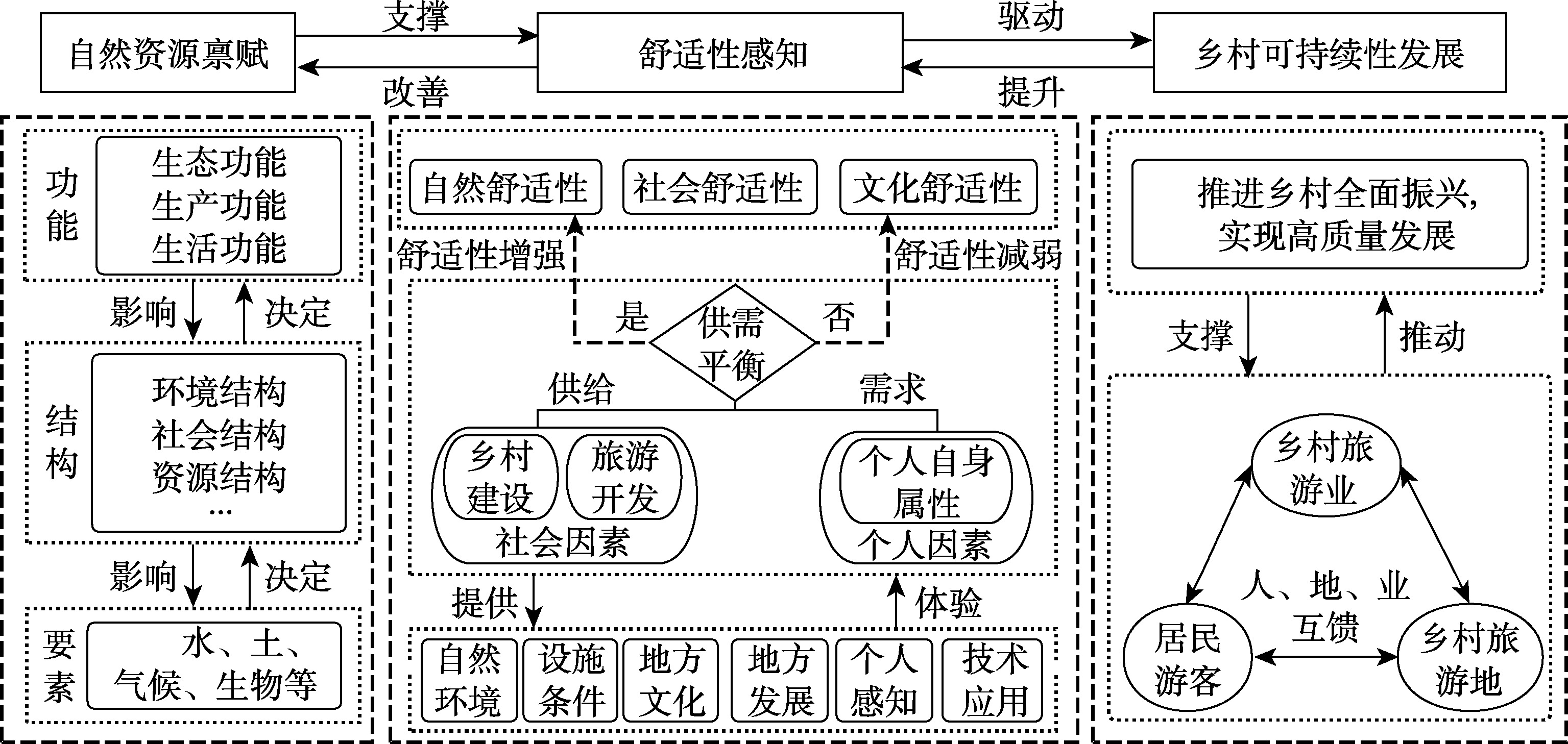
Enhancing amenity is a key pathway for rural tourism destinations to transform "lucid waters and lush mountains" into "invaluable assets", and an important component in promoting the construction of beautiful, livable, and prosperous villages. Based on the rural regional system theory, experience economy theory, and supply-demand theory, this paper constructs a theoretical framework of "natural resource endowment—amenity perception—rural sustainable development". Through empirical research on three typical case sites of different types in Jiangxi province, and by comprehensively applying exploratory and confirmatory factor analysis, the paper reveals the influencing mechanisms of amenity in rural tourism destinations and proposes improvement pathways accordingly. Key findings include: (1) Rural tourism destinations amenity is shaped by both objective factors (natural environment, facilities, local development, and culture) and subjective factors (personal perception, technology application), with the natural environment playing a core supporting role. (2) The formation of rural tourism destinations amenity is a dynamic process where three factors—foundational support, endogenous momentum, and exogenous momentum—interact to achieve a equilibrium through supply-demand interactions, reflecting the complexity and systemic nature of human-land relationships. (3) Enhancing rural tourism destinations amenity requires following the path of "element flow—structural optimization—functional manifestation". Through coordinated resource allocation, supply-demand optimization, and value realization, this approach drives rural areas toward high-quality living and tourism spaces. The study provides theoretical foundations and practical guidance for the sustainable development of rural tourism destinations.
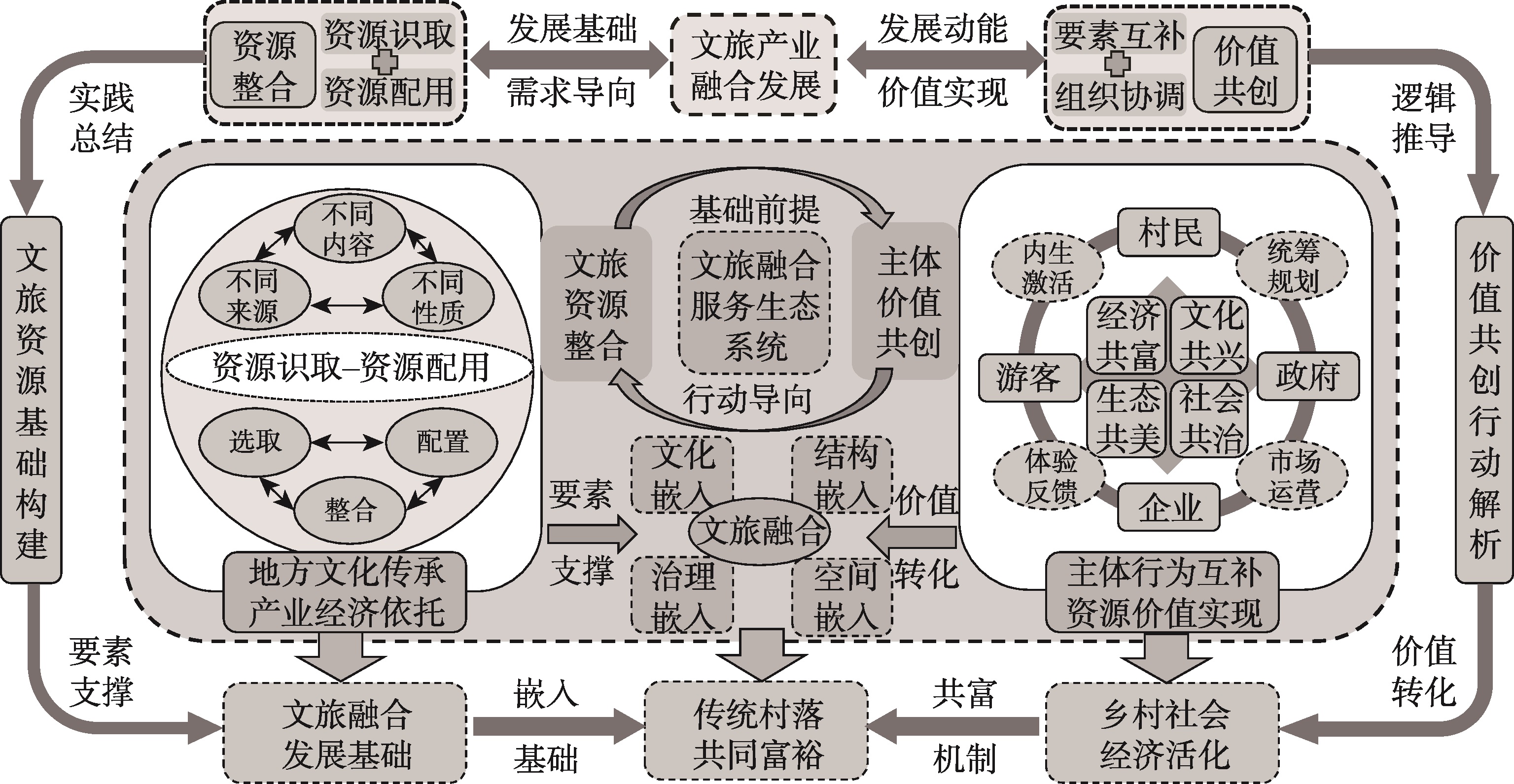
Traditional villages face challenges such as inefficient resource utilization and insufficient stakeholder coordination, which hinders the transformation of cultural and tourism value. Based on the theories of resource integration and value co-creation, this study takes the Goulan Yao village as a case to explore an embedded path for cultural and tourism integration to drive common prosperity. The findings reveal that: (1) Within the "resource integration-value co-creation-common prosperity" development framework, resource integration serves as the foundation for embedding cultural tourism, while common prosperity is the outcome of value co-creation, with the three elements progressing in a logical sequence. (2) The Yao village follows a "recognition-allocation-utilization" logic by deeply cultivating local cultural resources and incorporating modern elements, thereby achieving the industrial transformation of cultural tourism resources into economic capital. (3) The government, enterprises, villagers, and tourists engage in complementary actions and coupled elements within the value co-creation network, jointly fostering multi-dimensional value, including cultural, economic, and social benefits. This study reveals the intrinsic logic of cultural and tourism integration in traditional villages for common prosperity, enriches the theoretical framework of rural common prosperity, and provides both theoretical and practical references for the development of similar tourism-driven traditional villages.
The empowerment of ecological civilization construction by artificial intelligence has emerged as a pivotal pathway for advancing regional sustainable development. Drawing on the policies of Artificial Intelligence Innovation and Development Pilot Zones, this study employs the difference-in-differences method and utilizes panel data of 282 prefecture-level and above cities spanning the period from 2011 to 2023 to empirically investigate the mechanism through which artificial intelligence technology application influences the value transformation efficiency of ecological products. The key findings are summarized as follows: (1) The application of artificial intelligence technology exerts a significantly positive impact on the regional value transformation efficiency of ecological products, which is primarily mediated by strengthening public environmental attention, facilitating green technological innovation, enhancing ecological governance capacity, and driving industrial upgrading. (2) Heterogeneity analysis reveals the "compensation effect" of artificial intelligence application, namely, the promotional effect of artificial intelligence technology application is more pronounced in cities with relatively poor ecological environments. (3) In comparison with artificial intelligence innovation-driven development, the industrialization of artificial intelligence exerts a more significant facilitating effect on the value transformation efficiency, indicating that the commercial application of technology constitutes a critical link in realizing the effective transformation of ecological value.
This study examines the pathways to urban-rural common prosperity in key ecological function zones, using Guangdong's Wanlyu Lake Green Development Zone as a case area. Guided by the "two mountains" theory (lucid waters and lush mountains are invaluable assets), we developed an analytical framework integrating "production-living-ecological" functions. Employing a mixed-methods approach—combining entropy weighting, a coupling coordination degree model, and semi-structured interviews—we identified distinct prosperity models and their endogenous drivers. Key findings indicate that: (1) Significant spatial disparities in common prosperity levels across townships in 2023, characterized by a dominant urban core and a declining north-south gradient. (2) The coupling coordination of the three functions exhibits marked geographical heterogeneity, delineating three synergistic models: symbiotic harmony, synergistic value added, and development-livability. (3) These models represent distinct pathways to common prosperity, driven respectively by production-led livelihood sharing, eco-centric quality of life, and value conversion from ecological assets. (4) Endogenous dynamics are fueled by a triple-driver mechanism—resource transformation, factor circulation, and spatial restructuring—which synergistically enhances prosperity and fosters integrated urban-rural development. This research provides a systematic framework for understanding and promoting sustainable prosperity in ecologically constrained regions.
Exploring the evolutionary process of realizing the value of ecological products under collaboration between government and social organizations is crucial for advancing the transformation of "Two Mountains" and promoting coordinated regional development and common prosperity. Taking Qingshan village in Zhejiang province as a case study, this research systematically analyzes the evolution and endogenous logic of ecological product value realization under collaboration between government and social organizations based on actor-network theory. Findings reveal that: (1) Social organizations have transcended their traditional role as a supplementary role to government, and collaboration between government and social organizations effectively activates the endogenous driving force for realizing ecological product value. (2) The value realization process involves two stages: value manifestation and value deepening. The Nature Conservancy (TNC) plays a pivotal role, while the influence of local governments and social professionals within the network gradually increases, with the industrialization of ecology continuously releasing green dividends. (3) Qingshan village's ecological prosperity stems from the synergistic interplay of three logics: "ecology as foundation, power coordination, and benefit sharing". (4) Future efforts to further activate the endogenous vitality of ecological product value realization should focus on reshaping governance roles, deepening property rights reforms, implementing adaptive governance, and prioritizing shared benefit mechanisms.
The urban-rural integration in cross-border areas of metropolitan regions faces challenges stemming from mismatched endowment allocations and constrained cross-border factor flows. The flow space is playing an increasingly dominant role in resource allocation and spatial organization. Drawing upon the perspective of flow-form coupling, this study constructs an assessment framework to evaluate the performance of urban-rural integration networks, encompassing three core modules: identification of urban and rural endowments, construction of functional-spatial connection networks, and spatial pattern performance assessment. An empirical analysis is conducted in the Changsha-Zhuzhou-Xiangtan green heart area (CZTGHA). The findings reveal the following: (1) The precise functional complementarity and free exchange of elements constitute the two most critical relational mechanisms driving urban-rural integration in cross-border regions of metropolitan areas, giving rise to a flow-form dual structure encompassing both functional linkages and spatial configurations. The coordinated evolution and deep coupling of these mechanisms fundamentally shape the spatial performance of urban-rural integration. (2) Urban endowments exhibit a pronounced multi-polar and networked development trend, whereas rural endowments have experienced significant decline in peri-urban zones and along regional development corridors, with a tendency toward homogenized development paths. (3) Urban-rural spatial linkages in the study area are characterized by imbalance, and cross-border functional interactions between urban and rural areas face administrative boundary constraints, presenting a core-periphery pattern. (4) The performance of urban-rural integration in the CZTGHA is markedly higher than that observed in peripheral rural units. In 2024, 64% of spatial units in the study area were constrained by weak spatial linkages, while 52% suffered from inadequate functional connections. Flow-form mismatch constitutes a fundamental cause underlying the low urban-rural integration performance in these marginal areas. This research contributes theoretically to enriching the understanding of the inherent laws governing urban-rural integration, as well as provides epistemological and methodological references for the territorial spatial governance of metropolitan areas.
Rural differentiated transformation is a critical driver of common prosperity yet faces challenges in resource conversion and equitable benefit sharing. Integrating the "Lucid waters and lush mountains are invaluable assets" (hereafter referred to as the "two-mountains" concept) with a transaction cost perspective, this study examines how government-market synergy activates resource conversion. Drawing on the dynamic cyclical logic of the social-ecological systems framework, we construct an analytical framework comprising four dimensions, which included resource endowment, actor collaboration, conversion pathways and common prosperity effects, emphasizing their dynamic interactions. Empirical analysis of three suburban villages in Huzhou, Zhejiang, yields three key findings: (1) Transformation outcomes depend on rationally matching resource social embeddedness with governance structures. Low, medium, and high embeddedness generate distinct transaction costs (investment risks, coordination costs, and supervision costs), necessitating hierarchical, hybrid, and relational market governance, respectively. (2) Benefit distribution patterns are dictated by the governance structure's internal interest-linkage mechanisms. Loose, semi-loose, and tight linkages lead to trickle-down effects, disjointed sharing, and inclusive sharing, respectively, revealing the institutional trade-off between efficiency and equity. (3) Sustainable transformation relies on dynamic governance adaptation. Systems must calibrate governance boundaries and interest linkages based on feedback to mitigate endogenous risks and break negative path dependence. Theoretically, this study offers a micro-mechanism framework for rural transformation. It reframes the macro issue of government-market boundaries into a contextual, dynamic design problem, providing guidance for differentiated strategies to achieve common prosperity.
In poverty-alleviated areas, the endogenous development momentum and the self-development ability of the poverty-alleviated people are limited, and there is a relatively high risk of large-scale return to poverty. Taking Y ethnic village in Yunnan province as an example, this paper constructs an analytical framework for achieving pre-event prevention of large-scale return to poverty through new endogenous development based on the actor-network theory. The study finds that due to the existence of multi-dimensional internal vulnerabilities, ethnic villages have shifted to the "blood-making" new endogenous development driven by industries. By constructing four-dimensional empowerment mechanisms of politics, ideology, interests, and talents, it has laid the institutional, ideological, economic, and subject foundations for pre-event prevention of large-scale return to poverty and realized the collaborative prevention of multiple subjects. Thus, the coordination effect based on the network coordinates internal and external forces to enhance the endogenous development momentum of the village, the diffusion effect based on the network improves the villagers' self-development ability through aspiration-boosting and intelligence-enhancing education, and the sharing effect realized by the interest-linking mechanism ensures the inclusiveness of new endogenous development, ultimately achieving pre-event prevention of large-scale return to poverty. This paper reveals the theoretical logic of realizing the new endogenous development of ethnic villages by reconstructing the actor network, extracts the practical logic of preventing the risk of large-scale return to poverty through new endogenous development, and hopes to provide empirical reference for poverty-alleviated villages to prevent large-scale return to poverty.
Regions rich in forest resources in China have long faced a development dilemma characterized by abundant ecological endowments but relatively weak economic performance. Alleviating the forest "resource curse" is therefore crucial for promoting balanced and coordinated regional development. Using provincial panel data from 2011 to 2023, this paper first measures the annual digital economy development index and the forest "resource curse" coefficient for each region, and then constructs two-way fixed effects, mediation effects and spatial Durbin models to empirically examine the direct, mediating and spatial spillover effects of the digital economy on the forest "resource curse". The main findings are as follows: (1) The digital economy significantly mitigates the forest "resource curse", with increasing marginal returns as the curse deepens, indicating that regions facing more pronounced "resource curse" problems gain relatively larger benefits from digital development. Its three dimensions—digital infrastructure, digital industrialization and industrial digitalization—all contribute to weakening the forest "resource curse" and unlocking the development potential of forest-rich regions. (2) The digital economy reduces the forest "resource curse" through three key transmission channels, namely by promoting the value realization of forest ecological products, driving technological innovation in forestry, and improving forestry human capital. (3) When the digital economy is decomposed into its core dimensions, industrial digitalization exerts a more pronounced mitigating effect on the forest "resource curse" than digital infrastructure construction and digital industrialization. Furthermore, the capacity of the digital economy to alleviate the forest "resource curse" is found to be noticeably stronger in the central region of China than in the eastern and western regions, thereby revealing a distinct pattern of regional heterogeneity in its impact. (4) The digital economy also shows a pronounced spatial spillover effect in alleviating the forest "resource curse", with its mitigation impact transmitted to geographically adjacent provinces through spatial linkages exceeding the direct alleviation effect observed within the province itself. Overall, the findings provide empirical evidence on how the digital economy reshapes the development path of forest-rich regions and offer useful policy implications for exploring coordinated pathways to reconcile ecological conservation with economic development amid rapid digital transformation.
In the context of China’s deepening education reform and the ongoing advancement of ecological civilization, nature study education has emerged as a crucial platform that bridges formal schooling with ecological practice. However, existing research and practice in this field remain fragmented and experience-driven, lacking a systematic theoretical framework that integrates educational and ecological dimensions. So this study constructs an integrated “Nature-Education” conceptual model centered on a dual coupling mechanism between the natural resource system and the nature study education system. Drawing upon methods of literature review, logical deduction, and system modeling, this paper systematically examines the intrinsic logic, structure, and operational pathways of nature study education. Specifically, the study reveals that: (1) Nature study represents an integrated form of education and ecology, transforming natural resources into educational carriers through contextualized, embodied, and inquiry-based learning, thereby achieving the coordinated development of knowledge, competence, and values. (2) The dual coupling mechanism serves as the structural core of the system, wherein static natural resource systems and dynamic educational processes form feedback loops that drive mutual reinforcement between resource conservation and educational innovation. (3) The construction of the nature study system should adhere to the “whole process-whole elements-whole value” logic. The findings demonstrate that this systematic framework effectively bridges the gap between resource management and educational practice, providing a theoretical basis for the institutionalization and standardization of nature study education in China. Practically, the study offers a pathway for enhancing cross-sectoral cooperation, improving regional resource governance, and strengthening the educational function of natural ecosystems. By establishing an integrated and dynamic model of “Nature-Education” coupling, this study contributes to the theoretical enrichment of ecological education research and provides actionable insights for promoting sustainable and participatory models of nature study.
National parks are an important part of China's beautiful landscape, and evaluating natural landscape quality (NLQ) and assessing conservation effectiveness are key to their high-quality development. The NLQ evaluation index system in national parks is based on three dimensions: integrity, originality, and uniqueness. A counterfactual assessment model is constructed using the propensity score matching method to evaluate and compare the NLQ and its conservation effectiveness in Sanjiangyuan National Park and its buffer zones in 2016 and 2023.The results showed that: (1) The NLQ index of the study area and its two regulatory zones increased during the study period. Among these, the NLQ of the core protection area increased significantly, while that of the general control area increased less significantly. In terms of changes in individual landscape indices, all indices in the study area increased except for the landscape integrity index of the core protection area, which decreased slightly in 2023. (2) The NLQ index and the landscape integrity and originality as a whole showed similar characteristics in 2016 and 2023: high in the north and low in the south. The uniqueness of this distribution was manifested in the form of high scores in the east and low scores in the west. Compared with 2016, a large number of areas with an enhanced NLQ index appeared in the national park in 2023, especially in the east and south. (3) The establishment of the pilot national park system has significantly improved the NLQ, though the conservation effectiveness of different regulatory zones varied. While the NLQ has improved overall, there was local divergence. The results of the study can inform the scientific protection and adaptive management of the national park's natural landscape.
Urban wilderness is increasingly recognized for its ecosystem services and potential to enhance well-being, yet the delicate balance between wild characteristics and human interventions remains under-explored. This study establishes a comprehensive framework integrating "Human Intervention Perception", "Wildness Perception", and "Well-being" to investigate their interaction mechanisms. Using Nanjing Laoshan National Forest Park as an empirical case, this study employed a mixed-methods approach, analyzing data from 435 valid questionnaires and qualitative fieldwork via Structural Equation Modeling (SEM) and Multi-Group Analysis to test relationships among variables and examine heterogeneity across visitor groups. The results reveal distinct pathways: (1) Regarding wildness perception, "Naturalness" and "Challenge" significantly promote multidimensional well-being. However, contrary to Western theories, "Remoteness" exhibits a negative association with spiritual well-being in the Chinese context, likely due to perceived insecurity and a cultural preference for "meaningful seclusion" rather than absolute isolation. (2) Human intervention exerts heterogeneous effects. "Management Services" act as a positive "soft power", indirectly enhancing physiological, psychological, and spiritual well-being by strengthening wildness perception. Conversely, "Environmental Design" negatively impacts well-being both directly and by weakening wildness perception. Interestingly, "Artificial Facilities" serve as visual anchors and provide necessary psychological security, thereby enhancing perceived wildness. (3) Significant differences exist between activity groups; the "Challenging Activity" group (e.g., hikers) prefers primitive conditions and is sensitive to over-design, whereas the "Conventional Activity" group relies on facilities for visual guidance and safety. This study refines the conceptualization of the tension between wildness and intervention, highlighting the necessity of achieving a dynamic equilibrium between ecological preservation and recreational usability. Based on the findings, a precise governance strategy of "Reducing Design, Adding Management, and Graded Adaptation" is proposed. These findings provide theoretical support and practical guidelines for the sustainable management of urban wilderness in high-density cities.
Transboundary governance is a critical determinant of regional coordinated development. The Guangdong-Hong Kong-Macao Greater Bay Area (GBA), operating under the unique "One Country, Two Systems" framework, is profoundly shaped by multiple intersecting boundaries, i.e., administrative, political, economic, and legal. These overlapping jurisdictional and institutional divides give rise to complex multi-scalar processes and mechanisms in transboundary water pollution governance. Existing environmental policies often exhibit varying degrees of "boundary failure", leading to recurrent and cyclical governance dilemmas that impede effective pollution control and ecological restoration. A review of the literature reveals that relevant research is gradually shifting from viewing boundaries as static entities toward understanding them as dynamic processes that produce socio-spatial heterogeneity. While significant attention has been paid to quantifying the intensity and manifestations of boundary effects, few studies have systematically integrated quantitative and qualitative approaches to dissect the characteristics, underlying mechanisms, and contextual factors of different types of boundary effects. More importantly, the role of rescaling as a theoretical lens remains underutilized, leaving the power dynamics and political-economic negotiations behind transboundary water governance inadequately examined. Furthermore, the intrinsic relationship between transboundary pollution’s boundary effects and the impediments to environmental collaborative governance has yet to be comprehensively investigated. Addressing these gaps, this study conducts a systematic review of the multiple boundary effects influencing transboundary water pollution in the GBA and assesses current research trends and practical needs in collaborative governance. Through the perspective of rescaling, it seeks to clarify a coherent theoretical and analytical framework encompassing boundary effect measurement, macro and micro mechanism analysis, theoretical generalization, and policy formulation. Methodologically, this study advocates a mixed-methods approach that synergistically combines quantitative and qualitative techniques. Proposed tools include: convergence regression equations to quantitatively assess the spatiotemporal distribution of transboundary water pollution boundary effects; a triple difference model to evaluate the macro-level impacts of key governance policies, and rescaling analysis to qualitatively investigate the strategic interactions, bargaining processes, and rescaling tactics among stakeholders in GBA water governance. By integrating these approaches, this study aims to elucidate how different types of boundaries, both tangible and intangible, shape transboundary water pollution outcomes through macro-structural and micro-agential pathways. Ultimately, it seeks to synthesize theoretical insights and practical policy recommendations for enhancing transboundary environmental governance under multi-boundary constraints in the GBA. This study contributes to interdisciplinary fields such as human-environment relationship science by offering a refined conceptual framework and integrated methodology. It also elaborates on the strategic, scholarly, and practical implications of applying a scale-sensitive, boundary-aware approach to transboundary environmental governance, with potential relevance for other mega-urban regions facing similar governance challenges.
Enhancing agricultural carbon emission efficiency has become a pivotal lever for advancing green development and high-quality transformation in agriculture. Agricultural new quality productive forces, aimed at comprehensively improving agricultural total factor productivity, provide endogenous impetus for promoting low-carbon agricultural transformation. Based on a super-efficiency SBM model, this study measures agricultural carbon emission efficiency for 30 Chinese provincial-level regions from 2011 to 2023, and employs fixed-effects, mediation, and moderation models to systematically examine the mechanisms through which agricultural new quality productive forces affect agricultural carbon emission efficiency. The results indicate that: (1) Agricultural new quality productive forces significantly enhance agricultural carbon emission efficiency. (2) Alleviating resource misallocation, promoting industrial structure upgrading, and advancing agricultural technological innovation serve as key transmission channels through which agricultural new quality productive forces improve agricultural carbon emission efficiency. (3) The level of fiscal support for agriculture exerts a positive moderating effect, such that stronger fiscal support amplifies the impact of agricultural new quality productive forces on agricultural carbon emission efficiency. (4) Heterogeneity analysis shows that the enhancement effect is more pronounced in regions with lower digital industry agglomeration and in western China. Accordingly, this study suggests strengthening policy support through an integrated approach combining technological empowerment, factor upgrading, and industrial coordination, so as to systematically foster agricultural new quality productive forces and achieve synergistic gains in agricultural carbon reduction, efficiency improvement, and green growth.
How to break the resource and environmental constraints through effective resource management and promote the sustainable development of livelihoods is a key issue in current research. This paper first analyzes the interrelationship between the "water-energy-food" nexus and the livelihood transformation, as well as their respective connotations. On this basis, guided by the theory of complex adaptive systems, this paper systematically reveals the theoretical logic of their synergistic development from the "target dimension, subject dimension, spatial dimension, and temporal dimension", conducts an in-depth analysis of the practical dilemmas in their synergistic development, and further proposes practical paths for their sound synergy, while drawing on the theory of complex adaptive systems. The results show that: (1) The logical premise of the synergistic development of the "water-energy-food" nexus and the livelihoods transformation is the inherent consistency of the three major goals of economic development, ecological protection and social stability. In synergistic development, the adaptive behaviors of the government, enterprises and residents form a complex evolutionary mechanism based on their interests, and the complementary regional resources and spatial spillovers jointly shape the multi-level spatial pattern of synergistic development, while the nature of long-term development of the two highlights the dynamic evolutionary characteristics of synergistic development. (2) Influenced by multiple factors, the synergistic development of the "water-energy-food" nexus and livelihood transformation is confronted with practical predicaments such as the prominent contradiction between the goals of economic-ecological-social coordinated development, the difficulty in coordinating the interests of multiple stakeholders, regional development imbalance, and mismatch of time scales. (3) To promote the synergistic development of the "water-energy-food" nexus and livelihood transformation, it is necessary to: take technological progress as the core driving force, the concept of green development as the guiding principle, and industrial integration as the key nexus, thereby building a new economic development system characterized by the harmonious coexistence of "economy, ecology, and society"; clarify the positioning and division of labor among the government, enterprises, residents, and other multiple actors; adopt a multi-tiered system of constraints and balancing mechanisms to formulate regionally differentiated development pathways and promote cross-regional collaborative linkages; establish the main goals and actors for each stage of the "initialization, development, transformation, and synergization" process, as well as a mechanism for dynamic assessment and supervision of the entire life cycle.