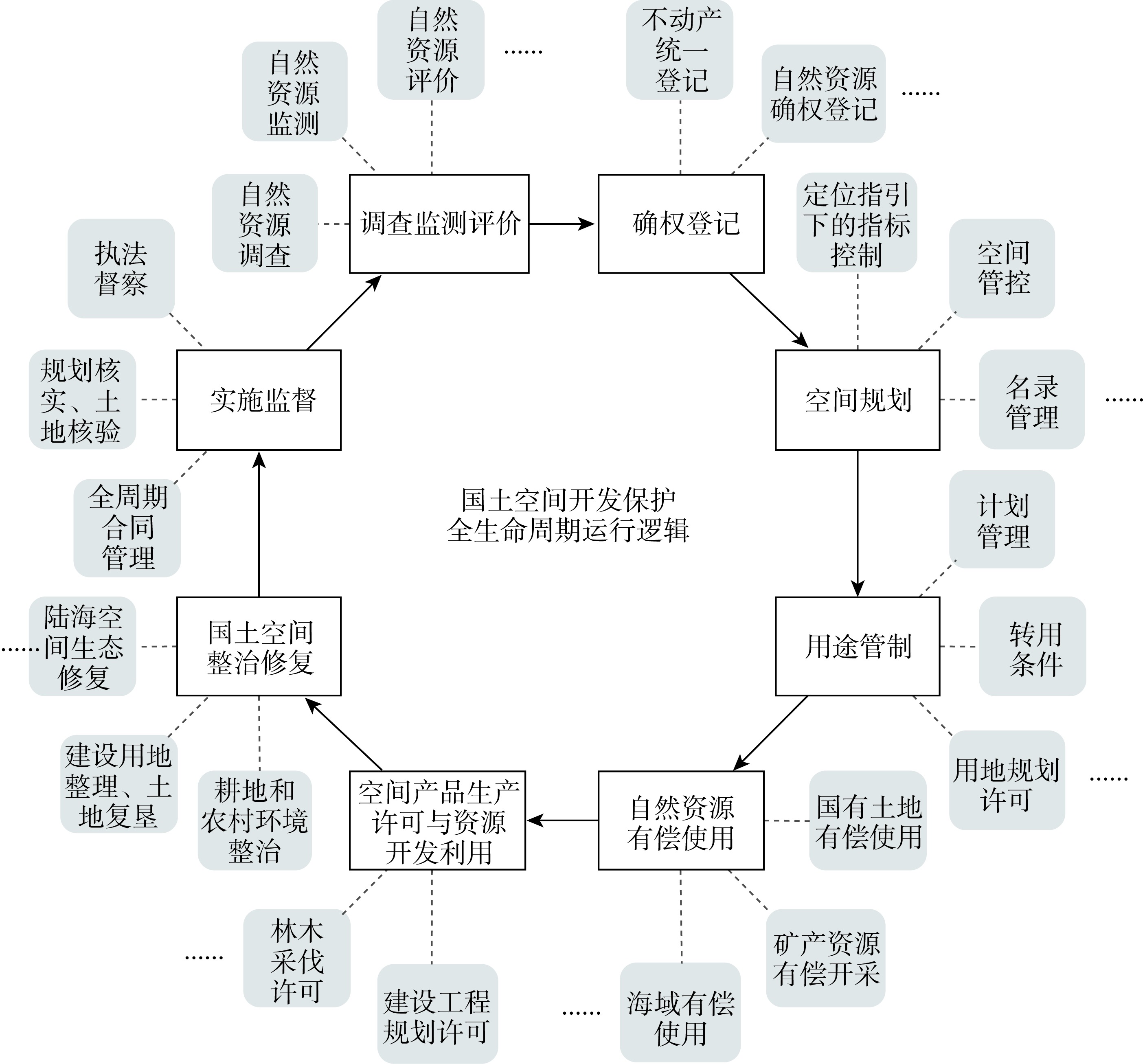
National territory spatial governance is an essential part of national governance, and spatial development rights are the critical content of national territory spatial governance. The reforms of national territory spatial planning, the regulation of territorial use control, and the property rights system of natural resource assets are advancing simultaneously. This has become a proposition of fundamental significance both theoretically and practically to examine national territory spatial governance from the perspective of spatial development rights. Based on the analysis of the basic connotation and main operation fields of national territory spatial governance, this paper dives deep into the formation basis and critical characteristics of spatial development rights and accordingly proposes the operation logic of territory spatial governance based on spatial development rights. The main findings include: (1) The main operation fields of national territory spatial governance lie in the whole life cycle of the development and protection of territorial space, which is tightly related to the allocation, regulation and realization of spatial development rights. (2) In China, spatial development rights originated from the unique two-level land development rights system. They are consisting of the changes in land use type and the intensity among the construction and non-construction land, as well as within the smaller land types. Furthermore, they have also formed a two-level structure and are implicitly rooted in the current laws and regulations, and are related to the whole process of development and protection of the whole territorial space and all kinds of natural resource types. (3) The crux of the successful operation of national territory spatial governance is the allocation and regulation of spatial development rights, as well as the interaction and coordination among multiple subjects. We suggest that further research and practice should focus on the theory of spatial development rights, the market of graded trading of spatial development rights, and the integrated coordination system, thus advancing the system's modernization and governance capacity and the reforms of the property rights of natural resource assets.
The purpose of this study is to put forward the regulation innovation logic and path based on practices of territory space use conversion permits in China. The territory space use conversion permits include permits of resources allocation and permits of risk control. The problems and challenges of the territory space use conversion permits include: unclear setting of the permit conditions, incomplete legislative integration and incomplete supervision of permit procedures. The Chinese government should standardize laws, optimize procedures, and diversify mechanisms for territory space use conversion permits. These approaches are inevitable innovative logic for protecting the common interests of natural resource owners, implementing protection, restoration and management systematically, and improving the governance ability of territory space use conversion permits. This study suggests that the government innovation permits regulation should focus on four directions: enriching basic conditions of territory space use conversion permits, paying attention to connection of key process procedures, innovating tools of permits, and optimizing authority and responsibility for administrative review and decisions.
The territorial space use regulation system is a crucial point and specific practice for the Chinese government to promote the modernization of territorial space governance system and governance capacity. Based on the theoretical framework of the construction of the territorial space use regulation system, this paper follows the dual guidance of institutional evolution and the needs of the times to explore the feasible path of territorial space use regulation system construction. The results show that: (1) The territorial space use regulation is a compound movement process of territorial resource allocation and regulation power operation. The lag of planning technology and the obstruction of regulation system will lead to the failure of space regulation. (2) The changes of China's territorial space use regulation system reflect the evolutionary law of the natural resource management system with Chinese characteristics. (3) The territorial space use regulation still faces difficulties such as the coordination of regulation subjects and the optimization of regulation systems. (4) The goal orientation of the construction of territorial space use regulation system should meet two needs, balance two sets of goals and coordinate the two pairs of relationships. (5) The construction of territorial space use regulation system should be carried out from the aspects of regulation power, regulation system and operational mechanism. In conclusion, the construction of territorial space use regulation system needs to adhere to the correct goal orientation, and take into account physical regulation and power regulation, as well as static systems and dynamic mechanisms.
How to achieve synergistic decision-making in Main Function Zoning constraints and regional development becomes a prerequisite for determining whether China's space governance strategy is effective. To demonstrate the synergetic logic between Main Function Zoning constraints and regional development, we first design a cyclic operation mode of "social system-political system-Main Function Zoning-economic system-innovation system" in this work. Second, we notice that the "maximum load" principle of resource and environmental carrying capacity serves as the foundation for Main Function Zoning classification. As a result of this methodology, we examine the early warning mechanism between Main Function Zoning constraints and regional development. Third, we deconstruct the synergetic decision-making mode of Main Function Zoning constraints and regional development into four types: "protection-surplus" "protection-overload" "development-surplus" and "development-overload". Finally, Beijing was chosen as the research sample because it is a typical preferred development zone with a tight human-land relationship. Some conclusions can be drawn as follows: (1) there are two stages for the synergistic interaction between regional growth in Beijing and Main Function Zoning restrictions. Beijing amassed enough wealth to exchange resources with other regions from 2008 to 2015, but its capacity for transformation falls short of the "optimization target" of Beijing's Main Function Zoning. From 2016 to 2020, Main Function Zoning constraints optimized Beijing's spatial production through social participation, government governance and technological advancement, thus impacting the direction of regional development. (2) The behavioral strategy of regional growth that triggers the Main Function Zoning warning at the factor scale includes urban land use, population size, energy and water resources, air pollution and solid waste management, and soil erosion management. In particular, the detrimental effects of excessive socioeconomic activity almost resulted in an irreversible overloading of the environmental system from 2008 to 2015. From 2016 to 2020, The key factors for regional development triggering the warning of Main Function Zoning restrictions are the scarcity of water, land, and energy. Furthermore, this conflict can worsen if the current rate of spatial production growth is maintained from 2021 to 2026. (3) Given to its synergistic state, a cross-decision model is suitable for Beijing. Specifically, the Main Function Zoning constraints limit the possibilities for regional development and force the city to turn into a "resource-efficient society", making it harder to fully access important development aspects. Regional growth should be given priority in the future by taking into account the potential to change Main Function Zoning restrictions. Meanwhile, those binding metrics that are necessary to achieve the "optimization target", such as ecological frangibility, ecological significance and natural disaster risk, must be subdivided into components that are connected to the regional development's behavioral approach. For the new pattern of land and space development in China, we think the results presented above can serve as a useful action guide.
In an information society, the intensification of flowing space leads to spatial compression and activation, accelerating the restructuring of economic and social spaces. Regional spaces have become a complex amalgamation of "flowing space" and "regional space", prompting the updating and upgrading of modern theories on regional functionality. Drawing upon theories such as the human-sea relationship regional system, location theory, and geographic nature, and focusing on the scientificity of regional evaluation, the objectivity of factor mobility, and the reality of land-sea coordination, this study proposes a theory and model for identifying the regional functionality of coastal land-space. (1) Based on the new concept of "adaptive land use according to local conditions", and considering the inherent characteristics of land-sea element circulation in coastal areas, a theory for identifying the regional functionality of coastal land-space is proposed. The essence of coastal regional development lies in the optimization and adjustment of the human-land relationship regional system. It is necessary to not only adhere to the suitability of geographical space but also achieve adaptability to the geographic environment. Only by combining the static regional endowment with dynamic factor mobility can the optimal allocation of human-land (sea) relationships within the system be achieved. (2) Based on the concepts of "spatial suitability" and "environmental adaptability", a "new spatial equilibrium model" for land-space utilization is constructed, with environmental adaptability serving as an important supplement to the identification of the regional functionality of coastal land-space. The focus is on the active adaptation process of human activities triggered by the circulation, aggregation, and diffusion of mobile factors between regions and between land and sea. This enhances the fluidity characteristics of identifying regional functionality in coastal areas. (3) In view of the practical difficulties faced by the spatial planning of coastal areas in terms of zoning theory, technology and data support, based on the principle of land and sea integration, through the scenario matrix analysis of the contradiction between land and sea space utilization, the four modes of land and sea integration are refined, and the technical scheme of matching land and sea elements and spatial optimization between administrative units and grid space is discussed.
Low-carbon development of territorial space provides the basis for realizing the strategic goal of the carbon peak and the carbon neutrality. The city region is a key regional unit with dual attributes of target transmission and strategy implementation in territorial space. It is of great significance to promote the realization of the "dual carbon" goal and to reveal the level of carbon emissions and spatial difference of low-carbon development efficiency of territorial spatial in cities for shaping the low-carbon sustainable territorial spatial pattern. This study explored the methodological system for measuring carbon emissions in territorial space, analyzed the characteristics of spatial differences in the efficiency of low-carbon development in city territorial space from economic, social and ecological dimensions based on the measurement results, further proposed a spatial governance-oriented optimization strategy, and finally conducted an empirical analysis using Suzhou city as an example. The results showed that: (1) The built carbon emission measurement method and low-carbonization development model of city territorial space can effectively measure the carbon emission characteristics of Suzhou city and its spatial differences in low-carbonization development efficiency. (2) The total carbon emissions in Suzhou in 2020 were 238 million tons, and the high-value parcels of carbon emissions were concentrated in various industrial agglomerations, while the low-value parcels were dispersedly distributed in the rural areas and the main areas of various carbon sinks. The development efficiency of territorial spatial low-carbonization varied significantly at different scales, mainly reflecting regional differences at the county and district scales and urban-rural differences at the township scale. Meanwhile, regions with relatively high levels of economic and social development had higher economic and social low-carbonization development efficiency, but ecological low-carbonization development efficiency was often lower. (3) According to the different spatial types of districts and townships, this paper promotes the transformation of green development of economy and society, bringing into play the role of territorial spatial planning in emission reduction and carbon sequestration, and building a composite and coordinated, low-carbon and sustainable territorial spatial pattern.
Ecological restoration of territorial space (ERTS), as an important strategy for the protection of territorial space development in the new era in China, is different from ecological restoration of small areas in the general sense, nor is it a way to assume legal responsibility. Systematic restoration and comprehensive governance are the meta-theory and methodology of ERTS, and the realization of institutionalized governance through legal system construction is an important path to promote systematic restoration and comprehensive governance. By examining the current governance practices of ERTS under this perspective, this study suggests that there are still deviations in the perception of governance values, the governance logic is still not self-consistent, and the legal framework is still imperfect. To this end, the legal system of ERTS should be constructed to strengthen the fundamentals, stabilize expectations and benefit the long term, thus promoting the effective implementation of ERTS strategy. And the path of its construction is as follows: to realize the top-level design of ERTS based on three major strategies; to improve the institutional mechanism with the logical thread of spatial order reshaping and pluralistic co-management; to improve the governance institutional framework with the "Law on the Protection of Territorial Space Development" as the carrier.

Mixed land use in urban built-up areas is important for promoting intensive use of urban land and improving the level of land spatial governance. This paper takes seven districts and counties in Fuzhou as the study area and uses multi-source data to extract the built-up area of this city. Based on POI data and natural language processing technology (BERT model), a mixed pattern extraction method (MixedFunc2Vec) that takes into account the semantics of urban mixed functions is constructed at the block scale, and the study of mixed land use in urban built-up areas is carried out from two dimensions of mixed functions and structures of land use. The results show that: (1) MixedFunc2Vec method solves the problem of "multiple meanings of words" in traditional city function semantic extraction, captures richer semantic information of POI, and extracts six types of mixed function patterns. (2) In the built-up area of Fuzhou, mode 6 (residential + public services + green space) has the richest land use structural diversity, while mode 5, which is dominated by various industries, is at the lowest diversity level and shows a cluster development trend of multi-location and multi-center. (3) In terms of structural compatibility, there are about 1803 blocks in the built-up area with a compatibility index of 0.7 or more. The average compatibility index of mode 1 (residential + commercial services) and mode 6 (residential + public services + green space) are both 0.8525, except for the industrial function-oriented areas and their surrounding areas, which still have room for improvement. (4) Based on the measurement results of structural diversity and compatibility, the blocks in the built-up area of Fuzhou can be divided into four types, including high-high, high-low, low-high, and low-low patterns, and suggestions are made to adjust the blocks based on different mixed functional patterns. This study can provide some scientific basis for enriching the existing theoretical and methodological system of mixed land use, urban spatial pattern optimization and territorial spatial planning policy formulation.
At present, the urban renewal action of Wuhan has changed from large-scale demolition and construction to the era of "retaining, replacing and dismantling". The transformation mode has also changed from local transformation to continuous renewal. In the current era, it is particularly important to identify urban "retained, replaced and demolished" units intelligently. Recently, the combination of AI and remote sensing has been widely used for the identification of typical surface features of natural resources, cultivated land protection, and law enforcement supervision. In this paper, we combine AI and remote sensing to identify "retention, reconstruction and demolition" units. First, we establish training samples of the "retention, replacement and demolition" unit, then use the deep learning network to establish the artificial intelligent model, and finally select the remote sensing data to carry out the identification of "retention, replacement and demolition" unit in Wuhan. The integration of remote sensing and deep learning improves work efficiency of the identification of "retaining, replacing and dismantling" units, and provides scientific basis for solving the pain points in urban renewal.
The purposes of this study are to explore the zoning of grain production regions based on systematic conservation planning method, to analyze the encroachment of urban agglomeration expansion on high-quality farmland under the two scenarios of coordinated development and independent development of cities within the urban agglomeration, and to provide reference for regional grain production functional area identification, resource allocation optimization and spatial layout planning. The research methods are as follows. Based on the urban flow theory and PLUS model, the expansion of Pearl River Delta urban agglomeration in 2030 under the two development scenarios is simulated and predicted. Based on the concept of system conservation, the functional areas and reserve areas of grain production are identified, and the encroachment of different expansion results on grain production regions is analyzed. The results indicate that: (1) The simulation results of urban agglomeration expansion under the scenario of coordinated development of various cities in the Pearl River Delta are more consistent with the actual development trend. (2) Based on the concept of systematic conservation planning, the farmland in the study area is divided into functional areas for grain production, reserve areas for grain production, and other areas. (3) Compared with the independent development scenario, the expansion of urban agglomeration based on urban interaction will encroach less grain production functional areas and grain production reserve areas. In conclusion, the zoning method of grain production functional regions can coordinate the multiple goals of socio-economic development, farmland protection and food security, and can provide suggestions and basis for optimizing the development and protection pattern of territory space under the background of urban regionalization.
Clarifying the relationship between People-Land-Industry is the theoretical basis for revealing the regional heterogeneity of land spatial pattern evolution. On the basis of discussing the influence mechanism of the Trade-Economy-Population system on the regional differences in the spatial evolution of the border areas, this paper applies the geo-transfer map and the standard deviation ellipse model to analyze the spatial evolution of Urban-Agricultural-Ecological space, and uses the Theil index model to measure the impact of trade, economic and population factors on the regional differences. The results show that: (1) There was a sequential difference in the change speed of territorial space pattern in the China-Vietnam border zone, which first slowed down and then accelerated. The change speed of Guangxi section showed the a 'U-type' evolution characteristic of decreasing first and then increasing, while the change speed of Yunnan section showed a 'V-type' change process of sharply falling to the bottom and then accelerating to rise. (2) The evolution of territorial space pattern in the China-Vietnam border zone responded to the localized differences in the regional development system. The agricultural and ecological spaces in border areas were frequently converted into urban space, and the conflict between agricultural and ecological space in the non-border areas was expedited. (3) The evolution of territorial space pattern in the China-Vietnam border zone was spatialized, which was acute in the northwest and slow in the southeast. The center of gravity of urban and agricultural space moved west to north, while the center of gravity of ecological space moved from southeast to northwest. The evolution intensity of territorial space pattern in Yunnan section was higher than that in Guangxi section. (4) The effect of Trade-Economy-Population system on the regional differences in territorial spatial evolution gradually weakened, and the disturbance degree of trade subsystem on territorial space pattern evolution was higher than that of economic and population subsystem. Border trade, economic development and population distribution shape the temporal, local and spatial pattern of border areas. Regulating the impact of border trade on territorial space is an important measure to alleviate spatial conflicts in border areas.
The effectiveness of government management can be increased and the efficacy of ecological construction can be strengthened by evaluating the performance of ecological projects in the perspectives of different stakeholders. Based on the theory of public value, this paper employed CRITIC-entropy weight method, fuzzy matter-element model, obstacle model and other methods to evaluate the performance of Pastureland Rehabilitation Project in Sanjiangyuan National Park from five dimensions of goal rationality, process efficiency and process fairness, result benefits and result sustainability in the perspectives of the local governments and herdsmen. Besides, the similarities and differences of performance perception, obstacle diagnosis and adjustment willingness between the local governments and herdsmen were also been analyzed. The results showed that: (1) The Pastureland Rehabilitation Project in Sanjiangyuan National Park performed well overall from the standpoint of local governments, however the performance of the process fairness was relatively mediocre. There were significant differences in the overall performance and value performance among four counties in Sanjiangyuan National Park, but five kinds of value performance of each county had reached a benign coupling state. (2) Except that herdsmen's evaluation of the process efficiency of Pastureland Rehabilitation Project was higher than that of local governments, their evaluations of overall performance and value performance of the project were comparable to the government's. (3) The project's barriers from both the government's and herdsmen's perspectives were similar, mainly including the industrial promotion, improvement of herdsmen's livelihood and communication between the two groups. (4) Various gains and losses led to a relatively high adjustment willingness of the local governments and a relatively low adjustment willingness of the herdsmen, but both sides primarily proposed to raising the subsidy, upgrading the infrastructure and boosting policy publicity. The study can serve as a guide for comprehending the cognitive variations among the various stakeholders of Pastureland Rehabilitation Project and for optimizing project construction.
National parks are an important part of the construction of ecological civilization in China, and a practical action to promote natural ecological protection and protect biodiversity. However, natural disasters are an important factor affecting the construction and sustainable development of national parks. The Sanjiangyuan region is an important ecological barrier in China, and the ecological environment is extremely fragile and sensitive. It has poor self-regulation and repair capacity and once damaged, it is extremely difficult to recover. The frequent occurrence of earthquakes and their secondary disasters in the Sanjiangyuan region has a great impact on the ecological environment. In order to systematically assess the impact of earthquakes on the ecological environment in the context of the construction of the Sanjiangyuan National Park, this paper constructs a framework for assessing the direct and indirect impacts of seismic hazards on the ecological environment of the park based on the assessment of several seismic hazards on the Tibetan Plateau in recent years. Based on this framework, this paper takes the 2021 Qinghai Madoi earthquake as an example, and comprehensively evaluates the impact of the earthquake on the ecosystem and ecological infrastructure of Sanjiangyuan National Park and the loss of ecosystem service value through field surveys, remote sensing, and GIS methods. On this basis, the idea of building an assessment platform for the impact of earthquakes on the ecological environment of national parks is proposed. The results show that the earthquake seriously damaged the ecological management and protection facilities of Sanjiangyuan National Park and the structural stability of ecosystem elements such as glaciers, permafrost, vegetation, surface and water system, destroying regional ecosystem functions. The value loss of ecosystem services caused by the earthquake reached 149.267 billion yuan, far exceeding the direct economic loss of 11.695 billion yuan. The evaluation framework and platform construction ideas proposed in this paper can provide a reference for evaluating the impact of future earthquakes on the ecological environment of the Sanjiangyuan region and even the entire Tibetan Plateau National Park.
Aboriginal people are an important part of national park ecology. It is crucially important for the sustainable development of national parks to deeply reveal the formation mechanism of aboriginal people's intention to support the construction of national parks. Taking Diaoluoshan area of Hainan Tropical Rainforest National Park as an example, this paper empirically investigates the benefit perception and cost perception of aborigines on the impact of national park construction, discusses the relationship between community power and support intention, and further analyzes the regulatory role of government trust and the intermediary role of livelihood capacity. The results show that community power has a positive impact on aboriginal benefit perception and a negative impact on cost perception. Benefit perception has a significant positive impact on support intention, while there is no significant correlation between cost perception and support intention. The effect of livelihood capacity on support intention is both direct and indirect through benefit perception. Government trust has a significant moderating effect on the relationship between impact perception, livelihood ability and support intention. Government trust has a positive regulatory effect on the relationship between benefit perception and support intention, and has no significant regulatory effect on the negative relationship between cost perception and support intention.
The total water resources in Tibet Autonomous Region are abundant but unevenly distributed in space and time, which makes it difficult for water resources to support the efficient and sustainable development of local production, life and ecology. Combined with the actual situation of Tibet and based on the PSR model framework, the water resources carrying capacity of the region was empirically evaluated from the perspective of the "production-living-ecological" function, and the coupling coordination relationship among the subsystems of the "production-living-ecological" function in water resources carrying capacity was further explored by adopting the coupling coordination model. The results show that: (1) From 2015 to 2020, the water resources carrying capacity in Tibet was relatively low, showing a fluctuating and rising evolutionary trend in general, which, however, presented significant spatial heterogeneity. (2) The carrying capacity of the "production-living-ecological" subsystems of water resources varied significantly, with the carrying capacity of the production, living and ecological subsystems all showing an increase. The carrying capacity of the production and ecological subsystems presented the spatial pattern of "high in the east and low in the west", while the carrying capacity of the living subsystem showed the alternating characteristics of "stronger in the middle than in the periphery". (3) The subsystems of water resources carrying capacity in Tibet was in a relatively high-level coupling state, and those of the coupling coordination degree presented the spatial pattern of "Southeast Tibet was higher than Northwest, and Nyingchi was significantly better than other cities". In view of the low comprehensive level of water resources carrying capacity in Tibet and the low coordination degree of subsystems of water resources carrying capacity in Northwest Tibet, it is suggested to relocate from other places, adjust the industrial structure, strengthen the construction of municipal water conservancy facilities and improve the system of farmland water conservancy projects, so as to improve the comprehensive level of water resources carrying capacity in the whole region and the coupling coordination degree among the "production-living-ecological" subsystems of water resources carrying capacity in Northwest Tibet.
Based on the international soybean trade relationship matrix for six time sections from 1995 to 2020, this paper identified the telecoupling system of soybean trade and the direction and the intensity of trade flow with the help of social network analysis from the perspective of telecoupling, and analyzed the spatio-temporal evolution characteristics and influencing factors of the international soybean trade network. The results show that: (1) The international soybean trade is becoming more and more widely linked by telecoupling, but the whole is in a weakly connected state. And the network cohesiveness and connectivity are increasing with certain characteristics of a small-world structure. (2) Soybean sending systems are concentrated in a few American countries, soybean receiving systems are numerous and mainly distributed in the Eastern Hemisphere, and developing countries such as India and South Africa have prominent spillover effects as trade intermediary points. With China, Brazil and the United States as the absolute core, the international soybean trade network shows an obvious polarized structure. (3) The cohesive subgroups of the soybean trade network show a spatial evolution of structure from a fragmented collection of small areas to a geopolitical agglomeration of large areas. (4) Geographical distance, manufacturing development level and soybean production area are the core driving factors of soybean trade network evolution. Soybean production area has a significant positive effect on trade volume, and geographical distance has a significant negative effect on trade relationship. However, in the weighted network, the influence of geographical distance is positive, which means that the coupling effect between long-distance systems with complementarity is stronger. (5) There is a positive relationship between soybean expansion area and forest loss area in some trading countries, especially in South American exporters such as Brazil, Paraguay and Bolivia. Soybean trade transfers the pressure of resources and environment from many importers in Asia and Europe to a few exporters in South America.
Commons often lead to a "tragedy of the commons" because they can be accessed freely, that is, overexploitation of commons usually leads to resource degradation. Since Garrett Hardin published an article "Tragedy of the Commons" in Science in 1968, there has been an increasing number of studies on commons governance to avert the tragedies. With the development of urbanization, industrialization and increase of population, the overexploitation of natural resources by human activities has become increasingly serious, such as air pollution, carbon emissions, marine pollution, and depletion of mineral resources In order to promote the sustainable use of commons, it is necessary to review the theoretical and practical progress of the "tragedy of the commons" theory and its related study of governance. Therefore, this paper first reviews the theory of "tragedy of the commons". Then, obtaining 43830 paper, documents, etc. from Google Scholar that have cited Harding's articles by the end of 2020, this paper analyzes the keyword time series of these citing literatures, and combines with the development context of the research to summarize the progress of theory. We found the theoretical progress includes five aspects: examination of "Tragedy of the Commons" theory, analyses of the property right system of public resources, multiple governance types of commons, sustainability analysis of Social-Ecological Systems (SES), and governance of global resources. Their inspirations for sustainable governance in China are: (1) There is no "panacea" for resource governance, and it is necessary to explore the "diversification" of the system; (2) Accelerate the improvement of the property rights system for natural resources, and build a property rights system for natural resources owned by all the people, based on China's national conditions; (3) Implement multiple governance types on natural resources and build a collaborative, co-governance and shared environment; (4) Implement systematic governance of natural resources to promote the harmonious coexistence between human and nature; (5) Govern global resources through institutional innovation, and build a community with a shared future for mankind. The review of the development of "the tragedy of the commons" and its governance can provide important theoretical and practical enlightenment for the sustainable development of China's resources and environment and the modernization of governance capabilities. This also indicates an interdisciplinary academic innovation path and proposes potential research directions.