Territory spatial planning is an important means for modern countries to implement spatial governance, and it is a rational design for realizing specific strategic intentions. The theory and technical method in the process of formulating planning will change with the development of the times. In order to understand the conceptual innovation of territory spatial planning and governance in the era of eco-civilization, five well-known experts in this field are invited to conduct interviews on the value orientation, goal pursuit, key tasks, implementation paths and main fields of territory spatial planning and governance. Experts believe that: (1) The territory spatial planning needs to handle the imbalance between individual interests with a higher overall interest principle, promote the maximization of specific interests and ensure the minimum satisfaction of other interests under the guidance of overall interests. (2) The goal of territory spatial planning and governance is not to pursue "universal prosperity of region", but to pursue "universal happiness of the people" and create a high-quality territory suitable for living and working. (3) Territory spatial planning needs to coordinate security and development, reasonably and appropriately develop and utilize natural resources, and promote the harmonious coexistence between human and nature. (4) Territory spatial planning needs to conform to the trend of economic spatial pattern change and establish a high-quality urban ecosystem and security system. (5) Cities are the key areas of territory spatial planning and governance. It is necessary to improve the logic of city governance by expanding the understanding of urban multi-attributes and systematically studying and judging the problems and causes of spatial governance. Through expert interviews, it can be seen that territory spatial planning is essentially the reconstruction of spatial relations. We need to promote the harmonious coexistence of human and nature and we need to deal with the interests of multiple subjects and realize social harmony. It is also necessary to respect the operating rules of different levels of territory units such as the life community of mountains, rivers, forests, lakes, grass and sand, and maintain and repair the links mechanisms between various elements.
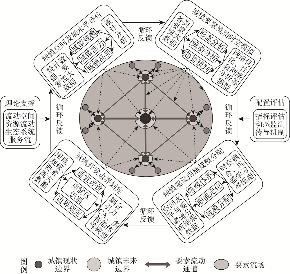
The existing urban construction land allocation mainly follows the guidance of spatial development, which is carried out by using static data and land allocation standards, evaluation and prediction models. There are some phenomena of "regional preference" and "seeking large scale". In the new era of emphasizing the construction of ecological civilization and high-quality development, the implementation of territory spatial planning strategy requires that the allocation method of urban construction land needs to be innovated in time. This project focuses on the inevitable trend that the urban place space will be transformed into the urban flow space under the deep influence of information or intelligent technology in the future, and considers that the spatiotemporal flow and distribution of production, life and ecological elements of different scales will be the key to the scientific allocation of urban construction land. Therefore, the project uses multi-source big data of element flow and multi-disciplinary analysis methods, trying to establish a new method framework from four aspects: evaluation of urban spatial development level, spatio-temporal simulation of urban element flow network and land allocation, identification of urban element functional area and delimitation of development boundary, and dynamic evaluation of urban construction land allocation effect. Firstly, it is found that the evaluation of urban spatial development level needs to comprehensively consider the ability of cities to control, attract and overflow the current regional elements, and construct the evaluation index system from three aspects of spatial development scale, vitality and quality. Secondly, in the process of regional distribution of urban construction land index, we pay attention to using network optimization model and social network analysis method to describe the flow law of regional elements, and find out the cities with different levels and types of combination of "spatial development level and element control" through time-space coupling model. Thirdly, the future expansion direction and boundary shape of cities are determined by the spatiotemporal matching of supply and demand between the flow changes of various internal elements and the functional space layout. It is necessary to identify the functional influence area and flow preference of elements by using models of spatiotemporal coupling, gravity, cellular automata and agent-based system. Finally, the evaluation index of urban construction land allocation effect needs to reflect the requirements and trends of future urban development, such as ecological civilization, high quality, smart governance and integration. These research results can provide reference for the delimitation and implementation of urban development boundary in territory spatial planning.
National territory spatial planning is a guide for national spatial development, a spatial blueprint for sustainable development, and an important starting point for improving the modernization of the national spatial governance system and governance capabilities. Therefore, it is essential to promote the effective implementation of national territory spatial planning. Planning transmission is a key link to ensure the implementation of national territory spatial planning. There are several reasons for problems in the compilation and implementation of national territory spatial planning. Due to the lag of planning theories and methods, and the limitations of local practice, existing research results emphasize the vertical transmission of rigid constraints, functional zoning, spatial elements, etc. People are currently inadequately considering the transformation of space governance in the New Era, the unification of administrative power management boundaries, and the accuracy control of the transmission of spatial elements, which has led to the defect in transmission of technical ideas for national territory spatial planning. This article is based on the preparation and pilot practice of Guangzhou's land and space planning, starting with the transformation of governance at the conceptual level, the matching of government duties at the system level, and the management of elements at the technical level, to explore the integrating spatial governance into planning transmission, the rigid constraints of national will and the flexible guidance of local competitiveness, and the intensity and precision of administrative control at different spatial scales. The paper points out that planning transmission should adopt technical ideas such as two-way feedback, power and responsibility list, rigid and elastic combination, scale tolerance, dynamic balance, etc., to solve the key issues of planning transmission between different levels of master plans, and between master plans and detailed plans. It further proposes that planning conduction is not simply a "top-down" vertical conduction, but should also include "two-way feedback" in response to local development demands and specific field regulations, and a rigid conduction mechanism must be used to transmit strategic intentions downwards. When dealing with the relationship between the government and the market, it is necessary to strengthen flexible control and guidance to enhance the flexibility and adjustability of planning; in terms of the transmission of spatial elements such as land zoning, control line delineation, special facility layout, etc., administrative control of different spatial scales should be grasped through the process of adapting the space from overall blur to partial clarity, from structure to map spots, from partition to plot, from demarcation to delineation, to clarify the tasks, permissions and control accuracy of each level of planning. Follow the dynamic balance principles of "constant scale, variable form", "constant standard, variable location" and other dynamic balance principles to allocate space resources in a reasonable and detailed manner to cope with the dynamic changes of the influencing factors of the planning and layout plan during the implementation process, so as to finally realize the ecological environment. The comprehensive balance of civilization and urban economic development, rigid constraints and flexible adjustments, refined management and fuzziness. The results can provide research support for improving the national territory spatial planning system in the era of ecological civilization and promoting the effective implementation of planning.
Territory spatial pattern plays an important role in coordinating regional protection and development. Its basic premise is to clarify the connotation of territory spatial pattern and build a scientific and effective conduction path of territory spatial pattern. Based on the logic lines of "raster-land category-administrative region-whole area" and "suitability evaluation-territory spatial reconstruction-dominant function identification-regional consistency abstraction", this study develops a research framework for territory spatial pattern scale decomposition and conduction path. Firstly, the suitability of territorial space is assessed in terms of three aspects: ecological protection, agricultural production, and urban construction, with the type, intensity, and spatial pattern of territory spatial potential conflict identified using a model for identifying territory spatial potential conflict. Secondly, the "rigid constraint" and "elastic guidance" planning mechanisms are applied to mediate potential conflicts in territorial space and reconstruct the territorial spatial pattern. Finally, the location entropy model is utilized to determine the dominant function of territorial space and to establish a strategic plan for territory spatial development. Dongying city is used as an example in this research to conduct an empirical study. The results show that: (1) The territory spatial suitability of Dongying is crucial for ecological protection, suitable for agricultural production and urban construction, and the potential conflicts of territorial space are mainly moderate. (2) Ecological space, agricultural space, and urban space are all part of the territory spatial reconstruction. From coastline and coastal areas to inland regions, the boundary between protection and development in geographical units is 19.69 km and 1.6 km, respectively. The proportions of territory spatial reconstruction patterns, on the other hand, vary substantially between counties (cities and districts). (3) Dominant function zones include important ecological function zones, agricultural production zones, urbanization development zones and elastic development zones that provide differentiated control strategies for zoning classification. (4) The ecological protection pattern of "one heart, one screen, and one corridor", the development and utilization pattern of "one circle and two districts," and the flexible development pattern of "two belts" comprise the strategic pattern of territory spatial protection and development, which establishes the goal of sustainable territory spatial utilization. The findings of this study can be used as a guide for developing territory spatial planning and coordinating the effective allocation of regional territory and resources in the New Era.
As a key content of the city-level territory spatial planning system, the vertical hierarchical transmission of core indicators is of great significance to the optimization of the municipal territory spatial utilization pattern and the overall planning. Considering the inadequate and imprecise research of current index transmission, following the research idea of "core transmission index selection→logical index transmission technology construction→ multi-scenario simulation prediction", this paper takes Changde city as an example to study its core indicators transmission of territory spatial planning in 2035 "City→ District (County)" conduction. The results show that: (1) Based on the technical transmission logic of "indicators global total prediction-spatial layout simulation-regional classification transmission", through the comprehensive utilization of SD and GeoSOS-FLUS model, the core indicators of city-level territory spatial planning can be transmitted effectively and scientifically by combining "top-down" and "bottom-up" processing. (2) The SD model of "human-land-industry" coordination of land space utilization in Changde was constructed to obtain the total number of core indicators for territory spatial planning of this city in 2035, and the corresponding comprehensive benefits of territorial utilization will reach 1299.425 billion yuan, an increase of 207.75% compared with 2018. (3) From the indicators transmission results, the social and economic indicators of each county (county-level city, district) of Changde will maintain an overall growth trend except for the size of permanent residents in 2035. The boundary indicators will achieve "only increase but not decrease". The changes in land use indicators vary, but they are generally in line with the main body of Changde. The direction of the construction of the functional area, and the core indicator transmission results are in line with reality.
Planning zoning is a new zoning level proposed by the unified land and space zoning management and control system to make up for the lack of structural management and control at the meso-micro scale. The research on its technical methods is of great theoretical and practical significance. Based on the analysis of the requirements of "shrewdness", "accuracy" and "refinement" of spatial governance and the comparison of spatial zoning methods with different zoning logics, this paper studies and constructs a zoning method combining qualitative and quantitative methods from the development law of the main function "point axis" by using technical methods such as spatial analysis, multivariate statistics and weighted Voronoi diagram. In addition, this paper conducts an empirical study with Huangmei as a case. The research shows that: (1) The method in this paper can effectively delineate the zoning units in line with the connotation of primary planning zoning in the "Guidelines for the Compilation of Municipal Land and Space Master Plan (Trial)", which makes up for the lack of planning zoning methods. (2) Relying on the "top-down" zoning logic of functional development structure, the connotation of spatial structure management and control is effectively integrated into the planning zoning, realizing the guidance and management of spatial structure. (3) Through the weighted Voronoi diagram model, the optimal function orientation of space is identified, which improves the scientificity and technicality of planning zoning.
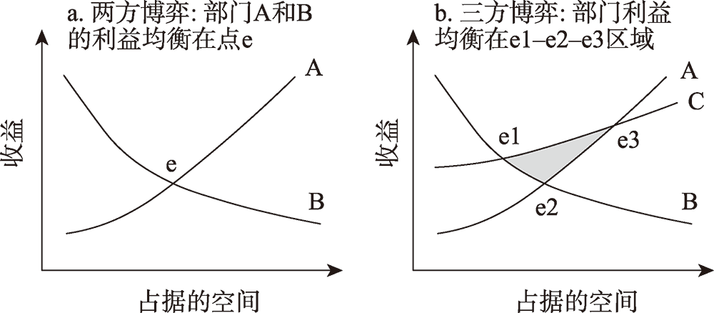
Facing the territorial symptom such as urban sprawl, rural decline, and environmental degradation, territory spatial planning needs to integrate multiple plans that reflect the maximum interests of various stakeholders and usual conflict between them to achieve "Multi-Plan Integration". This paper proposes an approach to coordinate the conflicts between different plans based on security pattern theory. This approach mainly includes: (1) On the epistemology level, territory spatial planning is considered as a rational planning process, in which the generated plans are defensible by adopting the minimax-constraint approach, and the outcomes are acceptable by all stakeholders through the spatial game to coordinate their competitions for limited land. (2) On the methodology level, the first stage is to identify security patterns functioning as the basis for safeguarding the goals of all stakeholders and the coordination etween them, and the second stage is to negotiate on the use of competitive land using these security patterns. In practice, it is essential to establish an institutional mechanism to coordinate planning conflicts. Moreover, for the disadvantageous position of natural and ecological capitals in multi-party games, it is necessary to construct an ecological security pattern and ecological infrastructure to provide comprehensive ecosystem services, which would help to reinvent the good earth.
The territory spatial utilization efficiency is an important element of the quality of regional economic and social development, and the spatio-temporal coupling relationship with high-quality development has an important impact on the realization of regional coordinated development. Therefore, on the basis of the planning of the main function area, the Super-SBM model, spatial classification, ESDA and coupling coordination model were used to reveal the coupling relationship between the territory spatial utilization efficiency and high-quality development in Wanjiang City Belt from 2011 to 2019. The conclusions can be drawn as follows. (1) The territory spatial utilization efficiency of key development areas was significantly greater than that of key ecological function zones and the main national agricultural products production areas, and the temporal differentiation pattern showed that the gap between the key development zones was the largest, followed by the main national agricultural production areas, and the key ecological function zones were the smallest. (2) In terms of spatial distribution, the high-efficiency areas were concentrated around Wuhu, and the phenomenon of high-value agglomeration was gradually dispersed, the general-efficiency areas were mainly distributed in Anqing and Chizhou, and the low-efficiency areas gradually moved northward to Chuzhou. (3) As for spatial correlation characteristics, the global spatial correlation of the two major systems changed from negative to positive from 2011 to 2019. The local spatial correlation was mainly based on the significant HH areas and the significant LL areas, and the significant HH areas were mainly distributed in the southeast of the Wanjiang City Belt, the significant LL areas were concentrated in the northern part and the agglomeration range had been expanded. (4) From the view of the characteristics, the level of coupling and coordination of territory spatial utilization efficiency and high-quality development in different spaces has gradually increased. Furthermore, the degree of coupling and coordination of urban space tended to be low level, the agricultural space transitions from a high-running-in to a high-coordination, the ecological space gradually turned to low-coordination, and the comprehensive level of coordination had been in a high-degree stage.
The era of ecological civilization construction emphasizes the comprehensive growth of ecological and economic benefits. In order to respond to this demand and enrich the natural ecological perspective of territorial space research, by taking Zhuanghe city of Liaoning province as an example, this paper studies the ecological value evaluation and economic compensation in small watershed areas. First of all, based on water system classification law called Strahler-Horton, We take the hydrological analysis of GIS as the main tool to simulate and divide the small watershed of Zhuanghe city. Taking the dumping points and watersheds at all levels as boundaries, small watersheds are divided into sub-watersheds and micro watersheds. The units divided under the small watershed system have ecological integrity, in addition, the units have index conductivity, which come from original administrative management system including county, township and village. And then, under the principle of ensuring ecosystem integrity and clear division of powers, this hierarchical and partitioned spatial system is structured by superimposing the boundaries of small watershed areas and administrative areas, including county, small watershed, sub-watershed and "micro watershed+village". Finally, about the small watershed and sub-watershed, owing to their complete ecosystem, the method called eco-economic relative priority model is available to obtain the ecological compensation relationship between units. About the basic unit scale called "micro watershed+village", based on evaluations including ecological importance, agricultural production suitability and urban development suitability, we divide the types of each basic unit, to make sure the implementation of ecological compensation. Through constructing the eco-economic value evaluation system, this paper looks for a method about how to balance the protection and development of land space in the mountainous and hilly areas.
The research on the evaluation of territorial "production-living-ecological" spatial functions and the coordination relationship at the township-street scale is more oriented towards humanistic demand and grassroots refined governance support in the process of territorial spatial optimization. This study proposeed a whole set of thinking framework of "fractal dimension function evaluation-coordination level measure-action direction judgment". Among them, the dual attributes of space membership and space quality were considered to construct a comprehensive evaluation index system for the "production-living-ecological" spatial functions. The study then used the coupling coordination model and the bivariate spatial autocorrelation model to explore the level of coordination between functions and their respective directions for overall coordination, by taking Suzhou as an example. The results showed that: (1) The constructed theoretical framework, index system and technical method path have good scientificity and universality, and can effectively identify the spatial function distribution pattern and spatial coordination relationship of the "production-living-ecological" spaces at the township-street level. (2) Under the constraints of the higher standards of township-street scale, the "production-living-ecological" spatial functions in Suzhou had significant urban-rural differences and regional differences, and the overall level of coordination of the "production-living-ecological" spatial functions was low, showing a distribution pattern of "large dispersion and small agglomeration". Besides, the overall coordination level was mainly affected by the co-direction effect of production and living space functions, and the lack of synergy of ecological space functions showed a reverse-direction effect. (3) Promoting the comprehensive function of "production-living-ecological" spaces from different spatial types such as urban areas, townships and ecological units, improving the refined governance of grassroots territorial spaces, and realizing the overall coordination of "production-living-ecological" spaces at a larger scale can build a territorial spatial pattern with multiple functions, appropriate landscapes and coordinated progress.
The optimization of ecological security pattern can provide countermeasures and suggestions for land space protection and restoration, so as to supplement the actual lack of practical guidance of existing research on it. The construction of ecological security pattern is of great significance to optimize the protection and restoration of land space. Starting from the identification of urban and ecological source in the Hohhot-Baotou-Ordos Region, this paper constructs an evaluation index system of urban and ecological source expansion resistance, and uses the minimum cumulative resistance model to construct the ecological security pattern. Then we identify key areas of ecological protection and restoration (ecological corridors, ecological pinch points and ecological barrier points), build an ecological security network, optimize the pattern of land space protection and restoration, and put forward relevant countermeasures and suggestions. The main conclusions are as follows, at first, the area suitable for expansion of urban sources is far smaller than that of ecological sources, which is better than the expansion of ecological sources as a whole, so the regional ecological construction, protection and restoration have great potential. Secondly, the ecological space in the ecological conservation area accounts for the largest proportion of the community area of the ecological security pattern, followed by the ecological space in the optimized buffer area, and the living space in the ecological protection area accounts for the lowest. Last but not the least, 135 ecological corridors were extracted, 12 ecological pinch points and 6 ecological barrier points were identified, rivers and traffic corridors were supplemented, 164 ecological strategic points were extracted, and an ecological security network was constructed. Ultimately, it integrated natural elements such as mountains, rivers, forests, fields, lakes, grass and sand to form a land space protection and restoration pattern of "multi-core, four areas, three belts, one screen and one basin", so as to improve the integrity and connectivity of regional ecological landscape and maintain regional ecological security.
The study on strategies of high-quality development oriented ecosystem protection and territory spatial utilization has important practical significance for promoting the construction of ecological civilization in the Yellow River Basin and the balanced development in the whole China. A theoretical research framework of strategies for ecosystem protection and territory spatial utilization for high-quality development in the Yellow River Basin was constructed based on the relationship of "Pressure-State-Response". Under the framework, this paper analyzed the ecological construction and land development behavior including land reclamation, grain for green and urban encroachment brought by the pressure of urbanization, and its impact on the evolution of the land spatial patterns and ecosystem in the study area. The spatial differences in restrictions between ecosystem protection, agricultural production and territory spatial development in the basin, from the perspective of territory spatial utilization and development restrictions and the resource and environmental carrying capacity, were also examined. Based on prominent problems existing and the unique "natural-humanistic" characteristics in the Yellow River Basin, the coordinated development strategy of "water resources protection-green development-cultural inheritance" for the high-quality development were proposed, including the National Nature Reserve protection, the ecological infrastructure network construction, the green industry development and characteristic cultural inheritance, and the relevant guiding policies and the safeguard measures. It can provide support and guarantee for the high-quality development in the Yellow River Basin.
The monitoring-evaluation-warning of territory spatial planning is not only an important means to supervise and ensure the effectiveness of spatial planning implementation, but also a key support for the evolution of smart planning that is "perceptible, learnable, governable and adaptive". At present, research on monitoring-evaluation-warning of national spatial planning focuses more on mechanism rather than theory, what's more important is that we are lack of a set of scientifically available monitoring-evaluation-warning techniques. In order to solve the above problems, this paper systematically analyzes and discusses the objectives and connotation of monitoring-evaluation-warning of national spatial planning, and on this basis, it constructs an application model system that covers the whole life cycle of monitoring-evaluation-warning of territory spatial planning business supported by new information technologies ("ABC" technology), such as artificial intelligence, big data and cloud computing. Finally, combined with the case of information system construction, the paper introduces the important supporting role of monitoring-evaluation-warning of territory spatial planning model system based on "ABC" technology to realize the territory spatial planning "dynamic monitoring, accurate evaluation and timely early warning". The main conclusions of this paper are as follows: (1) Monitoring, evaluation and early warning of territory spatial planning are indispensable technical links in the implementation and supervision of spatial planning, and the three are logically progressive and technologically support each other. (2) Three kinds of model systems are put forward: the dynamic perception and rapid identification model system of spatial information integrated with multi-source big data, the comprehensive evaluation model system coupling human activities and natural environment, and the land simulation and prediction model system based on artificial intelligence. (3) The practical application of three kinds of models in the information platform such as the territorial space change monitoring system, the smart planning big data decision-making platform and the 'Inteplan' information system for implementation and supervision of spatial planning embodies the important role of the model in territorial space control and governance as well as natural resources supervision.
The reform of territory spatial planning system has put forward new requirements for personnel training, and it is urgent to build a talent training system for territory spatial planning in the New Era. This research uses the potential conflict index (PCI) to study the current professional education situation of territory spatial planning in China, by using the questionnaire survey from the perspective of talent training supply and employer demand. The results show that there are about 261 colleges and universities offering majors related to territory spatial planning in China, which are characterized by diversified opening types, diversified school levels, differentiated degree systems, and the urgent need to improve the master and doctor training system. From the perspective of talent supply, talent training programs have different emphases on the requirements of mastering basic theory of planning due to the differences in subject basis, but all majors show a strong demand for planning tool application, planning practice courses and interdisciplinary knowledge integration. From the perspective of talent demand, employers attach importance to interdisciplinary talents, technical talents with both theory and practice, and professional talents with solid basic theory. This research proposes innovative ideas for the talent training system of territory spatial planning from the aspects of discipline system construction, basic study, application-oriented curriculum construction, professional evaluation mechanism and vocational training channels.
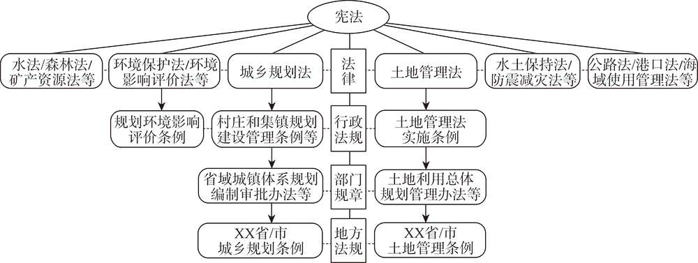
Through a systematic review of the current legal norms of spatial planning, it is found that there are problems such as lack of top-level legislation, redundant and flat external structures, and fragmented internal norms due to legislative strategies, departmental legislation, and the dependency of planning legislation. Following the "Field Law", "Law and Development" and systematic logic, the legislation of territory spatial planning should be guided by practical issues and modern governance, and it needs to pay attention to the continuity of legal system development when breaking through the barriers of departmental law. On top of that, it strives to realize the coordination of the legal system and the coherence of values. To build a legal system for territory spatial planning, the status of basic law of "Territory Spatial Planning Law" should be established internally and supplemented by supporting legislation, and externally, it should be connected with relevant legislation such as "Territory Spatial Developing and Protecting Law", territory spatial policies and its technical standards. In the end, a cone-shaped legal system of territory spatial planning featured with clear main axes, strict levels, and different orders will be constructed.
County-level planning is an essential component of China's "five-levels, and three-categories" territory spatial planning system. This paper builds a Geodesign framework for county-level comprehensive territory spatial planning based on the smart territory spatial planning ideology and requirements. The framework is established based on the classical Geodesign framework proposed by Carl Steinitz but with supporting methods and techniques supplemented. It mainly focuses on the procedure (steps), key problems, and methods and techniques for county-level comprehensive spatial planning problem-solving. Models are the core of the Geodesign framework. "Evaluation Model", which is constructed based on the "Ecological Civilization" ideology, focuses on regional ecological risk assessment. "Change Model" converts territory spatial planning to a multi-objective optimization problem to support intelligent decision-making, which combines quota limits with spatial management in county-level planning. "Impact Model" provides an approach for public participation in planning based on the "people-oriented" principle. The framework requires the support and combination of classical methods and novel techniques, including big data, internet, artificial intelligence and decision support system technology. The Geodesign framework contributes to methodological research on smart territory spatial planning and provides practical approaches for the planning ideology of "ecological civilization", "people-orientation", and "intelligent decision-making".
The "Life Community of Mountains, Rivers, Forests, Fields, Lakes and Grasses" is a new understanding of the harmonious and unified relationship between human and nature, and an integral part of the theory of ecological civilization. Aiming for the research paradigm of the "Life Community of Mountains, Rivers, Forests, Fields, Lakes and Grasses", the research focuses and characteristics of the theory and application of this "Life Community" are analyzed systematically in three stages, namely fundamental study, rapid development, and diversified prosperity. The connotation of the Life Community of Mountains, Rivers, Forests, Fields, Lakes and Grasses is re-examined, and the new conceptual understanding, basic characteristics, and the relationship between human and the Life Community are clarified. In the end, the "problem-goal-spatiotemporal strategy-purpose" path of implementation of the life community is pointed out; and an institutional system is built with emphases on monitoring and supervision of the natural resources, property rights of natural resources assets, planning of the territory, management of use of the territory, ecological restoration of the territory, and the relevant laws and regulations. In this way, the path makes the life community more scientific and practicable, thus supporting the decision-making for the territorial space governance and the modernization of the governance capabilities.
With China's urbanization entering the middle and late stages of development, and under the background of spatial planning reform and high-quality development, urban regeneration is the key issue of urban spatial sustainable development in the stock age. However, there are still some problems such as unclear positioning of urban regeneration in the land and space planning system, and how to better promote the convergence of land and space planning and integration of urban regeneration in the New Era, which needs to be explored urgently on how urban regeneration is to be an effective means to solve the urban disease and carry on the urban space management. This paper briefly reviews the research progress of urban regeneration, and takes the large-scale urban regeneration planning-London opportunity area planning as a typical case, analyzes the concept connotation, evolution process and different types. It concentrates on the analysis of three typical opportunity area planning projects, including commercial development with emphasis on finance and innovation industry, cultural tourism with emphasis on maintaining and continuing historical features, and industrial development with emphasis on brownfield restoration and developing green industry. On this basis, the inspiration of London opportunity area regeneration planning to China's land and space planning is put forward to make clear the location of urban regeneration and the compilation requirements and standards in the five-level and three-type land and space planning system; and to take urban regeneration as the key point to promote the harmony between the quality of human settlement environment and social equity of urban stock space. Meanwhile, different strategies for urban regeneration need to be constructed aimed at different types of cities and different types of urban plots according to local conditions. In addition, we should learn from nature-based solutions and respect the natural resources and geographical attributes of urban areas; continue the historical context of the city, explore and create a local and distinctive urban spirit.