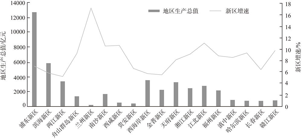
China has entered a critical period of building a modern and powerful socialist country. Meanwhile, the world is undergoing profound changes unseen in a century, which poses severe challenges to Western China's modernization. Outline of the 14th Five-Year Plan for National Economic and Social Development of the People's Republic of China and the Vision 2035, and decision-making of speeding up the formation of a new pattern of green and low-carbon economic development, and the Belt and Road Initiative have brought new opportunities for the national new areas in Western China. This paper makes a comprehensive assessment of the urban competitiveness of 88 prefecture-level cities in the western region from seven aspects, including national development strategy, economic level, social development, location conditions, natural resources and environment, scientific and technological innovation and reform and opening up. Besides, according to the national ecological functional zoning, six potential areas are selected, namely, Wuchangshi New Area, Hohhot New Area, Beibu Gulf New Area, Lhasa New Area, Xining New Area, and Yinshi New Area. This research put forward countermeasures and suggestions, including formulating preferential policies for the construction of national new districts in Western China, integrating superior strategic resources, and speeding up the formation of a new pattern of green and low-carbon economic system, so as to create a growth pole for regional development and to achieve the goal of modernization.
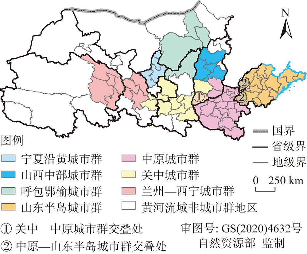
By studying the strategic background of the Yellow River Basin and the development plan of urban agglomerations in the basin, this paper constructs an index system for evaluating ecological protection and economic development that can be applied to a comparative study of urban agglomerations. Based on the index system, this paper analyzes the spatio-temporal characteristics and driving mechanism of the coupling coordination between ecological protection and economic development of seven major urban agglomerations in the basin from 2007 to 2019 by using the coupling coordination degree model, spatial autocorrelation and geographic detectors. The results show that: (1) During the study period, the economic development level of the seven major urban agglomerations has been greatly improved, the progress of ecological protection construction is relatively slow, and the coupling degree between them rises in a fluctuating manner. (2) The eco-economic coordination degree of the urban agglomerations in the upper reaches is lower than that of the middle and lower reaches, and the overall coordination degree is improved to a higher level compared with that of the development mode which was significantly unbalanced in the past. (3) Urban agglomerations in the Yellow River Basin have experienced a transformation from economic development lag to ecological protection lag. (4) The coordination degree between ecological protection and economic development of each urban agglomeration has correlation effect. (5) The coupling mechanism is closely related to people's livelihood development and opening-up, technological innovation and industrial expansion, green development and agricultural construction, basic public service system and so on.
The green transformation of agriculture has become an inevitable choice of rural vitalization and agricultural/rural reforms, therefore, it is urgent to explore the relationship between agricultural production transition and its environmental effects, and fuel the high-quality development. In recent years, the process, spatio-temporal pattern and the mechanism of agricultural production transition and its environmental effects have been intensively investigated and discussed at multiple scales. In order to systematically review the progress and garner the research gaps, literature analysis was used to summarize the state-of-the-arts. Finally, this paper provided an overview of the research progress from the perspective of key elements of agricultural production, and then summarized the research progress of the environmental effects from three aspects - the identification of agricultural environmental problems, the relations between agricultural production transition and non-point source pollution, and agro-ecological efficiency. Future research of agricultural production transition and its environmental effects should be focused on explaining the mutual relations from system science, underlining the regional heterogeneity, enriching the farmland use transition research by applying land system science, and highlighting the micro-mechanism of the environmental response from the perspective of small-holding peasants in China.
This paper analyses the effects of crop specialization on the fertilizer reduction from two dimensions, horizontal crop specialization and vertical division of agricultural production process (vertical specialization). Based on the panel data of 13 major grain producing provinces in China from 1980 to 2018, the effect of crop planting specialization on the reduction of agricultural chemical fertilizer and its mechanism were investigated. The results indicate that, first of all, with the development of horizontal and vertical specialization the fertilizer application intensity reduces and the fertilizer use efficiency increases. The deepening in vertical specialization would enhance the positive effects of expanding horizontal specialization on fertilizer reduction. Secondly, the crop specialization may reduce the fertilizer via two pathways. Pathway 1 is that the increasing horizontal specialization could increase farm operation scale, which contributes to fertilizer reduction. Pathway 2 is that the increasing of horizontal specialization could increase farm operation scale, which further enhances the positive effects of vertical specialization on reduction. However, there is an optimal value for the proper operation scale, and it would be increased with deeper merger of horizontal and vertical specialization. Therefore, it is of great importance to encourage the horizontal and vertical specialization to reduce chemical fertilizer application. It is critical to inspire farmers to expend the operation scale and then further promote the reduction of fertilizer use.
The vulnerability of ecological environment is an important factor restricting the sustainable and high-quality development of economy. Taking 73 cities in the Yellow River Basin as the research objects, we constructed an evaluation index system of the ecological environment vulnerability of the basin from 2005 to 2018. Principal component analysis was used to calculate the ecological environment vulnerability index. According to the natural break point method, the cities were divided into five categories: extreme vulnerability, severe vulnerability, moderate vulnerability, light vulnerability and slight vulnerability. In addition, through spatial correlation analysis, the spatio-temporal evolution characteristics of the ecological environment vulnerability of the study area are revealed. The ecological environmental vulnerability in 2025 is predicted by CA-Markov model. The results showed that: (1) The vulnerability of ecological environment in the upper, middle and lower reaches of the Yellow River shows the distribution characteristics of "low, medium and high", respectively. And there are differences in the variation trend of the ecological environment vulnerability: although there are large differences in the upper reaches, the fluctuations are similar, the fluctuation direction is opposite in the middle reaches, and a downward trend occurred after 2016 in the lower reaches. (2) The vulnerability of ecological environment is spatially correlated. The upper reaches show low-low aggregation, the lower reaches show high-high aggregation, and the spatial correlation in the middle reaches is not significant. (3) It is predicted that the severe vulnerability in the middle reaches will expand in 2025, while the extreme vulnerability in the lower reaches will contract to the central region. The management and protection of the ecological environment in the Yellow River Basin is not a matter of one day, nor can it be completed by one basin alone. The upper, middle and lower reaches should formulate appropriate management and protection measures according to different natural conditions to meet the needs of the overall development.
Nature reserves play important roles in protecting biodiversity and maintaining national ecological security. To enhance the comparability of ecosystem quality within and among nature reserves and to further develop the ecosystem quality assessment method, we propose to use algorithms to quantify key indicator thresholds and ecosystem quality based on the concept of "ideal reference system and key indicators". We used Erguna, Huihe River, and Xilin Gol National Nature Reserves as examples to analyze the ecosystem quality within and among nature reserves. The results showed that: (1) The ecosystem quality in Erguna Nature Reserve was excellent, and its ecosystem quality index was significantly higher than that of Huihe River and Xilin Gol Nature Reserves. (2) There was no significant difference in the ecosystems quality index between the different functional areas of the three national nature reserves. (3) The ecosystem quality indexes of Erguna and Xilin Gol Nature Reserves from 2000 to 2018 showed a significant upward trend, however, there was no significant change in the ecosystem quality index of Huihe River Nature Reserve. The evaluation method proposed in this study can be used to quickly and efficiently evaluate the ecosystem quality and restoration potential of nature reserve, as well as to provide reference for standardized construction and management of nature reserves.
Exploring the evolution of the "ruralism-ecology" system in tourist destinations provided new ideas for understanding the evolution of the structure and function of human-earth areal system. Through constructing a "ruralism-ecology" system resilience measurement and evaluation system in the Dabie Mountains Old Revolutionary Base Area from 2005 to 2019, we discussed the stage, state, path and mechanism of the resilience evolution. The results showed that: (1) The "ruralism-ecology" system of the study areahad undergone an adaptive cycle evolution process of utilization (r), preservation (K), release (Ω), reorganization (α), which corresponded to the period of rapid development of tourist destinations (2005-2009), the mature period of tourist destination development (2010-2012), the transition period of tourist destination development (2013-2016) and the initial stage of tourist destination redevelopment (2017-2019). (2) The county's quantitative structure had undergone a transformation from "lower level to higher level of resilience" in the adaptive cycle. The resilience level of the county-level "ruralism-ecology" system had always maintained a fluctuating upward trend in different adaptive cycle stages. (3) From 2005 to 2019, the driving factors for the resilience evolution of the "ruralism-ecology" system changed from the economic level to the social and cultural level. Under the influence of internal and external factors, the resilience of the "ruralism-ecology" system of tourism destinations was shown in the endowment of rural resources (centripetal cohesion), economic development foundation (core driving force), social security function (important supporting force), and natural environment background (basic binding force), using human behavior as the medium to evolve in interaction and constraints. When the resilience index exceeded the threshold, its core organization would break the original boundary, self-adjust to achieve "path breakthrough", thus entering the next stage of the adaptive cycle, and promoting the sustainable development of tourist destinations.
Ecosystem service is an important basis to ensure rural ecological security, environmental health and sustainable economic development. As an important subject related to rural regional ecosystem and rural economic development, farmers' production and life, as well as their cognition and perception of ecosystem services, have an important impact on the maintenance of ecosystem functions. Based on interviews with farmers and household surveys, this paper explores the changes in farmers' perception of diversity of various ecosystem services from 2008 to 2018 in six rural communities with different development types in Cili county, Hunan province, a key ecological functional area in the hilly and mountainous regions of Southern China. The index model of farmers' perception of diversity of ecosystem services and its influencing factors were established by using multiple linear regression method. On this basis, some suggestions were put forward for synergistic development of both farmers and ecosystem services. The results show that: (1) Farmers' perceptions of various ecosystem services and different regions are different, and the perception of agricultural production leading areas is stronger than that of ecological protection core areas and ecological economic development areas. (2) Farmers' diversity perception and attribute perception of forest land, farmland, garden and wetland ecosystem services are weakened in turn. (3) Natural environment, resource endowment and individual characteristics are important factors affecting farmers' perception of ecosystem services attributes. The results of the study are to maintain regional ecosystem services, and provide reference for improving the well-being of farmers, and promoting the improvement of ecological services and rural coordinated development.
Promoting the construction of ecological civilization is conductive to alleviate the contradiction between ecosystem degradation and the people's high-level requirements for a better life, which leads the regions to achieve a win-win situation between ecological value enhancement and economic growth. This paper quantitatively analyzes the spatial and temporal patterns of ecosystem service values (ESV) in the Pearl River-West River Economic Belt in 2005, 2010, 2015, and 2018 by using the method of the value equivalent factor in unit area, which is modified by biomass and vegetation coverage. Further, this paper constructs a geographically weighted regression (GWR) model based on the STIRPAT model to empirically analyze the spatial heterogeneity and spatial non-stationarity of county economic growth affecting unit area ESV. The results shows that: (1) From the perspective of spatio-temporal variation pattern, the ESV of the study area was 4783.391 billion yuan, 4597.193 billion yuan, 5231.360 billion yuan, and 5074.459 billion yuan in 2005, 2010, 2015, and 2018, respectively, documenting a time-varying trend of decreasing, then increasing, and decreasing again. The contribution of the first classification of land-use types to ESV was ranked as forest land > watershed > grassland > cropland > wetland > desert. From the perspective of spatial trends, the ESV showed an alternative distribution of high and low value areas, and presented a spatial pattern of "low in the west, but high in the east". Some districts and counties located at the border between Guangdong and Guangxi have higher ESV per unit area, which appeared a trend of spreading from east to west. However, ESV in the Pearl River Delta region was hardly affected by the diffusion trend. (2) The number of counties with a significant effect of GDP per capita on ESV per unit area was increasing and concentrated in the eastern, central and northern parts. Among them, the Guangdong section of the Pearl River-West River Economic Belt showed a continuous and significant negative effect. In contrast, the central and northern parts of Guangxi showed a change from negative to positive effect, which is in accordance with the EKC hypothesis. Based on the above results, this paper proposes targeted recommendations. First, further declines in ESV in the Pearl River Delta and its western contiguous parts should be avoided. Second, the central and northern parts of the Pearl River-West River Economic Belt should be given more preferential policies to speed up regional development. Third, the northwestern and southwestern parts should pay more attention to the coordination of economic growth and ecological environment. The results of this paper have important implications to the localized development that balances economic growth and ecological environment.
To improve the evaluation indicators in land planning and tap the potential of ecological construction in agro-pastoral ecotone of Northeast China, the spatiotemporal characteristics of ecosystem service value (ESV) in the region from 2001 to 2018 were interpreted, and three land use options (i.e., prioritized provisioning service, regulating service, and supporting service) were simulated using the multi-objective programming model and CLUE-S model. The results show that: (1) The total ESV increased by 9.69% from 2001 to 2018, with provisioning service, regulating service, and supporting service accounting for 67.25%, 21.88% and 6.74%, respectively. (2) The total ESV increased by 5.84% in the scenario of prioritized supporting service, which was higher than that of prioritized provisioning service (2.66%) and of prioritized regulating service (5.19%). (3) The environmental adaptability of different land use types is different, i.e., in northwestern, southwestern and eastern parts of the study area with more suitability for afforestation and conversion of farmland, the total ESV and supporting service have great potential to improve, while northern and southeastern parts are more suitable for farmland reclamation, which facilitates the improvements of prioritized provisioning service and regulating service. The synergy among different ecosystem services is important in ensuring the security and sustainable development of regional ecology and economy. Aiming to improve ESV with full consideration of policy and environmental adaptability, the land use optimization can provide theoretical basis and practical guidance for the land planning in agro-pastoral ecotone of Northeast China.
Based on the UN 2030 sustainable development goals (UN SDGs) and integrated with ecosystem services, this study established an evaluation index system of sustainable development of villages, farmers and herdsmen for poverty alleviation resettlement, and quantitatively analyzed the changes of Bailang village and farmers and herdsmen before and after the resettlement in the realization of sustainable development goals. The results show that: at the village scale, after the implementation of the resettlement, the sustainable development index values of the immigrated villages under the three goals of poverty eradication (SDG 1), energy sustainability (SDG 7) and sustainable settlements (SDG 11) increased significantly, but the total score of the sustainable development index decreased by 2.91%. The contribution rate of sustainable development index of income, water use and transportation of farmers and herdsmen directly affected by the relocation policy increased from 49.40% to 54.23%, while that of ecosystem related index indirectly affected by the Poverty Alleviation Resettlement decreased from 50.60% to 45.77%. At the scale of farmers and herdsmen, the poverty alleviation resettlement significantly promoted the realization of poverty eradication (SDG 1) and decent work (SDG 8) for relocated farmers and herdsmen, and the sustainable development indicators of indigenous farmers and herdsmen still increased steadily with limited village resources and large population migration. The study provides the guidance for the management and input work after the resettlement of Bailang village, and ideas for the formulation of land use planning and the determination of the number of immigrants in other areas in the future.
With the rapid advancement of urbanization and industrialization in China, the social structure and economic development model of rural areas and the development of spatial systems such as ecological system have changed significantly, followed by the change of land use form in different regions. Thus, revealing scientifically the coupling development relationship between rural spatial restructuring and land use transition, and discussing the coupling mechanism and optimal path are conducive to providing theoretical basis and practical basis for China's rural revitalization and urban-rural integrated development, which is meaningful both in theory and practice. This study used literature review theory to analyze and explain the coupling mechanism and driving factors of rural spatial restructuring and land use transition. The main conclusions are drawn as follows: (1) The reconstruction of rural space is a positive response to the new round of rural transformation and development requirements. As a key development element of rural region, land can adapt to different spatial reconstruction scenes through the multi-dimensional transformation of its utilization forms. (2) Rural spatial restructuring is an important driving force for land use transformation, and it also provides inexhaustible realistic demands for land use transformation. The successful land use transformation is a significant representation of the results of rural spatial restructuring, and there is a coupling interaction between the two. (3) This paper constructs a multi-wheel driving mechanism of their coupling development, the direction of the effect path is different under different action mechanisms. More specifically, spatial planning and policy system design are indispensable constraints and regulation mechanisms of coupled development; the transformation of industrial structure and the change of economic system have obvious driving and catalytic benefits in deepening the coupling relationship between the two. In addition, the coupling relationship between rural spatial restructuring and land use transformation is deeply constrained by the behavior of multiple stakeholders, so the protection and coordination of the ownership rights of relevant stakeholders should run through the coupling development from the end to the end. Finally, establishing the value order of ecological priority is of great significance to the coupling evolution process. (4) In the New Era, it is important to explore the multi-dimensional path of land use optimization to promote coupled development. On the whole, the core values of ecological civilization should be established, spatial planning should be taken as the constrained mechanism, industrial structure upgrading as the induced mechanism, multi-stakeholder coordination as the guaranteed mechanism. Meanwhile, the land policy system mechanism should be innovated. Only in this way can we improve the coupling level and facilitate the implementation of the rural revitalization strategy.
Based on survey data of rice-growing farmers in the Jianghan Plain, this paper examines the impact of agricultural productive services on farmers' farmland quality protection behaviors. Then it reveals the theoretical mechanism and realistic logic of motivating farmers' farmland quality protection behaviors via developing service scale operation. The results indicate that: first, the current adoption rates of typical farmland quality protection measures, including repairing farmland ditches, applying farm manure, adopting soil testing and formula fertilization, and returning straw to the field are 17.79%, 17.31%, 7.89% and 90.69% respectively. Second, agricultural productive services can significantly promote farmers' farmland quality protection behaviors, and the conclusion proves to be robust. Third, after the compulsory measure - returning straw to the field, is eliminated, life-oriented farmers prefer to adopt capital-driven technologies, while production-oriented farmers prefer to apply labor-driven technologies. Fourth, further analyses show that the positive effect of agricultural productive services on motivating cultivated land quality protection behavior is greater in the group of life-oriented farmers than in the group of production-oriented farmers.
With the rapid urbanization, the land utilization rate in the mountainous areas has been increasing. Therefore, we should deepen our understanding of the construction land expansion in mountain cities, so as to carry out more scientific management of land use in mountainous areas. This paper studied the slope gradient effect of construction land growth in Guiyang, a typical mountain city in Southwest China, using digital elevation model (DEM) and construction land datasets of 2000, 2005, 2010, 2015 and 2020, which was integrated with zonal statistics approaches based on spatial statistics unit of kilometer grid and slope section with one degree interval. Combined with the information of construction land density and slope, we propose a novel method to quantify the spatial pattern of construction land climbing. The research was designed to address three research questions: Is there a synergistic relationship between the area of construction land and the average slope of construction land? What are the distribution and change characteristics of construction land density on the slope gradient? What is the relationship between the density of construction land and the heat of construction land climbing? The results showed that: (1) The total area of construction land is positively correlated with the average slope of construction land, both of which increase gradually across the entire study period. However, the average slope of new construction land gradually becomes steeper among four neighboring periods, while the area of new construction land turns from increasing to decreasing, implying that they are not synchronous. (2) The density of construction land in each period decreased with the increase of slope, no matter in one period or in the other four periods. (3) The density of construction land has a significant impact on the heat of construction land climbing, and this influence increases as the average slope of the background ground rises. This paper suggests that the phenomenon of construction land climbing would promote the intensification and compactness of construction land in mountain cities.
As an important policy to promote the development of low-carbon economy in China, the construction of low-carbon pilot cities is particularly important under the dual pressure of carbon emission reduction and economic downturn. Based on the panel data of prefecture-level cities from 2006 to 2018, this paper calculates the urban carbon emission efficiency by using the super-efficiency SBM model, and empirically tests the impact of low-carbon pilot policies on the urban carbon emission efficiency through the difference in difference model. Results show that low-carbon pilot policies can significantly improve urban carbon emission efficiency, which is still true after a series of robustness tests such as PSM-DID. Further research shows that the impact of pilot policies on carbon emission efficiency is heterogeneous, and the policy effect is more significant in the eastern and western regions and non-resource-based regions. The mechanism analysis shows that low-carbon pilot policies can help improve urban carbon emission efficiency by enhancing urban innovation level and adjusting energy structure. The pilot policies in the eastern region play a role mainly through the adjustment of energy structure and the rationalization of industrial structure, while those in the central and western regions affect carbon emission efficiency mainly through technological innovation and the rationalization of industrial structure, respectively. This research provides useful experience and inspiration for strengthening the construction of low-carbon pilot cities and realizing the win-win situation of carbon emission reduction and economic development.
The Three River Headwaters Region is an important barrier for ecological security and one of the most important animal husbandry production bases in China. Under the premise of ensuring sustainable utilization of grassland resources, exploring optimal population capacity is of great significance to the ecological protection construction and sustainable development of this region. In this study, we simulated the theoretical animal carrying capacity of grassland, and then estimated the production value of animal husbandry. We evaluated the optimal population capacity in different periods and spatial differences in population capacity under three scenarios of residents' living standards. The results show that the population capacity of this region was in a surplus state under the three scenarios during the "Tenth Five-Year Plan" period (2001-2005); the population capacity under the current situation and well-off level was still in balance during the "Eleventh Five-Year" (2006-2010) and "Twelfth Five-Year" periods (2011-2015); by the "Thirteenth Five-Year Plan" period (2016-2020), the population capacity of the three scenarios relying only on the production value of animal husbandry was generally overloaded, but there were differences in spatial distribution. The areas with overloaded capacity are mainly distributed in the east of the study region. Under the current situation, well-off, and prosperous living standards scenarios, there are 11 counties, 8 counties, and 2 counties with surplus population capacity, respectively. The regional population structure is adjusted and optimized in accordance with the existing resource distribution and the direction that meets the main functional requirements, which is of great significance to the sustainable development strategy of the region.
Grass-livestock balance management is the key to ensuring the sustainable development of grassland pasture areas. Based on remote sensing images and livestock research data, this study took Gannan as the study area, constructed a month-by-month accounting method for assessing the dynamics of grass-livestock balance, and explored the necessity of optimising the spatial and temporal layout in the process of grass-livestock production management. The main conclusions are as follows: (1) The month-by-month accounting method based on the dynamic relationship between grass production-forage and demand-forage stock realizes the dynamic assessment of seasonal grass-livestock balance. (2) The contradiction of forage balance in Gannan is mainly reflected in the stable demand of livestock for forage and the seasonal fluctuation of natural forage supply, and the month-by-month, township-by-township forage shortage accounting can provide a scientific basis for accurate forage replenishment. (3) The state of forage balance at the state-county-township scale indicates that there is a surplus of forage in the whole Gannan region but some counties and townships are overloaded, which reveals that rotational grazing measures across administrative boundaries may alleviate the seasonal overload. This suggests that rotational grazing across administrative boundaries may alleviate the degradation of grassland caused by seasonal overload in local areas.
It is of great significance to study the spatial and temporal distribution of climate and climate productivity potential under the background of global warming for the development of agriculture and animal husbandry, ecological protection, and sustainable development in the Southwest Tibet Plateau (STP). Based on the Miami and Thornthwaite Memorial models, this paper analyzed the spatial and temporal distribution of climate change, climate productivity potential, and its influencing factors in the STP from 1901 to 2017. The results show that the annual average temperature increased and the annual average precipitation decreased in recent 117 years, and there are obvious periods and abrupt changes in the STP. The temperature productivity potential increased, and decreased from southeast to northwest in space. The precipitation, evapotranspiration, and standard productivity potential have all decreased, showing a decreasing trend from south to north. The standard productivity potential is determined by the precipitation and temperature, and the precipitation is the main limiting factor. In the future,if the climate continues to "warm and dry", the climatic productivity potential of the STP will decrease. To promote the development of the animal husbandry and improvement of ecological environment, in the future, it is better to make efforts on returning grazing land, artificial planting of forage grass, grass importing, barn feeding and breeding, selecting drought-tolerant prolific grass with high productivity, improving the forage yield, striving to achieve the equilibrium of breeding, for the shift from the traditional animal husbandry area to the modern one, and for the realization of sustainable development of local agriculture and animal husbandry and ecological protection in the STP.