The construction of ecological civilization is an important national strategy in China, and the Qinling Mountains play a strategic position in the construction of ecological civilization in China. To clearly understand the existing problems and paths of ecological civilization construction in the Qinling-Daba Mountains, nine well-known researchers from different fields were invited in an interview on cutting-edge research topics in the Qinling Mountains. The interview covered such topics as ecological patterns and geographic processes, scientific investigations, rural revitalization, and water resources protection. The results of the interview show that: to gain a better understanding of the important value of the study area and to carry out the ecological protection and sustainable development in the New Era, it is necessary to understand the ecological and environmental effects of the North-South Transitional Zone of China, reveal the ecosystem service functions, emphasize the pivotal role in maintaining national ecological security, and conduct research on ecological protection and restoration of the Qinling Mountains. It is significant to continuously monitor the ecological functions, build an intelligent monitoring system integrating "Space-Air-Ground", continue to carry out comprehensive scientific investigations, pay attention to major scientific propositions, discover the unique geographical phenomena and laws of the Qinling Mountains, and form a scientific data sharing mechanism and platform to support regional scientific research and decision support. Under the new mobility paradigm, we should look at the resettlement project from a dynamic perspective, focus on the livelihoods of different groups and types of immigrants, and solve immigration problems through a diversified security system. In the context of climate change, it is necessary to attach importance to the response of the Qinling Mountains to climate change and human activities, strengthen the construction of regional transportation infrastructure, find out the law of evolution and changing trend of Qinling Mountains' water resources, and to carry out systematic management to ensure long-term and safe supply of water resources, and promote sustainable social and economic development.
Based on entropy weight-TOPSIS and improved coupling coordination model, the study analyzed the characteristics of regional function transformation and its system coupling coordination degrees in the Qinling-Daba Mountains, and revealed regional function transformation mechanism, and proposed a high-quality development path. The results show that: (1) Since the implementation of China's western development policy, the regional comprehensive functions of the Qinling-Daba Mountains has been optimized. The function index of economic development and social security have been enhanced significantly. However, agricultural production and ecological service function index decreased first and then increased. (2) The coupling and coordination degree between different regional functions presents a progressive evolution rule from low to high level. Regional functions change from agricultural production-oriented to ecological protection-oriented, and then to balanced coordination of various functions. (3) The degree of coupling coordination among different counties has obvious characteristics of "high in the northwest, but low in the southeast". High-value areas are concentrated on the northern foothills of the Qinling Mountains and along the Hanshui River. In the future, by innovating regional coordinated development strategy, constructing a green development system, exploring a high-quality development mode, and building a technological platform, we can enhance the coupling coordination degree of regional function and regional innovation capacity to promote high-quality development of Qinling-Daba Mountains.
Mountain ranges are often natural corridors for wildlife's dispersal and distribution in their trendings. However, due to the habitat fragmentation caused by human activities, the connectivity of mountain corridor has been greatly reduced. Since the 20th century, it is generally recognized that current and previous conservation efforts are often not implemented at scales large enough for long-term persistence of many species and the ecological processes they depend on. Therefore, connectivity conservation of mountains has received increasing attention, and large-scale ecological corridors have been considered to be the best strategy for protecting the long-term biodiversity under climate change. This article reviews the concepts and development history of ecological corridor, the experiences of large-scale ecological corridor practices abroad, and proposes some suggestions for the coming Qinling National Park from the perspective of connectivity conservation. This study points out that large-scale connectivity conservation and ecological corridors are of great significance for the long-term protection of the natural ecosystem of national parks.
Influenced by global change, temperature zone boundaries significantly have moved toward higher latitudes, especially the spatial distribution of subtropical zones is more sensitive to global warming, and the study of the spatial change characteristics of its boundaries is of great significance to understand the potential impact of global changes on natural landscapes. Based on the daily average temperature data from 1960 to 2019 from 74 meteorological stations in and around the Qinling Mountains, the 220-day contour of daily average temperature ≥10 ℃ continuous days with 80% guarantee and the 0 ℃ isotherm in January were selected as the northern boundary indicators of the north subtropics, and the trends of the boundaries of the Qinling climate zone under the background of climate warming in the past 60 years were explored. The results showed that: (1) The number of days with daily average temperature ≥10 ℃ in the study area during the period 1960-2019 showed a significant upward trend, with a change rate of 3.268 d/10 a; the average January temperature showed a weakly significant upward trend, with a change rate of 0.179 ℃/10 a. (2) The northern boundary of the north subtropics in the Qinling Mountains underwent a significant uplift in the past 60 years, with an average height of about 228.89 m. In terms of longitude, the northern boundary of the north subtropics in the middle section from 106°E to 111°E had the greatest change, with a rise of 308.81 m in the 60 years, which is significantly higher than the other two sections in the north and west (165.69 m in the east, 243.33 m in the west, and 267.01 m in the north). (3) The northern subtropical transitional zone of the Qinling Mountains climbed significantly in the 60 years and moved northward. Also, the "north" subtropical zone north of the Qinling Mountains climbed significantly and moved northward; the northern subtropical transitional zone of the Qinling Mountains climbed significantly and moved northward in the past 60 years. After the abrupt change in temperature, the northern subtropical transitional zone extended from the southern slope of the Qinling to the eastern part of the mountains and advanced northward into the Guanzhong Plain, and the role of the southern slope as the boundary between the north subtropical and warm temperate zones was weakened. With the climate warming, the northern subtropical transitional zone may continue to climb to higher elevations, and the northern subtropical transitional zone may be partially or integrally transformed into the north subtropical zone, and the north subtropical zone will be continuously distributed from the southern slope of the Qinling Mountains to the northern slope, and then the northern boundary of the north subtropical zone breaks through the Qinling Mountains.
The Qinling Mountains region, an important water conservation region and ecological function support region, as well as a major ecological barrier in China, plays a critical role in conserving water resources. Based on the data of meteorology and land use, this paper estimates the water yield service in the Qinling region based on InVEST model, and uses spatio-temporal analysis method and geographically weighted regression (GWR) to discuss the variation characteristics and driving factors of water-producing services in the study region from 2000 to 2018. The results show that the average annual water yield in Qinling is 235.16 mm, showing a weak downward trend in 2019 with the highest value (470.17 mm) in 2003 and the lowest (75.57 mm) in 2007. The spatial distribution of water yield gradually decreased from the south to the north with obvious "stepped" distribution characteristics. The change trend of water yield has an insignificant increase and decrease (95.99%), and a small number of regions with a significant increase are formed at higher altitude in the Central and Western Qinling region. There are obvious spatial differences in the fluctuation of water yield in the region, which present a trend of "higher in the north than in the south, mainly with medium and low fluctuation and strong fluctuation in the northwest". The influence of various factors on water production services has obvious spatial heterogeneity. The study region is dominated by precipitation (33.18%), which is concentrated in the southern part of Qinling Mountains with more water production, followed by NPP (17.90%) and actual evapotranspiration (16.71%), which are the main influencing factors in the Central and Northern Qinling Mountains. The research results provide theoretical and technical support for the safety and sustainable utilization of water resources in the Qinling region.
Protecting ecosystems and improving the well-being of people are at the core of achieving the UN 2030 Sustainable Development Goals. Based on the analysis of the spatio-temporal evolution characteristics of ecosystem services and residents' well-being in Qinba Mountains, this paper reveals the spatio-temporal coupling relationship between ecosystem services and residents' well-being using the elastic coefficient. The results showed that: (1) The total water conservation and soil conservation showed a fluctuating decreasing trend, while the total carbon storage showed a slow increasing trend, and the ecosystem services showed different spatial differentiation characteristics from 1990 to 2018. (2) The well-being of residents is on the rise, with an increase of 220%, and the distribution presents a pattern of "high in the south, but low in the north". (3) At the county level, due to the differences in resource endowment and economic level, the three ecosystem services and residents' well-being are obviously not coordinated. Among them, the coupling relationship between water conservation, carbon sequestration services and residents' well-being was dominated by "welfare increase - service decrease", accounting for 88.75% and 62.5%, respectively. However, the coupling relationship between soil conservation services and residents' well-being was dominated by "double increase", accounting for 57.5%. At the same time, the reverse changes of ecosystem services and residents' well-being were mainly distributed in the Hanjiang River valley basin and the central part of the Qinling Mountains. The results of this study can provide a decision-making basis for promoting the coordinated development of ecosystem services and residents' well-being in poverty-stricken mountainous areas.
The new environmental integration of ecological migration is of great significance to the realization of the goal of resettlement. In this study, a semi-structured interview was conducted to investigate 196 ecological migrants who had been resettled nearby in three cities of Shangluo, Ankang and Hanzhong. Through qualitative analysis and qualitative comparative analysis (QCA), this paper makes a correlation analysis between hometown attachment and place integration/alienation of migrants, which shows that migrants' integration into the new environment is a process of hometown-new home interaction. Compared with other types of immigrants, the interaction is more remarkable because of the close placement, including hometown identity, functional dependence and social support, which makes the relationship between hometown and new home more comprehensive. The complexity of the connection between the hometown and the new home is an important factor leading to the alienation of migrants from the new environment. The study suggests that, in addition to addressing the practical difficulties, migrants should be allowed to interact with their hometown and new settlements, and that further policy arrangements should be made for the interaction in order to gradually realize the migrants' psychological and social multi-level integration into the new environment.
As a national strategy, the policy of rural revitalization is of great significance. Rural social space united by social progress and spacial progress is not only a new perspective but also an important way to promote rural revitalization in mountainous areas. Based on field investigation in three counties in Shaanxi province, namely, Zhashui, Shangzhou, and Taibai, the participants, composition and evolution types of rural social space in mountainous areas are analyzed. The conclusions can be drawn as follows: (1) Four participants are included in the process of shaping rural social space, namely, government, rural elites, outside investors and local farmers. Among them, the government plays a leading role; rural elites play a connecting role; the outside investors are the new promoters in rural areas. Local farmers are the base of rural social space. (2) The rural social space in mountainous areas is composed of physical space, action space and institutional space. (3) There are six basic forms of rural social spacial evolution in mountainous areas: production, separation, transfer, expansion, compression, and vanishing. Finally, it is considered that the rural society in mountainous areas should be guided to develop healthily by establishing social space that rooted in rural areas.
The concept of resilience provides a new perspective for the study of rural development in poor mountainous areas of the Qinling Mountains. Research on the potential of rural revitalization from the perspective of resilience is of great significance for improving the endogenous development momentum of poor mountainous villages and realizing effective rural revitalization. This paper takes Shangluo, a mountainous city of Qinling as a case. Based on the theoretical construction, the paper establishes a poverty-stricken mountainous village resilience evaluation system to measure the resilience index, and uses spatial principal component analysis to identify the restoration ability. Based on the key influencing factors of power, the classification system of the potential types of rural revitalization in the three districts and counties is proposed. The research results show that: (1) The resilience index of the three districts and counties of Shangluo is in a concentrated distribution, and the resilience is generally low. (2) Environmental and economic factors play a decisive role in the resilience of rural communities. (3) The rural revitalization potential of the three districts and counties can be divided into four types: balanced development potential area, agricultural leading potential area, agricultural tourism concurrently operating potential area, and geographical environment restricted potential area. Targeted measures for revitalization strategy are proposed according to their resource endowments and current development conditions.
This paper introduces Bourdieu's capital theory and constructs a multiple capitals conceptual model. Taking S village at the northern foot of the Qinling Mountains in Xi'an as an example, this paper makes a qualitative research and visual analysis on the process and mechanism of space production and shrinkage under the comprehensive influence of different types of capitals. The results show that: (1) The three circulation of economic capital promotes the commodification of physical space in S village. The difference of financial capital owned by merchants leads to the differentiation of economic class and spatial differentiation in the village, and the entry of foreign economic capital is likely to induce social risk. (2) The change of structural social capital, such as the social network interwoven by the new-born business relationship, kinship and geographical relationship, leads to the hybridity of social space and the differentiation of local identity in S village. The decline of cognitive social capital, such as social trust, leads to the interior movement of villagers' communication space and promotes the formation of a new space governance order. (3) Embodied cultural capital such as merchants' personal taste creates diversified cultural space, and institutionalized cultural capital such as collective titles given by the government promotes the formation of professional village brand of agritainment. (4) Under the guidance of meta capital, three major tourism projects in the village were demolished, and S village changed from continuous space reproduction to space shrinkage. (5) Natural monopoly rent, the advantage of small-scale collective action, indirect control and direct influence of meta capital, and dual locking effect constitute the mechanism of space production and shrinkage in S village.
How to integrate poverty alleviation with Rural Revitalization Strategy with the help of tourism development is an important issue in the development of rural areas in the new era. In order to achieve this goal, we need to fully understand the unbalanced and inadequate development problems left over in the past tourism poverty alleviation, adhere to the rural orientation, establish the equal "mutual feeding" relationship between urban and rural areas, clarify the dialectical relationship between traditional village protection and rural revitalization, clarify the multiple logical relationship between rural nature, rural tourism and rural revitalization, and distinguish the regional differences and development stages. It is necessary to coordinate multiple subjects, respect villagers' rationality, enhance the citizenship of rural residents, and explore innovative development paths such as slow tourism, digital economy and rural tourism integration.
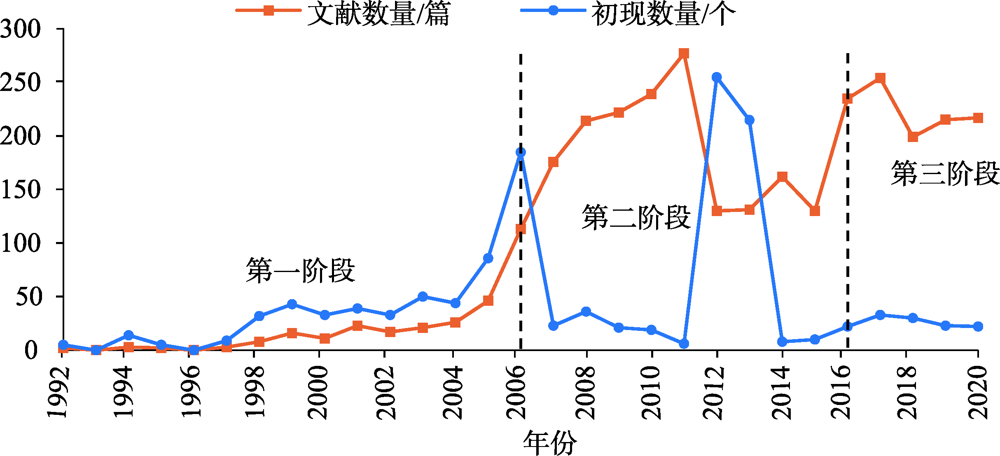
This paper summarizes the research process of rural tourism in China through systematic literature review, which contains three stages: primary application research (1992-2005), diversified expansion research (2006-2015), and integration deepening research (2016-), as well as analyzes the background and research value orientation of each stage. Based on the analysis of knowledge map by CiteSpace, it reveals the changing process and characteristics of research topics. Combining the rural revitalization strategy and tourism development needs in the New Era, the research expounds the basic characteristics of rural tourism, constructs the research framework of rural tourism in the New Era, puts forward the main scientific issues, and proposes the research trends and academic innovations of rural tourism research. Moreover, the research emphasizes that rurality and recreation constitute the fundamental characteristics of rural tourism. Future research should focus on the national strategy and high-quality development requirements of the New Era, as well as keeping up with the international academic frontiers. Meanwhile, based on the local practice of rural tourism research in China, relevant research should concentrate on the "five-sphere integrated plan" basic framework for rural tourism, taking industry, ecology, culture, governance, and livelihood as the core elements. Under this research framework, it is essential to focus on the rural area system with its complexity and key tourism scientific issues, to strengthen research platforms and professional talents, to integrate multidisciplinary theories and technology methods, as well as to reinforce the ideas of data-driven and science-technology energization. It is also necessary to reveal the process, patten, mechanism, and rule of rural revitalization pushed by rural tourism in a deep-going way, to explore the development model and path of rural tourism revitalization with distinct Chinese characteristics, to continuously promote the deepening of theoretical research, practical application innovation and the development of rural tourism discipline, besides, to improve the academic research, innovation ability, service value, and internalization level of rural tourism.
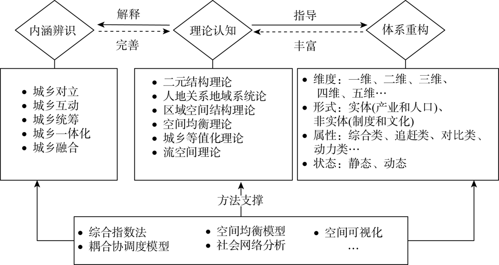
The scientific evaluation of urban-rural integration is the core content of urban-rural integration, and it is the foundation for establishing and improving the institutional mechanism of urban-rural integration. Based on the logical line of "connotation identification-theoretical analysis-system reconstruction", this paper carries out the review of urban-rural integration evaluation including concept connotation, theoretical basis, evaluation index, evaluation method, evaluation scale, spatio-temporal differentiation, and mechanism analysis. At present, the academic understanding of the connotation of urban-rural integration is basically the same. The evaluation index selection of urban-rural integration shows multidimensional and multi-attribute characteristics, but the index system construction has not broken through the static characteristics. Quantitative evaluation method is relatively simple. Generally, current research still remains at the macro scale, but lacks quantitative research from a micro perspective and comparative studies of different fusion modes. The spatial and temporal differentiation pattern and its mechanism of urban-rural integration need to be further deepened. Finally, this paper puts forward five prospects: (1) strengthening the construction of basic theory system and perfecting system research framework; (2) optimizing the multidimensional evaluation index system and identifying the development model of urban-rural integration; (3) deepening the flow mechanism of urban and rural elements and promoting the balanced development of urban and rural space; (4) strengthening the exploration of micro-scale details and improving the promoting mechanism of urban-rural integration; (5) strengthening the empowering role of the digital economy and innovating the development mechanism of high-quality urban-rural integration.
On the basis of constructing the urban-rural integration evaluation index system suitable for the county scale including economic development, social life and ecological environment, this paper analyzed the urban-rural integration at the county scale in the Capital Region from 1995 to 2018 by using the Theil index and the ESDA method. The study also identified the types of urban-rural integration and proposed differentiated rural revitalization paths. The results indicate that: (1) The urban-rural integration level at the county scale in the Capital Region, with the turning point of 2000, experienced a "U"-shaped change process of decreasing first and then increasing. The overall level of urban-rural integration tended to increase. The regional gap in urban-rural integration level increased first and then decreased, and the overall trend tended to shrink. The contribution rate to the overall urban-rural integration level difference between the two regions (Beijing and the three cities around Beijing) was slightly higher than the internal difference between the two types of regions, the internal difference in the three cities around Beijing was the main reason for the internal differences between the two types of regions. The internal differences between Zhangjiakou and Baoding were the main reasons that led to the overall difference in the level of urban-rural integration in the three cities around Beijing, and the internal difference in Baoding was dominant. (2) The number of low-level fusion zones was decreasing, and the high-level fusion zones continued to increase. The "core-edge" structure of high and low level urban-rural integration areas was prominent, and has experienced a dynamic evolution stage of "single-group single-core" to "multi-groups multi-cores" to "single-group multi-cores". The level of urban-rural integration showed a significant spatial positive correlation, and the agglomeration increased first and then decreased. The hot spots of urban-rural integration areas were clustered in Beijing, and the cold spots and sub-cold spots were arranged in a ring or strip shape outside the central urban district of Baoding, and its state was getting milder. The "cold and hot" spatial pattern of urban-rural integration level was closely related to the geographical environment and socio-economic development background. (3) The area around the Capital Region could be divided into five types of urban-rural integration areas: urban-rural integration leading demonstration area, urban-rural integration advance development area, urban-rural integration optimization and upgrading area, urban-rural integration transformation and promotion area and urban-rural integration underdeveloped area. According to the characteristics of each type of district, this paper proposed differentiated rural revitalization implementation paths.
Various types of national development zones have acted as test fields of China's reform and opening-up and an important carrier of rapid economic development over the past 40 years. The spatial distribution of national development zones has always been a hot topic in domestic and international academic communities. Spatial evolution is an important basis for understanding the spatial evolution of Chinese economy, but little attention was paid to it before. Using nearest neighbor analysis, kernel density estimation and geodetector methods, this article summarized the spatial evolution process and driving factors of national development zones. The main conclusions of the study are as follows. The spatio-temporal evolution of national development zones has gone through three stages: pilot phase, steady phase and accelerated phase. Policies and governance have been promoted from pilot areas to the rest of the country. In terms of spatial distribution, the evolution process is from the east coast to the river, border, then inland, from Eastern China to the central and western regions, and from provincial capitals to prefecture-level cities. The evolution is the result of the interaction of factors such as distance, city level, economic development level and openness. Among them, city level, openness and economic development level are the core driving factors, while distance and economic density are the secondary driving factors. Different types of national development zones have generalities and differences due to their function and orientation.
The improvement of a system of natural resource asset rights is the basis and prerequisite for carrying out unified registration of natural resources and confirmation of rights, advancing the accounting of natural resource assets, and compiling the balance sheet of natural resources. Based on the principal-agent theory, this article attempts to construct a new era natural resource asset property rights system with Chinese characteristics in accordance with the logic of "institutional failures-lag in market construction-inefficient government regulation-hierarchical agency-three-power separation design". The study found that the failure to arrange the property rights of natural resources assets, the lag in the construction of the property rights market, the weakening of the principal-agent mechanism, and the imbalance of resource supervision are the main obstacles to the effective use of natural resources. Establishing a "Three Rights Separation" property rights system for natural resource assets, through the coupling of the functional decomposition of the property rights of natural resource assets and the management mechanism, is conducive to clarifying relationships between the rights, responsibilities, and benefits of owners, agents and users of natural resources.
The rise of sharing accommodation is an important driving force for the structural reform of the supply side of the urban tourism industry. It is of great significance to scientifically understand its spatio-temporal pattern and driving factors for the development of urban tourism. Based on the information on sharing accommodation listings in nine national-level central cities of China through the Airbnb website, this study uses the spatial analysis methods such as standard deviational ellipse and DBSCAN clustering algorithm to analyze the spatial and temporal evolution pattern of houses, and to explore influencing factors of the spatial distribution of housing listings with the geodetector. The results show that: (1) From 2015 to 2017, the spatial pattern of sharing accommodation in national central cities changed rapidly, and the overall situation was in a period of rapid development. From 2017 to 2019, the spatial pattern tended to be stable, which was in a steady growth period. (2) The development of sharing accommodation in national central cities has a spatial and temporal dependence, and the clustering centers continue to increase with time. The sharing accommodation in most cities gradually expands around the city. The spatial and temporal differences between clustering centers in the three regions of the Eastern, Central and Western China are obvious. (3) From the perspective of development direction and the number of high-level clustering centers, the sharing accommodation in national central cities includes four-sided and "single-to-multiple" directions, as well as "0-1", "X-1" and "1-X" evolutionary models. (4) Business, transportation, population and other factors have a greater impact on the spatial pattern of sharing accommodation in national central cities, and there are significant differences in the intensity and significance of the influencing factors between regions and cities. Among them, catering, leisure, shopping, residential quarters, etc. have become the main factors driving the formation of sharing accommodation space.
This study uses the 16 groups (87 protected areas in 10 countries) of China involved in the Global List of Transboundary Nature Reserves published by UNEP-WCMC in 2007 as data sources. By analyzing the laws of its spatial distribution pattern, the evaluation system's overall framework is constructed from four aspects: ecological integrity, governance structure matching, institutional and cultural differences, spatial distance, and transportation. It is further decomposed into nine indicators to establish an indicator system of the potential for cross-border cooperation between border protected areas and Chinese nature reserves. Delphi and AHP are used to quantitatively and empirically analyze relevant indicators. The results show that the most concentrated distribution of protected areas in the border area is adjacent to Heilongjiang province and Russia. The Himalayas and Karakorum Mountains are areas with good ecosystem integrity that bear essential ecological functions and are protected by neighboring countries. Five regions with high potential for future cross-border cooperation were initially selected: China (Xingkai Lake)-Russia, China (Xishuangbanna)-Laos, China (Tashkurgan)-Pakistan, China (Qomolangma)-Nepal and India, China (Baitou Mountain)-DPRK and Russia. This study put forward the difficulties and recommended cross-border cooperation measures and can provide a method reference for cross-border cooperation of China's border protection areas.