Due to the particularity of natural environment and geographical location, the human settlement environment of the Yellow River Basin is in a complex process of constant changes and is always facing severe challenges. The coupling process of human environment space with natural and social elements originates from the dynamic, comprehensive and systematic adaptation mechanism presented in the process of human-land relationship change, so revealing the system adaptation mechanism is the key to solve the human environment dilemma in the Yellow River Basin. Therefore, based on the perspective of "locality and adaptability", this paper invited experts and scholars from Qinghai, Gansu, Ningxia, Inner Mongolia, Shaanxi, Shanxi, Henan and Shandong along the Yellow River and other provinces. They interpreted the characteristics of human settlements in the Yellow River Basin from the perspectives of natural geography, social economy, urban and rural development, and heritage protection, and sought sustainable strategies to adapt to China's new urbanization path. The main points are stated as follows: On the whole, the adaptability of human settlements in the study area has multi-scale spatial correlation and historical geographic dependence. The Yellow River Basin has an important ecological function, but the natural environment in different regions is facing such problems as land salinization, soil erosion and pollution, etc., so it is necessary to promote the greening of human-land coupling relationship. The Yellow River Basin, especially the cities along the upper reaches of the river, have distinct characteristics of openness, ethnic cultural diversity and integration. Due to the complex natural environment, caves and other special settlements have been formed in the middle and upper reaches of the Yellow River. In the process of rapid urbanization, they are faced with transformation and disappearance, retaining the cultural genes of traditional settlements, and it is urgent to classify and treat them differently to promote their healthy evolution. The internal and external radiation drive of urban agglomeration in the Yellow River Basin is the foundation of high-quality development throughout the river basin, and the optimization and upgrading of urban structure is an important way to promote high-quality development. To achieve sustainable development, scientific and technological innovation and industrial structure transformation and upgrading are also needed.
The Hehuang Valley in the upper reaches of the Yellow River is one of the areas with a long history of human activities, and it is the westernmost part of cultivated land reclamation along the Yellow River. The reconstruction of settlements and cultivated land has practical significance for the study of human activities and global change in this basin. In this paper, a database of settlements and cultivated land in the Hehuang Valley in the late Northern Song Dynasty (1117) was established by combing a large number of historical documents. Based on the spatial distribution of settlements, the grid model was used to reconstruct the cultivated land pattern of the study area with an accuracy of 1 km×1 km. The results show that: (1) The settlements in the Hehuang Valley in the upper reaches of the Yellow River in the late Northern Song Dynasty are concentrated in alluvial and proluvial plains along the main stream of the Yellow River and Huangshui River with relatively low altitude and gentle slope, and the "City" is mainly distributed in the mountain pass in the relatively low altitude area, highlighting its defense function; "States and Castles" are mostly distributed along rivers with relatively flat terrain and relatively geo-safe; however, "Villages" are scattered along the tributaries of rivers, showing the characteristics of disorderly development. (2) The total cultivated land area in the Hehuang Valley is estimated to be about 304.67 km2, with only 16.16% of the grids distributed with cultivated land and only 24.16% of the grids with the highest reclamation rate, among which 74.06% are distributed in the Huangshui Valley and 25.94% along the main stream of the Yellow River, indicating that cultivated land reclamation in the late Northern Song Dynasty is mainly concentrated in the Huangshui River Basin. (3) From the altitude of settlement distribution, 78.09% of the cultivated land grids are distributed in the area of flat terrain with water below 2600 m above sea level, and 21.91% of the grids are distributed in the shallow mountains between 2600 m and 3200 m, indicating that the cultivated land range was not large at that time, and the altitude greatly restricted the expansion of cultivated land, which was mainly distributed in areas with superior irrigation conditions. (4) Rebuilding the spatial pattern of cultivated land based on settlement accords with the fact that cultivated land is distributed with settlements, which is more reliable.
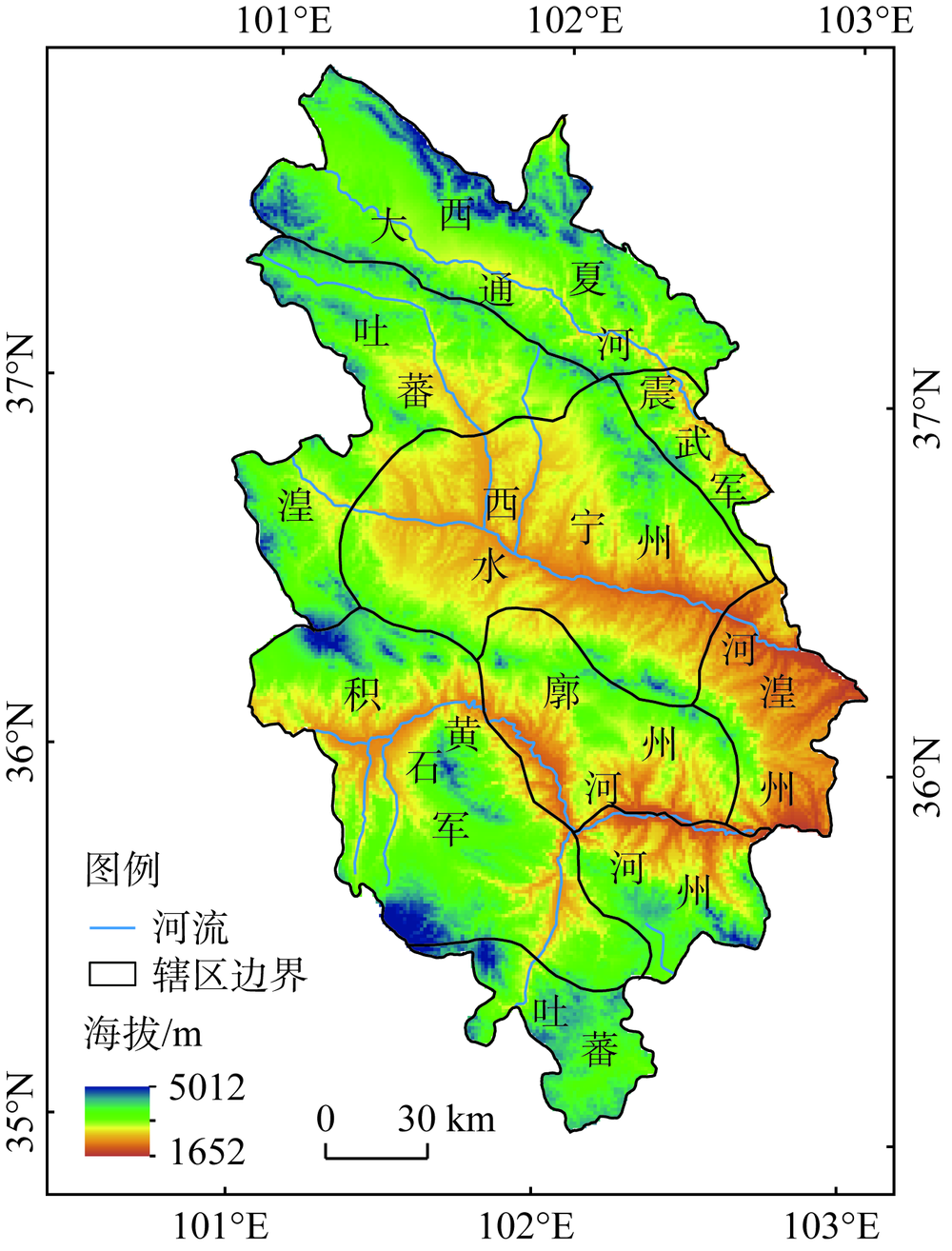
The Wuding River Basin, located in the Loess Plateau of the middle reaches of the Yellow River, is a typical transitional zone and ecologically fragile area in history. Based on the analysis of the historical development process of urban pattern and the coupling relationship between human and land in this process, this paper puts forward the countermeasures and suggestions for the future urban development and ecological protection of the basin in combination with the current situation of urban development. The main findings are as follows: the development and evolution of the urban hub area in the basin was bow shaped in the Tang Dynasty and before, when the natural conditions were better, and the urban spatial layout was mainly based on natural factors; the hub area after the Tang Dynasty presented a triangle pattern, and the urban spatial layout was mainly based on human factors; the contemporary urban pattern of the basin inherited the context of historical development, but the driving force of urban development was mainly based on resources along the Great Wall. The human activities have an impact on the vegetation coverage in some areas; at the same time, the ecological protection policies, such as returning farmland to forests, wind prevention and desertification control, have exerted positive effects. It is suggested that the development of the river basin should be reasonably determined and concentrated around the main cities and towns in combination with the national strategic positioning and regional ecological environment bearing capacity. In addition, the ecological barrier and key prevention and control areas are constructed with the river as the backbone.
In the changing history of the Yellow River, the third major diversion has led to a sudden northward migration, which radically changed the urban natural and human environment in the flood area and is an ideal research area of the human-earth coupling system. We used a combination of horizontal cross-sectional methods, mathematical statistics and GIS tools to explore the number, spatio-temporal variability characteristics and urban adaptations of the cities flooded by the Yellow River. The results show that: (1) The overflowing of the Yellow River during the seven river-flowing periods gave rise to 29 affected cities. (2) The affected cities were widely distributed in general, but relatively concentrated in the top of the alluvial fan formed by the bursting of the Yellow River, the low-lying Jizhong Plain and the confluence of the Yellow River and Yuhe River. (3) The cities flooded by the Yellow River mainly showed four types of urban adaptability: direct destruction, dismantling, relocation and reinforcement, in which the type of the relocation of floods is dominant, accounting for 45%. (4) The imperial court decision and city scale were important human factors affecting the spatial differentiation and urban adaptability in the sudden disaster environment of the Yellow River. The affected cities in the flooded areas are important models of local conservation significance and sustainable development evolution, which is recommended that they should be included in the national strategy of "Ecological Protection and High-quality Development of the Yellow River Basin" and as an important area for telling the story of the Yellow River.
The spatial pattern evolution of the cities in the historical Yellow River Basin will help us understand the characteristics and development context of human settlements, which plays a key role in ecological protection and urban development in the Yellow River Basin today. This article uses the time series data of cities (BC763-AD1911) in the CHGIS database of Harvard University, the elevation data of STRM, the regional data of nine major basins in China, and the historical population data. It studies the spatio-temporal pattern evolution of cities in the Yellow River Basin, as well as the influencing factors. The results show that: (1) The changes in the number of cities can be divided into five stages. (2) The first level continous stable region includes the high-density urban area in northern Henan with present Anyang as the center, high-density urban area in Guanzhong with present Xi'an as the center, and the secondary high-density area with Jinan, Taiyuan and Luoyang as the center. The second level continuous stable region includes five important city belts, namely, Weihe River city belt, Fenhe River city belt, northern foot city belt of central Shandong mountainous region, eastern foot city belt of Taihang Mountains and Grand Canal city belt. (3) The average distance of city gravity migration is 32 km, and the average distance of population gravity migration is 95.78 km. The distribution of cities and population is closely related. (4) Natural factors such as temperature and precipitation, elevation, distance from the rivers, downstream avulsions of the Yellow River, as well as human factors such as wars, capital transfer and canals, had jointly influenced the spatial and temporal distribution of cities in the Yellow River Basin.
To explore the sustainability of regional development, on the basis of the system coupling collaborative evaluation system, a comprehensive index system suitable for large regions and multi-cities is constructed, which can evaluate the construction of ecological civilization and urbanization. With the help of this index system, the ecological civilization construction and the coupling and coordinated development of urbanization in 80 cities at and above the Yellow River Economic Belt from 2008 to 2016 were evaluated from two dimensions of time and space. Then, the exploratory spatial data analysis method is used to analyze the spatial pattern and spatial relation characteristics of the coupling coordination level in the research area. The empirical results show that: (1) From 2008 to 2016, the ecological civilization construction in the Yellow River Economic Belt did not achieve significant results, and the pressure was still very high, which proves the necessity and urgency of ecological protection and high-quality development in the Yellow River Basin. The overall urbanization had improved, but the entire development rate was still too slow. There was no obvious leading city in both aspects, and the spatial difference was distinct. (2) From 2008 to 2016, the ecological civilization construction and urbanization in the cities of the Yellow River Economic Belt were in a low degree of coupling, the coordination degree was slightly unbalanced, and the ecological civilization construction generally lagged behind the urbanization development. The spatial pattern was characterized by obvious spatial heterogeneity and administrative orientation. (3) The coordination degree of ecological civilization and urbanization in the research area showed a certain spatial dependence and spatial connection, and the coordination degree showed a certain spatial spillover effect, and the geographical adjacent areas were more susceptible to the influence of regions with high coordination degree.
Under the dual background of the "Yellow River Strategy" and the promotion of supply-side structural reform, it is important to investigate spatial structure of urban commerce of capital cities along the Yellow River so as to promote the high-quality development of the Yellow River Basin's urban economy. This paper takes the provincial capital cities along the Yellow River as an example, analyzes their commercial space structure through the kernel density estimation and the standard deviation ellipse method, and explores the level of commercial space service capabilities through overlay analysis. The results show that: (1) The total sales of social retail products per capita in the urban area shows an increasing trend from the upper to the lower reaches of the Yellow River Basin. Along the river, Jinan is a typical active consumer city. (2) The commercial spatial structure of the capital cities along the Yellow River shows beaded type, single core type, basic network type and mature network type. (3) The more mature the urban commercial spatial structure becomes, the stronger its spatial service capability is. Jinan has the most significant commercial spatial service capacity, and Zhengzhou has the worst. The research results can provide a scientific reference for the high-quality development of the Yellow River Basin and land spatial planning in the new period.
Correctly handling the relationship between land intensive use efficiency and ecological well-being performance is a special essential prerequisite for promoting ecological protection and high-quality development in the Yellow River Basin. Based on the stochastic frontier analysis model in the form of a translog production function that includes a time trend variable, we measure the land intensive use efficiency and ecological welfare performance of 57 cities in the Yellow River Basin from 2008 to 2017. With the help of a coupling model, distribution dynamic theory and geographical detector tools, in the perspective of cities and provincial levels, the dynamic evolution of the coupling degree between them is described, and the coupling mechanism and driving factors are clarified. The results show that: (1) The land intensive use efficiency of 57 cities has basically remained stable and improved slightly over time, provincial capital cities have gradually formed the first echelon of land intensive use efficiency, but the ecological welfare performance has shown a trend of declining fluctuations. The degree of coupling keeps a high level, taking 2012 as the boundary, it has undergone the evolution process of "decline-rise". (2) The degree of coupling development between cities is uneven, because the coefficient of variation of most provinces is increasing, nearly one fifth of the cities belong to the type of "low level coupling" with low development degree and low coordination degree, although more than half of the cities have achieved the relative synchronization between development and coordination. What's more, the degree of coupling generally presents a spatially differentiated pattern of "northeast-southwest", the center of gravity moves to the southwest as a whole, and its evolution is mainly to maintain the original type and transform to adjacent types. (3) As for the driving factors, the explanatory power of economic dimensions speak louder than that of the natural and social dimensions, that is to say, economies are the leading factors of coupling degree, while social factors and natural factors play roles of support and foundation respectively. The interaction between factors shows the two-factor enhancement and non-linear enhancement effects, and social factors are the main interaction objects.
Urbanization is an important factor affecting the pattern of regional ecological security. Clarifying the relationship between urbanization and ecosystem services can provide decision-making references for promoting ecological protection and high-quality development in the Middle Yellow River. Based on the analysis of the spatio and temporal patterns of urbanization and ecosystem services in the Middle Yellow River from 2000 to 2018, the study uses the coupling coordination degree model to analyze the spatio-temporal characteristics of the coupling relationship between urbanization and ecosystem services in the study area. The results show that between 2000 and 2018, the comprehensive urbanization level increased by 72.24%, and the spatial distribution was generally "high in the south and low in the north", with economically developed counties decreasing outward. Grain production, water resource conservation, soil conservation and carbon sequestration services all showed an increasing trend in different spatial distribution trends. Generally, the degree of coupling coordination between grain production, water resource conservation, soil conservation and carbon sequestration services and comprehensive urbanization level is on the rise, but the degree of coupling coordination in the Fenhe-Weihe Plain is low, while that in economically developed counties is high.
Based on the calculation of the ecosystem service supply, demand and coordination degree in the Yellow River Basin, we comprehensively analyzed the co-variation trend of land spatial pattern and coordination degree of supply-demand in this basin. Then, correlation analysis and quantile regression were used to analyze the influence of various land spaces on the coordination degree of supply-demand, and its regional heterogeneity. The results showed that: (1) Land spatial pattern, and supply and demand of ecosystem services showed significant spatio-temporal differentiation. The upper and middle reaches of the river and the lower reach are areas with densely distributed and significantly increased productive land and living land from 2000 to 2015. The increase in supply of ecosystem service was consistent with the distribution of cultivated land and forest land, and that in demand of ecosystem service was consistent with the distribution of population density and construction land. (2) The spatio-temporal change of the coordination degree was affected by the evolution of land spatial pattern. The influence of the land spaces on the coordination degree of supply and demand was different under different coordination levels, and there was significant regional heterogeneity in different regions. (3) According to different land spaces that had an impact on the coordination degree, different areas should rationally lay out land space and formulate development policies to promote effective ecosystem management.
The Yellow River Basin is an important ecological barrier and economic zone in China, and its upstream water-conserving areas play a decisive role in the sustainable ecological development of the Yellow River Basin. Therefore, scientific coordination of urban and rural development and reasonable delineation of urban growth boundary (UGB) are of great significance for ecological protection and high-quality urban development in the Upper Yellow River Basin. This paper takes Linxia, a typical prefecture-level city in the upper reaches of the Yellow River, as the research object, and assesses its ecological quality based on land use and related remote sensing data using remote sensing ecological index (RSEI) and ecological sensitivity analysis. On this basis, the future urban growth boundary development with and without ecological quality assessment conditions is analyzed in combination with CA-Markov comparison. The results show that: (1) From 2005 to 2015, the overall ecological environment of the study area was poor and decreased year by year, and the ecological quality (RSEI) result dropped to the lowest (0.38) in 2015. Meanwhile, the ecological sensitivity changed from moderate to low sensitivity. (2) The urban expansion area increased by 6.04 km2, and the scale of urban construction land in 2030 obtained by CA-Markov simulation was 95.88 km2, which exceeded the planned area by 3.2 km2, and the urban expansion was not effectively restrained. (3) Simulation of RSEI-CA-Markov shows that the urban construction land in 2030 is 90.36 km2, which is smaller than the planned government planning area of 3.3 km2, and meets the requirements of urban sustainable development. Based on this, the designated UGB has stronger urban management capabilities. The delineation of UGB in the ecologically fragile area in the Upper Yellow River is conducive to guiding and realizing sustainable urban development, which can also provide reference for the sustainable development of other ecologically fragile cities in China.
Based on the analysis of the coupling mechanism of ecological protection and high-quality development, the provincial unit is taken as the research unit to evaluate the coupling coordination degree of ecological protection and high-quality development of the Yellow River Basin, compared with the Yangtze River Economic Belt. Finally, the panel VAR model is used to quantitatively analyze the interactive response relationship between ecological protection and high-quality development in the Yellow River Basin. The main conclusions are as follows: (1) During the study period, both the ecological protection index and the high-quality development index of the Yellow River Basin showed an increasing trend, and the overall pattern of the middle and lower reaches was higher than that of the upper reaches. (2) The coupling coordination degree of ecological protection and high-quality development in the Yellow River Basin showed an overall increasing trend. Among them, the coupling coordination degree from 2003 to 2011 was less than 0.5, which was an antagonistic stage; in 2012-2017, the coupling coordination degree is between 0.5-0.7, which belongs to the run-in stage. The metropolis in the Yellow River Basin presents a spatial pattern of downstream > middle reaches > upstream, with the highest coupling coordination between Shandong and Shanxi at the provincial level, and the lowest coupling coordination between Ningxia and Qinghai. (3) The ecological protection index of the Yellow River Basin is slightly higher than the national average. The high-quality development index and the coupling coordination degree are lower than the national average. The ecological protection index of the Yellow River Basin in the early stage (2003-2009) is lower than that of the Yangtze River Economic Belt, while it is higher in the later period (2010-2017). The high-quality development index and coupling coordination degree are lower compared with the Yangtze River Economic Belt in all the years. (4) Both the ecological protection and high-quality development of the Yellow River Basin have positive progressive effects and inertial development characteristics, and their effects on themselves are declining year by year, and the degree of attenuation of high-quality development is more obvious. The ecological protection and high-quality development of the Yellow River Basin play a positive role in promotion, but due to the overall low level of ecological protection and high-quality development and uneven internal development, the mechanism of action of the two is not significant.
The ecological environment in the upper reaches of the Yellow River is fragile, and ecological and environmental problems such as soil erosion and land degradation continue to threaten the health of the ecosystem and the quality of human settlements. In order to explore the safety status of the ecological environment in the ecological function area in the upper reaches of the Yellow River, this article quantitatively analyzed the spatio-temporal distribution of ecosystem service value and ecological risk index based on land use data in 2000, 2010 and 2018, with the help of ecosystem service models and ecological risk models, and built four types of ecological divisions through z-score standardized methods. The results show that: (1) During the study period, various land use types changed to varying degrees. Among them, construction land increased most significantly due to the transfer of cultivated land and grassland, with an increase area of 118 km2 and a growth rate of 46.36%. (2) The overall service value of the study area has a small degree of change, the ecosystem services are mainly regulating services and the grassland provides the highest value. High service value areas are mainly distributed in areas with high vegetation coverage such as the southwestern part of Linxia prefecture and Zhuoni county. (3) The ecological risk level of the study area is generally low, showing the characteristics of "high in the north and south, but low in the middle". The low and low ecological risk areas account for more than 76% of the total area. (4) Little changes have taken place in the four types of ecological zoning, indicating that the ecological zoning is in a relatively stable state of development. The continuity of the spatial distribution of different ecological zones is poor, among which high ecosystem service value-high ecological risk area (I) is the most typical. Constructing ecological zoning through ecosystem services and ecological risks (value-risk) can provide a theoretical basis for coordinating the relationship between humans and land in the region and clarifying future development directions.
Improving urban resources and environmental efficiency is of great significance to the high-quality development of the river basin. This article uses the SBM super-efficiency model based on undesired output and the Malmquist-Luenberger index, the resources and environmental efficiency of cities above prefecture level in the Yellow River Basin in 2000, 2005, 2010, 2015 and 2017 were measured and calculated, and their spatial and temporal characteristics were analyzed in combination with the kernel density function. Finally, the Tobit model is used to measure the main influencing factors of urban resources and environmental efficiency, which is expected to provide a scientific reference for improving the quality and efficiency of the resources and environment of the study area. The results show that the urban resources and environmental efficiency of the Yellow River Basin has generally shown a U-shaped change trend, and the overall level is not high. The number of non-DEA effective cities is much larger than that of DEA effective cities. Urban total factor productivity has shown a downward trend, but efficiency changes and pure technical efficiency changes show an improvement trend; industrial structure and government intervention are positively correlated with resources and environmental efficiency. The level of economic development, urbanization, energy consumption and environmental governance have a negative effect on the resources and environmental efficiency.
Eco-efficiency is the comprehensive embodiment of regional development quality, and the synthetic reflection of coordination degree between socio-economic system and environmental system. Taking the Yellow River Basin as the research area, this study explored the spatio-temporal evolution and driving forces of eco-efficiency of resource-based cities. At first, eco-efficiencies of 37 resource-based cities from 2003 to 2017 were evaluated, using the TOPSIS method. Then, the spatio-temporal changing trends were revealed through the Theil index, the Global Spatial Autocorrelation analysis and the Hotspot analysis. At last, the key driving factors of eco-efficiency change were explored by the Panel Tobit Regression model. The results showed that: (1) On the whole, the eco-efficiency of resource-based cities in the Yellow River Basin stabilized first and then increased during 2003 and 2017, with 2007 as the turning point. However, the quantity and rate of eco-efficiency growth varied considerably among resource-based cities. The two indexes of downstream cities were significantly higher than those of middle and upstream cities, and these two indexes of regenerative cities were significantly higher than those of growing cities, grow-up cities and recessionary cities. (2) The eco-efficiency gap between resource-based cities decreased slightly at first and then increased continuously during 2003 and 2017. Meanwhile, the eco-efficiency spatial distribution pattern of resource-based cities evolved from random state to aggregate state. Specifically, the low-value agglomeration areas were distributed at the junction of Shanxi and Henan provinces at first, and then moved upstream to the central and northern parts of Shanxi province. The high-value agglomeration areas, however, remained consistently in Shandong province, which is located in the lower reaches of the Yellow River. (3) In general, industrial transformation, scientific and technological innovation, infrastructure improvement and location conditions had significant positive effects on the improvement of eco-efficiency in the study area. However, export-oriented economy, resource dependence and environmental regulation had significant inhibitory effects, and urbanization, industrialization and foreign capital utilization had no significant impact. It is worth noting that the driving factors of eco-efficiency were heterogeneous across different types of resource-based cities, which means that different resource-based cites should take different measures to improve their eco-efficiencies.
Based on the concept and connotation of the main function optimization of the river basin, this paper systematically analyzes various main function goals of the basin, and establishes the main function water resource allocation mechanism based on the evaluation index system of the main function of the basin, which is solved by genetic algorithm. The multi-objective optimization model obtained 4 types of water resource allocation plans for 9 provincial-level regions in the Yellow River Basin in 2017. The research results show that: (1) The main functions of the river basin to realize the water resource allocation mechanism makes the Yellow River Basin the largest possible water saving of 2.301 billion m3. (2) The water resources allocation mechanism for the main functions of the basin has brought about 434.448 billion yuan in production function increments, and 99.135 billion yuan in ecological function value increments, which can feed 81.948 million more people. (3) Reducing agricultural water use in Ningxia and Shandong and industrial water distribution in Inner Mongolia is crucial to the optimal distribution of water resources in the study basin.
Changes in the water and sediments of the Yellow River are associated with ecosystem security and quality development throughout the basin. It is of great significance to quantify the contribution of climate change and human activities to the reduction of runoff in order to analyze the causes of water and sediment changes in the Yellow River. Due to different research scales and research methods, the factors and influence degree of runoff variation vary greatly. Therefore, based on the same time scale, this paper uses MK trend test and Double Mass Curve method to systematically analyze the changing trend of hydrological elements in four typical basins (Huangfuchuan, Kuye River, Wuding River and Yanhe River) in the middle reaches of the Yellow River from 1960 to 2015. The Budyko water heat balance equation is used to clarify the role of climate change and human activities in the water and sediment change of the basin. The results showed that the runoffs in Huangfuchuan, Kuye River, Wuding River and Yanhe River basins all decreased significantly from 1960 to 2015 (P<0.01), and the runoffs in 1979 and 1999 experienced sudden changes without significant variations in precipitation. Compared with the base period (1960-1979), the contribution rate of climate change to runoff reduction in the P2 period (1980-1999) reached 64%-76%; with the large-scale implementation of the project of returning farmland to forestland and grassland, human activities in the P3 period (2000-2015) have become the main influencing factor leading to runoff reduction, with a contribution rate of 71%-88%.