
JOURNAL OF NATURAL RESOURCES >
Ecological risk and regional differentiation in the Qinghai-Tibet Plateau
Received date: 2020-07-03
Revised date: 2020-11-18
Online published: 2022-02-28
Copyright
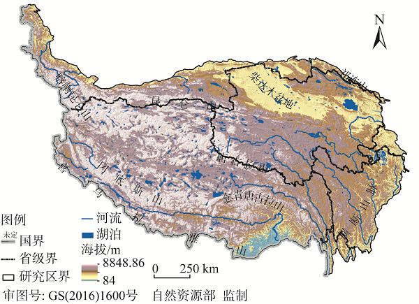
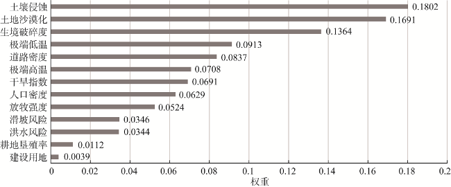
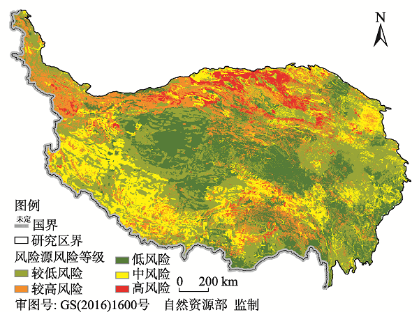
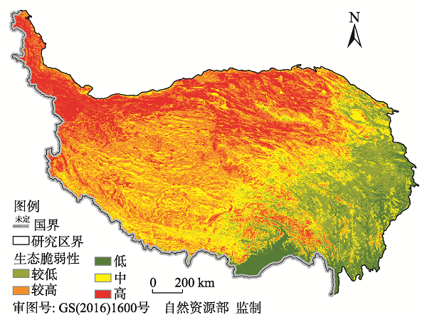
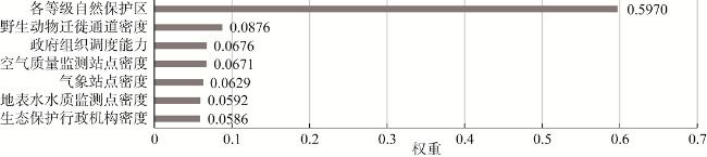
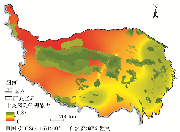
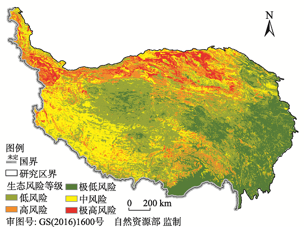
Under the background of global change, the ecosystem of the Qinghai-Tibet Plateau has been affected and threatened by both nature and human activities, and the ecological risks are intensifying. The Qinghai-Tibet Plateau is a relatively independent geographic unit with a high average altitude and complex and diverse landforms. Its fragile alpine ecosystem is extremely sensitive to global climate change. In recent years, the population of the plateau has increased and the process of urbanization has accelerated, the scale and intensity of human activities have increased significantly, and ecological risks have increased. At present, the research results of ecological risk assessment are mainly found in local areas of the Qinghai-Tibet Plateau. This article, aiming at understanding the source of ecological risks, analyzes the spatial distribution of risks and their causes. The ecological risk assessment of the entire plateau is expected to provide references for the identification, management and early warning of regional ecological risks. We establish an ecological risk assessment index system for the study area, which includes 13 ecological risk source indicators, 10 ecological vulnerability indicators, and 7 ecological risk management capability indicators. Then we select the official remote sensing product data with a high spatial resolution, according to the characteristics of the data which are divided into numerical and non-numerical data. Using ArcGIS 10.2 to normalize the numerical data, according to the contribution rate to ecological risk, the non-numerical data are graded, and the ecological risk evaluation optimization model is used to comprehensively evaluate the ecological risk of the plateau. The results showed that: overall ecological risk of the study area is relatively low, with low and very low ecological risk areas accounting for 55.84%, extremely high risk areas being only 7.19%, high risk areas 11.95%, and medium ecological risk areas 25.02%, and the extremely low and low ecological risk areas account for more than half of the plateau area; medium ecological risk areas are mainly distributed in areas with high intensity of human activities. The impact of human activities on the eco-environment of the Qinghai-Tibet Plateau cannot be ignored; the extremely high-risk areas and medium-risk areas form a "C"-shaped pattern; the low-risk areas in the hinterland of the plateau have higher altitudes, severe cold climates, and fragile eco-environments, but the strengthening of ecological management measures has greatly reduced the ecological risk in the study area. The overall ecological risk of the Qinghai-Tibet Plateau is mainly controlled by natural factors, and the impact of human activities on the eco-environment cannot be ignored. The establishment of national nature reserves or national parks to protect the ecological environment can greatly reduce its ecological risks. It is necessary to pay special attention to areas with high intensity of human activities on the plateau, where their ecological risks have reached a medium intensity. Creating a new pattern of harmonious coexistence between humans and nature, and avoiding excessive human intervention in the eco-environment on the Qinghai-Tibet Plateau is an important way to reduce ecological risks in the future.
Key words: Qinghai-Tibet Plateau; ecological risk; regional differentiation
LIU Fei , LIU Feng-gui , ZHOU Qiang , CHEN Qiong , WANG Sheng-zhen , GUO Rong , MA Wei-dong . Ecological risk and regional differentiation in the Qinghai-Tibet Plateau[J]. JOURNAL OF NATURAL RESOURCES, 2021 , 36(12) : 3232 -3246 . DOI: 10.31497/zrzyxb.20211216
表1 青藏高原生态风险评估指标的数据来源Table 1 Data sources of ecological risk assessment indicators on the Qinghai-Tibet Plateau |
表2 青藏高原非数值类评估指标风险等级Table 2 Risk level of non-numerical assessment indexes in Qinghai-Tibet Plateau |
| 序号 | 评估指标 | 风险等级 | ||||
|---|---|---|---|---|---|---|
| 低 | 较低 | 中 | 较高 | 高 | ||
| 1 | 建设用地 | — | 农村居民建设用地 | 城镇建设用地 | 其他建设用地 | — |
| 2 | 土地沙漠化 | — | — | 裸土地 | 沙地 | 戈壁 |
| 3 | 坡向 | — | 阴坡 | 半阴坡 | 半阳坡 | 阳坡 |
| 4 | 植被类型 | 森林 | 灌丛 | 草地 | 高山植被 | 裸地 |
| 5 | 政府组织调度能力 | 省政府驻地 | 市政府驻地 | 县政府驻地 | 乡镇政府驻地 | 村委会 |
| 6 | 各等级自然保护区 | 国家级 | 省级 | 地级 | 县级 | — |
注:“—”表示无分级类型。 |
| [1] |
彭建, 党威雄, 刘焱序, 等. 景观生态风险评价研究进展与展望. 地理学报, 2015,70(4):664-677.
[
|
| [2] |
马克明, 孔红梅, 关文彬, 等. 生态系统健康评价: 方法与方向. 生态学报, 2001,21(12):2106-2116.
[
|
| [3] |
陈辉, 刘劲松, 曹宇, 等. 生态风险评价研究进展. 生态学报, 2006,26(5):1558-1566.
[
|
| [4] |
IPCC. Climate Change 2007: Impacts, Adaptation and Vulnerability. Contribution of Working Group II to the Fourth Assessment Report of the Intergovernmental Panel on Climate Change. Cambridge, UK and New York, USA: Cambridge University Press, 2007.
|
| [5] |
秦大河, 罗勇, 陈振林, 等. 气候变化科学的最新进展: IPCC第四次评估综合报告解析. 气候变化研究进展, 2007,3(6):311-314.
[
|
| [6] |
蔡金鑫. 全球气温或提前升高1.5 ℃. 生态经济, 2018,34(12):2-5.
[
|
| [7] |
|
| [8] |
|
| [9] |
巩杰, 赵彩霞, 谢余初, 等. 基于景观格局的甘肃白龙江流域生态风险评价与管理. 应用生态学报, 2014,25(7):2041-2048.
[
|
| [10] |
颜磊, 许学工. 区域生态风险评价研究进展. 地域研究与开发, 2010,29(1):113-118, 129.
[
|
| [11] |
曾建军, 邹明亮, 郭建军, 等. 生态风险评价研究进展综述. 环境监测管理与技术, 2017,29(1):1-5, 10.
[
|
| [12] |
刘迪, 陈海, 史琴琴, 等. 黄土丘陵沟壑区生态风险时空动态及其风险分区: 以陕西省米脂县为例. 自然资源学报, 2019,34(9):2012-2025.
[
|
| [13] |
|
| [14] |
|
| [15] |
|
| [16] |
|
| [17] |
|
| [18] |
|
| [19] |
|
| [20] |
|
| [21] |
殷贺, 王仰麟, 蔡佳亮, 等. 区域生态风险评价研究进展. 生态学杂志, 2009,28(5):969-975.
[
|
| [22] |
陈峰, 李红波, 张安录. 基于生态系统服务的中国陆地生态风险评价. 地理学报, 2019,74(3):432-445.
[
|
| [23] |
|
| [24] |
张雅洲, 谢小平. 基于RS和GIS的南四湖生态风险评价. 生态学报, 2015,35(5):1371-1377.
[
|
| [25] |
王艳分, 倪兆奎, 李晓秀, 等. 洞庭湖生态风险评价及阶段性特征. 中国环境科学, 2019,39(1):321-329.
[
|
| [26] |
|
| [27] |
许开鹏, 王晶晶, 迟妍妍, 等. 基于综合生态风险的云贵高原土地利用优化与持续利用对策. 生态学报, 2016,36(3):821-827.
[
|
| [28] |
王洁, 摆万奇, 田国行. 土地利用生态风险评价研究进展. 自然资源学报, 2020,35(3):576-585.
[
|
| [29] |
张天华, 王彤, 黄琼中, 等. 西藏高原拉萨河流域生态风险评估. 生态学报, 2018,38(24):9012-9020.
[
|
| [30] |
赵丹阳, 曾永年. 青海高原东部河湟谷地生态风险评价: 以海东市为例. 中国沙漠, 2016,36(4):1190-1197.
[
|
| [31] |
|
| [32] |
周伟, 曾云英, 陈绍军, 等. 西藏高原基础设施建设规划的生态风险评价: 以西藏山南地区为例. 自然灾害学报, 2007,16(4):21-26.
[
|
| [33] |
张镱锂, 李炳元, 郑度. 论青藏高原范围与面积, 地理研究, 2002,21(1):1-8.
[
|
| [34] |
姚檀栋. 青藏高原水—生态—人类活动考察研究揭示“亚洲水塔”的失衡及其各种潜在风险. 科学通报, 2019,64(27):2761-2762.
[
|
| [35] |
朱立平, 鞠建廷, 乔宝晋, 等. “亚洲水塔”的近期湖泊变化及气候响应: 进展、问题与展望. 科学通报, 2019,64(27):2796-2806.
[
|
| [36] |
|
| [37] |
孙志忠, 马巍, 穆彦虎, 等. 青藏铁路沿线天然场地多年冻土变化. 地球科学进展, 2018,33(3):248-256.
[
|
| [38] |
姚檀栋, 邬光剑, 徐柏青, 等. “亚洲水塔”变化与影响. 中国科学院院刊, 2019,34(11):1203-1209.
[
|
| [39] |
刘迪, 陈海, 耿甜伟, 等. 基于地貌分区的陕西省区域生态风险时空演变. 地理科学进展, 2020,39(2):243-254.
[
|
| [40] |
樊艳红, 王春明, 王德光. 基于生态环境安全评价的广西生态文明建设研究. 南宁师范大学学报: 自然科学版, 2019,36(4):76-80.
[
|
| [41] |
陶晓燕. 资源枯竭型城市生态安全评价及趋势分析: 以焦作市为例. 干旱区资源与环境, 2014,28(2):53-59.
[
|
| [42] |
韦晶, 郭亚敏, 孙林, 等. 三江源地区生态环境脆弱性评价. 生态学杂志, 2015,34(7):1968-1975.
[
|
| [43] |
宋建波, 武春友. 城市化与生态环境协调发展评价研究: 以长江三角洲城市群为例. 中国软科学, 2010, (2):78-87.
[
|
| [44] |
陈锐杰. 基于概率分布的青藏高原极端温度事件变化分析. 西宁: 青海师范大学, 2018.
[
|
| [45] |
王静爱, 左伟. 中国地理图集. 北京: 中国地图出版社, 2010: 346.
[
|
| [46] |
徐庆勇, 黄玫, 刘洪升, 等. 基于RS和GIS的珠江三角洲生态环境脆弱性综合评价. 应用生态学报, 2011,22(11):2987-2995.
[
|
| [47] |
吴小君, 方秀琴, 任立良, 等. 基于随机森林的山洪灾害风险评估: 以江西省为例. 水土保持研究, 2018,25(3):142-149.
[
|
| [48] |
郝国栋. 基于随机森林模型的商南县滑坡易发性评价. 西安: 西安科技大学, 2019.
[
|
| [49] |
扈秀宇, 秦胜伍, 窦强, 等. 基于GIS和随机森林模型的泥石流敏感性分析: 以吉林省洮南市北部山区为例. 水土保持通报, 2019, 39(
[
|
| [50] |
缪亚敏. 滑坡危险度评价中的负样本采样方法研究. 南京: 南京师范大学, 2016.
[
|
| [51] |
彭建, 谢盼, 刘焱序, 等. 低丘缓坡建设开发综合生态风险评价及发展权衡: 以大理白族自治州为例. 地理学报, 2015,70(11):1747-1761.
[
|
| [52] |
华青措. 阳坡—阴坡高寒嵩草草甸地上生物量、多样性及土壤因子变化. 草学, 2017, (4):22-25.
[
|
| [53] |
戚伟, 刘盛和, 周亮. 青藏高原人口地域分异规律及“胡焕庸线”思想应用. 地理学报, 2020,75(2):255-267.
[
|
| [54] |
吴成启, 唐登勇. 近50年来全球变暖背景下青藏高原气温变化特征. 水土保持研究, 2017,24(6):262-266, 272.
[
|
/
| 〈 |
|
〉 |