
JOURNAL OF NATURAL RESOURCES >
Study on the spatial correlation between traditional villages and poverty-stricken villages and its influencing factors in China
Received date: 2020-04-23
Revised date: 2020-12-02
Online published: 2022-02-28
Copyright
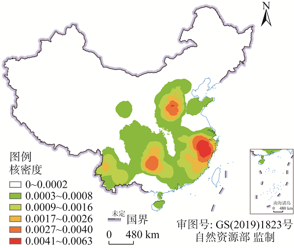
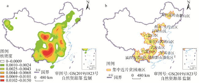
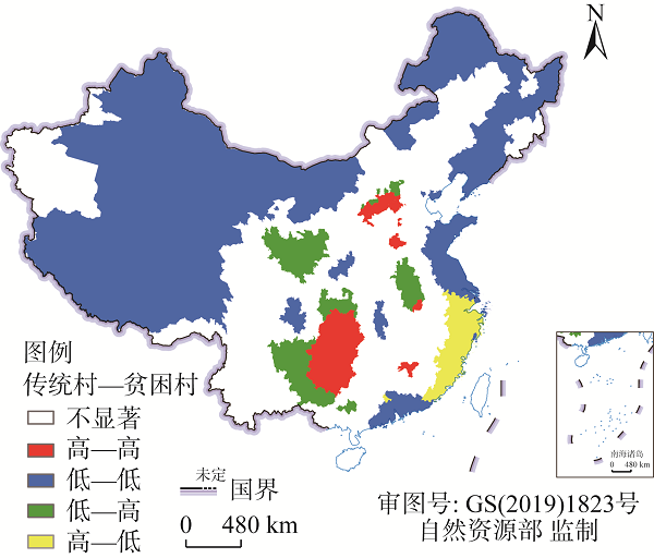
Based on the five lists of traditional villages published by the Ministry of Housing and Urban-Rural Development (China) and the poverty-stricken villages in poverty alleviation for a whole village during the 12th Five-Year Plan period (2011-2015), this paper analyzes the distribution pattern and spatial correlation of Chinese traditional villages and poverty-stricken villages, and discusses the relationship between the spatial correlation and regional natural environment and socio-economic factors. The results show that: (1) In terms of the spatial distribution relationship between traditional villages and poor villages, the regions with high-density traditional villages and high-density poor villages are mainly distributed in provincial-level regions of Hubei, Hunan, Guizhou, the border of Guangxi, the north of Shanxi, which are mostly contiguous poverty-stricken mountainous areas. Regions with low-density traditional villages and low-density poor villages (low-low type) are generally located in coastal and border areas, while low-high type areas are generally located in provincial border areas; the villages of high-low type are mainly distributed in Zhejiang and Fujian provinces with high economic development level. (2) Taking the low-low type regions as the reference, the low-high type areas are significantly negatively correlated with transport accessibility and regional economic development, and positively correlated with population, temperature, elevation and slope, which indicates that the risk of poverty is higher in areas with larger population and worse natural conditions (higher temperature, gradient and elevation). (3) Compared with low-low type areas, high-low type areas have a significant positive correlation with urbanization rate, which indicates that areas with higher density of traditional villages tend to have higher urbanization rate, and the urbanization process has no serious impact on the protection of traditional villages. There is a significant negative correlation between transport accessibility, population and high-high type areas. (4) The influence of different slope, temperature and precipitation areas on the spatial correlation of traditional villages and poor villages is different. It is necessary to make strategies for poverty alleviation and development of traditional villages according to local conditions. This paper aims to provide some guidance and support for China's poverty alleviation and rural revitalization based on the protection and development of traditional villages.
Key words: traditional village; poor village; spatial correlation; influencing factor; China
CHEN Hui-ling , XU Jian-bin , YANG Wen-yue , CAO Xiao-shu . Study on the spatial correlation between traditional villages and poverty-stricken villages and its influencing factors in China[J]. JOURNAL OF NATURAL RESOURCES, 2021 , 36(12) : 3156 -3169 . DOI: 10.31497/zrzyxb.20211211
表1 影响因素的解释变量描述Table 1 The description of explanatory variables of influencing factors |
| 解释变量 | 测度指标 | 均值 | 标准差 | |
|---|---|---|---|---|
| 社会经济维度 | 交通通达性 | 不同类型道路里程之和与面积的比值/(m/km2) | 434.58 | 693.48 |
| 城镇化率 | 第二三产业人口所占比例/% | 21 | 40.9 | |
| 人口 | 县域人口/万 | 64.47 | 72.69 | |
| GDP | 财政收入/亿元 | 394.11 | 892.94 | |
| 自然环境维度 | 气温 | 2015年平均气温/℃ | 12.04 | 6.39 |
| 降水量 | 2015年平均降水量/mm | 9621 | 6122 | |
| 地形 | 县区范围内各5 km栅格点的平均高程/m | 944.84 | 1274.38 | |
| 县区范围内各5 km栅格点坡度的中位数/(°) | 2.78 | 2.48 |
表2 不同交通可达性与城镇化水平的各类型县区分布Table 2 The counties in different zones of transport accessibility and urbanization level in China (个) |
| 交通可达性/(m/km2) | 高—高 | 低—低 | 低—高 | 高—低 | 城镇化率/% | 高—高 | 低—低 | 低—高 | 高—低 |
|---|---|---|---|---|---|---|---|---|---|
| <100 | 43 | 190 | 64 | 5 | <20 | 48 | 162 | 67 | 8 |
| 100~200 | 66 | 64 | 70 | 23 | 20~40 | 77 | 188 | 98 | 49 |
| 200~300 | 15 | 54 | 27 | 19 | 40~60 | 18 | 106 | 14 | 33 |
| 300~400 | 8 | 47 | 16 | 15 | 60~80 | 7 | 53 | 3 | 30 |
| >400 | 18 | 194 | 7 | 72 | 80~100 | 0 | 42 | 0 | 14 |
表3 不同人口与GDP水平的各类型县区分布Table 3 The counties in different zones of population size and GDP level in China (个) |
| 人口/万人 | 高—高 | 低—低 | 低—高 | 高—低 | GDP/亿元 | 高—高 | 低—低 | 低—高 | 高—低 |
|---|---|---|---|---|---|---|---|---|---|
| <20 | 20 | 166 | 22 | 8 | <100 | 77 | 163 | 83 | 13 |
| 20~60 | 92 | 161 | 84 | 62 | 100~200 | 49 | 107 | 59 | 23 |
| 60~100 | 28 | 114 | 35 | 39 | 200~300 | 11 | 64 | 31 | 20 |
| 100~140 | 5 | 58 | 25 | 17 | 300~400 | 4 | 54 | 7 | 17 |
| >140 | 5 | 50 | 18 | 8 | >400 | 9 | 161 | 4 | 61 |
表4 不同气温和降水量范围内各类型县区分布Table 4 The counties in different zones of the temperature and slope in China (个) |
| 气温/℃ | 高—高 | 低—低 | 低—高 | 高—低 | 降水/mm | 高—高 | 低—低 | 低—高 | 高—低 |
|---|---|---|---|---|---|---|---|---|---|
| <0 | 0 | 60 | 0 | 0 | <450 | 2 | 202 | 36 | 0 |
| 0~6 | 1 | 135 | 15 | 0 | 450~900 | 40 | 193 | 55 | 0 |
| 6~12 | 20 | 124 | 54 | 0 | 900~1350 | 38 | 58 | 60 | 9 |
| 12~18 | 115 | 144 | 88 | 105 | 1350~1800 | 58 | 68 | 23 | 65 |
| >18 | 14 | 87 | 27 | 29 | >1800 | 12 | 28 | 10 | 60 |
表5 不同高程和坡度范围内各类型县区分布Table 5 The counties in different zones of the elevation and slope in China (个) |
| 高程/m | 高—高 | 低—低 | 低—高 | 高—低 | 坡度/(º) | 高—高 | 低—低 | 低—高 | 高—低 |
|---|---|---|---|---|---|---|---|---|---|
| <100 | 11 | 187 | 33 | 35 | <5 | 14 | 236 | 33 | 23 |
| 100~400 | 22 | 118 | 11 | 55 | 5~10 | 32 | 192 | 39 | 26 |
| 400~700 | 32 | 60 | 16 | 35 | 10~15 | 75 | 51 | 61 | 53 |
| 700~1000 | 40 | 17 | 17 | 9 | 15~25 | 29 | 63 | 45 | 32 |
| >1000 | 45 | 167 | 107 | 0 | >25 | 0 | 7 | 6 | 0 |
表6 以传统村密度低—贫困村密度低类为参照的多项式Logit回归结果Table 6 The results of multinomial logit model ("traditional villages of low density - poor villages of low density" as reference) |
| 变量 | 高—高类模型 | 低—高类模型 | 高—低类模型 |
|---|---|---|---|
| 交通通达性 | -0.99** | -2.804*** | 1.158 |
| 城镇化率 | -0.165 | 0.077 | 0.361* |
| 人口 | -0.961*** | 2.124*** | -0.3 |
| GDP | 0.049 | -10.328*** | 0.046 |
| 气温 | 1.962*** | 3.482*** | -2.02*** |
| 降水量 | -0.692** | -2.012*** | 2.933*** |
| 高程 | -0.977** | 0.652** | -11.479*** |
| 坡度 | 1.334*** | 0.795*** | 3.862*** |
| N | 1017 | ||
| Pseudo R2 | 0.652 | ||
| Chi2 | 1047.68 | ||
注:*、**、***分别表示在1%、5%、10%的统计水平上显著。 |
| [1] |
龙花楼, 刘彦随, 邹健. 中国东部沿海地区乡村发展类型及其乡村性评价. 地理学报, 2009,64(4):426-434.
[
|
| [2] |
|
| [3] |
聂晓英, 石培基, 张学斌, 等. 西北干旱区乡村性评价及驱动机制研究: 以甘肃武威为例. 地理科学, 2017,37(4):585-594.
[
|
| [4] |
刘沛林, 于海波. 旅游开发中的古村落乡村性传承评价: 以北京市门头沟区爨底下村为例. 地理科学, 2012,32(11):1304-1310.
[
|
| [5] |
汪德根, 吕庆月, 吴永发, 等. 中国传统民居建筑风貌地域分异特征与形成机理. 自然资源学报, 2019,34(9):1864-1885.
[
|
| [6] |
刘彦随. 中国新时代城乡融合与乡村振兴. 地理学报, 2018,73(4):637-650.
[
|
| [7] |
吴文智. 旅游地的保护和开发研究: 安徽古村落(宏村、西递)实证分析. 旅游学刊, 2002,17(6):49-53.
[
|
| [8] |
李咪, 芮旸, 王成新, 等. 传统村落的空间分布及影响因素研究: 以吴越文化区为例. 长江流域资源与环境, 2018,27(8):1693-1702.
[
|
| [9] |
吕龙, 黄震方, 李东晔. 乡村文化记忆资源的“文—旅”协同评价模型与应用: 以苏州金庭镇为例. 自然资源学报, 2020,35(7):1570-1585.
[
|
| [10] |
何静, 汪侠, 刘丹丽, 等. 国家级贫困县旅游发展与多维贫困的脱钩关系研究: 以西南地区为例. 地理研究, 2019,38(5):1189-1207.
[
|
| [11] |
杜国明, 赵雅倩, 李冬梅. 耕地资源富集区县域贫困格局及其影响机制: 以黑龙江省兰西县为例. 地理科学, 2019,39(4):671-679.
[
|
| [12] |
刘春腊, 徐美, 刘沛林, 等. 传统村落文化景观保护性补偿模型及湘西实证. 地理学报, 2020,75(2):382-397.
[
|
| [13] |
李伯华, 尹莎, 刘沛林, 等. 湖南省传统村落空间分布特征及影响因素分析. 经济地理, 2015,35(2):189-194.
[
|
| [14] |
王新歌, 席建超, 孔钦钦. “实心”与“空心”: 旅游地乡村聚落土地利用空间“极化”研究: 以河北野三坡旅游区两个村庄为例. 自然资源学报, 2016,31(1):90-101.
[
|
| [15] |
刘大均, 胡静, 陈君子, 等. 中国传统村落的空间分布格局研究. 中国人口·资源与环境, 2014,24(4):157-162.
[
|
| [16] |
余亮, 孟晓丽. 基于地理格网分级法提取的中国传统村落空间分布. 地理科学进展, 2016,35(11):1388-1396.
[
|
| [17] |
佟玉权. 基于GIS的中国传统村落空间分异研究. 人文地理, 2014,29(4):44-51.
[
|
| [18] |
陶伟, 陈红叶, 林杰勇. 句法视角下广州传统村落空间形态及认知研究. 地理学报, 2013,68(2):209-218.
[
|
| [19] |
刘沛林. 古村落文化景观的基因表达与景观识别. 衡阳师范学院学报, 2003,23(4):1-8.
[
|
| [20] |
胡最, 刘沛林, 曹帅强. 湖南省传统聚落景观基因的空间特征. 地理学报, 2013,68(2):219-231.
[
|
| [21] |
康璟瑶, 章锦河, 胡欢, 等. 中国传统村落空间分布特征分析. 地理科学进展, 2016,35(7):839-850.
[
|
| [22] |
何仁伟, 陈国阶, 刘邵权, 等. 中国乡村聚落地理研究进展及趋向. 地理科学进展, 2012,31(8):1055-1062.
[
|
| [23] |
王永明, 王美霞, 吴殿廷, 等. 贵州省乡村贫困空间格局与形成机制分析. 地理科学, 2017,37(2):217-227.
[
|
| [24] |
刘艳华, 徐勇. 中国农村多维贫困地理识别及类型划分. 地理学报, 2015,70(6):993-1007.
[
|
| [25] |
李佳, 成升魁, 马金刚, 等. 基于县域要素的三江源地区旅游扶贫模式探讨. 资源科学, 2009,31(11):1818-1824.
[
|
| [26] |
|
| [27] |
|
| [28] |
梁晨霞, 王艳慧, 徐海涛, 等. 贫困村空间分布及影响因素分析: 以乌蒙山连片特困区为例. 地理研究, 2019,38(6):1389-1402.
[
|
| [29] |
文琦, 施琳娜, 马彩虹, 等. 黄土高原村域多维贫困空间异质性研究: 以宁夏彭阳县为例. 地理学报, 2018,73(10):1850-1864.
[
|
| [30] |
|
| [31] |
刘彦随, 周扬, 刘继来. 中国农村贫困化地域分异特征及其精准扶贫策略. 中国科学院院刊, 2016,31(3):269-278.
[
|
| [32] |
武鹏, 李同昇, 李卫民. 县域农村贫困化空间分异及其影响因素: 以陕西山阳县为例. 地理研究, 2018,37(3):593-606.
[
|
| [33] |
张超, 杨秉赓. 计量地理学基础. 2版. 北京: 高等教育出版社, 1991.
[
|
| [34] |
曹小曙, 徐建斌. 中国省际边界区县域经济格局及影响因素的空间异质性. 地理学报, 2018,73(6):1065-1075.
[
|
| [35] |
杨忍. 基于自然主控因子和道路可达性的广东省乡村聚落空间分布特征及影响因素. 地理学报, 2017,72(10):1859-1871.
[
|
| [36] |
卢松, 张小军, 张业臣. 徽州传统村落的时空分布及其影响因素. 地理科学, 2018,38(10):1690-1698.
[
|
| [37] |
赵雪雁, 马艳艳, 陈欢欢, 等. 干旱区内陆河流域农村多维贫困的时空格局及影响因素: 以石羊河流域为例. 经济地理, 2018,38(2):140-147.
[
|
/
| 〈 |
|
〉 |