
JOURNAL OF NATURAL RESOURCES >
Simulation research of urban development boundary based on ecological constraints: A case study of Nanjing
Received date: 2020-05-29
Request revised date: 2020-08-13
Online published: 2022-01-28
Copyright
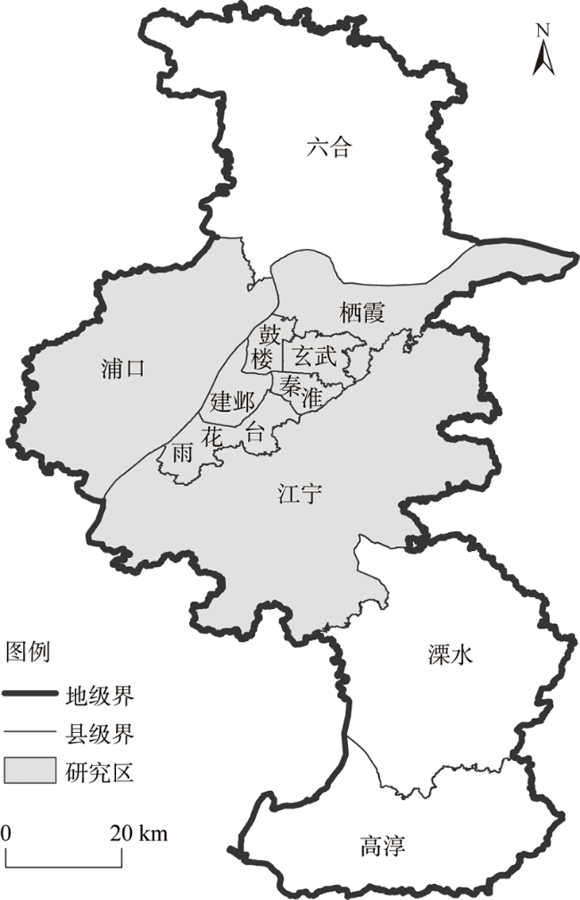
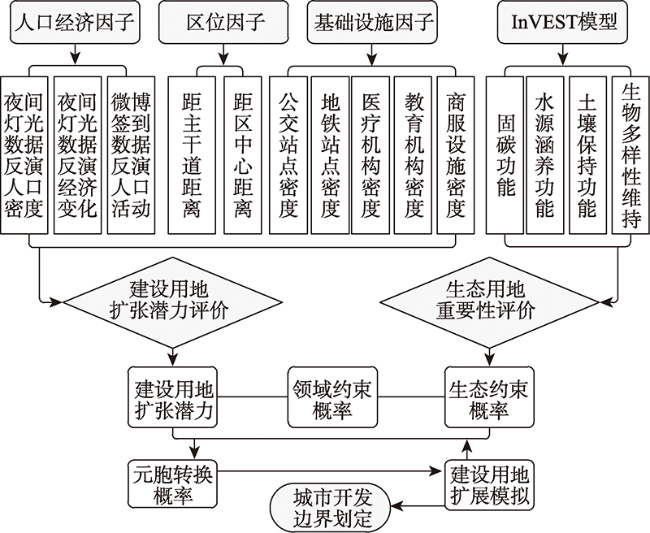
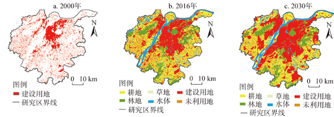
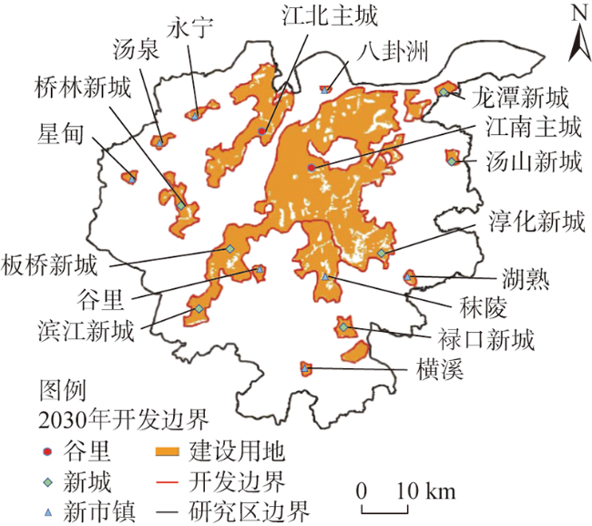
The delineation of urban development boundary is an important part of land spatial planning, and also a key to the implementation of land spatial governance, urban and rural development management, and ecological security management and control. It plays a fundamental and restrictive role in promoting the high-quality development of urban space. This article takes the central urban area of Nanjing as an example, and the logistic regression analysis model, InVEST model and CA model were used to explore and construct a method of urban development boundary delineation based on ecological constraints. According to the evaluation of the importance of urban ecological land and the spatial expansion potential of construction land, a simulation of urban land expansion in different target years was carried out to delineate urban development boundary. The results show that the expansion of urban construction land has dynamic, complex and systematic characteristics, and is subject to multi-factor interactions. The urban development boundary simulation based on ecological constraints can take into account the needs of urban space development and residents' high-quality ecological environment demands, promote the unification of urban development and ecological protection, the coordination of population economy and resources and the environment, and help enrich the delineation methods of urban development boundary research, which provide scientific reference for the preparation of land spatial planning.
SUN Wei , LIU Chong-gang , WANG Su-ning . Simulation research of urban development boundary based on ecological constraints: A case study of Nanjing[J]. JOURNAL OF NATURAL RESOURCES, 2021 , 36(11) : 2913 -2925 . DOI: 10.31497/zrzyxb.20211114
表1 城市建设用地扩展潜力评价因子Table 1 Evaluation factors of expansion potential of urban construction land |
| 类别 | 评价因子 | 单位 |
|---|---|---|
| 人口 | 常住人口密度 | 人/km2 |
| 人口活动分布 | 人/km2 | |
| 经济 | 经济变化 | 亿元 |
| 区位 | 距市中心的距离 | km |
| 距区中心的距离 | km | |
| 基础设施分布 | 距主干道距离 | km |
| 公交站点核密度 | 个/km2 | |
| 地铁站点核密度 | 个/km2 | |
| 医疗卫生点核密度 | 个/km2 | |
| 教育点核密度 | 个/km2 | |
| 商服点核密度 | 个/km2 |
表2 相关系数Table 2 Correlation coefficients |
| 解释变量 | 回归系数 | 标准误差 | Wald统计量 | 自由度 | 显著性水平 | 发生比率 |
|---|---|---|---|---|---|---|
| 常住人口密度 | 1.42 | 0.27 | 22.63 | 1 | <0.001 | 3.65 |
| 人口活动分布 | 17.96 | 4.1 | 41.29 | 1 | <0.001 | 1.95 |
| 经济变化 | 3.72 | 0.08 | 290.42 | 1 | <0.001 | 3.55 |
| 距区中心距离 | -0.18 | 0.09 | 3.62 | 1 | 0.05 | 0.9 |
| 距主干道距离 | -0.4 | 0.078 | 2.74 | 1 | <0.001 | 0.57 |
| 公交站点核密度 | 0.61 | 0.23 | 4.56 | 1 | 0.006 | 1.92 |
| 地铁站点核密度 | 0.6 | 0.2 | 12.52 | 1 | 0.001 | 1.54 |
| 教育点核密度 | -1.7 | 0.44 | 13.01 | 1 | <0.001 | 0.2 |
| 常量 | 1.24 | 1.03 | 56.5 | 1 | <0.001 | 2060.1 |
| [1] |
丛佃敏, 赵书河, 于涛, 等. 综合生态安全格局构建与城市扩张模拟的城市增长边界划定: 以天水市规划区(2015—2030年)为例. 自然资源学报, 2018, 33(1):14-26.
[
|
| [2] |
|
| [3] |
|
| [4] |
|
| [5] |
|
| [6] |
|
| [7] |
|
| [8] |
|
| [9] |
|
| [10] |
|
| [11] |
|
| [12] |
|
| [13] |
林坚, 乔治洋, 叶子君. 城市开发边界的“划”与“用”: 我国14个大城市开发边界划定试点进展分析与思考. 城市规划学刊, 2017, (2):36-43.
[
|
| [14] |
钟珊, 赵小敏, 郭熙, 等. 基于空间适宜性评价和人口承载力的贵溪市中心城区城市开发边界的划定. 自然资源学报, 2018, 33(5):83-94.
[
|
| [15] |
黄木易, 岳文泽, 何翔. 长江经济带城市扩张与经济增长脱钩关系及其空间异质性. 自然资源学报, 2018, 33(2):219-232.
[
|
| [16] |
苏伟忠, 杨桂山, 陈爽, 等. 城市增长边界分析方法研究: 以长江三角洲常州市为例. 自然资源学报, 2012, 27(2):322-331.
[
|
| [17] |
俞孔坚, 游鸿, 许立言, 等. 北京市住宅用地开发压力与城市扩张预景: 基于阻力面的分析. 地理研究, 2012, 31(7):1173-1184.
[
|
| [18] |
王振波, 张蔷, 张晓瑞, 等. 基于资源环境承载力的合肥市增长边界划定. 地理研究, 2013, 32(12):2302-2311.
[
|
| [19] |
黄木易, 岳文泽, 冯少茹, 等. 基于MCR模型的大别山核心区生态安全格局异质性及优化. 自然资源学报, 2019, 34(4):101-114.
[
|
| [20] |
周锐, 王新军, 苏海龙, 等. 平顶山新区生态用地的识别与安全格局构建. 生态学报, 2015, 35(6):2003-2012.
[
|
| [21] |
王颖, 顾朝林. 基于格网分析法的城市弹性增长边界划定研究: 以苏州市为例. 城市规划, 2017, 41(3):25-30.
[
|
| [22] |
张亮. 基于生态安全格局的城市增长边界划定与管理研究. 杭州: 浙江大学, 2018.
[
|
| [23] |
|
| [24] |
|
| [25] |
|
| [26] |
范擎宇, 杨山. 协调视角下长三角城市群的空间结构演变与优化. 自然资源学报, 2019, 34(8):1581-1592.
[
|
| [27] |
陈力, 关瑞明. 城市空间形态中的人类行为. 华侨大学学报: 自然科学版, 2000, 21(3):296-301.
[
|
| [28] |
李传华, 俞慧云, 张巧英, 等. 基于Logistic的土地利用格局模拟案例研究. 人民黄河, 2012, (10):103-105.
[
|
| [29] |
罗平, 姜仁荣, 李红旮, 等. 基于空间Logistic和Markov模型集成的区域土地利用演化方法研究. 中国土地科学, 2010, 24(1):31-36.
[
|
| [30] |
潘韬, 吴绍洪, 戴尔阜, 等. 基于InVEST模型的三江源区生态系统水源供给服务时空变化. 应用生态学报, 2013, 24(1):183-189.
[
|
| [31] |
杨园园, 戴尔阜, 付华. 基于InVEST模型的生态系统服务功能价值评估研究框架. 首都师范大学学报: 自然科学版, 2012, (3):44-50.
[
|
| [32] |
闫业超, 岳书平, 张树文. 降雨资料时间序列长度对降雨侵蚀力平均值置信度的影响. 自然资源学报, 2013, 28(2):321-327.
[
|
| [33] |
李季孝, 丁剑宏, 陶余铨, 等. 云南省土壤可蚀性及其空间分布特征. 人民黄河, 2019, (8):103-106.
[
|
| [34] |
何莎莎, 朱文博, 崔耀平, 等. 基于InVEST模型的太行山淇河流域土壤侵蚀特征研究. 长江流域资源与环境, 2019, 28(2):426-439.
[
|
| [35] |
党虹, 葛丽娟, 赵传燕, 等. 基于InVEST模型的称钩河流域土壤保持功能研究. 兰州大学学报: 自然科学版, 2018, 54(5):69-75.
[
|
| [36] |
马世发, 艾彬, 欧金沛. 约束性CA在城乡建设用地指标空间化中的应用. 地理科学, 2013, 36(10):91-97.
[
|
| [37] |
汪贝, 张金亭, 彭晓军. 基于约束性CA的“三规”空间管制整合引导下的城市增长模拟. 地理与地理信息科学, 2017, 33(5):69-74.
[
|
| [38] |
王海军, 夏畅, 张安琪, 等. 基于约束性CA的大都市郊区城镇增长的情景模拟与管控: 以武汉市江夏区为例. 地理科学进展, 2016, 35(7):793-805.
[
|
/
| 〈 |
|
〉 |

