
JOURNAL OF NATURAL RESOURCES >
Watershed-based policy integration approach to constructing territorial rainstorm flood safety pattern
Received date: 2020-07-03
Request revised date: 2021-01-09
Online published: 2021-11-28
Copyright
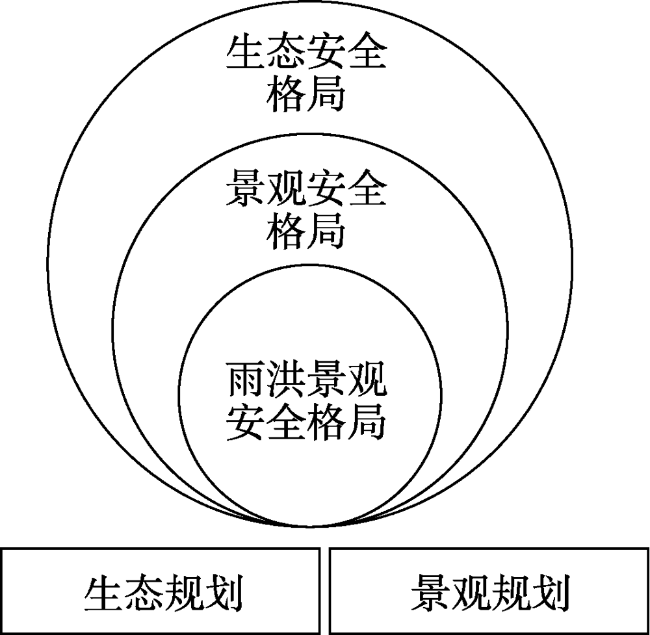
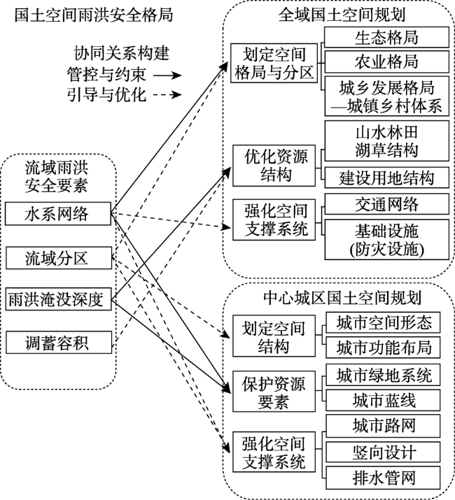
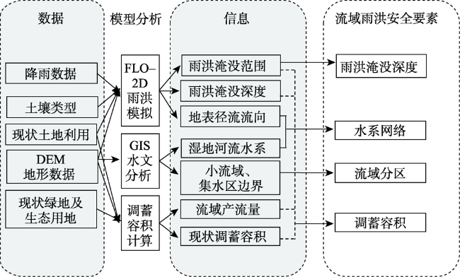
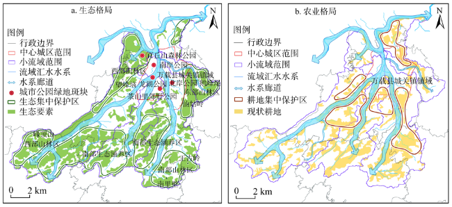
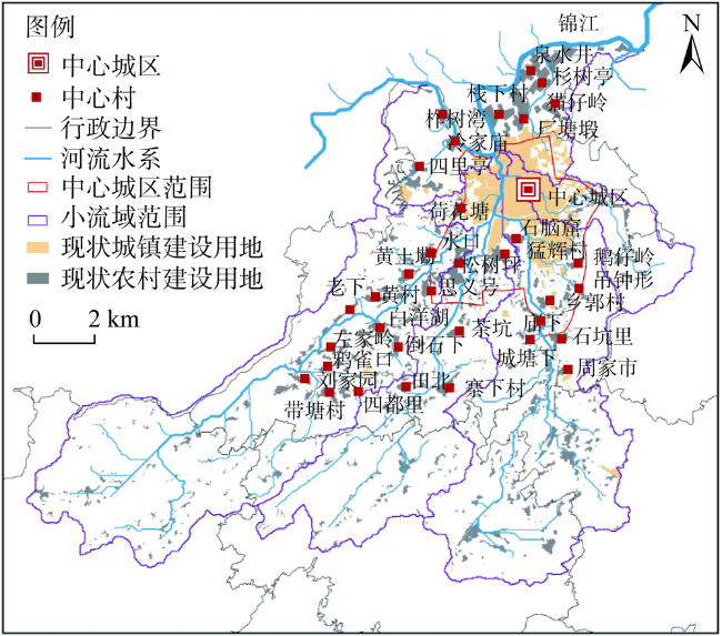
The increasing frequency of flood hazards in recent years highlighted the contradiction between urban construction and flood control. It is important to re-examine the core principles and methods of disaster prevention planning that focused on flood prevention infrastructure and sponge city planning for landscape ecological infrastructure. This paper proposes that, in the context of territorial spatial planning, the core principle of rainstorm flood safety pattern should be "policy integration". The integrated policies do not conflict in spatial layout, but lead to the same goal and result. Based on this core principle we proposed a theoretical framework of rainstorm flood control pattern in land space. Under this framework, the identification of stormwater control elements is the prerequisite, and the key approach is to establish an integrated relationship between stormwater safety elements and land use spatial structure, resource use, and infrastructure systems through controlling measures and guiding measures. This study aims at realizing the safety goals and forming spatial patterns on different spatial scales. To better interpret the theoretical framework, this paper takes the Zhenguan town, Wanzai county, Jiangxi province as a case study to explore and test the operationality and application value of the theoretical framework in practice. This research provides a new perspective and theoretical basis to achieve flood safety pattern.
XU Yi-qing , YU Ding-yi , RAN Jing . Watershed-based policy integration approach to constructing territorial rainstorm flood safety pattern[J]. JOURNAL OF NATURAL RESOURCES, 2021 , 36(9) : 2335 -2349 . DOI: 10.31497/zrzyxb.20210912
表1 数据来源Table 1 Data source |
| 数据类型 | 来源 | 数据/年份 | 空间分辨率 |
|---|---|---|---|
| 数字高程模型DEM | NASA SRTM1 v3.0 江西 | 2016 | 30 m×30 m |
| 现状土地利用 | 中国科学院环境科学数据库(根据Landsat遥感解译) | 2018 | 30 m×30 m |
| 卫星影像图 | 谷歌卫星影像图 | 2018 | 0.5 m |
| 现状道路 | 根据2015年现状地形图及2018年谷歌卫星影像矢量化 | 2018 | 0.5 m |
| 百年一遇降雨量 | 降雨总量:万载县暴雨强度计算公式结合芝加哥雨型计算器得出每个时段占降雨总量百分比,查阅江西省暴雨洪水查算手册得出 | 2017—2020 | — |
| 土壤类型 | HWSD中国土壤数据集 | 2017 | 30 m×30 m |
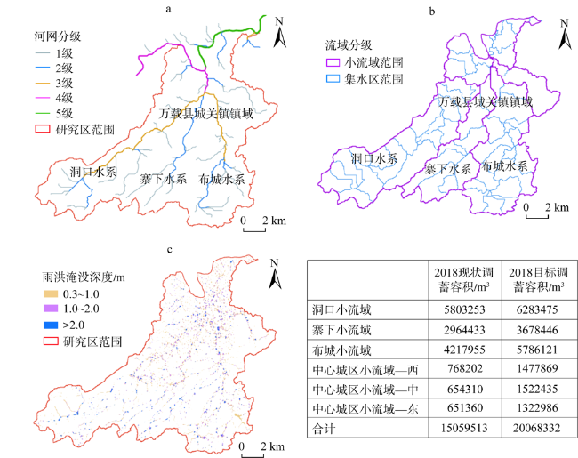
表2 雨洪调蓄容积调整表Table 2 The changes of rainstorm flood storage volume (万m3) |
| 容积小流域 | 2018年基期 | 2035年规划期 | |||
|---|---|---|---|---|---|
| 已实现调蓄容积 | 2018年产流量 | 2035年产流量 | 需增补调蓄容积 | ||
| 洞口小流域 | 580.33 | 628.35 | 635.28 | 6.93 | |
| 寨下小流域 | 296.44 | 367.54 | 383.29 | 15.74 | |
| 布城小流域 | 421.80 | 578.61 | 606.47 | 27.85 | |
| 中心城区小流域—西 | 76.82 | 147.79 | 151.73 | 3.95 | |
| 中心城区小流域—中 | 65.43 | 152.24 | 154.34 | 2.10 | |
| 中心城区小流域—东 | 65.14 | 132.30 | 139.20 | 6.90 | |
| 合计 | 1505.95 | 2006.83 | 2070.30 | 63.47 | |
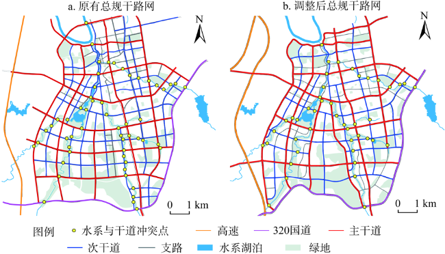
表3 规划道路长度表Table 3 The changes of rainstorm flood storage volume (km) |
| 道路类别 | 上版总规道路总长度 | 调整后总规道路总长度 |
|---|---|---|
| 主干道 | 57.358 | 61.426 |
| 次干道 | 67.561 | 48.568 |
| 支路 | 11.355 | 25.237 |
| 总计 | 136.274 | 135.231 |
| [1] |
史培军, 袁艺, 陈晋. 深圳市土地利用变化对流域径流的影响. 生态学报, 2001, 21(7):1041-1049, 1217.
[
|
| [2] |
|
| [3] |
|
| [4] |
赵晶. 城市化背景下的可持续雨洪管理. 国际城市规划, 2012, 27(2):114-119.
[
|
| [5] |
车伍, 吕放放, 李俊奇, 等. 发达国家典型雨洪管理体系及启示. 中国给水排水, 2009, 25(20):12-17.
[
|
| [6] |
潘海霞, 赵民. 国土空间规划体系构建历程、基本内涵及主要特点. 城乡规划, 2019, (5):4-10.
[
|
| [7] |
俞孔坚, 李迪华, 袁弘, 等. “海绵城市”理论与实践. 城市规划, 2015, 39(6):26-36.
[
|
| [8] |
焦胜, 韩静艳, 周敏, 等. 基于雨洪安全格局的城市低影响开发模式研究. 地理研究, 2018, 37(9):1704-1713.
[
|
| [9] |
曹艳群. 北京市东北部城乡结合部雨洪安全格局研究. 北京: 北京大学, 2008.
[
|
| [10] |
宋云, 俞孔坚. 构建城市雨洪管理系统的景观规划途径: 以威海市为例. 城市问题, 2007, (8):64-70.
[
|
| [11] |
张青萍, 李晓策, 陈逸帆, 等. 海绵城市背景下的城市雨洪景观安全格局研究. 现代城市研究, 2016, (7):6-11, 28.
[
|
| [12] |
车伍, 武彦杰, 杨正, 等. 海绵城市建设指南解读之城市雨洪调蓄系统的合理构建. 中国给水排水, 2015, 31(8):13-17, 23.
[
|
| [13] |
|
| [14] |
|
| [15] |
|
| [16] |
|
| [17] |
|
| [18] |
|
| [19] |
孙瑶, 曾振, 许乙青. 基于流域概念的城市生态排水体系构建: 以溆浦县城区生态排水体系构建为例. 中国园林, 2013, 29(10):91-95.
[
|
| [20] |
许乙青, 刘博, 黄娇. 南方丘陵地区城市规划地域性应对策略. 规划师, 2017, 33(11):85-93.
[
|
| [21] |
吴健生, 王仰麟, 张小飞, 等. 景观生态学在国土空间治理中的应用. 自然资源学报, 2020, 35(1):14-25.
[
|
| [22] |
莫琳, 俞孔坚. 构建城市绿色海绵: 生态雨洪调蓄系统规划研究. 城市发展研究, 2012, 19(5):130-134.
[
|
| [23] |
俞孔坚, 王思思, 李迪华, 等. 北京城市扩张的生态底线: 基本生态系统服务及其安全格局. 城市规划, 2010, 34(2):19-24.
[
|
| [24] |
杜腾飞, 齐伟, 朱西存, 等. 基于生态安全格局的山地丘陵区自然资源空间精准识别与管制方法. 自然资源学报, 2020, 35(5):1190-1200.
[
|
| [25] |
倪庆琳, 侯湖平, 丁忠义, 等. 基于生态安全格局识别的国土空间生态修复分区: 以徐州市贾汪区为例. 自然资源学报, 2020, 35(1):204-216.
[
|
| [26] |
杨冬冬, 曹易, 曹磊. 城市生态化雨洪管理系统构建技术方法和途径. 中国园林, 2019, 35(10): 24-28.
[
|
| [27] |
于海洋, 卢小平, 程钢, 等. 基于LiDAR数据的流域水系网络提取方法研究. 地理与地理信息科学, 2013, 29(1):17-21, 27.
[
|
| [28] |
王骏, 陈帅奇, 徐杰. 雨洪安全视角下城市设计导则的优化研究: 以嘉兴冶金片区为例. 城市规划学刊, 2019, (s1):227-233.
[
|
/
| 〈 |
|
〉 |