
JOURNAL OF NATURAL RESOURCES >
Determining priority areas for land ecological restoration based on ecological network-human disturbance: A case study of Changsha-Zhuzhou-Xiangtan Urban Agglomeration
Received date: 2020-10-08
Request revised date: 2021-03-29
Online published: 2021-11-28
Copyright
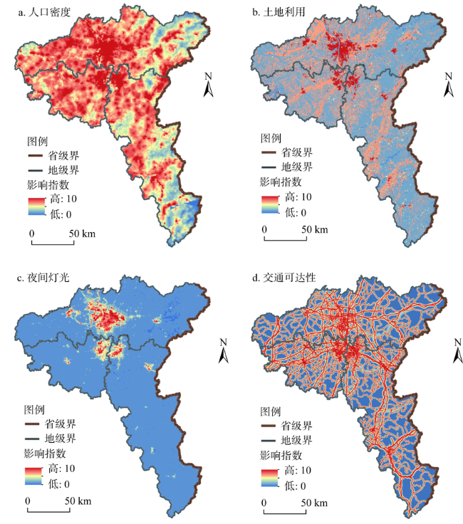
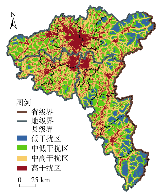
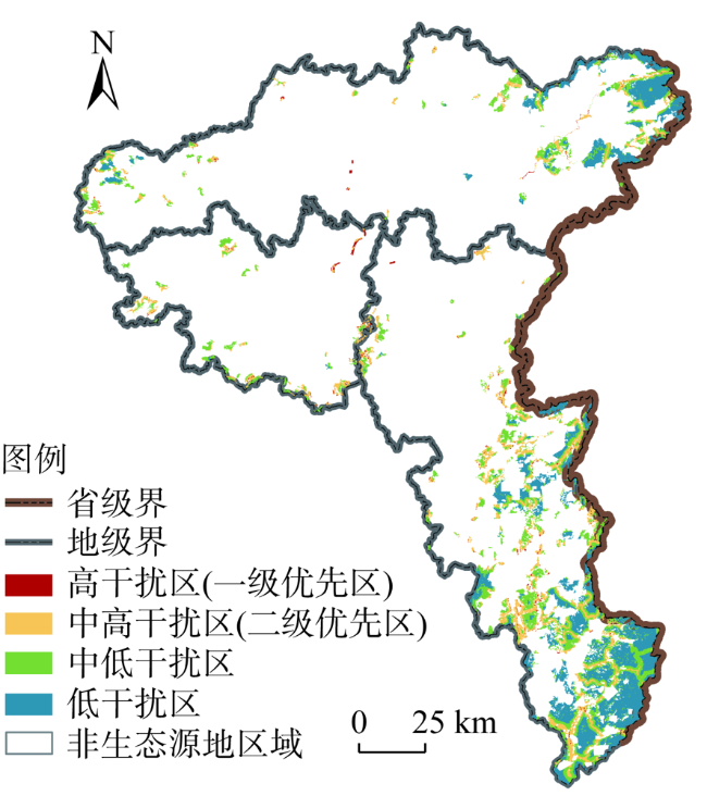
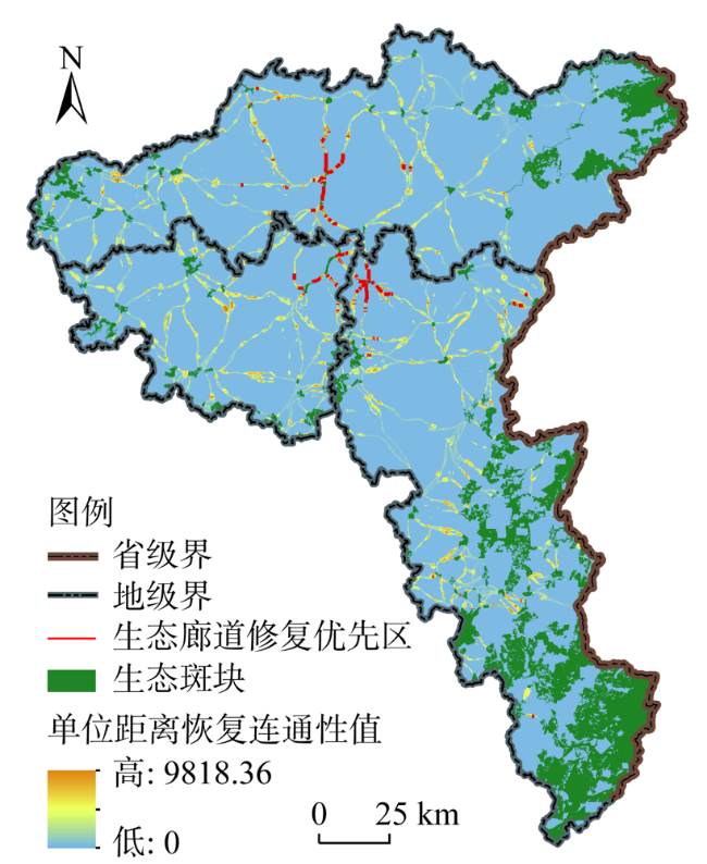
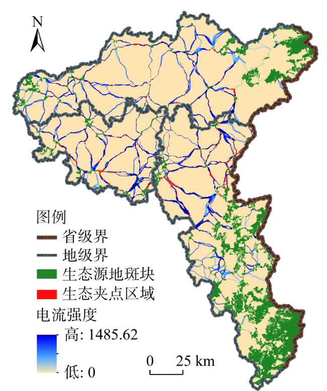
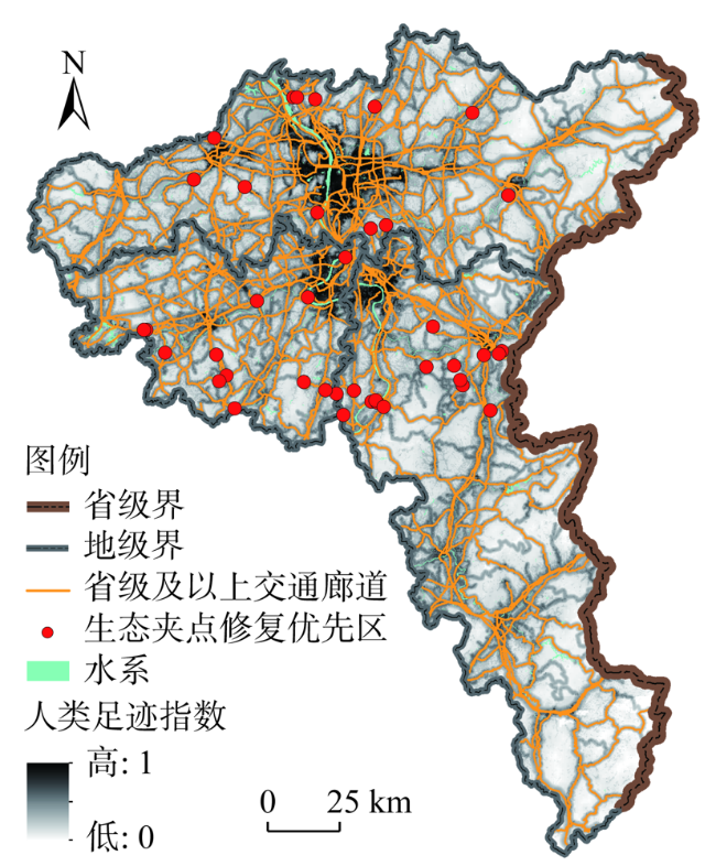
In the process of rapid industrialization and urbanization, the interference effect of human activities on the structure and function of ecosystem has been increasingly intensified. Land ecological restoration has become an essential topic of ecological civilization construction and land spatial planning. Determining priority areas for ecological restoration based on holistic protection and systematic governance, is a critical method for the scientific and orderly promotion of land ecological restoration. Taking Changsha-Zhuzhou-Xiangtan Urban Agglomeration as an example, we used human footprint to evaluate the intensity of human disturbance to the ecosystem quantitatively. On this basis, through the minimum cumulative resistance model, circuit theory, and cyclic window search method, the ecological network was identified, and the key areas where human disturbance caused damage to its structure and function were determined as priority areas for ecological restoration. The research showed that: (1) The human disturbance in the urban agglomeration presented a core-edge decreasing circle distribution, and the west was higher than the east while the north was higher than the south. In the study area, low disturbance area, medium-low disturbance area, medium-high disturbance area, and high disturbance area accounted for 12.66%, 32.31%, 37.70%, and 17.33% of the urban agglomeration land, respectively. (2) The ecological network was identified, which contained 140 ecological source patches and 307 potential ecological corridors between them. The corridors were 3986.02 km long, primarily distributed along with the Xiangjiang River system or located in the low hilly area with good vegetation coverage. (3) The priority areas for ecological restoration were determined, including a total of 867.17 km2 for source restoration, 97.83 km for corridor restoration, and 40 points for pinch point restoration. From the perspective of Point-Line-Polygon, restoration strategies were proposed to eliminate or weaken human disturbance, which would help to provide spatial guidance for formulating and implementing of land ecological restoration in the New Era.
JIAO Sheng , LIU Yi-cun , HAN Zong-wei , ZHOU Ke-jing , HU Liang , LIU Tie-xiong . Determining priority areas for land ecological restoration based on ecological network-human disturbance: A case study of Changsha-Zhuzhou-Xiangtan Urban Agglomeration[J]. JOURNAL OF NATURAL RESOURCES, 2021 , 36(9) : 2294 -2307 . DOI: 10.31497/zrzyxb.20210909
表1 各行政单元内生态修复优先区统计Table 1 Statistics of priority areas for ecological restoration within each administrative unit |
| 行政区 | 生态源地斑块修复优先区 | 生态廊道修复优先区 | 生态夹点修复优先区 | ||||
|---|---|---|---|---|---|---|---|
| 面积/km2 (占比/%) | 一级优先区面积 /km2 (占比/%) | 二级优先区面积 /km2(占比/%) | 长度/km (占比/%) | 数量/个 (占比/%) | |||
| 长沙市区 | 10.19 (1.18) | 3.56 (7.28) | 6.63 (0.81) | 37.34 (38.17) | 7 (17.5) | ||
| 长沙县 | 7.07 (0.82) | 0.31 (0.63) | 6.76 (0.83) | 3.22 (3.29) | 1 (2.5) | ||
| 宁乡市 | 42.33 (4.88) | 3.08 (6.3) | 39.25 (4.80) | 0.94 (0.96) | 2 (5.0) | ||
| 浏阳市 | 116.45 (13.43) | 3.58 (7.32) | 112.87 (13.79) | 0.5 (0.51) | 2 (5.0) | ||
| 株洲市区 | 13.06 (1.51) | 1.46 (2.99) | 11.6 (1.42) | 30.56 (31.24) | 0 (0) | ||
| 株洲县 | 16.38 (1.89) | 1.79 (3.66) | 14.59 (1.78) | 1.3 (1.33) | 7 (17.5) | ||
| 醴陵市 | 29.7 (3.42) | 1.83 (3.74) | 27.87 (3.41) | 4.05 (4.14) | 9 (22.5) | ||
| 攸县 | 155.22 (17.9) | 5.71 (11.68) | 149.51 (18.27) | 0.32 (0.33) | 0 (0) | ||
| 茶陵县 | 217.01 (25.03) | 10.14 (20.74) | 206.87 (25.28) | 1 (1.02) | 0 (0) | ||
| 炎陵县 | 166.19 (19.16) | 3.23 (6.61) | 162.96 (19.91) | 0.84 (0.86) | 0 (0) | ||
| 湘潭市区 | 12.96 (1.49) | 8.31 (17.0) | 4.65 (0.57) | 16.24 (16.6) | 2 (5.0) | ||
| 湘潭县 | 50.71 (5.85) | 4.54 (9.29) | 46.17 (5.64) | 1.52 (1.55) | 6 (15.0) | ||
| 湘乡市 | 21.3 (2.46) | 0.69 (1.41) | 20.61 (2.52) | 0 (0) | 4 (10.0) | ||
| 韶山市 | 8.6 (0.99) | 0.66 (1.35) | 7.94 (0.97) | 0 (0) | 0 (0) | ||
| 研究区 | 867.17 (100) | 48.89 (100) | 818.28 (100) | 97.83 (100) | 40 (100) | ||
| [1] |
|
| [2] |
|
| [3] |
李杨帆, 朱晓东, 孙翔, 等. 快速城市化对区域生态环境影响的时空过程及评价. 环境科学学报, 2007, 27(12):2060-2066.
[
|
| [4] |
李双成, 赵志强, 王仰麟. 中国城市化过程及其资源与生态环境效应机制. 地理科学进展, 2009, 28(1):63-70.
[
|
| [5] |
|
| [6] |
彭建, 吕丹娜, 董建权, 等. 过程耦合与空间集成: 国土空间生态修复的景观生态学认知. 自然资源学报, 2020, 35(1):3-13.
[
|
| [7] |
王军, 应凌霄, 钟莉娜. 新时代国土整治与生态修复转型思考. 自然资源学报, 2020, 35(1):26-36.
[
|
| [8] |
徐菲, 王永刚, 张楠, 等. 河流生态修复相关研究进展. 生态环境学报, 2014, 23(3):515-520.
[
|
| [9] |
马志阳, 查轩. 南方红壤区侵蚀退化马尾松林地生态恢复研究. 水土保持研究, 2008, (3):188-193, 196.
[
|
| [10] |
樊霆, 叶文玲, 陈海燕, 等. 农田土壤重金属污染状况及修复技术研究. 生态环境学报, 2013, 22(10):1727-1736.
[
|
| [11] |
黄海, 杨顺, 田尤, 等. 汶川地震重灾区泥石流灾损土地利用及生态修复模式: 以北川县都坝河小流域为例. 自然资源学报, 2020, 35(1):106-118.
[
|
| [12] |
关军洪, 郝培尧, 董丽, 等. 矿山废弃地生态修复研究进展. 生态科学, 2017, 36(2):193-200.
[
|
| [13] |
段锦, 康慕谊, 江源. 东江流域生态系统服务价值变化研究. 自然资源学报, 2012, 27(1):90-103.
[
|
| [14] |
|
| [15] |
倪庆琳, 侯湖平, 丁忠义, 等. 基于生态安全格局识别的国土空间生态修复分区: 以徐州市贾汪区为例. 自然资源学报, 2020, 35(1):204-216.
[
|
| [16] |
方莹, 王静, 黄隆杨, 等. 基于生态安全格局的国土空间生态保护修复关键区域诊断与识别: 以烟台市为例. 自然资源学报, 2020, 35(1):190-203.
[
|
| [17] |
韩宗伟, 焦胜, 胡亮, 等. 廊道与源地协调的国土空间生态安全格局构建. 自然资源学报, 2019, 34(10):2244-2256.
[
|
| [18] |
苏冲, 董建权, 马志刚, 等. 基于生态安全格局的山水林田湖草生态保护修复优先区识别: 以四川省华蓥山区为例. 生态学报, 2019, 39(23):8948-8956.
[
|
| [19] |
朱捷, 苏杰, 尹海伟, 等. 基于源地综合识别与多尺度嵌套的徐州生态网络构建. 自然资源学报, 2020, 35(8):1986-2001.
[
|
| [20] |
贺艳华, 唐承丽, 周国华, 等. 基于地理学视角的快速城市化地区空间冲突测度: 以长株潭城市群地区为例. 自然资源学报, 2014, 29(10):1660-1674.
[
|
| [21] |
欧阳晓, 朱翔, 贺清云. 基于生态系统服务和生态系统健康的生态风险评价: 以长株潭城市群为例. 生态学报, 2020, 40(16):5478-5489.
[
|
| [22] |
刘世梁, 刘芦萌, 武雪, 等. 区域生态效应研究中人类活动强度定量化评价. 生态学报, 2018, 38(19):6797-6809.
[
|
| [23] |
|
| [24] |
|
| [25] |
|
| [26] |
|
| [27] |
|
| [28] |
徐勇, 孙晓一, 汤青. 陆地表层人类活动强度: 概念、方法及应用. 地理学报, 2015, 70(7):1068-1079.
[
|
| [29] |
|
| [30] |
|
| [31] |
王玉莹, 金晓斌, 沈春竹, 等. 东部发达区生态安全格局构建: 以苏南地区为例. 生态学报, 2019, 39(7):2298-2310.
[
|
| [32] |
彭建, 李慧蕾, 刘焱序, 等. 雄安新区生态安全格局识别与优化策略. 地理学报, 2018, 73(4):701-710.
[
|
| [33] |
|
| [34] |
|
| [35] |
陈昕, 彭建, 刘焱序, 等. 基于“重要性—敏感性—连通性”框架的云浮市生态安全格局构建. 地理研究, 2017, 36(3):471-484.
[
|
| [36] |
黄木易, 岳文泽, 冯少茹, 等. 基于MCR模型的大别山核心区生态安全格局异质性及优化. 自然资源学报, 2019, 34(4):771-784.
[
|
| [37] |
朱强, 俞孔坚, 李迪华. 景观规划中的生态廊道宽度. 生态学报, 2005, 25(9):2406-2412.
[
|
| [38] |
王回茴, 李汉廷, 谢苗苗, 等. 资源型城市工矿用地系统修复的生态安全格局构建. 自然资源学报, 2020, 35(1):162-173.
[
|
| [39] |
|
| [40] |
黄隆杨, 刘胜华, 方莹, 等. 基于“质量—风险—需求”框架的武汉市生态安全格局构建. 应用生态学报, 2019, 30(2):615-626.
[
|
| [41] |
宋利利, 秦明周. 整合电路理论的生态廊道及其重要性识别. 应用生态学报, 2016, 27(10):3344-3352.
[
|
| [42] |
|
/
| 〈 |
|
〉 |

