
JOURNAL OF NATURAL RESOURCES >
The schematic design and supervision system of the county main functional areas governance
Received date: 2020-02-08
Revised date: 2020-04-02
Online published: 2021-10-28
Copyright
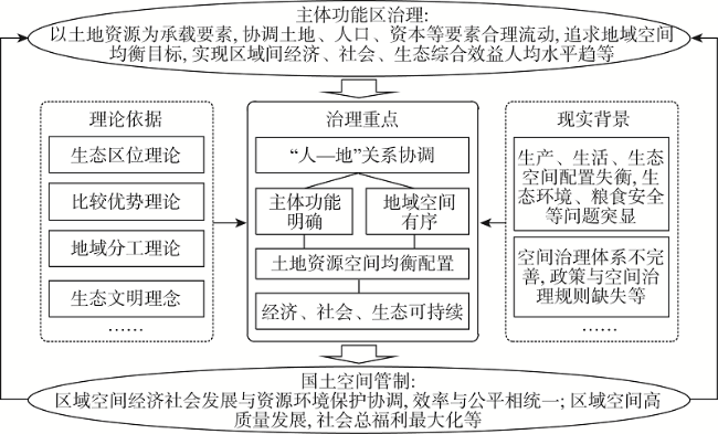
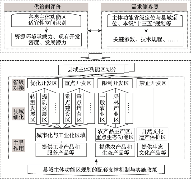
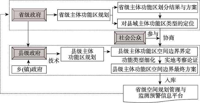
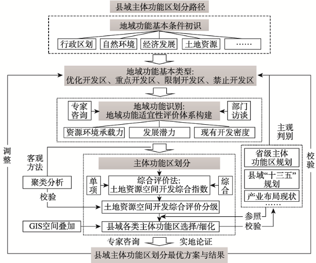
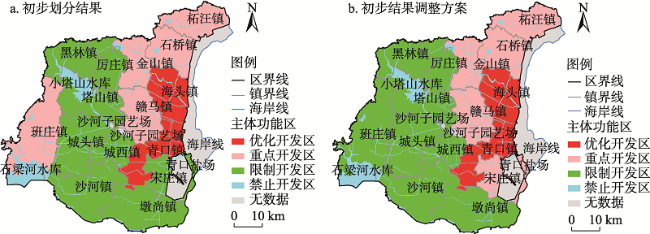
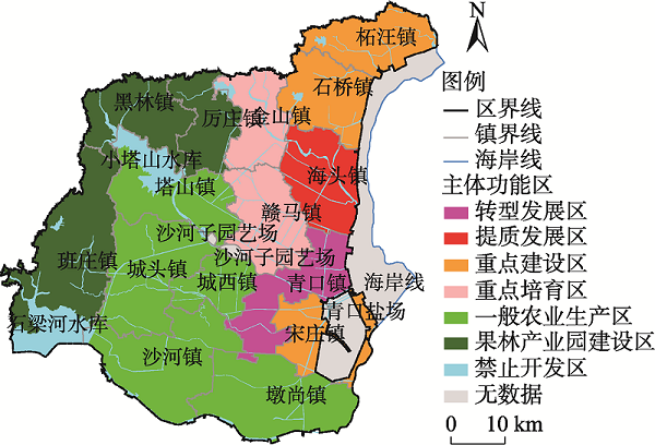
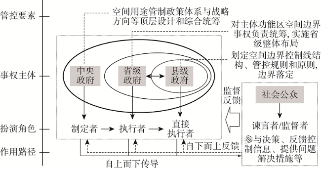
How to widen the application of the principle and method of main functional areas governance and effectively improve the effect of territory space governance at the county level is a realistic issue in China's natural resources management in the new era. Main functional areas play a fundamental role in territorial space control, focusing on the spatial scope related to high development density, low resource and environment bearing capacity, and issues concerning national food and ecological security. The county main functional divisions should follow the idea of suitability discrimination of supply and demand orientation, take into account the ambiguity of spatial boundary and the overlapping of supervision responsibilities and powers, and integrate the technology discrimination with the main body consultation, so as to be implemented on the administrative boundary of town and village as far as possible. The application study on Ganyu county in Lianyungang city shows that the administrative boundary of the town can be used as the spatial boundary threshold to divide the main functional areas such as transition development areas, upgrading development areas, key development areas, key cultivation areas, general agricultural production areas, fruit industrial park construction area, and forbidden development areas. The delineation and implementation of county main functional areas should take into full consideration the relationship between spatial affairs and powers at the county level, and build a governance and supervision system with provincial-level and county-level governments as the main body and the participation of the whole society. And it is necessary to form a coordinated and interactive policy mechanism of control and decision-making from the three aspects of land market, policy regulation and social supervision.
CHEN Lei , JIANG Hai . The schematic design and supervision system of the county main functional areas governance[J]. JOURNAL OF NATURAL RESOURCES, 2021 , 36(8) : 1988 -2005 . DOI: 10.31497/zrzyxb.20210807
表1 赣榆区主体功能区适宜性评价指标体系Table 1 The suitability evaluation index system of main functional areas in Ganyu |
| 目标层 | 支持层 | 因素层 | 指标层 | 单位 | 指标说明 | |
|---|---|---|---|---|---|---|
| 指标表征内涵 | 指标计算公式 | |||||
| 主 体 功 能 区 适 宜 性 | 资源 环境 承载 能力 | 资源承载能力 | 人均耕地面积+ | hm2/人 | 土地资源承载能力 | 耕地面积与总人口的比值 |
| 人均水资源占有量+ | m3/人 | 水资源承载能力 | 水资源总量与总人口的比值 | |||
| 环境承载能力 | 水污染负荷- | mg/L | 水资源生态敏感性 | 以“化学需氧量COD”衡量 | ||
| 单位面积农药负荷- | kg/hm2 | 土地生态敏感性 | 农药施用量与耕地面积比值 | |||
| 单位面积化肥负荷- | kg/hm2 | 土地生态敏感性 | 化肥施用量与耕地面积比值 | |||
| 林木覆盖率+ | % | 水土保持重要性 | 林地面积与土地总面积比值 | |||
| 湿地面积占比+ | % | 水源涵养重要性 | 湿地面积与土地总面积比值 | |||
| 现有 开发 密度 (程度) | 社会经济发展程度 | 非农产业占比+ | % | 工业化水平 | 第二产业产值占国民生产总值比例 | |
| 城镇化率+ | % | 城镇化水平 | 城镇人口与总人口比值 | |||
| 人口密度+ | 人/km2 | 人口集聚程度 | 总人口与辖区面积的比值 | |||
| 地均GDP+ | 万元/km2 | 经济集中程度与效率 | GDP与辖区面积的比值 | |||
| 资源利用强度 | 复种指数+ | % | 耕地利用强度 | 农作物总播种面积与耕地面积比值 | ||
| 土地开发强度+ | % | 土地集约化利用强度 | 建设用地面积与辖区面积比值 | |||
| 水资源开发利用率+ | % | 水资源利用强度 | 区域用水量与水资源总量比值 | |||
| 发展 潜力 | 经济活力 | GDP增长率+ | % | 经济发展速度 | 当年与上一年GDP的差值与当年GDP的比值 | |
| 固定资产投资增长率+ | % | 经济建设投入力度 | 当年与上一年固定资产投资额的差值与当年的比值 | |||
| 人口迁移率+ | % | 经济发展吸引力 | 流入人口与流出人口之和与总人口的比值 | |||
| 居民可支配收入+ | 元 | 地区消费能力 | 以“农民人均所得”表征 | |||
| 区位条件 | 国有公路面积率+ | % | 交通优势条件 | 国有公路面积与区域面积比值 | ||
| 区位优势度+ | m | 区位集聚辐射度 | 以“到市中心的距离”衡量 | |||
| 科教水平状况 | 基础教育状况+ | 人 | 教育水平重视程度 | 以“劳动年龄内上学的学生数”衡量 | ||
| 科技投入强度+ | % | 科技水平重视程度 | 科技从业人员数与乡村从业人员数的比值 | |||
注:指标层中,“符号–/+”表示指标属性,其中:“–”表示负向指标,“+”表示正向指标。 |
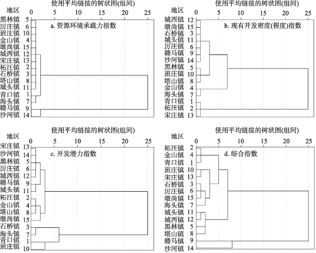
表2 赣榆区主体功能区划分分指数和综合指数Table 2 The sub-index and composite index of main functional divisions in Ganyu |
| 指数类别 | 指数要素 | 青口镇 | 柘汪镇 | 石桥镇 | 金山镇 | 黑林镇 | 厉庄镇 | 海头镇 | 塔山镇 | 赣马镇 | 班庄镇 | 城头镇 | 城西镇 | 宋庄镇 | 沙河镇 | 墩尚镇 | |
|---|---|---|---|---|---|---|---|---|---|---|---|---|---|---|---|---|---|
| 因素 层分 指数 | 资源环境承载力 | 资源承载力 | 0.0142 | 0.0543 | 0.0531 | 0.0603 | 0.0921 | 0.0830 | 0.0378 | 0.0738 | 0.0460 | 0.0753 | 0.0630 | 0.0505 | 0.0563 | 0.0515 | 0.0678 |
| 环境承载力 | 0.0940 | 0.1284 | 0.1280 | 0.1573 | 0.1370 | 0.1413 | 0.0941 | 0.1213 | 0.3796 | 0.1417 | 0.1158 | 0.1104 | 0.1006 | 0.3278 | 0.1362 | ||
| 现有开发密度 | 社会经济发展程度 | 0.1191 | 0.1310 | 0.0623 | 0.1052 | 0.0480 | 0.0729 | 0.0808 | 0.0369 | 0.0568 | 0.0350 | 0.0597 | 0.0656 | 0.1289 | 0.0427 | 0.0561 | |
| 资源利用强度 | 0.1169 | 0.0972 | 0.0846 | 0.0836 | 0.0681 | 0.0749 | 0.1012 | 0.0909 | 0.0972 | 0.0861 | 0.0881 | 0.0888 | 0.1201 | 0.1030 | 0.1017 | ||
| 发展 潜力 | 经济活力 | 0.1474 | 0.1190 | 0.1292 | 0.1255 | 0.1006 | 0.1174 | 0.1356 | 0.1338 | 0.1092 | 0.1442 | 0.1076 | 0.1265 | 0.1158 | 0.0922 | 0.1235 | |
| 区位条件 | 0.0520 | 0.0523 | 0.0506 | 0.0350 | 0.0608 | 0.0416 | 0.0423 | 0.0322 | 0.0356 | 0.0535 | 0.0433 | 0.0305 | 0.0487 | 0.0492 | 0.0465 | ||
| 科教水平状况 | 0.0645 | 0.0179 | 0.0464 | 0.0172 | 0.0274 | 0.0141 | 0.0481 | 0.0111 | 0.0221 | 0.0434 | 0.0098 | 0.0100 | 0.0059 | 0.0538 | 0.0330 | ||
| 支持 层分 指数 | 资源环境承载力 | 0.0223 | 0.0340 | 0.0338 | 0.0414 | 0.0397 | 0.0398 | 0.0247 | 0.0343 | 0.0921 | 0.0391 | 0.0321 | 0.0296 | 0.0278 | 0.0801 | 0.0371 | |
| 现有开发密度 | 0.0378 | 0.0374 | 0.0228 | 0.0306 | 0.0179 | 0.0234 | 0.0286 | 0.0191 | 0.0235 | 0.0180 | 0.0229 | 0.0241 | 0.0402 | 0.0217 | 0.0241 | ||
| 发展潜力 | 0.0376 | 0.0279 | 0.0324 | 0.0275 | 0.0263 | 0.0264 | 0.0330 | 0.0284 | 0.0249 | 0.0352 | 0.0244 | 0.0268 | 0.0260 | 0.0260 | 0.0297 | ||
| 综合指数 | 0.0329 | 0.0329 | 0.0298 | 0.0329 | 0.0279 | 0.0297 | 0.0289 | 0.0273 | 0.0461 | 0.0310 | 0.0264 | 0.0268 | 0.0311 | 0.0420 | 0.0303 | ||
注:数据均来自于2018年《赣榆统计年鉴》,赣榆区自然资源与规划局、农业农村局、生态环境局、水利局、发展与改革委员会和统计局的相关部门统计数据和调研数据。 |
表3 赣榆区主体功能区划分指标分指数和综合指数聚类结果Table 3 The sub-index and composite index clustering results of main functional divisions in Ganyu |
| 指数项目 | 青口镇 | 柘汪镇 | 石桥镇 | 金山镇 | 黑林镇 | 厉庄镇 | 海头镇 | 塔山镇 | 赣马镇 | 班庄镇 | 城头镇 | 城西镇 | 宋庄镇 | 沙河镇 | 墩尚镇 | |
|---|---|---|---|---|---|---|---|---|---|---|---|---|---|---|---|---|
| 资源环境承载力 | 指数 | 0.0223 | 0.034 | 0.0338 | 0.0414 | 0.0397 | 0.0398 | 0.0247 | 0.0343 | 0.0921 | 0.0391 | 0.0321 | 0.0296 | 0.0278 | 0.0801 | 0.0371 |
| 类别 | 1 | 2 | 2 | 2 | 2 | 2 | 1 | 2 | 4 | 2 | 2 | 2 | 2 | 3 | 2 | |
| 现有开发密度 | 指数 | 0.0378 | 0.0374 | 0.0228 | 0.0306 | 0.0179 | 0.0234 | 0.0286 | 0.0191 | 0.0235 | 0.018 | 0.0229 | 0.0241 | 0.0402 | 0.0217 | 0.0241 |
| 类别 | 4 | 4 | 2 | 3 | 1 | 2 | 3 | 1 | 2 | 1 | 2 | 2 | 4 | 2 | 2 | |
| 发展潜力 | 指数 | 0.0376 | 0.0279 | 0.0324 | 0.0275 | 0.0263 | 0.0264 | 0.033 | 0.0284 | 0.0249 | 0.0352 | 0.0244 | 0.0268 | 0.026 | 0.026 | 0.0297 |
| 类别 | 4 | 2 | 3 | 2 | 1 | 1 | 3 | 2 | 1 | 4 | 1 | 1 | 1 | 1 | 2 | |
| 综合状况 | 指数 | 0.0329 | 0.0329 | 0.0298 | 0.0329 | 0.0279 | 0.0297 | 0.0289 | 0.0273 | 0.0461 | 0.031 | 0.0264 | 0.0268 | 0.0311 | 0.042 | 0.0303 |
| 类别 | 2 | 2 | 2 | 2 | 1 | 2 | 2 | 1 | 4 | 2 | 1 | 1 | 2 | 3 | 2 | |
注:“类别”是聚类结果,用数字1~4表示并衡量指标程度,分别表示低、中、较高、高。 |
| [1] |
黄征学, 潘彪. 主体功能区规划实施进展、问题及建议. 中国国土资源经济: 1-8, 2020-03-05. https://doi-org-s.vpn2.njau.edu.cn/10.19676/j.cnki.1672-6995.000425
[
|
| [2] |
林丽群, 李娜, 李国煜, 等. 基于主体功能区的福建省城镇建设用地利用效率研究. 自然资源学报, 2018, 33(6): 1018-1028.
[
|
| [3] |
樊杰. 我国主体功能区划的科学基础. 地理学报, 2007, 62(4): 339-350.
[
|
| [4] |
樊杰. 中国主体功能区划方案. 地理学报, 2015, 70(2): 186-201.
[
|
| [5] |
盛科荣, 樊杰. 主体功能区作为国土开发的基础制度作用. 中国科学院院刊, 2016, 31(1): 44-50.
[
|
| [6] |
俞勇军, 陆玉牒. 江西省区域经济发展空间差异研究. 人文地理, 2004, 19(3): 41-45.
[
|
| [7] |
王敏, 熊丽君, 黄沈发. 上海市主体功能区划分技术方法研究. 环境科学研究, 2008, 21(4): 205-209.
[
|
| [8] |
王华, 刘耀林, 姬盈利. 基于多目标微粒群优化算法的土地利用分区模型. 农业工程学报, 2012, 28(12): 237-244.
[
|
| [9] |
罗伟玲, 王艳阳, 张恒. 基于多源数据的主体功能区划分方法: 以广州市为例. 热带地理, 2020, 40(1): 110-118.
[
|
| [10] |
顾朝林, 张晓明, 刘晋媛, 等. 盐城开发空间区划及其思考. 地理学报, 2007, 62(8): 787-798.
[
|
| [11] |
王瑞君, 高士平, 宇文会娟, 等. 平泉县生态功能区划与主体功能区划研究. 地理与地理信息科学, 2007, 23(5): 95-99.
[
|
| [12] |
王强, 伍世代, 李永实, 等. 福建省域主体功能区划分实践. 地理学报, 2009, 64(6): 725-735.
[
|
| [13] |
林锦耀, 黎夏. 基于空间自相关的东莞市主体功能区划分. 地理研究, 2014, 33(2): 349-357.
[
|
| [14] |
陈磊, 姜海. 主体功能区导向下的土地资源空间配置: 对土地生长空间演进规律的理性思考. 中国土地科学, 2019, 33(10): 22-30.
[
|
| [15] |
陈磊, 姜海. 从土地资源优势区配置到主体功能区管理: 一个国土空间治理的逻辑框架. 中国土地科学, 2019, 33(6): 10-17.
[
|
| [16] |
孙乾翔, 朱文龙, 胡静静, 等. 基于系统聚类分析的徐州市主体功能分区研究. 国土与自然资源研究, 2018, (4): 33-37.
[
|
| [17] |
吴晓婵. 我国县域城乡一体化发展问题研究. 湘潭: 湘潭大学, 2014.
[
|
| [18] |
张晓瑞, 宗跃光. 区域主体功能区规划模型、方法和应用研究: 以京津地区为例. 地理科学, 2010, 30(5): 728-734.
[
|
| [19] |
唐常春. 流域主体功能区划方法与指标体系构建: 以长江流域为例. 地理研究, 2011, 30(12): 2173-2185.
[
|
| [20] |
庞国彧, 华晨, 李利, 等. 多规融合导向下地级市主体功能区划分研究: 以丽水市为例. 西部人居环境学刊, 2016, 31(2): 71-76.
[
|
| [21] |
赵广英, 李晨. 国土空间规划体系下的详细规划技术改革思路. 城市规划学刊, 2019, (4): 37-46.
[
|
| [22] |
桑劲, 柳朴. 城市开发边界的治理制度探索: 基于省—县两级事权主体的设计. 规划师, 2019, 35(2): 26-31.
[
|
| [23] |
薄文广, 安虎森, 李杰. 主体功能区建设与区域协调发展: 促进亦或冒进. 中国人口·资源与环境, 2011, 21(10): 121-128.
[
|
| [24] |
代明, 刘燕妮, 陈罗俊. 基于主体功能区划和机会成本的生态补偿标准分析. 自然资源学报, 2013, 28(8): 1310-1317.
[
|
/
| 〈 |
|
〉 |
