
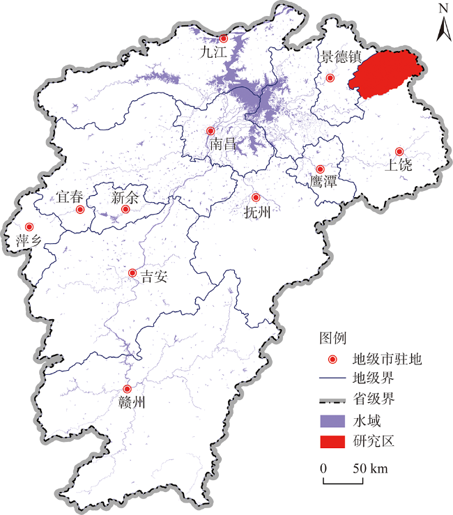
JOURNAL OF NATURAL RESOURCES >
Evolution characteristics and possible impact factors for the changing pattern and function of "Production-Living-Ecological" space in Wuyuan county
Received date: 2020-11-16
Revised date: 2021-02-02
Online published: 2021-07-28
Copyright
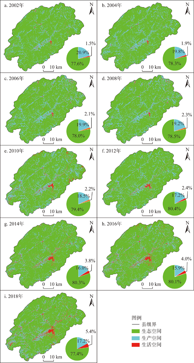
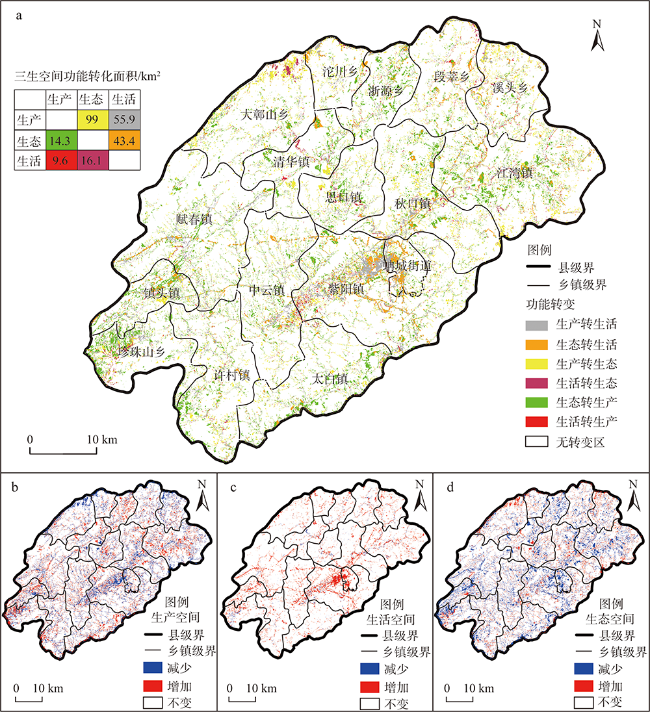
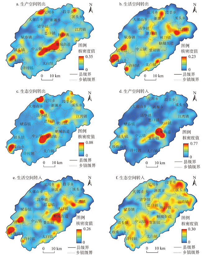
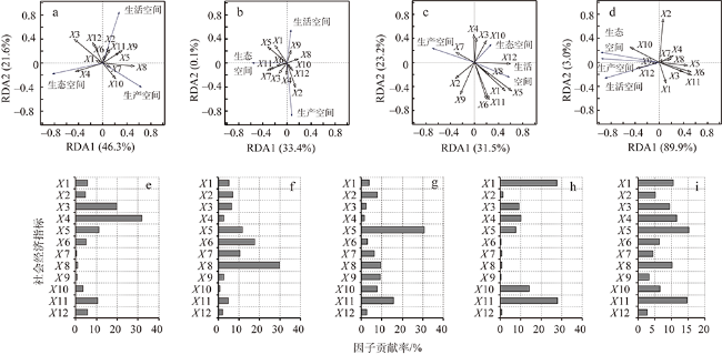
Based on "Production-Living-Ecological" space theory, the productive, living and ecological spaces in Wuyuan county were classified based on the 30 m spatial resolution Landsat time-series images. The spatial and temporal characteristics of the three types of spaces were further analyzed. The kernel density estimation method was applied to explore the spatial features for the conversions among three types of spaces. In addition, to further identify the causes of these changes, Redundancy Analysis (RDA) method was applied to attribute the spatiotemporal changes to different socioeconomic factors. Results showed that the two indices, namely, mean area of patches and aggregation index, decreased in both living space and ecological space, while they increased in production space during 2002-2018. We revealed that the fragmentation and dispersion of production space and ecological space was enhanced due to increasing urban area and living spaces, which facilitated the splitting of the continuity of production space and ecological space. From the perspective of changing function, 56% and 44% of the increased living space area was from production space (mainly cropland) and ecological space (mainly forest or grassland), respectively. The living space area showed a significant (P<0.05) increasing trend, the ecological space area showed a non-significant increasing trend; while the production space area showed a significant decreasing trend. All this revealed that the urbanization rate was accelerated by the rapid growth of tourism economy, and the ecological environment improved in Wuyuan county during 2002-2018.
JIAO Geng-ying , YANG Xiao-zhong , HUANG Zhi-qiang , ZHANG Xiao , LU Lin . Evolution characteristics and possible impact factors for the changing pattern and function of "Production-Living-Ecological" space in Wuyuan county[J]. JOURNAL OF NATURAL RESOURCES, 2021 , 36(5) : 1252 -1267 . DOI: 10.31497/zrzyxb.20210513
表1 本文利用的Landsat TM/ETM影像来源卫星及日期Table 1 The platforms, paths/rows and dates of selected Landsat images covering Wuyuan county |
| 来源卫星 | 条带(行)号 | 影像日期 |
|---|---|---|
| Landsat-8 | 120(40) | 2014/6/11,2016/4/29,2018/4/19 |
| Landsat-7 | 2012/10/19 | |
| Landsat-5 | 2002/9/30,2004/10/21,2006/9/25,2008/10/16,2010/8/3 |
表2 婺源县国土空间用地分类体系Table 2 The spatial planning system of national territory in Wuyuan county |
| 一级分类 | 二级分类 | 具体用地分类 |
|---|---|---|
| 生产空间 | 农业生产空间 | 水田、旱地、园地 |
| 生活空间 | 城镇生活空间 | 城镇建设用地、城市交通用地 |
| 乡村生活空间 | 乡村居民点用地、乡村公路用地 | |
| 生态空间 | 绿色空间 | 森林、草地 |
| 蓝色空间 | 湖泊、库塘、河流、滩地 |
表3 婺源县“三生空间”景观格局指数变化Table 3 The variations of calculated landscape indices based on the area and spatial patterns of "Production-Living-Ecological" space in Wuyuan county from 2002 to 2018 |
| 年份 | 平均斑块面积MPS/km2 | 最大斑块面积LPI/km2 | 分维数PAFRAC | 聚集度AI | 香农多样性指数SHDI |
|---|---|---|---|---|---|
| 2002 | 19.330 | 79.687 | 1.361 | 93.769 | 0.575 |
| 2004 | 19.567 | 56.758 | 1.358 | 93.592 | 0.614 |
| 2006 | 19.332 | 72.951 | 1.352 | 93.181 | 0.640 |
| 2008 | 20.208 | 81.554 | 1.360 | 94.609 | 0.547 |
| 2010 | 17.126 | 24.689 | 1.357 | 92.345 | 0.629 |
| 2012 | 18.593 | 54.637 | 1.365 | 93.459 | 0.650 |
| 2014 | 15.484 | 75.523 | 1.353 | 93.301 | 0.636 |
| 2016 | 14.649 | 40.461 | 1.338 | 92.848 | 0.698 |
| 2018 | 16.770 | 42.417 | 1.377 | 92.535 | 0.7031 |
表4 婺源县“三生空间”各类空间的景观格局指数变化Table 4 The variations of various landscape pattern indices based on "Production-Living-Ecological" space in Wuyuan county from 2002 to 2018 |
| 年份 | 平均斑块面积MPS/km2 | 最大斑块面积LPI/km2 | 分维数PAFRAC | 聚集度AI | ||||||||
|---|---|---|---|---|---|---|---|---|---|---|---|---|
| 生产 | 生活 | 生态 | 生产 | 生活 | 生态 | 生产 | 生活 | 生态 | 生产 | 生活 | 生态 | |
| 2002 | 6.208 | 1.046 | 177.571 | 1.974 | 0.125 | 79.686 | 1.400 | 1.366 | 1.295 | 83.054 | 68.103 | 96.661 |
| 2004 | 7.598 | 1.225 | 170.943 | 2.398 | 0.050 | 56.757 | 1.409 | 1.311 | 1.316 | 84.484 | 64.765 | 96.545 |
| 2006 | 7.017 | 1.509 | 173.639 | 2.139 | 0.060 | 72.950 | 1.390 | 1.359 | 1.292 | 84.153 | 73.896 | 96.190 |
| 2008 | 5.823 | 1.701 | 179.869 | 1.705 | 0.233 | 81.554 | 1.399 | 1.329 | 1.296 | 82.119 | 69.518 | 96.403 |
| 2010 | 7.445 | 1.950 | 175.674 | 1.695 | 0.471 | 24.689 | 1.393 | 1.316 | 1.323 | 84.453 | 76.060 | 96.710 |
| 2012 | 7.148 | 2.050 | 172.659 | 0.960 | 0.224 | 54.637 | 1.409 | 1.315 | 1.303 | 83.373 | 76.307 | 96.639 |
| 2014 | 4.346 | 2.662 | 162.593 | 0.477 | 0.833 | 75.523 | 1.391 | 1.303 | 1.289 | 80.472 | 78.280 | 96.657 |
| 2016 | 4.446 | 2.393 | 132.591 | 0.656 | 0.890 | 40.461 | 1.369 | 1.293 | 1.287 | 81.379 | 78.320 | 96.399 |
| 2018 | 5.393 | 2.802 | 128.527 | 0.984 | 0.976 | 42.4168 | 1.058 | 1.052 | 1.051 | 80.879 | 78.356 | 96.279 |
表5 婺源县2002—2018年“三生空间”面积变化情况表Table 5 The net changes of area for "Production-Living-Ecological" space in Wuyuan county during 2002-2018 (km2) |
| 空间类型 | 转入 | 转出 | 变化量 | 变化幅度/(km2 yr-1) |
|---|---|---|---|---|
| 生活空间 | 99.3 | 25.6 | 73.6 | 5.3 |
| 生产空间 | 23.8 | 154.9 | -131 | -9.4 |
| 生态空间 | 115 | 57.6 | 57.4 | 4.1 |
| [1] |
马晓冬, 李全林, 沈一. 江苏省乡村聚落的形态分异及地域类型. 地理学报, 2012,67(4):516-525.
[
|
| [2] |
|
| [3] |
罗平, 耿继进, 李满春, 等. 基于生命机制概念的城市土地利用演化建模研究. 经济地理, 2005,25(4):547-550.
[
|
| [4] |
陈晓丽, 罗玛诗艺. 长江经济带“三生”空间功能耦合协调的时空演化特征研究. 国土资源科技管理, 2019,36(6):1-12.
[
|
| [5] |
刘继来, 刘彦随, 李裕瑞. 中国“三生空间”分类评价与时空格局分析. 地理学报, 2017,72(7):1290-1304.
[
|
| [6] |
李欣, 方斌, 殷如梦, 等. 江苏省县域“三生”功能时空变化及协同/权衡关系. 自然资源学报, 2019,34(11):2363-2377.
[
|
| [7] |
|
| [8] |
|
| [9] |
魏小芳, 赵宇鸾, 李秀彬, 等. 基于“三生功能”的长江上游城市群国土空间特征及其优化. 长江流域资源与环境, 2019,28(5):1070-1079.
[
|
| [10] |
于贵思, 赵明华. 基于文献计量的国内“三生空间”研究现状综述. 广州大学学报: 自然科学版, 2018,17(3):76-82.
[
|
| [11] |
席建超, 王首琨, 张瑞英. 旅游乡村聚落“生产—生活—生态”空间重构与优化: 河北野三坡旅游区苟各庄村的案例实证. 自然资源学报, 2016,31(3):425-435.
[
|
| [12] |
黄金川, 林浩曦, 漆潇潇. 面向国土空间优化的三生空间研究进展. 地理科学进展, 2017,36(3):378-391.
[
|
| [13] |
江曼琦, 刘勇. “三生”空间内涵与空间范围的辨析. 城市发展研究, 2020,27(4):43-48, 61.
[
|
| [14] |
邹利林, 王建英, 胡学东. 中国县级“三生用地”分类体系的理论构建与实证分析. 中国土地科学, 2018,32(4):59-66.
[
|
| [15] |
余朝静, 王强. 福建省不同主体功能区“三生”空间格局演化研究. 福建师范大学学报: 自然科学版, 2019,35(6):90-99.
[
|
| [16] |
崔家兴, 顾江, 孙建伟, 等. 湖北省三生空间格局演化特征分析. 中国土地科学, 2018,32(8):67-73.
[
|
| [17] |
|
| [18] |
李伯华, 曾灿, 窦银娣, 等. 基于“三生”空间的传统村落人居环境演变及驱动机制: 以湖南江永县兰溪村为例. 地理科学进展, 2018,37(5):677-687.
[
|
| [19] |
戴文远, 江方奇, 黄万里, 等. 基于”三生空间“的土地利用功能转型及生态服务价值研究: 以福州新区为例. 自然资源学报, 2018,33(12):2098-2109.
[
|
| [20] |
徐磊. 基于“三生”功能的长江中游城市群国土空间格局优化研究. 武汉: 华中农业大学, 2017.
[
|
| [21] |
刘春芳, 王奕璇, 何瑞东, 等. 基于居民行为的三生空间识别与优化分析框架. 自然资源学报, 2019,34(10):2113-2122.
[
|
| [22] |
程连生, 冯文勇, 蒋立宏. 太原盆地东南部农村聚落空心化机理分析. 地理学报, 2001,56(4):437-446.
[
|
| [23] |
王成新, 姚士谋, 陈彩虹. 中国农村聚落空心化问题实证研究. 地理科学, 2005,25(3):257-262.
[
|
| [24] |
薛力. 城市化背景下的“空心村”现象及其对策探讨: 以江苏省为例. 城市规划, 2001,25(6):8-13.
[
|
| [25] |
陈诚, 金志丰. 经济发达地区乡村聚落用地模式演变: 以无锡市惠山区为例. 地理研究, 2015,34(11):2155-2164.
[
|
| [26] |
房艳刚, 刘继生. 集聚型农业落文化景观的演化过程与机理: 以山东曲阜峪口村为例. 地理研究, 2009,28(4):968-978.
[
|
| [27] |
何金廖, 宗跃光, 张雷. 湘中丘陵地区乡村文化景观的演化及其机理分析. 南京师大学报: 自然科学版, 2007,30(4):94-98.
[
|
| [28] |
吴文恒, 牛叔文, 郭晓东, 等. 黄淮海平原中部地区村庄格局演变实证分析. 地理研究, 2008,27(5):1017-1026.
[
|
| [29] |
席建超, 王新歌, 孔钦钦, 等. 旅游地乡村聚落演变与土地利用模式: 野三坡旅游区三个旅游村落案例研究. 地理学报, 2014,69(4):531-540.
[
|
| [30] |
王长松, 何雨, 杨矞. 中国文化产业政策演进研究(2002—2016). 南京社会科学, 2018, ( 7):133-142.
[
|
| [31] |
钱乐祥, 李仕峰, 崔海山, 等. 基于单一影像局部回归模型修复的Landsat 7 ETM SLC-OFF图像质量评价. 地理与地理信息科学, 2012,28(5):21-24.
[
|
| [32] |
张红旗, 许尔琪, 朱会义. 中国“三生用地”分类及其空间格局. 资源科学, 2015,37(7):1332-1338.
[
|
| [33] |
吴艳娟, 杨艳昭, 杨玲, 等. 基于“三生空间”的城市国土空间开发建设适宜性评价: 以宁波市为例. 资源科学, 2016,38(11):2072-2081.
[
|
| [34] |
关中美, 王同文, 职晓晓. 中原经济区传统村落分布的时空格局及其成因. 经济地理, 2017,37(9):225-232.
[
|
| [35] |
李久林, 储金龙, 叶家珏, 等. 古徽州传统村落空间演化特征及驱动机制. 经济地理, 2018,38(12):153-165.
[
|
| [36] |
彭建, 王仰麟, 张源, 等. 土地利用分类对景观格局指数的影响. 地理学报, 2006,61(2):157-168.
[
|
| [37] |
于小娟, 薛振山, 张仲胜, 等. 潮沟对黄河三角洲湿地典型景观格局的影响. 自然资源学报, 2019,34(12):2504-2515.
[
|
| [38] |
王少华. 洛阳白云山旅游区乡村聚落格局演变与机理研究. 地域研究与开发, 2019,38(2):117-123.
[
|
| [39] |
车震宇. 旅游发展中传统村落向小城镇的空间形态演变. 旅游学刊, 2017,32(1):10-11.
[
|
| [40] |
何焱洲, 王成. 乡村生产空间系统功能评价与格局优化: 以重庆市巴南区为例. 经济地理, 2019,39(3):162-171.
[
|
| [41] |
付孟泽, 闫凤英, 林建桃. 人地关系驱动下浙北乡村聚落空间演变与发展研究. 地域研究与开发, 2019,38(6):152-157.
[
|
| [42] |
余富祥, 胡月明, 刘振杰, 等. 基于力学平衡模型的耕地多功能演变及其协调性分析: 以珠江三角洲为例. 农业资源与环境学报, 2019,36(6):728-737.
[
|
| [43] |
赵旭, 汤峰, 张蓬涛, 等. 基于CLUE-S模型的县域生产—生活—生态空间冲突动态模拟及特征分析. 生态学报, 2019,39(16):5897-5908.
[
|
| [44] |
杨宇振. 资本空间化: 资本积累城镇化与空间生产. 南京: 东南大学出版社, 2016.
[
|
| [45] |
王锫. 旅游背景下乡村文化资源的资本化空间规划探讨: 以重庆市云阳县云利路“最美大道”项目为例. 重庆: 重庆大学, 2016.
[
|
/
| 〈 |
|
〉 |