
JOURNAL OF NATURAL RESOURCES >
Spatio-temporal changes in remote sensing-based ecological index in China since 2000
Received date: 2020-05-11
Revised date: 2021-01-14
Online published: 2021-07-28
Copyright
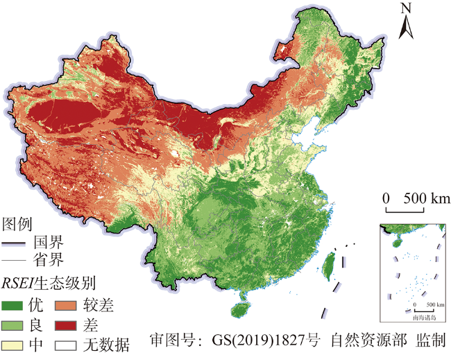
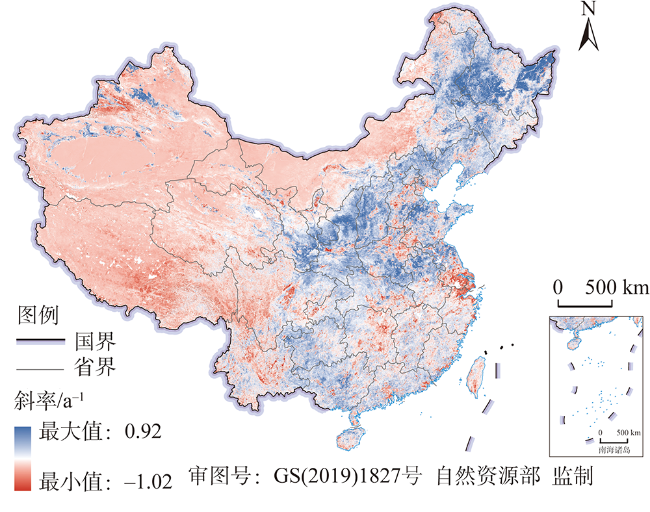
Since the beginning of the 21st century, China has responded to a national land-system sustainability emergency via an integrated portfolio of large-scale programmes. A series of ecological restoration projects and land regulating and planning policies have been implemented for sustainable development, which substantially improved the security status of the country's ecology. However, comprehensive assessments of the ecological status based on objective data and framework are still limited. Remote sensing-based ecological index (RSEI) has been proposed as an objective and effective approach for assessing ecological security on a regional scale. However, a national scale application has not been conducted yet. Here we generated the annual RSEI products from 2000 to 2019 by using four indicators (Normalized Difference Vegetation Index (NDVI), Normalized Difference Soil Index (NDSI), Wetness Index (Wet), and Land Surface Temperature (LST) based on Moderate Resolution Imaging Spectroradiometer (MODIS) data as well as the Google Earth Engine (GEE)-a cloud computing platform. The results showed that the multi-year average RSEI showed higher values in the southeast coastal regions compared with the northwestern regions, the regions with superior hydrothermal conditions have high RSEI values, while the arid and semi-arid inland areas with higher elevations and cold-dry climates have low RSEI values and fragile ecological conditions. In general, the whole country experienced a significant improvement of RSEI, and all the provincial-level regions in China, except Shanghai, Tibet, and Macao, have shown an increasing RSEI. The three provinces with the fastest growing rates were Shanxi, Shaanxi, and Hebei, with increases of 0.29, 0.25, and 0.19, respectively. The RSEI increased significantly in the Northeast China Plain, Loess Plateau, south and north of the North China Plain, the north of the middle and lower reaches of the Yangtze River Plain, and the south of the Junggar Basin in the northwest desert region, while the RSEI decreased in the Tianshan Mountain range, the southwest of the Qinghai-Tibet Plateau, the central part of the North China Plain and the Yangtze River Delta. This study quantitatively evaluated the macro patterns of RSEI changes based on GEE since 2000, and expecte to support decision making on land use management and ecological protection.
HE Ying-li , YOU Nan-shan , CUI Yao-ping , XIAO Tong , HAO Yuan-yuan , DONG Jin-wei . Spatio-temporal changes in remote sensing-based ecological index in China since 2000[J]. JOURNAL OF NATURAL RESOURCES, 2021 , 36(5) : 1176 -1185 . DOI: 10.31497/zrzyxb.20210507
表1 20年间RSEI增加最多和减少最多的前三个省(市、区)Table 1 The three provinces with the fastest increase and decrease change of RSEI in China from 2000 to 2019 |
| 省(市、区) | 2000年 | 2005年 | 2010年 | 2015年 | 2019年 | 20年间差值 |
|---|---|---|---|---|---|---|
| 山西 | 0.20 | 0.34 | 0.41 | 0.50 | 0.50 | 0.29 |
| 河北 | 0.33 | 0.43 | 0.48 | 0.55 | 0.52 | 0.19 |
| 甘肃 | -0.06 | -0.02 | 0.01 | 0.02 | 0.06 | 0.12 |
| 西藏 | -0.05 | -0.05 | -0.05 | -0.08 | -0.06 | -0.01 |
| 澳门 | 0.40 | 0.37 | 0.45 | 0.47 | 0.38 | -0.02 |
| 上海 | 0.83 | 0.68 | 0.65 | 0.66 | 0.68 | -0.14 |
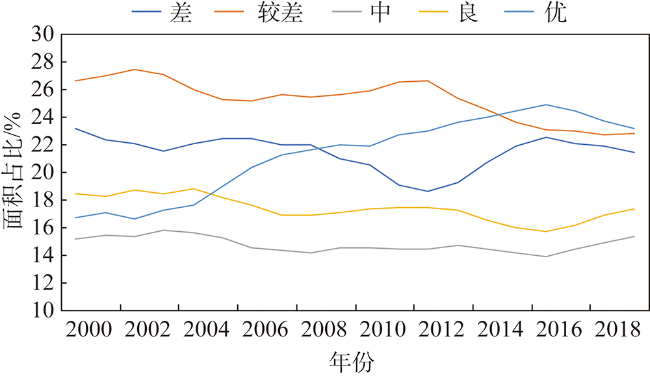
表2 2000—2019年每五年生态状况变化面积及占比Table 2 Change area and proportion of RSEI in China in every five years from 2000 to 2019 |
| 级别 | 2000—2005年 | 2005—2010年 | 2010—2015年 | 2015—2019年 | ||||
|---|---|---|---|---|---|---|---|---|
| 面积/万hm2 | 百分比/% | 面积/万hm2 | 百分比/% | 面积/万hm2 | 百分比/% | 面积/万hm2 | 百分比/% | |
| Ⅰ | 69 | 0 | 23 | 0 | 92 | 0 | 1 | 0 |
| Ⅱ | 5184 | 6 | 4146 | 4 | 5431 | 6 | 69 | 7 |
| Ⅲ | 76117 | 81 | 77861 | 83 | 67253 | 72 | 782 | 84 |
| Ⅳ | 11960 | 13 | 11289 | 12 | 19216 | 21 | 82 | 9 |
| Ⅴ | 107 | 0 | 181 | 0 | 1466 | 2 | 1 | 0 |
注:Ⅰ、Ⅱ、Ⅲ、Ⅳ和Ⅴ表示生态状况的变化级别分别为明显变差、变差、不变、变好和明显变好。 |
表3 2000—2019年每五年生态状况变化面积转移矩阵Table 3 Transition matrix of the RSEI in China in every five years from 2000 to 2019 (万hm2) |
| 时段/年 | 生态级别 | 差 | 较差 | 中 | 良 | 优 |
|---|---|---|---|---|---|---|
| 2000—2005 | 差 | 17709 | 1199 | 3 | 0 | 0 |
| 较差 | 1768 | 18673 | 1043 | 21 | 2 | |
| 中 | 10 | 2862 | 9085 | 1242 | 38 | |
| 良 | 0 | 63 | 3005 | 11996 | 1374 | |
| 优 | 0 | 1 | 25 | 3569 | 13844 | |
| 2005—2010 | 差 | 16641 | 680 | 2 | 0 | 0 |
| 较差 | 2264 | 18872 | 933 | 8 | 0 | |
| 中 | 5 | 1866 | 9593 | 1072 | 11 | |
| 良 | 1 | 86 | 2659 | 11597 | 1199 | |
| 优 | 0 | 7 | 72 | 3787 | 16239 | |
| 2010—2015 | 差 | 16509 | 2084 | 2 | 0 | 0 |
| 较差 | 794 | 17746 | 1824 | 14 | 1 | |
| 中 | 18 | 2114 | 8463 | 1530 | 19 | |
| 良 | 2 | 127 | 2195 | 10627 | 1269 | |
| 优 | 0 | 8 | 70 | 3383 | 18823 | |
| 2015—2019 | 差 | 17062 | 1059 | 3 | 1 | 0 |
| 较差 | 1526 | 16757 | 1147 | 58 | 1 | |
| 中 | 6 | 2507 | 8916 | 1767 | 53 | |
| 良 | 0 | 52 | 2041 | 10776 | 2488 | |
| 优 | 0 | 1 | 21 | 1607 | 19739 |
| [1] |
|
| [2] |
叶亚平, 刘鲁君. 中国省域生态环境质量评价指标体系研究. 环境科学研究, 2000, ( 3):33-36.
[
|
| [3] |
傅伯杰. 中国各省区生态环境质量评价与排序. 中国人口·资源与环境, 1992,2(2):48-54.
[
|
| [4] |
厉彦玲, 朱宝林, 王亮, 等. 基于综合指数法的生态环境质量综合评价系统的设计与应用. 测绘科学, 2005, ( 1):89-91.
[
|
| [5] |
徐涵秋. 区域生态环境变化的遥感评价指数. 中国环境科学, 2013,33(5):889-897.
[
|
| [6] |
陈炜, 黄慧萍, 田亦陈, 等. 基于Google Earth Engine平台的三江源地区生态环境质量动态监测与分析. 地球信息科学学报, 2019,21(9):1382-1391.
[
|
| [7] |
吴宜进, 赵行双, 奚悦, 等. 基于MODIS的2006—2016年西藏生态质量综合评价及其时空变化. 地理学报, 2019,74(7):1438-1449.
[
|
| [8] |
吴全, 范海娇, 徐艳红. 锡林郭勒盟生态状况等级区划分研究. 内蒙古师范大学学报: 哲学社会科学版, 2015,44(4):147-151.
[
|
| [9] |
|
| [10] |
|
| [11] |
|
| [12] |
|
| [13] |
|
| [14] |
|
| [15] |
|
| [16] |
|
| [17] |
阿多, 赵文吉, 宫兆宁, 等. 1981—2013华北平原气候时空变化及其对植被覆盖度的影响. 生态学报, 2017,37(2):576-592.
[
|
| [18] |
陈万旭, 李江风, 朱丽君. 长江中游地区生态系统服务价值空间分异及敏感性分. 自然资源学报, 2019,34(2):325-337.
[
|
| [19] |
道日娜. 气候与土地利用变化对三北地区植被NDVI的影响研究. 呼和浩特: 内蒙古师范大学, 2019.
[
|
| [20] |
张宝庆, 吴普特, 赵西宁. 近30 a黄土高原植被覆盖时空演变监测与分析. 农业工程学报, 2011,27(4):287-293, 400.
[
|
| [21] |
张文强, 孙从建, 李新功. 晋西南黄土高原区植被覆盖度变化及其生态效应评估. 自然资源学报, 2019,34(8):1748-1758.
[
|
| [22] |
胡振通. 中国草原生态补偿机制: 基于内蒙甘肃两省(区)的实证研究. 北京: 中国农业大学, 2016.
[
|
| [23] |
邵全琴, 樊江文, 刘纪远, 等. 三江源生态保护和建设一期工程生态成效评估. 地理学报, 2016,71(1):3-20.
[
|
| [24] |
邵全琴, 刘纪远, 黄麟, 等. 2005—2009年三江源自然保护区生态保护和建设工程生态成效综合评估. 地理研究, 2013,32(9):1645-1656.
[
|
| [25] |
李付杰, 孙倩莹, 王世曦, 等. 2000—2015年三江源区生态系统服务评估. 环境工程技术学报, 2020,10(5):786-797.
[
|
| [26] |
刘纪远, 徐新良, 邵全琴. 近30年来青海三江源地区草地退化的时空特征. 地理学报, 2008,63(4):364-376.
[
|
| [27] |
李汝资, 宋玉祥, 李雨停, 等. 近10 a来东北地区生态环境演变及其特征研究. 地理科学, 2013,33(8):935-941.
[
|
| [28] |
张宇硕, 吴殿廷, 吕晓. 土地利用/覆盖变化对生态系统服务的影响: 空间尺度视角的研究综述. 自然资源学报, 2020,35(5):1172-1189.
[
|
/
| 〈 |
|
〉 |