
JOURNAL OF NATURAL RESOURCES >
Classification and extraction of forest land in China based on the perspective of "Production-Living-Ecology"
Received date: 2020-05-06
Revised date: 2020-08-11
Online published: 2021-07-28
Copyright
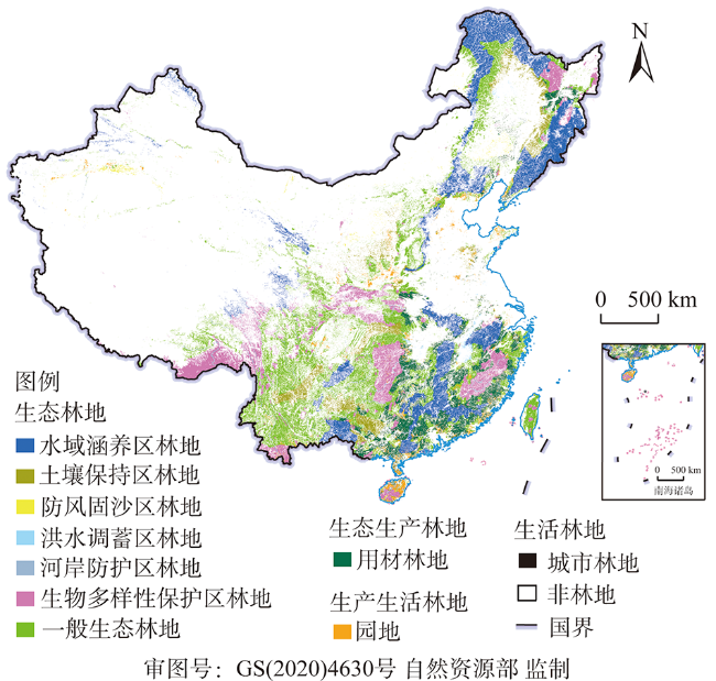
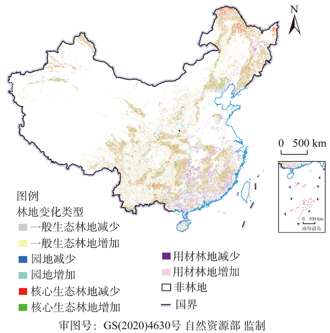
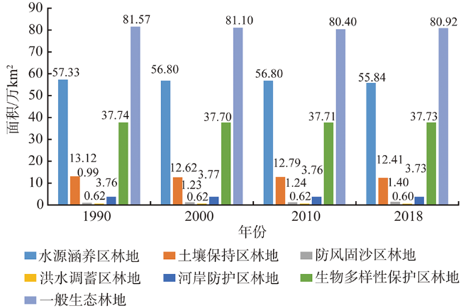
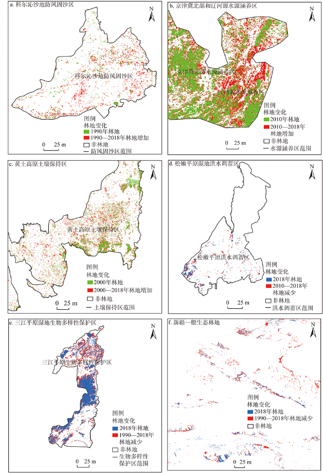
Forest land has multiple functions. In ecological, production or living priority areas, forest land plays different roles. The traditional forest land classification is difficult to take into account the regional dominant function and development orientation. There is still a lack of quantitative description of the spatial and temporal characteristics of forest land in different functional areas. This paper establishes a forest land classification system based on the perspective of "Production-Living-Ecology". Using land use map, functional zoning, vegetation phenological characteristics and statistical data, through thematic map superposition, remote sensing recognition and decision tree classification technology, various types of forest land are extracted. The results show that from 1990 to 2018, forest land in ecological priority area decreased by 24900 km 2, but decreased slowly after 2000, and that the remote sensing area of forest land in China in 2018 was 2.2818 million km 2. Local forest lands in core ecological functional areas such as wind prevention and sand fixation, water conservation and soil conservation areas were expanded, mainly in some grasslands and sandy areas in Inner Mongolia, Northwest Hebei and the Loess Plateau. In the Northeast Region, Southwest Region and Northern Xinjiang, forest land was converted into cultivated land or grassland. The decrease of forest land in biodiversity reserve was the smallest. The timber land decreased slowly after 2010. The garden land expanded rapidly in the southeast, mainly from timber land and cultivated land. The urban forest land is increasing rapidly in Guangdong, Zhejiang, Jiangsu and Beijing. The study shows that forest land with core ecological function is partially restored in the scope of the ecological restoration project and nature reserve, but the severe man-made disturbance still leads to a large decrease in its overall area. It is suggested that the ecological forest land should be restored and the dominant ecological value should be promoted according to regional differences.
YU Zhu-xiao , ZHANG Hong-qi , XU Er-qi . Classification and extraction of forest land in China based on the perspective of "Production-Living-Ecology"[J]. JOURNAL OF NATURAL RESOURCES, 2021 , 36(5) : 1136 -1148 . DOI: 10.31497/zrzyxb.20210504
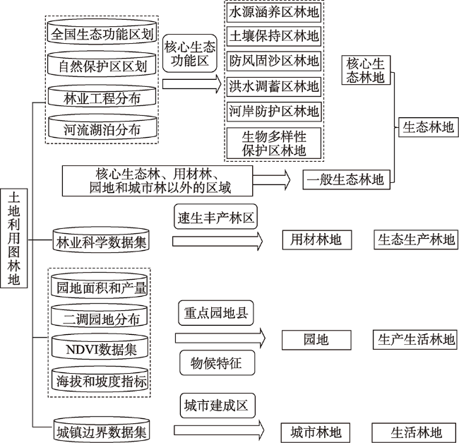
表1 基于“三生”视角的林地分类体系Table 1 Forest land classification system based on the perspective of "Production-Living-Ecology" |
| 一级分类 | 二级分类 | |
|---|---|---|
| 生态林地 | 核心生态林地 | 水源涵养区林地 |
| 土壤保持区林地 | ||
| 防风固沙区林地 | ||
| 洪水调蓄区林地 | ||
| 河岸防护区林地 | ||
| 生物多样性保护区林地 | ||
| 一般生态林地 | ||
| 生态生产林地 | 用材林地 | |
| 生产生活林地 | 园地 | |
| 生活林地 | 城市林地 | |
表2 中国各农业生态区园地提取方法Table 2 Extraction schemes of garden land for different eco-agricultural regions in China |
| 序号 | 中国农业生态区 | 园地主要类型 | 园地NDVI物候判别依据 | 海拔判别依据/m |
|---|---|---|---|---|
| 1 | 冀鲁豫低洼平原农业区/燕山太行山山麓平原农业区/山东丘陵农林区 | 果园(苹果,其次梨和葡萄) | 4-5月增速最大 5月<6月 | —/<1000/<500 |
| 2 | 辽宁平原丘陵农林区 | 果园(苹果,其次梨和葡萄) | 5-6月增速最大 10-11月降速最大 | <200 |
| 3 | 长城沿线牧区 | 果园(苹果,其次梨和葡萄) | 4-5月增速最大 6-9月振幅>0.10 | <1500 |
| 4 | 晋东豫西丘陵山地农林牧区 | 果园(苹果,其次梨和葡萄) | 3-4月增速最大 5-9月振幅>0.12 | <1000 |
| 5 | 汾渭谷地农业区 | 果园(苹果)和少量桑园 | 3-4月增速最大 5月<6月 5-10月振幅>0.13 | <1000 |
| 6 | 晋陕甘黄土丘陵沟壑牧林农区 | 果园(苹果) | 6月<7月 6-9月振幅>0.12 | <1500 |
| 7 | 陇中青东丘陵农牧区 | 果园(苹果) | 5-10月振幅<0.05 全年振幅<0.39 | <1500 |
| 8 | 秦岭大巴山林农区/淮北平原 | 果园(柑橘、梨) | 3-4月增速最大 5月<6月 | <500 |
| 9 | 豫皖鄂平原山地农林区 | 果园(苹果) | 3-4月增速最大 5月<6月 全年振幅>0.59 | <200 |
| 10 | 长江下游平原丘陵农畜水产区/长江中游平原农业水产区 | 果园(柑橘) | 4-5月增速最大 4月<5月<6月 7-9月振幅>0.15 | — |
| 11 | 浙闽丘陵山地林农区 | 果园(柑橘)和 茶园 | 7月<8月 9月波峰 | <1000 |
| 12 | 川鄂湘黔边境林农牧区/四川盆地农林区 | 果园(柑橘) | 4月<5月 全年振幅>0.51 | <1000/<500 |
| 13 | 江南丘陵山地农林区/闽南粤中农林水产区/南岭丘陵山地林农区 | 果园(柑橘) | 3月<4月 7月<8月 11-12月降速最大 | <400/<500/<500 |
| 14 | 粤西桂南农林区 | 果园(柑橘、香蕉) | 3-4月增速最大 7月<8月 11-12月降速最大 | <1000 |
| 15 | 黔桂高原山地林农区 | 茶园 | 3月、8月波谷 | 800~1400 |
| 16 | 川滇高原山地农林区 | 桑园 | 6月、7月波谷 | <2200 |
| 17 | 滇南农林区/雷琼及南海诸岛农林区 | 橡胶 | 3月波谷 9月波峰 | <300 |
| 18 | 南疆农牧区 | 果园(红枣) | 4-5月增速最大 5月<6月 7月波峰 | <1500 |
表3 1990—2018年林地各类型面积转移Table 3 Area transfer of forest land types from 1990 to 2018 (万km2) |
| 一级分类 | 二级分类 | 耕地 | 林地 | 草地 | 水域 | 建设用地 | 未利用地 | 合计 | |
|---|---|---|---|---|---|---|---|---|---|
| 生态林地 | 核心生 态林地 | 水源涵养区林地 | 0.19 | — | -0.72 | 0.05 | 0.22 | 1.75 | 1.49 |
| 土壤保持区林地 | 0.52 | — | -0.02 | 0.04 | 0.06 | 0.11 | 0.71 | ||
| 防风固沙区林地 | -0.03 | — | -0.34 | 0 | 0 | -0.04 | -0.41 | ||
| 洪水调蓄区林地 | 0.01 | — | 0 | 0 | 0.01 | 0 | 0.02 | ||
| 河岸防护区林地 | -0.01 | — | -0.05 | 0.04 | 0.05 | 0.01 | 0.04 | ||
| 生物多样性保护区林地 | 0.21 | — | -0.61 | 0.03 | 0.11 | 0.27 | 0.01 | ||
| 一般生态林地 | 0.02 | 0.55 | -1.30 | 0.12 | 0.69 | 0.56 | 0.64 | ||
| 生态生产林地 | 用材林地 | 0.18 | 0.63 | -0.13 | 0.04 | 0.26 | -0.02 | 0.96 | |
| 生产生活林地 | 园地 | -1.35 | -1.30 | -0.35 | -0.02 | 0.15 | -0.03 | -2.90 | |
| 生活林地 | 城市林地 | -0.41 | -0.34 | -0.03 | -0.02 | -0.07 | 0 | -0.87 | |
注:正数为转出,负数为转入。 |
| [1] |
|
| [2] |
谢余初, 巩杰, 齐姗姗, 等. 基于InVEST模型的白龙江流域水源供给服务时空分异. 自然资源学报, 2017,32(8):1337-1347.
[
|
| [3] |
|
| [4] |
李婕. 浙江省休闲观光果园空间结构研究. 杭州: 浙江农林大学, 2013.
[
|
| [5] |
张红旗, 许尔琪, 朱会义. 中国“三生用地”分类及其空间格局. 资源科学, 2015,37(7):1332-1338.
[
|
| [6] |
|
| [7] |
|
| [8] |
宋永昌, 阎恩荣, 宋坤. 再议中国的植被分类系统. 植物生态学报, 2017,41(2):269-278.
[
|
| [9] |
国家林业局. 森林资源规划设计调查主要技术规定. 2003.
[ State Forestry Administration of China. Main technical regulations for forest resources planning and design investigation. 2003.]
|
| [10] |
国土资源部. 土地利用现状分类(GB/T21010-2017). 2017.
[ Ministry of Land and Resources of China. Land use status classification(GB/T21010-2017). 2017.]
|
| [11] |
唐立娜, 王庆礼, 代力民, 等. 辽宁东部山区林地生态分类系统. 应用生态学报, 2008,19(1):20-24.
[
|
| [12] |
|
| [13] |
|
| [14] |
|
| [15] |
|
| [16] |
许尔琪, 张红旗. 中国核心生态空间的现状、变化及其保护研究. 资源科学, 2015,37(7):1322-1331.
[
|
| [17] |
|
| [18] |
毛世平. 西藏自治区生态空间的分类与范围及人类活动影响. 自然资源学报, 2019,34(10):2163-2174.
[
|
| [19] |
王强, 张勃, 戴声佩, 等. 基于GIMMS AVHRR NDVI数据的三北防护林工程区植被覆盖动态变化. 资源科学, 2011,33(8):199-206.
[
|
| [20] |
徐伟燕, 孙睿, 金志凤. 基于资源三号卫星影像的茶树种植区提取. 农业工程学报, 2016,32(s1):161-168.
[
|
| [21] |
凡宸, 叶有华, 邓焕祥, 等. 基于HJ-1-A/B数据提取城市绿地信息的应用研究. 生态科学, 2014,33(3):568-573.
[
|
| [22] |
刘继来, 刘彦随, 李裕瑞. 中国“三生空间”分类评价与时空格局分析. 地理学报, 2017,72(7):1290-1304.
[
|
| [23] |
环境保护部, 中国科学院. 全国生态功能区划(修编版). 2015.
[ Ministry of Environmental Protection, Chinese Academy of Sciences. National ecological function regionalization (revised edition). 2015.]
|
| [24] |
中国林业科学研究院, 中国测绘科学研究院. 林业科学数据集(第一卷). 北京: 中国林业出版社, 2005.
[ Chinese Academy of Forestry, Chinese Academy of Surveying and Mapping. Forestry Science Data Set (Volume I). Beijing: China Forestry Publishing House, 2005.]
|
| [25] |
王龑, 田庆久, 黄彦, 等. 基于HJ星CCD遥感数据的落叶阔叶林NDVI差值速率识别模型. 光谱学与光谱分析, 2013,33(4):1018-1022.
[
|
| [26] |
|
| [27] |
刘建光, 李红, 孙丹峰, 等. MODIS土地利用/覆被多时相多光谱决策树分类. 农业工程学报, 2010,26(10):312-318.
[
|
| [28] |
|
| [29] |
|
| [30] |
|
| [31] |
|
| [32] |
|
| [33] |
|
| [34] |
|
| [35] |
住房和城乡建设部. 中国城乡建设统计年鉴. 2018.
[ Ministry of Housing and Urban-Rural Development. Statistical yearbook of urban and rural construction in China. 2018.]
|
/
| 〈 |
|
〉 |