
JOURNAL OF NATURAL RESOURCES >
Spatial pattern evolution of cities and influencing factors in the historical Yellow River Basin
Received date: 2020-06-08
Request revised date: 2020-07-13
Online published: 2021-03-28
Copyright
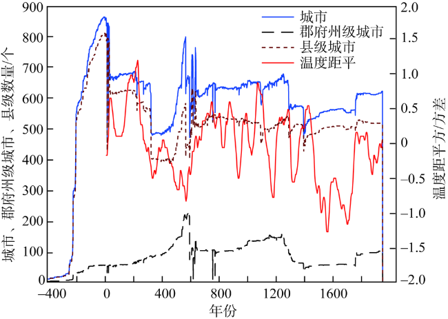
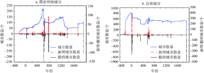
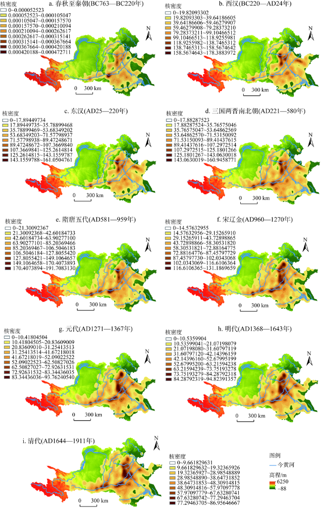
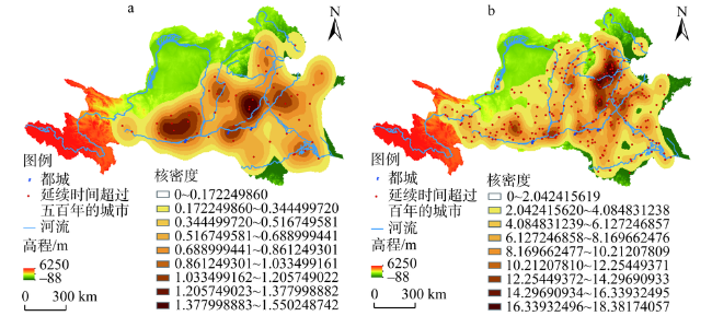
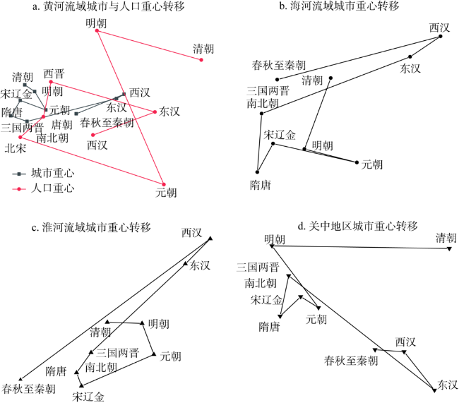
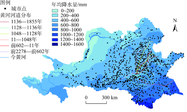
The spatial pattern evolution of the cities in the historical Yellow River Basin will help us understand the characteristics and development context of human settlements, which plays a key role in ecological protection and urban development in the Yellow River Basin today. This article uses the time series data of cities (BC763-AD1911) in the CHGIS database of Harvard University, the elevation data of STRM, the regional data of nine major basins in China, and the historical population data. It studies the spatio-temporal pattern evolution of cities in the Yellow River Basin, as well as the influencing factors. The results show that: (1) The changes in the number of cities can be divided into five stages. (2) The first level continous stable region includes the high-density urban area in northern Henan with present Anyang as the center, high-density urban area in Guanzhong with present Xi'an as the center, and the secondary high-density area with Jinan, Taiyuan and Luoyang as the center. The second level continuous stable region includes five important city belts, namely, Weihe River city belt, Fenhe River city belt, northern foot city belt of central Shandong mountainous region, eastern foot city belt of Taihang Mountains and Grand Canal city belt. (3) The average distance of city gravity migration is 32 km, and the average distance of population gravity migration is 95.78 km. The distribution of cities and population is closely related. (4) Natural factors such as temperature and precipitation, elevation, distance from the rivers, downstream avulsions of the Yellow River, as well as human factors such as wars, capital transfer and canals, had jointly influenced the spatial and temporal distribution of cities in the Yellow River Basin.
WANG Chang-song , DUAN Yun-xin , ZHANG Ran . Spatial pattern evolution of cities and influencing factors in the historical Yellow River Basin[J]. JOURNAL OF NATURAL RESOURCES, 2021 , 36(1) : 69 -86 . DOI: 10.31497/zrzyxb.20210105
图5 历史时期黄河流域城市重心与人口重心转移Fig. 5 Transfer of city gravity and population gravity in the Yellow River Basin |
表1 历史时期黄河流域城市重心与人口重心转移Table 1 Transfer of city gravity and population gravity in the Yellow River Basin in the historical period |
| 朝代 | 城市重心 | 人口重心 | |||||||
|---|---|---|---|---|---|---|---|---|---|
| 经度/(°) | 纬度/(°) | 迁移距离/km | 迁移方向 | 经度/(°) | 纬度/(°) | 迁移距离/km | 迁移方向 | ||
| 春秋至秦朝 | 114.45 | 35.86 | — | — | — | — | — | — | |
| 西汉 | 115.03 | 36 | 54.4 | 东北 | 114.65 | 35.7 | — | — | |
| 东汉 | 114.94 | 35.97 | 8.8 | 西南 | 115.4 | 35.87 | 70.09 | 东北 | |
| 三国两晋南北朝 | 113.86 | 35.8 | 98.9 | 西南 | 114.15 | 36.1 | 115.48 | 西北 | |
| 隋唐 | 113.67 | 35.84 | 18.1 | 西北 | 114.06 | 35.83 | 30.35 | 西南 | |
| 宋辽金 | 113.78 | 35.96 | 16.4 | 东北 | 113.78 | 35.68 | 30.37 | 西南 | |
| 元朝 | 114.09 | 35.89 | 28.8 | 东南 | 115.51 | 35.32 | 161.23 | 东南 | |
| 明朝 | 113.95 | 36.02 | 19.6 | 西北 | 114.70 | 36.48 | 147.94 | 西北 | |
| 清朝 | 113.83 | 36.07 | 12.1 | 西北 | 115.96 | 36.26 | 114.98 | 东南 | |
表2 海河流域、淮河流域和关中地区城市重心转移Table 2 Transfer of city gravity in the Haihe and Huaihe river basins, and Guanzhong area |
| 朝代 | 海河流域 | 淮河流域 | 关中地区 | |||||||||||
|---|---|---|---|---|---|---|---|---|---|---|---|---|---|---|
| 经度/(°) | 纬度/(°) | 迁移 距离/km | 迁移 方向 | 经度/(°) | 纬度/(°) | 迁移 距离/km | 迁移 方向 | 经度/(°) | 纬度/(°) | 迁移 距离/km | 迁移 方向 | |||
| 西汉之前 | 114.98 | 37.83 | — | — | 116.33 | 34.29 | — | — | 108.88 | 34.59 | — | — | ||
| 西汉 | 115.22 | 37.89 | 21.8 | 东北 | 116.99 | 34.71 | 76.3 | 东北 | 108.91 | 34.58 | 2.9 | 东 | ||
| 东汉 | 115.17 | 37.86 | 5.1 | 西南 | 116.91 | 34.63 | 11.4 | 西南 | 108.94 | 34.56 | 4 | 东南 | ||
| 魏晋南北朝 | 114.96 | 37.78 | 20.9 | 西南 | 116.58 | 34.37 | 42 | 西南 | 108.78 | 34.63 | 16.5 | 西北 | ||
| 隋唐 | 114.95 | 37.69 | 9.7 | 南 | 116.53 | 34.31 | 8.2 | 西南 | 108.77 | 34.61 | 2.8 | 西南 | ||
| 宋朝 | 114.98 | 37.73 | 5.2 | 东北 | 116.54 | 34.27 | 4.7 | 东南 | 108.8 | 34.62 | 2.5 | 东北 | ||
| 元朝 | 115.1 | 37.71 | 11 | 东南 | 116.8 | 34.36 | 25.3 | 东北 | 108.82 | 34.61 | 1.9 | 东南 | ||
| 明朝 | 115.02 | 37.73 | 7 | 西北 | 116.75 | 34.45 | 11 | 西北 | 108.76 | 34.65 | 6.2 | 西北 | ||
| 清朝 | 115.06 | 37.83 | 12.2 | 东北 | 116.63 | 34.46 | 11.1 | 西 | 108.96 | 34.65 | 17.8 | 东 | ||
表3 历史时期黄河流域城市与河流距离分布Table 3 Distance between cities and rivers in the Yellow River Basin in the historical period |
| 与河流距离/km | 0~1 | 1~2 | 2~3 | >3 |
|---|---|---|---|---|
| 城市数量/个 | 2242 | 241 | 22 | 9 |
表4 历史时期黄河流域城市海拔高度分布Table 4 Altitude of cities in the Yellow River Basin in the historical period |
| 海拔高度/m | 0~500 | 500~1000 | 1000~1500 | 1500~2000 | 2000~2500 | 2500~3000 | >3000 |
|---|---|---|---|---|---|---|---|
| 城市数量/个 | 1761 | 388 | 274 | 59 | 21 | 9 | 2 |
表5 城市数量与气温的相关性分析结果Table 5 The correlation analysis between the number of cities and temperature |
| 城市数量 | 气温 | ||
|---|---|---|---|
| 城市数量 | 皮尔逊相关性 | 1 | 0.354* |
| 显著性(双尾) | 0.000 | ||
| 个案数 | 2676 | 1908 | |
| 气温 | 皮尔逊相关性 | 0.354* | 1 |
| 显著性(双尾) | 0.000 | ||
| 个案数 | 1908 | 1908 | |
注:*表示在0.01水平(双尾)相关性显著。 |
| [1] |
|
| [2] |
|
| [3] |
|
| [4] |
|
| [5] |
|
| [6] |
|
| [7] |
|
| [8] |
|
| [9] |
张光直. 关于中国初期“城市”这个概念. 文物, 1985, (2):61-67.
[
|
| [10] |
任式楠. 中国史前城址考察. 考古, 1998, (1):1-16.
[
|
| [11] |
焦南峰, 张仲立, 段清波, 等. 陕西秦汉考古五十年综述. 考古与文物, 2008, (6):96-160.
[
|
| [12] |
侯仁之. 从红柳河上的古城废墟看毛乌素沙漠的变迁. 文物, 1973, (1):35-41.
[
|
| [13] |
史念海. 两千三百年来鄂尔多斯高原和河套平原农林牧地区的分布及其变迁. 北京师范大学学报, 1980, (6):1-14.
[
|
| [14] |
侯甬坚, 周杰, 王燕新. 北魏(AD386—534)鄂尔多斯高原的自然一人文景观. 中国沙漠, 2001, (2):188-194.
[
|
| [15] |
邓辉, 夏正楷, 王琫瑜. 从统万城的兴废看人类活动对生态环境脆弱地区的影响. 中国历史地理论丛, 2001, (2):104-113.
[
|
| [16] |
王尚义, 董靖保. 统万城的兴废与毛乌素沙地之变迁. 地理研究, 2001,20(3):347-353.
[
|
| [17] |
王乃昂, 黄银洲, 何彤慧, 等. 鄂尔多斯高原古城夯层沙的环境解释. 地理学报, 2006, (9):937-945.
[
|
| [18] |
邓辉, 舒时光, 宋豫秦, 等. 明代以来毛乌素沙地流沙分布南界的变化. 科学通报, 2007, (21):2556-2563.
[
|
| [19] |
侯甬坚. 鄂尔多斯高原自然背景和明清时期的土地利用. 中国历史地理论丛, 2007, (4):28-39.
[
|
| [20] |
宋乃平, 张凤荣. 鄂尔多斯农牧交错土地利用格局的演变与机理. 地理学报, 2007,62(12):1299-1308.
[
|
| [21] |
冯文勇. 鄂尔多斯高原及毗邻地区历史城市地理研究. 兰州: 兰州大学, 2008.
[
|
| [22] |
陈隆文. 水患与黄河流域古代城市的变迁研究: 以河南汜水县城为研究对象. 河南大学学报: 社会科学版, 2009,49(5):102-109.
[
|
| [23] |
吴朋飞, 刘德新. 审视与展望: 黄河变迁对城市的影响研究述论. 云南大学学报: 社会科学版, 2020,19(1):69-77.
[
|
| [24] |
孔祥勇, 骆子昕. 北魏洛阳的城市水利. 中原文物, 1988, (4):83-86.
[
|
| [25] |
黄盛璋. 西安城市发展中的给水问题以及今后水源的利用与开发. 地理学报, 1958, (4):406-426.
[
|
| [26] |
马正林. 论西安城址选择的地理基础. 陕西师大学报: 哲学社会科学版, 1990, (1):19-24.
[
|
| [27] |
王炬. 谷水与洛阳诸城址的关系初探. 考古, 2011, (10):79-84.
[
|
| [28] |
陈代光. 运河的兴废与开封的盛衰. 中州学刊, 1983, (6):127-130.
[
|
| [29] |
史念海. 汉唐长安城与生态环境. 中国历史地理论丛, 1998, (1):1-18.
[
|
| [30] |
杨思植, 杜甫亭. 西安地区河流及水系的历史变迁. 陕西师大学报: 哲学社会科学版, 1985, (3):91-97.
[
|
| [31] |
戴培超, 沈正平. 水环境变迁与徐州城市兴衰研究. 人文地理, 2013,28(6):55-61.
[
|
| [32] |
马正林. 由历史上西安城的供水探讨今后解决水源的根本途径. 陕西师范大学学报: 哲学社会科学版, 1981, (4):70-78.
[
|
| [33] |
李亚. 历史时期濒水城市水灾问题初探: 以北宋开封为例. 华中科技大学学报: 社会科学版, 2003, (5):120-124.
[
|
| [34] |
宋洋, 朱道林, 张立新, 等. 2000年以来黄河流域土地市场化时空格局演变及驱动因素. 自然资源学报, 2020,35(4):799-813.
[
|
| [35] |
张冉, 王义民, 畅建霞, 等. 基于水资源分区的黄河流域土地利用变化对人类活动的响应. 自然资源学报, 2019,34(2):274-287.
[
|
| [36] |
王守春. 历史地理学研究的新的开拓. 中国历史地理论丛, 1999, (1):235-238.
[
|
| [37] |
史红帅. 近70年来中国历史城市地理研究进展. 中国历史地理论丛, 2020,35(1):5-24.
[
|
| [38] |
侯仁之. 北京都市发展过程中的水源问题. 北京大学学报: 人文科学, 1955, (1):142-168.
[
|
| [39] |
马正林. 中国城市的选址与河流. 陕西师范大学学报: 哲学社会科学版, 1999, (4):83-87.
[
|
| [40] |
何一民. 清代城市空间分布研究. 成都: 巴蜀书社, 2018: 325-326.
[
|
| [41] |
谭其骧. 何以黄河在东汉以后会出现一个长期安流的局面: 从历史上论证黄河中游的土地合理利用是消弭下游水害的决定性因素. 学术月刊, 1962, (2):23-35.
[
|
| [42] |
邹逸麟. 历史时期黄河流域的环境变迁与城市兴衰. 江汉论坛, 2006, (5):98-105.
[
|
| [43] |
葛全胜, 刘浩龙, 郑景云, 等. 中国过去2000年气候变化与社会发展. 自然杂志, 2013,35(1):9-20.
[
|
| [44] |
梁方仲. 梁方仲文集: 中国历代户口、田地、田赋统计. 北京: 中华书局, 2008: 1-387.
[
|
| [45] |
吴松弟. 中国人口史(第三卷宋辽金元时期). 上海: 复旦大学出版社, 2005: 283-284.
[
|
| [46] |
(汉)班固. 汉书. 卷28. 北京: 中华书局. 1962: 1523-1674.
[(
|
| [47] |
(明)宋濂, 等. 元史. 卷58-63. 北京: 中华书局. 1976: 1345-1585.
[ (Ming Dynasty)
|
| [48] |
(唐)房玄龄. 晋书. 卷14-15. 北京: 中华书局, 1996: 405-472.
[ (Tang)
|
| [49] |
陆张维, 徐丽华, 吴次芳, 等. 西部大开发战略对于中国区域均衡发展的绩效评价. 自然资源学报, 2013,28(3):361-371.
[
|
| [50] |
陈亚宁, 杨思全. 自然灾害的灰色关联灾情评估模型及应用研究. 地理科学进展, 1999,18(2):158-162.
[
|
| [51] |
肖爱玲. 西汉城市体系的空间演化. 北京: 商务印书馆, 2012: 31-43.
[
|
| [52] |
何一民. 中国城市史纲. 成都: 四川大学出版社, 1994: 12-16.
[
|
| [53] |
水利电力部黄河水利委员会. 人民黄河. 北京: 水利电力出版社, 1959: 34-59.
[ Yellow River Water Conservancy Commission of the Ministry of Water Resources and Electric Power. Yellow River. Beijing: Water Resources and Electric Power Press, 1959: 34-59.]
|
| [54] |
邹逸麟, 张修桂, 王守春. 中国历史自然地理. 北京: 科学出版社, 2013: 203-239, 446-474.
[
|
/
| 〈 |
|
〉 |