
JOURNAL OF NATURAL RESOURCES >
The historical evolution of urban settlements and man-land coupling in Wuding River Basin
Received date: 2020-05-18
Request revised date: 2020-08-18
Online published: 2021-03-28
Copyright
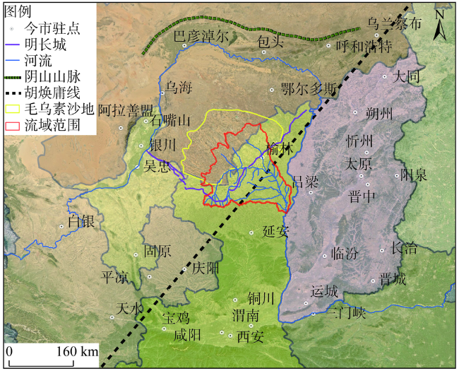
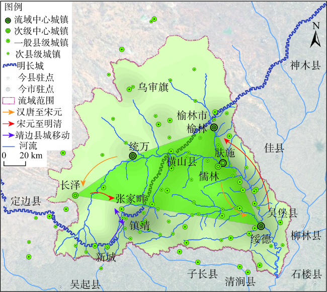
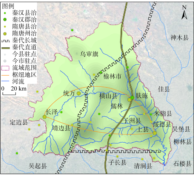
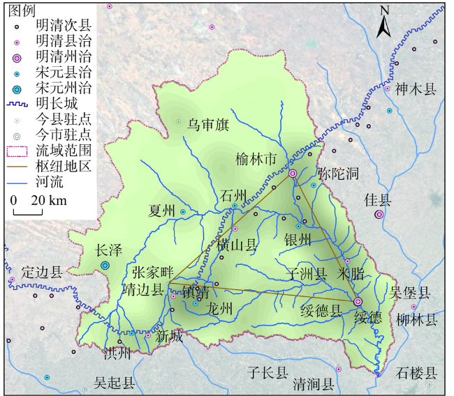
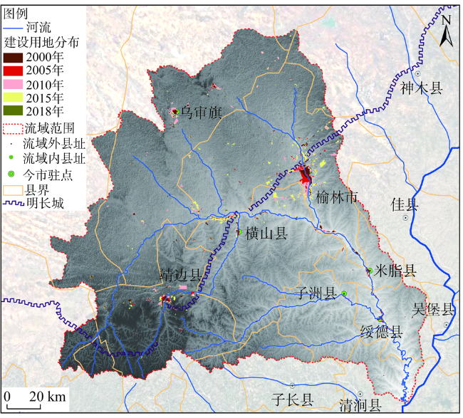
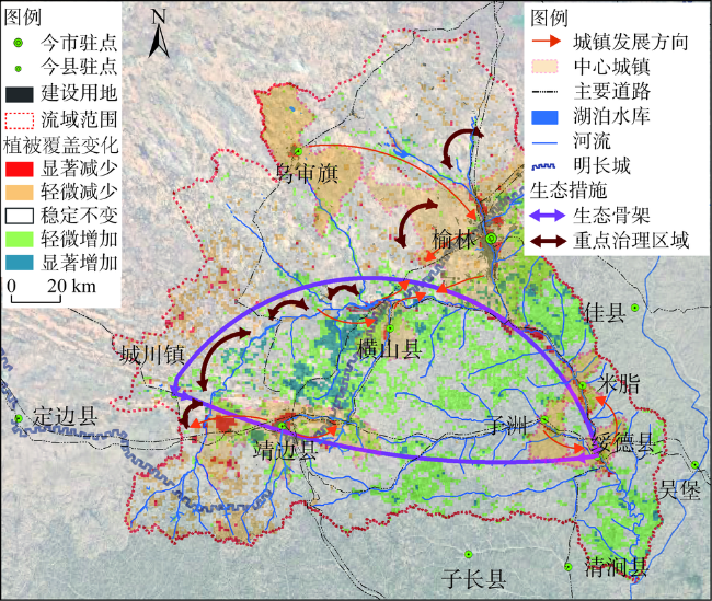
The Wuding River Basin, located in the Loess Plateau of the middle reaches of the Yellow River, is a typical transitional zone and ecologically fragile area in history. Based on the analysis of the historical development process of urban pattern and the coupling relationship between human and land in this process, this paper puts forward the countermeasures and suggestions for the future urban development and ecological protection of the basin in combination with the current situation of urban development. The main findings are as follows: the development and evolution of the urban hub area in the basin was bow shaped in the Tang Dynasty and before, when the natural conditions were better, and the urban spatial layout was mainly based on natural factors; the hub area after the Tang Dynasty presented a triangle pattern, and the urban spatial layout was mainly based on human factors; the contemporary urban pattern of the basin inherited the context of historical development, but the driving force of urban development was mainly based on resources along the Great Wall. The human activities have an impact on the vegetation coverage in some areas; at the same time, the ecological protection policies, such as returning farmland to forests, wind prevention and desertification control, have exerted positive effects. It is suggested that the development of the river basin should be reasonably determined and concentrated around the main cities and towns in combination with the national strategic positioning and regional ecological environment bearing capacity. In addition, the ecological barrier and key prevention and control areas are constructed with the river as the backbone.
TONG Biao , DANG An-rong , ZHOU Hong-yu . The historical evolution of urban settlements and man-land coupling in Wuding River Basin[J]. JOURNAL OF NATURAL RESOURCES, 2021 , 36(1) : 38 -54 . DOI: 10.31497/zrzyxb.20210103
表1 植被覆盖趋势分级参数表Table 1 Parameters of cluster for NDVI changing trends |
| 综合分级 | 分级说明 |
|---|---|
| 显著减少 | S<-0.02,且|Z|>1.64 |
| 轻微减少 | -0.02<S<-0.01,且|Z|>1.28 |
| 基本稳定 | |S|<0.01,或|Z|<1.28 |
| 轻微增加 | 0.01<S<0.02,且|Z|>1.28 |
| 显著增加 | S >0.02,且|Z|>1.64 |
| [1] |
佟彪, 党安荣, 许剑. 300BC-1900AD无定河流域城镇时空格局演变. 地理学报, 2019,74(8):1508-1524.
[
|
| [2] |
侯仁之. 从红柳河上的古城废墟看毛乌素沙漠的变迁. 文物, 1973, (1):35-41.
[
|
| [3] |
史念海. 两千三百年来鄂尔多斯高原和河套平原农林牧地区的分布及其变迁. 北京师范大学学报, 1980, (6):1-14.
[
|
| [4] |
冯文勇, 王乃昂, 何彤慧. 鄂尔多斯高原及毗邻地区历史城市发展的影响因素. 经济地理, 2010,30(3):431-437.
[
|
| [5] |
何彤慧, 王乃昂. 毛乌素沙地: 历史时期环境变化研究. 北京: 人民出版社, 2010.
[
|
| [6] |
韩茂莉. 历史时期无定河流域的土地开发. 中国历史地理论丛, 1990, (2):25-44.
[
|
| [7] |
吕静. 陕西榆林生态环境演变的历史过程考释. 榆林高等专科学校学报, 2003, (2):47-49.
[
|
| [8] |
安介生. 统万城下的“广泽”与“清流”: 历史时期红柳河(无定河上游)谷地环境变迁新探. 历史地理, 2008, (1):242-268.
[
|
| [9] |
李兰, 陈晓键. 快速发展期的西北地区中小城市空间扩展分析与评价: 以陕西省榆林市为例. 生态经济, 2014, (6):109-113.
[
|
| [10] |
沈思思, 陈健, 耿楠森, 等. 快速城镇化地区的城市开发边界划定方法探索: 以榆林市为例. 城市发展研究, 2015, (6):103-111.
[
|
| [11] |
周淑琴, 荆耀栋, 张青峰, 等. 毛乌素沙地植被空间自相关分布模式及变化特征. 应用基础与工程科学学报, 2015, (2):318-330.
[
|
| [12] |
石玉琼, 郑亚云, 李团胜. 榆林地区2000—2014年NDVI时空变化. 生态学杂志, 2018,37(1):211-218.
[
|
| [13] |
杨波, 王全九, 许晓婷, 等. 还林还草工程后榆林市NDVI时空变化趋势. 生态学杂志, 2019,38(6):1839-1848.
[
|
| [14] |
王立新, 刘华民, 杨劼, 等. 毛乌素沙地气候变化及其对植被覆盖的影响. 自然资源学报, 2010,25(12):2030-2039.
[
|
| [15] |
|
| [16] |
谭其骧. 中国历史地图集. 北京: 中国地图出版社, 1982.
[
|
| [17] |
党安荣, 毛其智, 王晓栋. 基于GIS空间分析的北京城市空间发展. 清华大学学报: 自然科学版, 2002, (6):814-817.
[
|
| [18] |
[
|
| [19] |
|
| [20] |
张亮, 丁明军, 张华, 等. 1982—2015年长江流域植被覆盖度时空变化分析. 自然资源学报, 2018,33(12):2084-2097.
[
|
| [21] |
陈彦光. 中国历史的地理枢纽: 中国地缘政治格局成因和影响的历史分析. 信阳师范学院学报: 自然科学版, 2011, (1):85-95.
[
|
| [22] |
葛全胜, 方修琦, 郑景云. 中国历史时期气候变化影响及其应对的启示. 地球科学进展, 2014, (1):23-29.
[
|
| [23] |
金勇强. 宋夏战争与黄土高原地区草原植被的变迁. 干旱区资源与环境, 2010, (7):192-195.
[
|
| [24] |
梁方仲. 中国历代户口、田地、田赋统计. 上海: 上海人民出版社, 1980.
[
|
| [25] |
朱士光. 论我国黄土高原地区生态环境演化特点与可持续发展对策. 中国历史地理论丛, 2000, (3):1-10.
[
|
| [26] |
桑广书. 黄土高原历史时期植被变化. 干旱区资源与环境, 2005, (4):54-58.
[
|
| [27] |
徐玲玲, 延昊, 钱拴. 基于MODIS-NDVI的2000—2018年中国北方土地沙化敏感性时空变化. 自然资源学报, 2020,35(4):925-936.
[
|
| [28] |
杨屹, 胡蝶. 生态脆弱区榆林三维生态足迹动态变化及其驱动因素. 自然资源学报, 2018,33(7):1204-1217.
[
|
/
| 〈 |
|
〉 |
