
JOURNAL OF NATURAL RESOURCES >
Reconstruction of cultivated land pattern in the upper reaches of the Yellow River in the late Northern Song Dynasty:Take Hehuang Valley as an example
Received date: 2020-08-03
Request revised date: 2020-11-18
Online published: 2021-03-28
Copyright
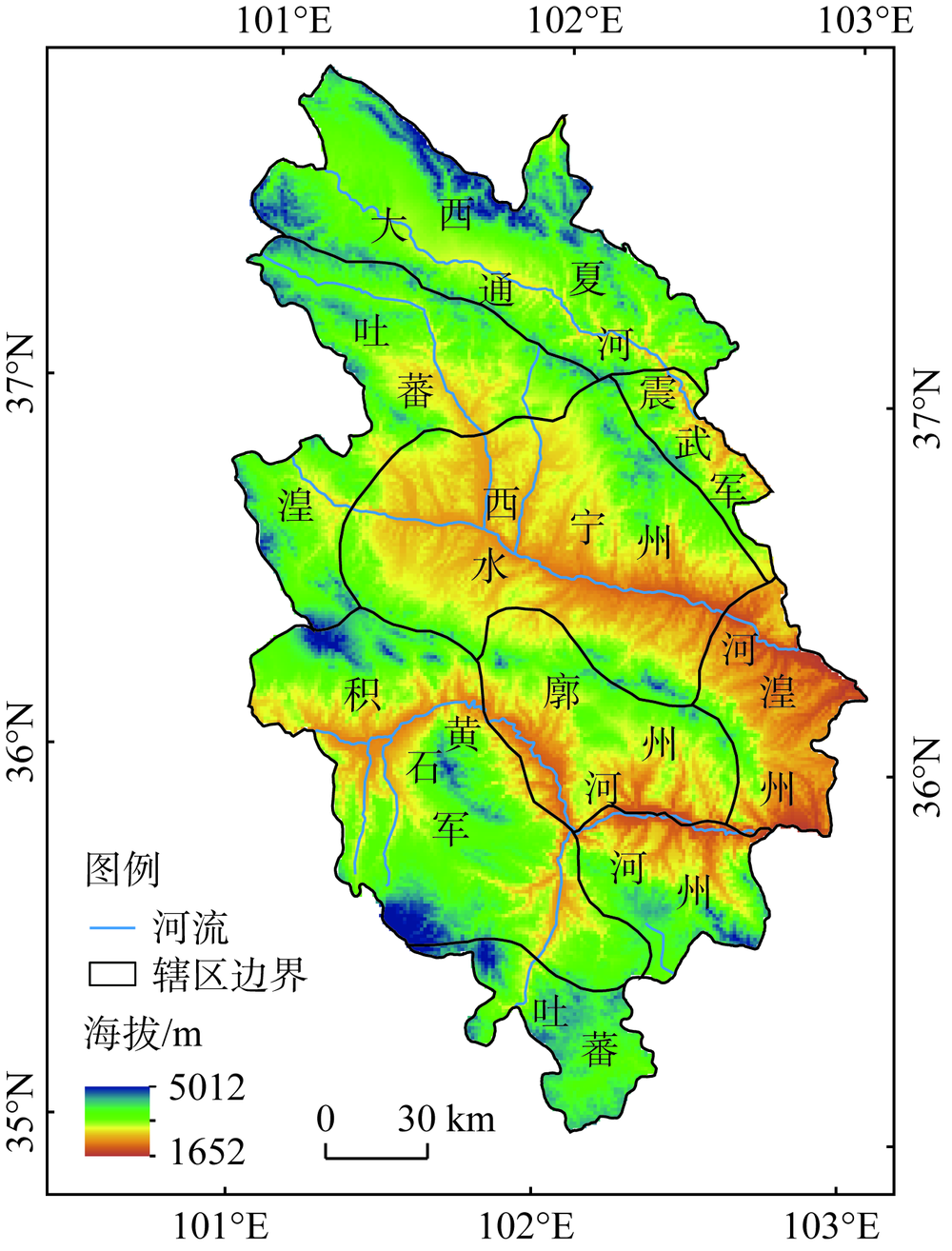
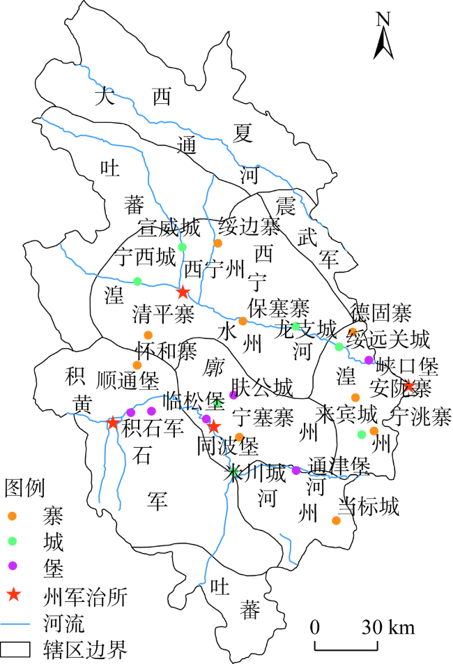
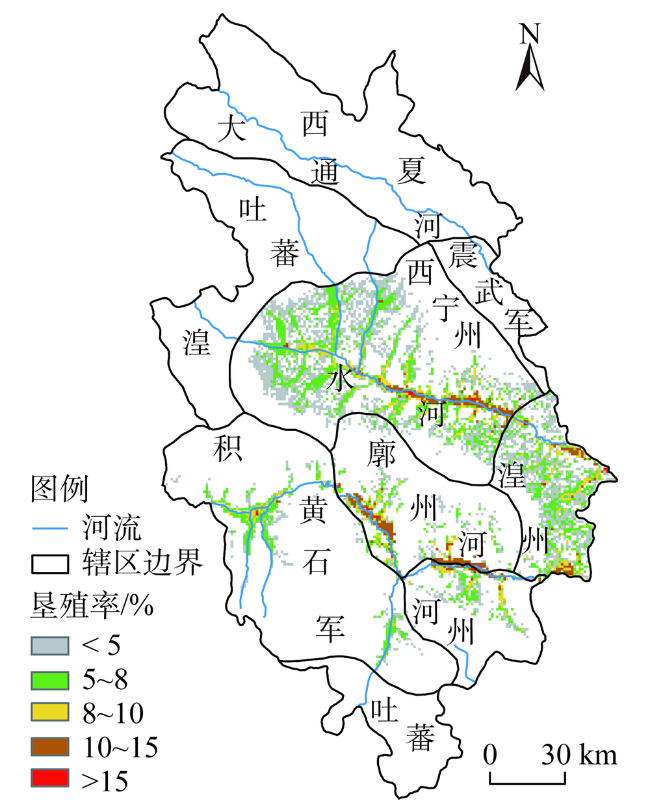
The Hehuang Valley in the upper reaches of the Yellow River is one of the areas with a long history of human activities, and it is the westernmost part of cultivated land reclamation along the Yellow River. The reconstruction of settlements and cultivated land has practical significance for the study of human activities and global change in this basin. In this paper, a database of settlements and cultivated land in the Hehuang Valley in the late Northern Song Dynasty (1117) was established by combing a large number of historical documents. Based on the spatial distribution of settlements, the grid model was used to reconstruct the cultivated land pattern of the study area with an accuracy of 1 km×1 km. The results show that: (1) The settlements in the Hehuang Valley in the upper reaches of the Yellow River in the late Northern Song Dynasty are concentrated in alluvial and proluvial plains along the main stream of the Yellow River and Huangshui River with relatively low altitude and gentle slope, and the "City" is mainly distributed in the mountain pass in the relatively low altitude area, highlighting its defense function; "States and Castles" are mostly distributed along rivers with relatively flat terrain and relatively geo-safe; however, "Villages" are scattered along the tributaries of rivers, showing the characteristics of disorderly development. (2) The total cultivated land area in the Hehuang Valley is estimated to be about 304.67 km2, with only 16.16% of the grids distributed with cultivated land and only 24.16% of the grids with the highest reclamation rate, among which 74.06% are distributed in the Huangshui Valley and 25.94% along the main stream of the Yellow River, indicating that cultivated land reclamation in the late Northern Song Dynasty is mainly concentrated in the Huangshui River Basin. (3) From the altitude of settlement distribution, 78.09% of the cultivated land grids are distributed in the area of flat terrain with water below 2600 m above sea level, and 21.91% of the grids are distributed in the shallow mountains between 2600 m and 3200 m, indicating that the cultivated land range was not large at that time, and the altitude greatly restricted the expansion of cultivated land, which was mainly distributed in areas with superior irrigation conditions. (4) Rebuilding the spatial pattern of cultivated land based on settlement accords with the fact that cultivated land is distributed with settlements, which is more reliable.
GUO Rong , LIU Feng-gui , CHEN Qiong , ZHOU Qiang , GU Xi-jing , CAI Xiang-cuo-mao . Reconstruction of cultivated land pattern in the upper reaches of the Yellow River in the late Northern Song Dynasty:Take Hehuang Valley as an example[J]. JOURNAL OF NATURAL RESOURCES, 2021 , 36(1) : 27 -36 . DOI: 10.31497/zrzyxb.20210102
表1 聚落地名库数据结构Table 1 Data structure of settlement toponym database |
| 聚落名称 | 建立时间 | 位置描述 | 聚落类型 | 所属行政区域 | 现代地名 | 经度 | 纬度 |
|---|---|---|---|---|---|---|---|
| 西宁州 | 崇宁三年 (1104年) | 东至保塞寨五十七里,西至宁西城四十里,南至清平寨五十里,北至宣威城五十里 | 州军 治所 | 西宁州 | 西宁市 | 101°46′42″ | 36°37′24″ |
| 龙支城 | 崇宁三年 (1104年) | 东至德固寨一十八里,西至保塞寨药邦硖二十二里,南至廓州 | 城 | 西宁州 | 乐都区碾 伯镇 | 102°23′46″ | 36°29′27″ |
| 清平寨 | 崇宁三年 (1104年) | 东至廓州绥平堡界三十五里,西至赤岭铁堠子,南至怀和寨界二十五里,北至西宁州二十五里 | 寨 | 西宁州 | 湟中区上新庄村 | 101°36′6″ | 36°25′37″ |
| … | … | … | … | … | … | … | |
| 同波堡 | 崇宁三年 (1104年) | 东至廓州巡检界二十里,西至肤公城界一十五里,南至黄河不及里,北至肤公城一十五里 | 堡 | 廓州 | 化隆县下多巴一村 | 101°55′53″ | 36°4′20″ |
| … | … | … | … | … | … | … |
表2 北宋后期河湟谷地各行政区域耕地面积数据Table 2 The statistics of cultivated land area in each administrative area of Hehuang Valley in late Northern Song Dynasty |
| 北宋后期河湟谷地 行政区域名称 | 耕地所占 比例/% | 折算耕地 面积/km2 |
|---|---|---|
| 西宁州 | 48.98 | 149.23 |
| 湟州 | 21.43 | 65.29 |
| 廓州 | 13.24 | 40.39 |
| 河州 | 9.84 | 29.98 |
| 积石军 | 6.51 | 19.78 |
| 合计 | 100.00 | 304.67 |
| [1] |
|
| [2] |
|
| [3] |
|
| [4] |
|
| [5] |
吴立钰. 气候变化和人类活动对伊逊河流域径流变化的影响. 自然资源学报, 2020,35(7):1744-1756.
[
|
| [6] |
|
| [7] |
|
| [8] |
|
| [9] |
李秀彬. 全球环境变化研究的核心领域: 土地利用/土地覆被变化的国际研究动向. 地理学报, 1996,50(6):553-558.
[
|
| [10] |
|
| [11] |
|
| [12] |
|
| [13] |
|
| [14] |
|
| [15] |
|
| [16] |
|
| [17] |
|
| [18] |
|
| [19] |
|
| [20] |
|
| [21] |
|
| [22] |
|
| [23] |
|
| [24] |
|
| [25] |
冯永恒, 张时煌, 何凡能, 等. 20世纪中国耕地格网化数据分区重建. 地理科学进展, 2014,33(11):1546-1555.
[
|
| [26] |
|
| [27] |
王宇坤, 陶娟平, 刘峰贵. 西藏雅鲁藏布江中游河谷地区1830年耕地格局重建. 地理研究, 2015,34(12):2355-2367.
[
|
| [28] |
李美娇, 何凡能, 杨帆. 明代省域耕地数量重建及时空特征分析. 地理研究, 2020,39(2):447-460.
[
|
| [29] |
罗静, 张镱锂, 刘峰贵, 等. 青藏高原东北部河湟谷地1726年耕地格局重建. 地理研究, 2014,33(7):1285-1296.
[
|
| [30] |
李俊, 叶瑜, 魏学琼. 过去300 a大清河上游南部流域耕地变化重建. 地理科学进展, 2019,38(6):883-895.
[
|
| [31] |
吴致蕾, 刘峰贵, 陈琼, 等. 公元733年河湟谷地耕地分布格局重建. 资源科学, 2017,39(2):252-262.
[
|
| [32] |
牛奥运. 河湟谷地史前聚落分布与耕地格局演变. 泉州: 华侨大学, 2018.
[
|
| [33] |
陈强强, 刘峰贵, 方修琦, 等. 新石器时代晚期华北地区耕地重建. 地理研究, 2019,38(12):2927-2940.
[
|
| [34] |
何凡能, 李士成, 张学珍. 北宋中期耕地面积及其空间分布格局重建. 地理学报, 2011,66(11):1531-1539.
[
|
| [35] |
连丽聪. 民国中期湖南洞庭湖区耕地空间格局重建. 地球信息科学, 2020,22(5):989-996.
[
|
| [36] |
谢端琚. 甘青地区史前考古. 北京: 文物出版社, 2002.
[
|
| [37] |
[
|
| [38] |
赵衍君. 明代河湟谷地聚落格局演变与耕地变化. 西宁: 青海师范大学, 2016.
[
|
| [39] |
罗静, 陈琼, 刘峰贵, 等. 青藏高原河谷地区历史时期耕地格局重建方法探讨: 以河湟谷地为例. 地理科学进展, 2015,34(2):207-216.
[
|
| [40] |
罗静. 青藏高原河谷地区历史时期耕地格局重建: 以清代河湟谷地为例. 西宁: 青海师范大学, 2015.
[
|
| [41] |
李士成, 张镱锂, 何凡能. 过去百年青海和西藏耕地空间格局重建及其时空变化. 地理科学进展, 2015,34(2):197-206.
[
|
| [42] |
杨保. 青藏高原地区过去2000年来的气候变化. 地球科学进展, 2003,18(2):285-291.
[
|
| [43] |
方修琦, 叶瑜, 张成鹏, 等. 中国历史耕地变化及其对自然环境的影响. 古地理学报, 2019,21(1):160-174.
[
|
| [44] |
崔永红. 北宋河湟地区招刺弓箭手垦田戍守的措施及意义. 青海社会科学, 1993, (3):74-80.
[
|
| [45] |
脱脱. 宋史:卷三百五十七: 何灌传. 吉林: 吉林人民出版社, 1998: 11226.
[
|
| [46] |
脱脱. 宋史: 卷八七: 地理志. 吉林: 吉林人民出版社, 1998: 1372-1391.
[
|
| [47] |
徐松辑, 刘琳, 等. 宋会要辑稿: 方域二十. 上海: 上海古籍出版社, 2014: 9681-9683.
[
|
| [48] |
谭其骧. 中国历史地图集—宋辽金时期. 北京: 中国地图出版社, 1996: 20-21.
[
|
| [49] |
周宏伟. 北宋河湟地区城堡寨关位置通考. 中国历史地理论丛, 1992, (2):173-199.
[
|
| [50] |
张生寅. 北宋震武军城位置考辨: 兼谈门源县境内几座古城的始筑年代. 青海社会科学, 2009,175(1):102-106.
[
|
| [51] |
赵瞳. 北宋农业研究. 郑州: 郑州大学, 2017.
[
|
| [52] |
韩剑尘, 赵威. 古代农业土地面积单位生成与发展的驱动力研究: 以“亩”为中心. 自然辩证法研究, 2017,33(6):63-68.
[
|
| [53] |
黄以周. 续资治通鉴长编拾补: 卷21. 北京: 中华书局, 2004.
[
|
| [54] |
连菊霞. 北宋经制西北民族对生态环境造成的影响. 敦煌学辑刊, 1999, (2):92-100.
[
|
| [55] |
郑景云, 邵雪梅, 郝志新, 等. 过去2000年中国气候变化研究. 地理研究, 2010,29(9):1561-1570.
[
|
| [56] |
方修琦, 叶瑜, 葛全胜. 从城镇体系的演变看清代东北地区的土地开发. 地理科学, 2005,25(2):129-134.
[
|
| [57] |
吕妍, 张树文, 杨久春. 基于地名志的东北历史时期土地利用变化研究: 以吉林省镇赉县为例. 地球信息科学学报, 2010,12(2):2174-2179.
[
|
| [58] |
|
| [59] |
韩茂莉, 张一, 方晨. 全新世以来西辽河流域聚落环境选择与人地关系. 地理研究, 2008,27(5):1118-1128, 1225.
[
|
/
| 〈 |
|
〉 |
