
JOURNAL OF NATURAL RESOURCES >
Spatiotemporal patterns of precipitation and drought and flood using Z-index in Democratic People's Republic of Korea
Received date: 2019-12-11
Request revised date: 2020-05-22
Online published: 2020-12-18
Copyright
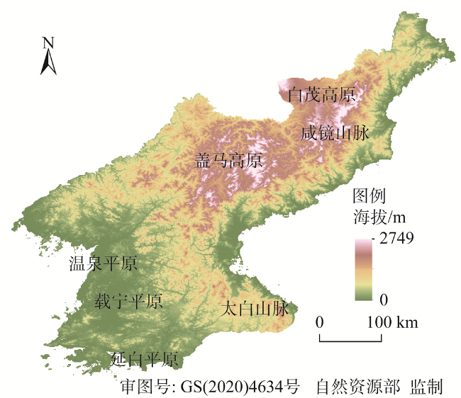
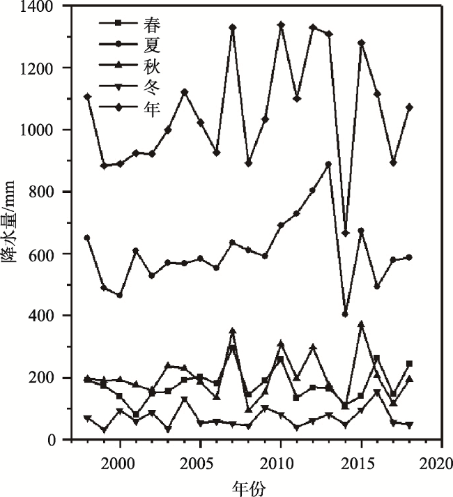
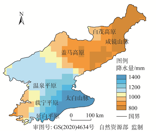
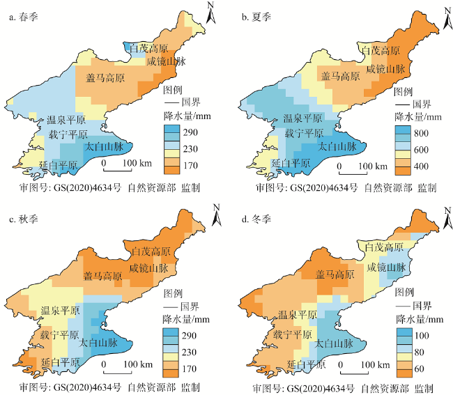
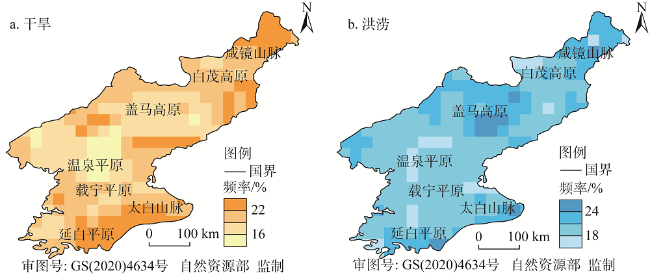
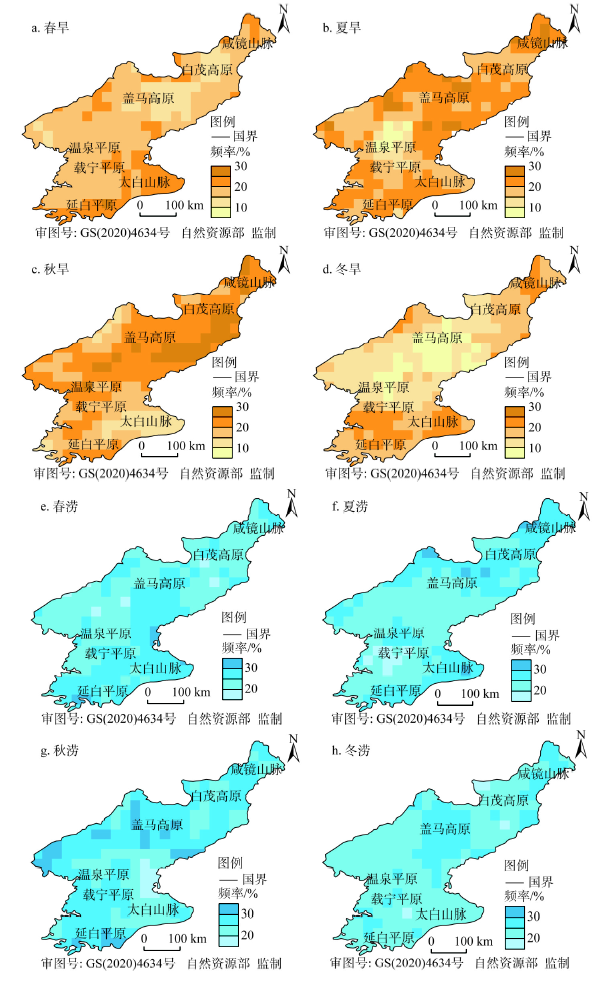
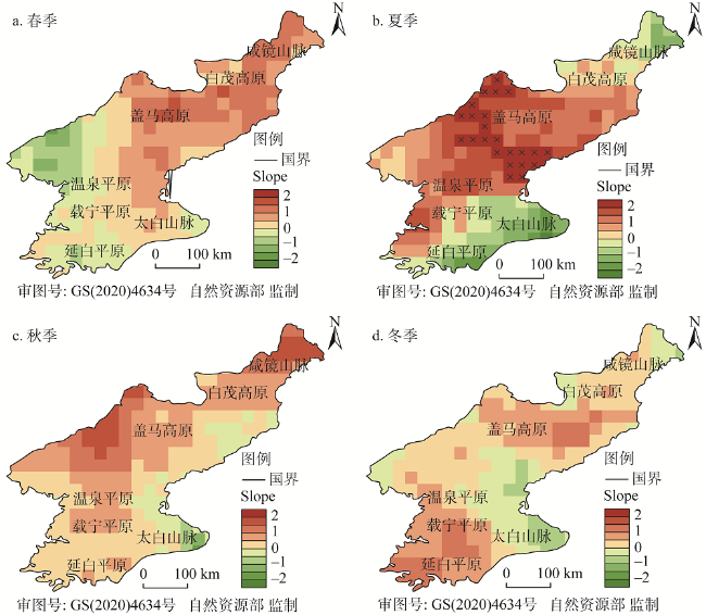
Drought and flood are the main agrometeorological disasters in the Democratic People's Republic of Korea (DPRK), which have great influences on the growth of the crops and directly affect grain yield. The level of agricultural production is low because of insufficient investment and poor irrigation installation. Drought and flood are prone to a reduction in grain yield in DPRK. The food security issue in DPRK is not only related to this country's domestic stability but also related to the geo-security in Northeast Asia. Therefore, understanding the spatial and temporal patterns of drought and flood is very important for preventing disasters in this country. In this study, the Tropical Rainfall Measuring Mission (TRMM) 3B43 time series dataset was used to reveal the spatial and temporal patterns of drought and flood in DPRK from 1998 to 2018. The drought and flood levels were developed by a Z-index. In addition, the trend of Z-index is tested by the Mann-Kendall (M-K) method. The result shows that the precipitation in the study area has an obvious seasonal pattern, with more than 57.29% of the rainfall concentrated in summer, and only 6.90% in winter. The precipitation in spring is slightly higher than that in autumn. Both interannual and seasonal precipitation show increasing trends during the study period. The spatial pattern of precipitation increases from the northeast to the southeast along the coastline. Generally, the regional comprehensive drought and flood levels in DPRK are normal at the national scale. Moderate drought and flood levels occur most frequently, followed by severe drought and flood, and the frequency of extreme drought and flood eventd is the lowest. The floods frequently occur in autumn, and droughts frequently occur in summer and winter. The frequency of drought and flood events appear in the north of DPRK, particularly in Hamgyeong Mountains and the Gaema Plateau. Flood intensity shows an increasing trend in spring, summer, and autumn, while drought and flood level tended to be normal in winter. The central and northern regions passed the significance of 95%. It is expected that the trend of drought and flood in DPRK will be consistent in future. The results of the study provide a unique insight for understanding the agricultural production in DPRK.
FEI Long , DENG Guo-rong , ZHANG Hong-yan , GUO Xiao-yi , WANG Xiao-dong . Spatiotemporal patterns of precipitation and drought and flood using Z-index in Democratic People's Republic of Korea[J]. JOURNAL OF NATURAL RESOURCES, 2020 , 35(12) : 3051 -3065 . DOI: 10.31497/zrzyxb.20201219
表1 降水Z指数旱涝等级划分标准Table 1 Classification of drought-flood criterion for Z index |
| 等级 | 降水Z指数 | 区域旱涝综合Z' 指数 | 类型 |
|---|---|---|---|
| 1 | Z >1.645 | Z' ≥75 | 极涝 |
| 2 | 1.037<Z≤ 1.645 | 50≤Z'<75 | 大涝 |
| 3 | 0.842<Z≤ 1.037 | 25≤Z'<50 | 偏涝 |
| 4 | -0.842<Z≤ 0.842 | -25<Z'<25 | 正常 |
| 5 | -1.037<Z≤ -0.842 | -50<Z'≤-25 | 偏旱 |
| 6 | -1.645<Z≤ -1.037 | -75<Z'≤-50 | 大旱 |
| 7 | Z≤-1.645 | Z'≤-75 | 极旱 |
图6 朝鲜旱涝发生频率的空间分布Fig. 6 Spatial patterns of frequency of drought and flood during 1998 to 2018 in DPRK |
表2 朝鲜旱涝年份统计Table 2 The statistics of drought and flood in North Korea (年) |
| 极涝 | 大涝 | 偏涝 | 偏旱 | 大旱 | 极旱 | |
|---|---|---|---|---|---|---|
| 年际 | 2001、2016、2018、2008 | 2010、2012、2014、2015 | ||||
| 春季 | 2010、2007 | 2018、2004 | 2011 | 2014、2016 | 2001 | |
| 夏季 | 2009、2012、2010 | 2014、2017、1999、2016 | 2000 | |||
| 秋季 | 2015 | 2007 | 2012、2011、2010 | 2014 | 2008 | 2000 |
| 冬季 | 2016 | 2004 | 2009、2015、2018 | 1999、2011、2005、2003 | 2008 |
| [1] |
|
| [2] |
田苗, 李卫国. 基于TRMM遥感数据的旱涝时空特征分析. 农业机械学报, 2015,46(5):252-257.
[
|
| [3] |
毕硕本, 孙力, 李兴宇. 基于EEMD的1470—1911年黄河中下游地区旱涝灾害多时间尺度特征分析. 自然灾害学报, 2018, (1):137-147.
[
|
| [4] |
李双双, 杨赛霓, 刘宪锋. 1960—2013年北京旱涝变化特征及其影响因素分析. 自然资源学报, 2015,30(6):951-962.
[
|
| [5] |
杜华明, 延军平, 杨登兴, 等. 嘉陵江流域降水变化及旱涝多时间尺度分析. 自然资源学报, 2015,30(5):836-845.
[
|
| [6] |
李卫国. 作物旱涝灾情遥感监测进展与思考. 江苏农业学报, 2013,29(6):1503-1506.
[
|
| [7] |
|
| [8] |
|
| [9] |
孙美平, 张海瑜, 巩宁刚, 等. 基于TRMM降水订正数据的祁连山地区最大降水高度带研究. 自然资源学报, 2019,34(3):646-657.
[
|
| [10] |
|
| [11] |
|
| [12] |
武文博, 游庆龙, 王岱. 基于均一化降水资料的中国极端降水特征分析. 自然资源学报, 2016,31(6):1015-1026.
[
|
| [13] |
|
| [14] |
王志伟, 翟盘茂. 中国北方近50年干旱变化特征. 地理学报, 2003,58(s1):61-68.
[
|
| [15] |
李红军, 江志红, 魏文寿. 近40年来塔里木河流域旱涝的气候变化. 地理科学, 2007,27(6):801-807.
[
|
| [16] |
邢子强, 严登华, 鲁帆, 等. 人类活动对流域旱涝事件影响研究进展. 自然资源学报, 2013,28(6):1070-1082.
[
|
| [17] |
何艳虎, 陈晓宏, 林凯荣. 东江流域近50年旱涝时空演变特征. 地理科学, 2014,34(11):1391-1398.
[
|
| [18] |
彭世球, 刘段灵, 孙照渤. 区域海气耦合模式研究进展. 中国科学: 地球科学, 2012,27(9):1301-1316.
[
|
| [19] |
景丞, 王艳君, 姜彤. CMIP5多模式对朝鲜干旱模拟与预估. 干旱区资源与环境, 2016,30(12):95-102.
[
|
| [20] |
杜灵通, 田庆久, 黄彦, 等. 基于TRMM数据的山东省干旱监测及其可靠性检验. 农业工程学报, 2012,28(2):121-126.
[
|
| [21] |
王蕾. 朝鲜农作物遥感估产及粮食生产潜力评价. 长春: 东北师范大学, 2012.
[
|
| [22] |
刘小婵, 赵建军, 张洪岩, 等. TRMM降水数据在东北地区的精度验证与应用. 自然资源学报, 2015,30(6):1047-1056.
[
|
| [23] |
蔡研聪, 金昌杰, 王安志, 等. 中高纬度地区TRMM卫星降雨数据的精度评价. 应用生态学报, 2014,25(11):3296-3306.
[
|
| [24] |
李景刚, 李纪人, 黄诗峰. 基于TRMM数据和区域综合Z指数的洞庭湖流域近10年旱涝特征分析. 资源科学, 2010,32(6):1103-1110.
[
|
| [25] |
何萍, 白洪强, 李矜霄. 基于Z指数的昆明市洪涝研究. 地球与环境, 2015,43(1):71-79.
[
|
| [26] |
袁媛, 王心源, 雷能忠. 基于GIS的江淮分水岭地区旱涝灾害时空分析. 水文, 2007,27(6):36-38.
[
|
| [27] |
鞠笑生, 杨贤为, 陈丽娟. 我国单站旱涝指标确定和区域旱涝级别划分的研究. 应用气象学报, 1997,8(1):26-33.
[
|
| [28] |
|
| [29] |
|
| [30] |
李运刚, 何娇楠, 李雪. 基于SPEI和SDI指数的云南红河流域气象水文干旱演变分析. 地理科学进展, 2016,35(6):758-767.
[
|
| [31] |
戚德康, 南颖, 孙博杨, 等. 2000年以来朝鲜植被覆盖变化及其与气候因子的相关性研究. 干旱区地理, 2017,40(4):839-849.
[
|
/
| 〈 |
|
〉 |