
JOURNAL OF NATURAL RESOURCES >
Spatio-temporal characteristics of non-point source and sewer overflow pollution and its impacts on water environment in Shenzhen Bay Basin
Received date: 2019-05-14
Request revised date: 2019-10-10
Online published: 2020-12-18
Copyright
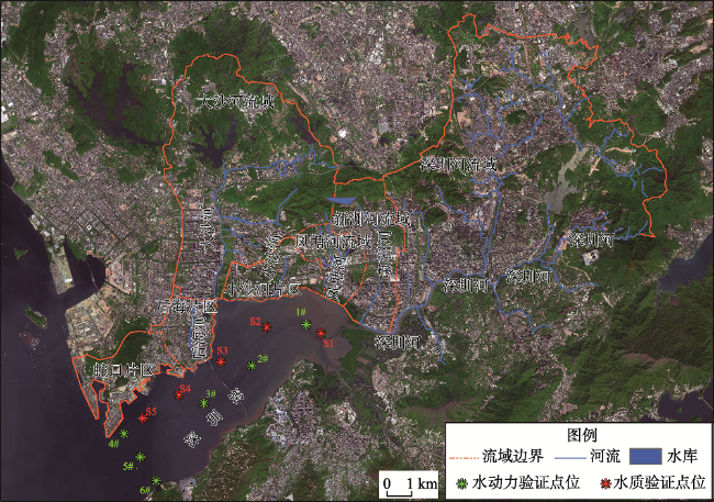
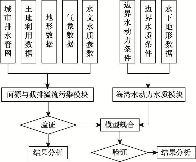
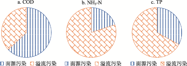
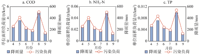
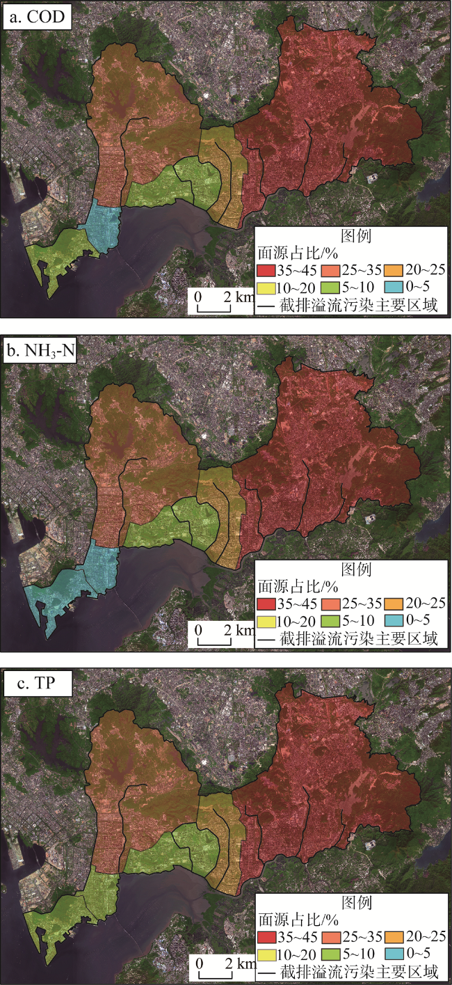
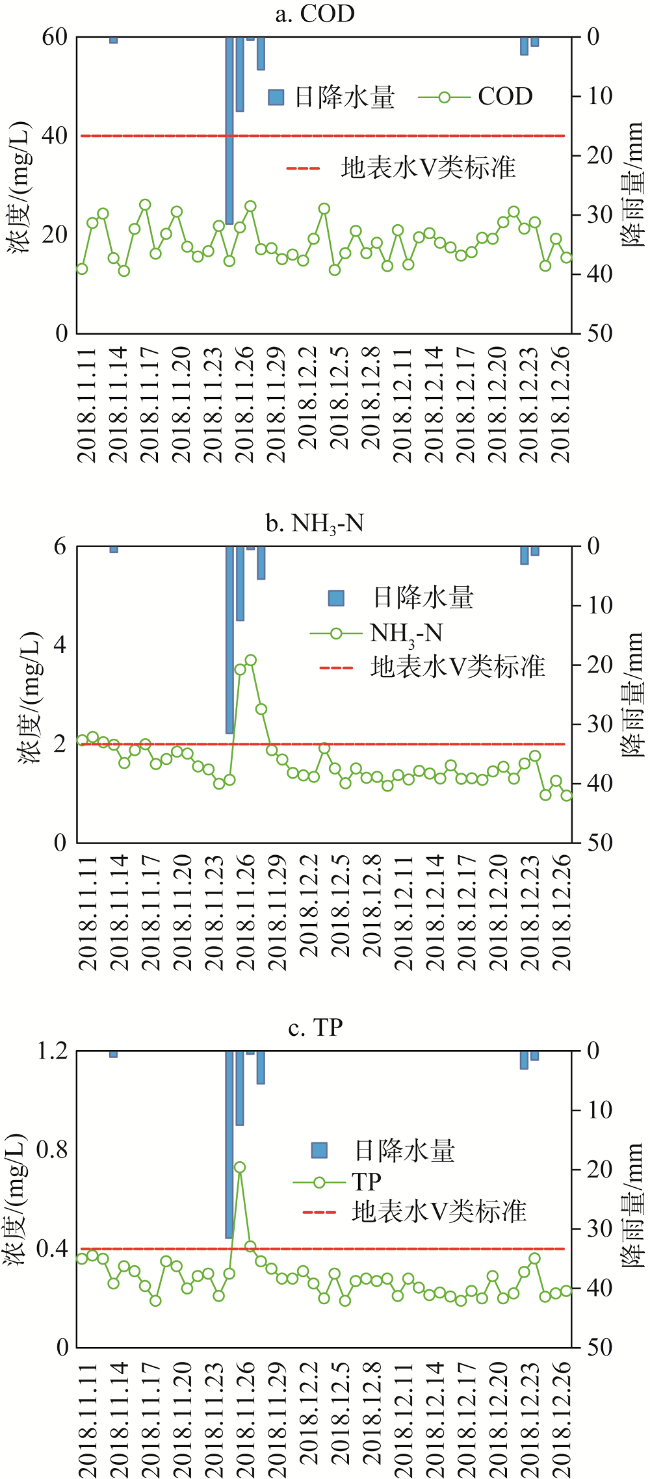
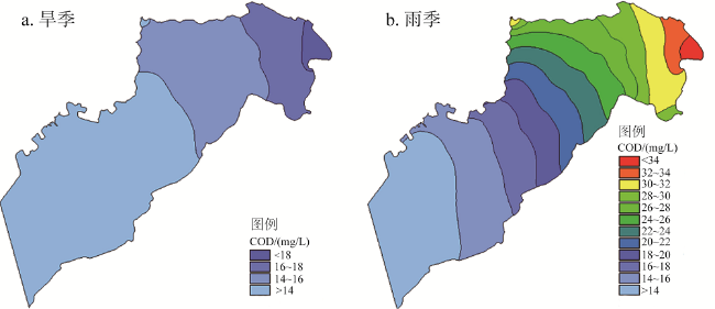
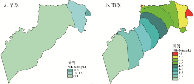
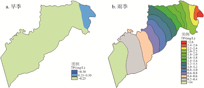
With the effective control of point source pollution, non-point source and sewer overflow pollution becomes the main type of water pollution. Based on materials of land use, urban drainage network and so on, the basin-bay integrated water environmental model was established, and the spatio-temporal characteristics of non-point source and sewer overflow pollution in Shenzhen Bay Basin as well as its impacts on water environment were analyzed. Results showed that (1) The non-point source and sewer overflow pollution loading per unit area of COD, NH3-N and TP in rainy season was 17.21 t/km2and 10.21 t/km2, 0.17 t/km2and 0.69 t/km2, 0.04 t/km2 and 0.07 t/km2, respectively; (2) The non-point source and sewer overflow pollution was concentrated in May and August with more heavy rainfall observed in Shenzhen River Basin, Dasha River Basin and Xinzhou River Basin with larger area, steeper surface slope and more sewerage cutting projects; (3) The COD, NH3-N and TP concentrations of non-point source and sewer overflow pollution could approach 3.7, 18.2 and 8.5 times the values of water quality standards, respectively; (4) The areas where the COD, NH3-N and TP concentrations in rainy season were higher than those in dry season exceeded 40%, 60% and 65% of the total area of Shenzhen Bay, respectively.
LUO Huan , CHEN Xiu-hong , WU Qiong , LUO Na , HUANG Xu . Spatio-temporal characteristics of non-point source and sewer overflow pollution and its impacts on water environment in Shenzhen Bay Basin[J]. JOURNAL OF NATURAL RESOURCES, 2020 , 35(12) : 3018 -3028 . DOI: 10.31497/zrzyxb.20201216
表1 面源与截排溢流污染模块主要参数Table 1 Main parameters of SWMM |
| 用地类型 | 污染物最大累积量 (COD/NH3-N/TP) | 半饱和累积时间 (COD/NH3-N/TP) | 冲刷系数 (COD/NH3-N/TP) | 冲刷指数 (COD/NH3-N/TP) |
|---|---|---|---|---|
| 建设用地 | 5.715/0.32/0.3 | 0.4/0.4/0.4 | 2.639/0.27/0.01 | 0.102/1.13/1.6 |
| 绿地 | 0.187/0.22/0.3 | 0.4/0.4/0.4 | 0.015/0.12/0.006 | 1.2/1.13/1.2 |
表2 流域—海湾一体化水环境模型水动力与水质验证误差统计表Table 2 Validation of hydrodynamics and quality (%) |
| 水动力验证点位 | 流速误差 | 水质验证点位 | COD误差 | NH3-N误差 | TP误差 |
|---|---|---|---|---|---|
| 1# | -10.63 | S1 | -11 | -11 | 7 |
| 2# | 11.30 | S2 | 9 | 19 | -18 |
| 3# | 7.92 | S3 | 6 | 12 | -17 |
| 4# | 4.48 | S4 | -12 | -17 | -15 |
| 5# | 8.45 | S5 | 8 | 14 | -15 |
| 6# | 5.18 | — | — | — | — |
表3 深圳河流域“11.25”暴雨溢流情况统计表Table 3 Sewer overflow of rainstorm of “11.25” in Shenzhen River Basin |
| 溢流断面 | 发生时间/(月.日) | 水质指标/(mg/L) | ||
|---|---|---|---|---|
| COD | NH3-N | TP | ||
| 皇岗河河口 | 11.26 | 108* | 13.83* | 1.74* |
| 沙湾河沿河箱涵出水口 | 11.25 | 38.3 | 16.04* | 1.80* |
| 11.26 | 75.9* | 13.67* | 3.01* | |
| 11.27 | 109* | 22.36* | 2.8* | |
| 11.28 | 95.9* | 3.73* | 0.63* | |
| 沙湾河截排隧洞溢流口 | 11.26 | 26.9 | 4.16* | 1.96* |
| 11.28 | — | 4.37* | 0.94* | |
| 莲花水沿河箱涵溢流口 | 11.26 | 21.5 | 1.81 | 1.39* |
| 11.27 | 12.8 | 1.58 | 0.65* | |
| 11.28 | 14.2 | 1.04 | 0.69* | |
| 李朗河下游总口前 | 11.25 | 148.5* | 36.32* | 3.41* |
| 11.26 | 45.1* | 8.23* | 2.01* | |
| 白泥坑沟河口 | 11.26 | 45.7* | 6.11* | 2.25* |
注:*表示水质浓度超过地表水V类标准。 |
图7 深圳湾旱季和雨季COD浓度包络范围Fig. 7 Concentration envelope lines of COD over Shenzhen Bay in rainy and dry seasons |
图8 旱季和雨季深圳湾NH3-N浓度包络范围Fig. 8 Concentration envelope lines of NH3-N in Shenzhen Bay in rainy and dry seasons |
| [1] |
荆延德, 张华美. 基于LUCC的南四湖流域面源污染输出风险评估. 自然资源学报, 2019,34(1):128-139.
[
|
| [2] |
丁程程, 刘健. 中国城市面源污染现状及其影响因素. 中国人口·资源与环境, 2011,21(s1):86-89.
[
|
| [3] |
房金秀, 谢文霞, 朱玉玺, 等. 合流制面源污染传输过程与污染源解析. 环境科学, 2019, (6):1-13.
[
|
| [4] |
贺文彦, 谢文霞, 赵敏华, 等. 海绵城市试点区域内面源污染发生过程及其对水体污染负荷贡献评估. 环境科学学报, 2018,38(4):1586-1597.
[
|
| [5] |
|
| [6] |
|
| [7] |
|
| [8] |
|
| [9] |
|
| [10] |
|
| [11] |
李贺, 李田. 上海高密度居民区合流制系统雨天溢流水质研究. 环境科学, 2006, (8):1565-1569.
[
|
| [12] |
刘昌明, 张永勇, 王中根, 等. 维护良性水循环的城镇化LID模式: 海绵城市规划方法与技术初步探讨. 自然资源学报, 2016,31(5):719-731.
[
|
| [13] |
李思远, 管运涛, 陈俊, 等. 苏南地区合流制管网溢流污水水质特征分析. 给水排水, 2015,51(s1):344-348.
[
|
| [14] |
|
| [15] |
赖后伟, 黎京士, 庞志华, 等. 深圳大工业区初期雨水水质污染特征研究. 环境污染与防治, 2016,38(3):11-15.
[
|
| [16] |
唐俊逸, 陈海龙, 陈芸, 等. 深圳西部海域陆源入海污染物及外来污染状况分析. 环境科学导刊, 2018,37(6):80-85.
[
|
| [17] |
郑明凤, 陈斯典, 秦华鹏, 等. 降雨径流污染对深圳湾富营养化影响的模拟研究. 中国给水排水, 2017,33(9):133-138.
[
|
| [18] |
吴建立, 孙飞云, 董文艺, 等. 基于SWMM模拟的城市内河区域雨水径流和水质分析. 水利水电技术, 2012,43(8):90-94.
[
|
| [19] |
方神光, 陈文龙, 崔丽琴. 伶仃洋河口水域纳潮特性分析. 海洋科学, 2012,36(6):105-112.
[
|
| [20] |
黄硕, 郭青海. 城市景观格局演变的水环境效应研究综述. 生态学报, 2014,34(12):3142-3150.
[
|
| [21] |
|
| [22] |
荆红卫, 张志刚, 郭婧. 北京北运河水系水质污染特征及污染来源分析. 中国环境科学, 2013,33(2):319-327.
[
|
| [23] |
李海燕, 徐尚玲, 黄延, 等. 合流制排水管道雨季出流污染负荷研究. 环境科学学报, 2013,33(9):2522-2530.
[
|
| [24] |
郝利霞, 孙然好, 陈利顶. 海河流域河流生态系统健康评价. 环境科学, 2014,35(10):3692-3701.
[
|
| [25] |
陈洁, 朱广伟, 许海, 等. 不同雨强对太湖河网区河道入湖营养盐负荷影响. 环境科学, https: //doi.org/10.13227/j.hjkx.201905103.
[
|
| [26] |
|
| [27] |
张招招, 程军蕊, 毕军鹏, 等. 甬江流域土地利用方式对面源磷污染的影响: 基于SWAT模型研究. 农业环境科学学报, 2019,38(3):650-658.
[
|
| [28] |
杨斌, 钟秋平, 张晨晓, 等. 钦州湾叶绿素a和初级生产力时空变化及其影响因素. 环境科学学报, 2015,35(5):1333-1340.
[
|
| [29] |
|
/
| 〈 |
|
〉 |