
JOURNAL OF NATURAL RESOURCES >
"Double evaluations" of karst area from the perspective of ecological civilization: A case study of Ningyuan in ecologically sensitive area
Received date: 2020-02-05
Request revised date: 2020-04-23
Online published: 2020-12-28
Copyright
The purpose of this paper is to simplify the "double evaluations" mechanism and evaluation process, build an index system with karst characteristics from the perspective of ecological civilization to identify the advantages and disadvantages of the local resource background, and depict the characteristics of the spatial pattern more accurately. The evaluation index system was constructed from three perspectives including ecology, agriculture and construction. And we integrated the "barrel short board effect", weighted linear summation and multi-factor spatial overlap analysis to calculate the suitability degree of different functions in Ningyuan. The results show that the importance of ecological protection in the study area is relatively high, and the characteristics of spatial agglomeration and differentiation are obvious. The suitability of agricultural production is generally low. The areas suitable for production mainly take the central dividing line of the city as the axis belt, which shows a symmetrical distribution pattern on the east and west sides. On the whole, the suitability of construction and development is low, and the distribution pattern is remarkable. The pattern of land development and protection of "three-ring belts radiating" is obvious, and the construction-agriculture-ecological space is distributed in concentric circles. Areas of multiple, double, single and inappropriate spaces are 36672.67 hm2, 32276.11 hm2, 181022 hm2 and 175.46 hm2, accounting for 14.66%, 12.90%, 72.37% and 0.07%, respectively. The conclusion is that Ningyuan has good natural conditions, but it still needs to strengthen the protection of ecological space in the south and north to meet the requirements of ecological civilization construction. There are some conflicts between agricultural production and ecological protection space, so it is necessary to rationally optimize the structure and distribution of agricultural production to ensure the "double security" of regional food and ecology. There is less space suitable for construction and development, so we need to use land resources intensively, adjust and change the mode of development properly, and coordinate the relationship between "three living spaces". Double- and multi-suitable land for ecological construction is the key goal of the future development and protection pattern. This will give us a better understanding of the base of land space, and improve the scientificity and operability, which can provide reference and scientific support for the "double evaluations" work in ecologically fragile and sensitive areas, such as Southwest China.
LI Long , WU Da-fang , LIU Yan-yan , TENG Li , WU Zhi-feng , FENG Zhao-hua . "Double evaluations" of karst area from the perspective of ecological civilization: A case study of Ningyuan in ecologically sensitive area[J]. JOURNAL OF NATURAL RESOURCES, 2020 , 35(10) : 2385 -2400 . DOI: 10.31497/zrzyxb.20201007
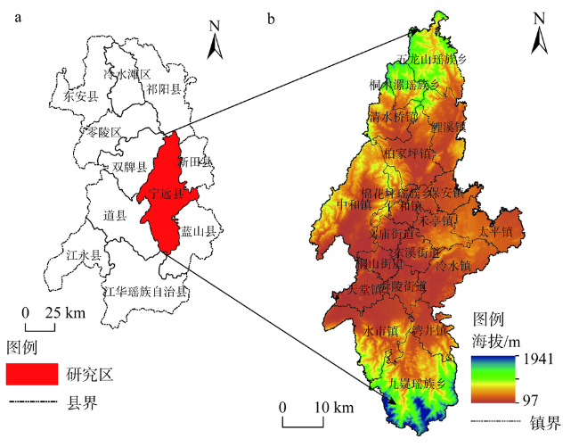
Fig. 1 The study area图1 研究区域 |
Fig. 2 Evaluation technical route图2 评价技术路线 |
Table 1 Evaluation index system of ecological protection importance表1 生态保护重要性评价指标体系 |
| 目标层 | 准则层 | 要素层 |
|---|---|---|
| 生态保护 重要性 | 生态重要性 | 保护物种分布区(x1) |
| 生物多样性优先保护区(x2) | ||
| 水源保护地(x3) | ||
| 水系缓冲区(x4) | ||
| 自然保护区(x5) | ||
| 湿地公园(x6) | ||
| 森林公园(x7) | ||
| 水土流失敏感性 | 降雨侵蚀力(x8) | |
| 土壤质地(x9) | ||
| 地形起伏度(x10) | ||
| 植被覆盖度(x11) | ||
| 石漠化敏感性 | 地形坡度(x12) | |
| 碳酸盐岩露出面积百分比(x13) | ||
| 植被覆盖度(x11) |
Table 2 Evaluation index system of agricultural production suitability表2 农业生产适宜性评价指标体系 |
| 目标层 | 准则层 | 要素层 | 权重 |
|---|---|---|---|
| 农业生产 适宜性 | 禁止性承 载力指标 | 风景名胜区(i1) | — |
| 历史文化街区(i2) | — | ||
| 农业文化遗产(i3) | — | ||
| 生态保护重要性(i4) | — | ||
| 水域(i5) | — | ||
| 洪水位线(i6) | — | ||
| 坡度(i7) | — | ||
| 土层厚度(i8) | — | ||
| 农业适宜 性指标 | 生态保护重要性(j1) | 0.1125 | |
| 坡度(j2) | 0.0872 | ||
| 蓄滞洪区(j3) | 0.0756 | ||
| 土层厚度(j4) | 0.0963 | ||
| 土壤质地(j5) | 0.0854 | ||
| 微观地貌(j6) | 0.0768 | ||
| 土壤pH值(j7) | 0.0825 | ||
| 土壤有机质含量(j8) | 0.0923 | ||
| 灌溉条件(j9) | 0.0752 | ||
| 排水条件(j10) | 0.0695 | ||
| 耕作距离(j11) | 0.0962 | ||
| 地质灾害易发程度(j12) | 0.0505 |
Table 3 Evaluation index system of construction and development suitability表3 建设开发适宜性评价指标体系 |
| 目标层 | 准则层 | 要素层 | 权重 |
|---|---|---|---|
| 建设开发 适宜性 | 禁止性承 载力指标 | 风景名胜区(i1) | — |
| 历史文化街区(i2) | — | ||
| 农业文化遗产(i3) | — | ||
| 生态保护重要性(i4) | — | ||
| 水域(i5) | — | ||
| 洪水位线(i6) | — | ||
| 坡度(i7) | — | ||
| 建设适宜 性指标 | 生态保护重要性(k1) | 0.1222 | |
| 耕地质量(k2) | 0.1054 | ||
| 坡度(k3) | 0.0854 | ||
| 蓄滞洪区(k4) | 0.0872 | ||
| 地质灾害易发程度(k5) | 0.0785 | ||
| 公路密度(k6) | 0.1002 | ||
| 人口密度(k7) | 0.1158 | ||
| 经济密度(k8) | 0.1225 | ||
| 中心城区可达性(k9) | 0.0925 | ||
| 旅游景点缓冲区(k10) | 0.0903 |
Table 4 Index classification and valuation of ecological protection importance表4 生态保护重要性指标分级赋值 |
| 生态保护重要性指标 | 度量阈值区间 | ||||
|---|---|---|---|---|---|
| I | II | III | IV | V | |
| 保护物种分布区(x1) | 其他 | — | 县级 | 省级 | 国家级 |
| 生物多样性优先保护区(x2) | 其他 | — | 县级 | 省级 | 国家级 |
| 水源保护地(x3) | 范围外 | — | — | — | 范围内 |
| 水系缓冲区(x4)/km | 其他 | 干流两侧6~8 缓冲区 | 干流两侧4~6 缓冲区 | 干流两侧2~4 缓冲区 | 干流两侧2 缓冲区 |
| 自然保护区(x5) | 其他 | — | 县级 | 省级 | 国家级 |
| 湿地公园(x6) | 其他 | — | 县级 | 省级 | 国家级 |
| 森林公园(x7) | 其他 | — | 县级 | 省级 | 国家级 |
| 降雨侵蚀力(x8) | ≤ 25 | (25, 100] | (100, 400] | (400, 600] | >600 |
| 土壤质地(x9) | 黏壤土 | 砂质壤土、砂质黏土 | 壤土 | 沙壤土 | 沙土 |
| 地形起伏度(x10)/m | [0, 20] | (20, 50] | (50, 100] | (100, 300] | >300 |
| 植被覆盖度(x11) | ≥ 0.8 | [0.6, 0.8) | [0.4, 0.6) | [0.2, 0.4) | <0.2 |
| 地形坡度(x12)/(º) | ≤ 5 | (5, 8] | (8, 15] | (15, 25] | >25 |
| 碳酸盐岩露出面积 百分比(x13)/% | ≤ 10 | (10, 30] | (30, 50] | (50, 70] | >70 |
Table 5 Index classification and valuation of suitability of production and development表5 农业生产和建设开发适宜性指标分级赋值 |
| 禁止性承载力指标 | 度量阈值区间 | ||||
|---|---|---|---|---|---|
| 0 | — | — | — | 1 | |
| 风景名胜区(i1) | 范围内 | — | — | — | 范围外 |
| 历史文化街区(i2) | 范围内 | — | — | — | 范围外 |
| 农业文化遗产(i3) | 范围内 | — | — | — | 范围外 |
| 生态保护重要性(i4) | V | — | — | — | I~IV |
| 水域(i5) | 范围内 | — | — | — | 范围外 |
| 洪水位线(i6) | 位线以下 | — | — | — | 位线以上 |
| 坡度(i7)/(º) | >25 | — | — | — | ≤ 25 |
| 土层厚度(i8)/cm | <30 | — | — | — | ≥ 30 |
| 农业或建设适宜性指标 | 度量阈值区间 | ||||
| 20 | 40 | 60 | 80 | 100 | |
| 生态保护重要性(j1、k1) | V | IV | III | II | I |
| 坡度(j2、k3)/(º) | >25 | (15, 25] | (8, 15] | (2, 8] | ≤ 2 |
| 蓄滞洪区(j3、k4) | 重要蓄滞洪区 | — | 一般蓄滞洪区 | 蓄滞洪保留区 | 非蓄滞洪区 |
| 土层厚度(j4) | <30 | — | [30, 60) | [60, 90) | ≥ 90 |
| 土壤质地(j5) | 沙土 | 沙壤土 | 壤土 | 砂质壤土、砂质黏土 | 黏壤土 |
| 微观地貌(j6) | 山肩、山顶 | 背坡 | 麓坡 | 趾坡、岗地 | 平原、台地 |
| 土壤pH值(j7) | ≤4.9或≥ 9 | 5~8 | 5.0~5.4或8.5~8.9 | 5.5~5.9或7.9~8.4 | 6~7.8 |
| 土壤有机质含量(j8) | <1 | — | [1, 3) | — | ≥3 |
| 灌溉条件(j9) | — | 无条件 | 一般满足 | 基本满足 | — |
| 排水条件(j10) | — | 不健全 | 一般健全 | 基本健全 | — |
| 耕作距离(j11) | >89.34 | (68.03, 89.34] | — | (36.07, 68.03] | ≤36.07 |
| 地质灾害易发程度(j12、k5) | 高易发区 | 中易发区 | 低易发区 | — | 其他 |
| 耕地质量(k2) | 低于平均 利用等 | — | — | 高于平均利用等 | 非耕地 |
| 公路密度(k6)/(km/km2) | ≤ 0.1 | (0.1, 0.3] | (0.3, 0.6] | (0.6, 0.8] | >0.8 |
| 人口密度(k7)/(人/km2) | ≤ 100 | (100, 300] | (300, 500] | (500, 900] | >900 |
| 经济密度(k8)/(万元/km2) | ≤ 100 | (100, 400] | (500, 1000] | (1000, 2500] | >2500 |
| 中心城区可达性(k9)/分钟 | 车程>120 | 90<车程≤120 | 60<车程≤90 | 30<车程≤ 60 | 车程≤ 30 |
| 旅游景点缓冲区(k10)/km | 其他 | 6~8缓冲区 | 4~6缓冲区 | 2~4缓冲区 | 2缓冲区内 |
Fig. 3 Evaluation of importance of ecological protection in Ningyuan图3 宁远县生态保护重要性评价 |
Fig. 4 Evaluation of suitability of agricultural production in Ningyuan图4 宁远县农业生产适宜性评价 |
Fig. 5 Evaluation of suitability of construction and development in Ningyuan图5 宁远县建设开发适宜性评价 |
Fig. 6 Pattern of land space development and protection in Ningyuan图6 宁远县国土空间开发与保护格局 |
Table 6 Statistics of multifunctional spatial suitability zoning表6 多功能指向的国土空间适宜性分区统计表 |
| 适宜区 | 均不 适宜 | 生态单 适宜 | 农业单 适宜 | 建设单 适宜 | 生态、农业 双适宜 | 生态、建设 双适宜 | 农业、建设 双适宜 | 三类均 适宜 |
|---|---|---|---|---|---|---|---|---|
| 面积/hm2 | 175.46 | 180839.81 | 55.89 | 126.26 | 1460.40 | 29896.40 | 919.31 | 36672.67 |
| 比例/% | 0.07 | 72.29 | 0.02 | 0.05 | 0.58 | 11.95 | 0.38 | 14.66 |
| [1] |
[
|
| [2] |
[
|
| [3] |
中共中央国务院. 关于建立国土空间规划体系并监督实施的若干意见. , 2019-05-23.
[The Central Committee of the Communist Party of China and the State Council. Several opinions on the establishment and supervision of the land space planning system. , 2019-05-23.]
|
| [4] |
[
|
| [5] |
[
|
| [6] |
[
|
| [7] |
[
|
| [8] |
[
|
| [9] |
[
|
| [10] |
[
|
| [11] |
[
|
| [12] |
[
|
| [13] |
[
|
| [14] |
[
|
| [15] |
[
|
| [16] |
[
|
| [17] |
[
|
| [18] |
|
| [19] |
|
| [20] |
|
| [21] |
[
|
| [22] |
[
|
| [23] |
迪力沙提·亚库甫,
[
|
| [24] |
[
|
| [25] |
[
|
| [26] |
[
|
| [27] |
湖南省自然资源厅. 湖南省资源环境承载能力和国土空间开发适宜性评价技术指南(试行). 2019.
[Hunan Provincial Department of Natural Resources. Technical guide for evaluation of the bearing capacity of resources and environment and the suitability of land space development in Hunan province (trial). 2019.]
|
| [28] |
[
|
| [29] |
[
|
| [30] |
[
|
/
| 〈 |
|
〉 |


