
JOURNAL OF NATURAL RESOURCES >
The concept, assessment and control zoning theory and method of waterfront resources: Taking the resources along the Yangtze River as an example
Received date: 2019-03-30
Request revised date: 2019-06-28
Online published: 2019-10-28
Copyright
As an important part of national spaces and resources, the waterfront resource due to its special location at land-water interface is gradually drawing the attention form the society. Because of the importance of Yangtze golden waterway, the waterfront resources along the Yangtze River has the great economic value, and its ecological value is becoming more and more prominent with the implementation of the Yangtze River conservation strategy. Starting from the concept and characteristic of waterfront resources, this paper builds the theoretical framework and indicator system which could evaluate the value of waterfront resources. Then the economic and ecological functional values of waterfront resources along the Yangtze River are assessed, with the exploration about the zoning control strategies and planning suggestions for waterfront resources. Aiming to enrich the natural resources theoretical systems, finally, this study provides assessment and planning references for the Yangtze Economic Belt and other parts of the country.
DUAN Xue-jun , ZOU Hui , CHEN Wei-xiao , MIN Min . The concept, assessment and control zoning theory and method of waterfront resources: Taking the resources along the Yangtze River as an example[J]. JOURNAL OF NATURAL RESOURCES, 2019 , 34(10) : 2209 -2222 . DOI: 10.31497/zrzyxb.20191016
Table 1 Classification of waterfront resources表1 岸线资源分类 |
| 一级类 | 二级类 | 定义 |
|---|---|---|
| 自然岸线 | 自然交互岸线 | 岸线及后方陆域1 km范围内无港口码头、工业生产、大规模住宅开发建设,水陆交互处于相对自然状态,表现为洲滩湿地、基岩山体等形态,涉及内陆滩涂、沿海滩涂、林地、草地等用地类型 |
| 硬质交互岸线 | 岸线及后方陆域1 km范围内无港口码头、工业生产、大规模住宅开发建设,堤防硬化明显、水陆交互处为硬质护坡护岸工程,表现水陆交互界面为人工硬化质地 | |
| 小幅干扰岸线 | 岸线及后方陆域1 km范围内无港口码头、工业生产,存在农村住宅开发、乡村聚落分布;堤内水产养殖、大规模大棚农业种植等 | |
| 人工岸线 | 港口码头岸线 | 岸线及后方陆域1 km范围内存在用于人工修建的客运、货运、捕捞及工程、工作船舶停靠的场所及其附属建筑物、物流仓储场所及设施的岸线开发类型,涉及港口码头、仓储等用地类型 |
| 工业生产岸线 | 岸线及后方陆域1 km范围内存在工业生产、产品加工制造、机械和设备修理及直接为工业生产等服务的附属设施的岸线开发类型,涉及工业用地类型 | |
| 城镇生活岸线 | 城镇建成区范围内,岸线及后方陆域1 km范围内存在住宅开发、公共服务设施开发、公园建设等岸线开发活动类型,涉及城镇住宅、公共管理与公共服务等用地类型 | |
| 其他人工岸线 | 人工围滩岸线,近年来围垦滩涂而未开展大规模开发建设;过江通道岸线,水工设施岸线等 |
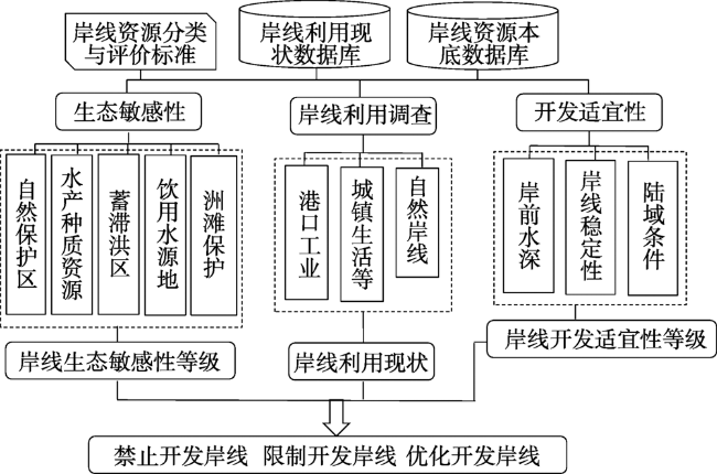
Fig. 1 Comprehensive evaluation and zoning technology of waterfront resources图1 岸线资源综合评价及分区技术 |
Table 2 Management and control method of waterfront resources表2 岸线资源管控分区方法 |
| 功能划定 | 经济功能价值等级 | 生态功能价值等级 | 现状类型 | 解释 |
|---|---|---|---|---|
| 禁止开发岸线 | 不限 | 高于一定等级 | 不限 | 生态功能价值二级以上岸段划定为禁止开发岸线,包含国家级自然保护区、省级自然保护区核心区和缓冲区涉及岸段、国家水产种质资源保护区核心区涉及岸段、重要蓄滞洪区涉及岸段、饮用水水源地涉及岸段、自然滩地和洲滩湿地岸段及其他生态敏感目标空间重叠岸段,旨在有针对性、全面地保护具有重要生态价值的岸线资源 |
| 优化开发岸线 | 不限 | 低于一定等级 | 人工岸线 | 已开发利用岸线(人工岸线)中生态功能价值低于二级的岸段划定为优化开发岸线,旨在充分保障生态价值岸线的基础上促进岸线资源存量优化 |
| 优于一定等级 | 低于一定等级 | 自然岸线 | 未开发利用岸线(自然岸线)中不涉及生态环境敏感目标(生态功能价值低于一级)、开发适宜条件较好的岸段(经济功能价值优于或等于二级)划定为优化开发岸段,旨在充分挖掘岸线资源利用潜力和效率 | |
| 限制开发岸线 | 不限 | 不限 | 不限 | 其余生态功能价值和经济功能价值皆不突出的岸线划定为限制开发岸线,严格限制开发强度和方式 |
Table 3 Standard for assessing the value of waterfront economic function表3 岸线经济功能价值评估准则 |
| 岸段 | 离岸距离/m | 岸前水深/m | 岸线稳定性 | 后方陆域纵深/km | 岸线经济功能价值 | 分级 |
|---|---|---|---|---|---|---|
| 合江门—葛洲坝 | 100 | >10 | 稳定 | >1 | 价值高 | I级 |
| 100 | 5~10 | 稳定 | 0.5~1 | 价值较高 | II级 | |
| 100 | <5 | 不稳定 | <0.5 | 价值低 | II级 | |
| 葛洲坝—南京新济洲 | 200 | >10 | 稳定 | >2 | 价值高 | I级 |
| 200 | 5~10 | 稳定 | 0.5~2 | 价值较高 | II级 | |
| 200 | <5 | 不稳定 | <0.5 | 价值低 | II级 | |
| 南京新济洲—长江口 | 300 | >10 | 稳定 | >2 | 价值高 | I级 |
| 300 | 5~10 | 稳定 | 0.5~2 | 价值较高 | II级 | |
| 300 | <5 | 不稳定 | <0.5 | 价值低 | II级 |
Table 4 Standard for defining the value level of waterfront ecological function表4 岸线生态功能价值等级划定标准 |
| 分级 | 一级 | 二级 | 三级 | 四级 | 五级 |
|---|---|---|---|---|---|
| 分值 | ≤1 | 2~3 | 4~5 | 6~7 | ≥8 |
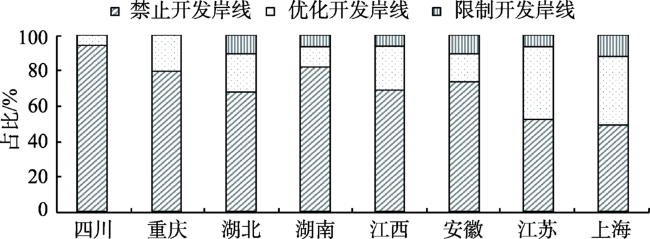
Fig. 2 Proportion of types of waterfront management and control zones in the provinces along the Yangtze River图2 沿江各省市岸线管控分区类型比例 |
Table 5 The key ecological value protection section of Yangtze river waterfront Resources表5 长江岸线资源重点生态价值保护岸段 |
| 岸段名称 | 生态价值表现和保护重点 | 长度/km |
|---|---|---|
| 刀鲚等水产种质资源重点保护岸段 | 重要水产种质资源的主要生长繁育区域 | 609 |
| 防洪蓄洪重点保护岸段 | 防洪安全 | 112 |
| 水源地重点保护岸段 | 饮用水安全 | 155 |
| 长江干流江心洲重点保护岸段 | 江心洲湿地及水生动物密集活动区域 | 698 |
| 长江干流四大家鱼重点保护岸段 | 四大家鱼主要生长繁育区域 | 537 |
| 长江干流洲滩湿地重点保护岸段 | 洲滩湿地水生动物栖息地及自然水陆交互带 | 622 |
| 长江口湿地重点保护岸段 | 长江口重要湿地 | 103 |
| 长江上游消落带重点保护岸段 | 消落带自然水陆交互及临水山地生态 | 1238 |
| 长江上游珍稀特有鱼类重点保护岸段 | 珍稀特有鱼类栖息地 | 706 |
| 长江豚类重点保护岸段 | 豚类栖息地及密集分布岸段 | 688 |
| 中华鲟重点保护岸段 | 中华鲟洄游繁殖栖息地 | 65 |
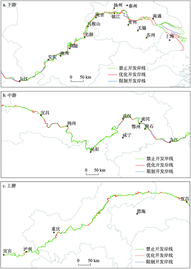
Fig. 3 Planning of types of waterfront management and control along the Yangtze River图3 长江岸线管控分区 |
| [1] |
[
|
| [2] |
[
|
| [3] |
[
|
| [4] |
[
|
| [5] |
|
| [6] |
[
|
| [7] |
[
|
| [8] |
[
|
| [9] |
|
| [10] |
[
|
| [11] |
[
|
| [12] |
[
|
| [13] |
[
|
| [14] |
[
|
| [15] |
[
|
| [16] |
[
|
| [17] |
[
|
| [18] |
[
|
| [19] |
[
|
| [20] |
[
|
| [21] |
|
| [22] |
|
| [23] |
|
| [24] |
|
| [25] |
[
|
| [26] |
[
|
| [27] |
[
|
/
| 〈 |
|
〉 |