
JOURNAL OF NATURAL RESOURCES >
Intercomparison and evaluation of influencing factors among different LAI products over mountainous areas
Received date: 2018-08-03
Request revised date: 2018-12-15
Online published: 2019-02-28
Copyright
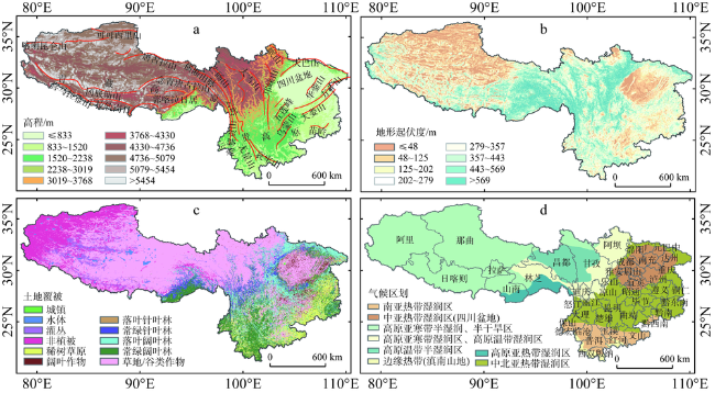
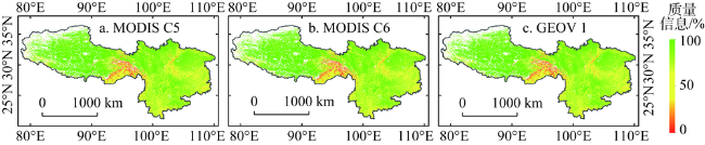
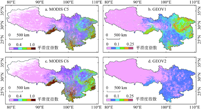
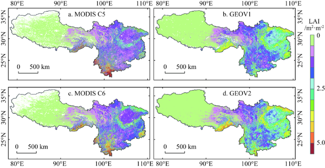
The validation of LAI products not only provides quantitative quality description, but also plays an important part in the improvement of retrieval algorithm and understanding of uncertainties regarding to land surface process models over rugged surfaces. This study evaluated the performance of MODIS (C5, C6), Geoaldn2 (GEOV1, GEOV2) LAI products using intercomparison methods over Southwestern China. The spatiotemporal distribution of integrity and consistencies, such as the percentage of main algorithm, smoothness index, average value during growing season, yearly mean LAI bias and root mean square error (RMSE), respectively, were investigated during the period 2001-2016. Meanwhile, different versions of the same data source LAI products were compared so as to get a clear understanding of improvement about the new one over heterogeneously hilly regions. Lastly, four factors, such as topography (altitude and relief amplitude), vegetation types, and climate regionalization were selected to assess the influence of different underlying surfaces on LAI products using the Geodetector. The results show that spatial and temporal consistency of these LAI products is good over most areas. All LAI products exhibit a higher percentage of good quality data (i. e. successful retrieval) in mountainous areas, and GEOV2 LAI is higher than others. The percentage in altitude and higher relief amplitude area seems to be low. GEOV2 LAI shows smoother temporal profiles than others, and Geoland2 is smoother than MODIS LAI. It is clear that MODIS C5 is smoother than MODIS C6, and GEOV2 is superior to GEOV1. RMSE and yearly mean LAI bias between one and another LAI product are vulnerable to topographic indices, especially to altitude. Q-statistic in Geodetector is smallest related to relief amplitude, biggest to vegetation for MODIS LAI product, and biggest to climate for Geoland2 LAI. Altitude, vegetation, and climate play a dominant role in spatial distribution of LAI. The validation experience demonstrates the importance of topography, vegetation and climate for LAI estimation over mountainous areas. Considerable attention will be paid to the production of higher quality LAI products in topographically complex terrain.
JING Jin-cheng , JIN Hua-an , TANG Bin , LI Ai-nong . Intercomparison and evaluation of influencing factors among different LAI products over mountainous areas[J]. JOURNAL OF NATURAL RESOURCES, 2019 , 34(2) : 400 -411 . DOI: 10.31497/zrzyxb.20190215
Table 1 Introduce of different version LAI product about MODIS C5, C6, GEOV1 and GEOV2表1 不同版本LAI产品介绍 |
| 产品 | 时间范围 | 分辨率 | 算法 | 合成/天 | 最大值 | 来源 | |
|---|---|---|---|---|---|---|---|
| 空间 | 时间/天 | ||||||
| MODIS C5 (MOD15A2) | 2000-02-18至今 | 1 km | 8 | 主算法:三维辐射传输模型构建查找表 备用算法:LAI-NDVI线性关系 | 8 | 10 | 文献[4] |
| MODIS C6 (MOD15A2H) | 2000-02-18至今 | 500 m | 8 | 8 | 10 | 文献[5] | |
| GEOV1 | 1999年至今 | 1/112° | 10 | 人工神经网络(CYC和MOD融合) | 30 | 7 | 文献[24] |
| GEOV2 | 1999年至今 | 1/112° | 10 | ±60 | 7 | 文献[6] | |
注:CYC、MOD分别表示CYCLOPES和MODIS。 |
Fig. 2 Percentage of good quality data for MODIS C5, MODIS C6 and GEOV1图2 LAI产品质量信息 |
Fig. 3 Temporal smoothness index for MODIS C5, MODIS C6, GEOV1 and GEOV2图3 LAI产品平滑度指数 |
Fig. 4 Mean LAI in growing season for MODIS C5, MODIS C6, GEOV1, GEOV2 during 2001-2016图4 2001-2016年生长季LAI均值 |
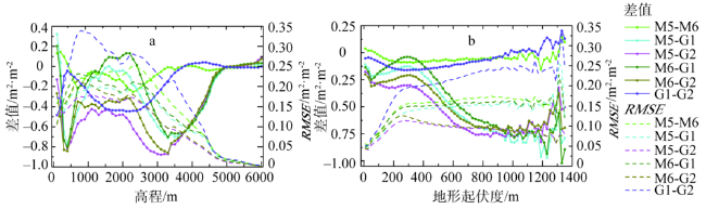
Fig. 5 Statistical indicators (bias, RMSE) among different LAI products, related to altitude and relief amplitude图5 不同LAI产品差值和RMSE随地形因子的变化 |
Table 2 The detection of all the influencing factors表2 各影响因子探测结果 |
| LAI产品 | 交互探测 | ||||
|---|---|---|---|---|---|
| 高程 | 地形起伏度 | 气候区 | 植被类型 | ||
| MOIDS C5 | 高程 | 0.4597 | |||
| 地形起伏度 | 0.5139 | 0.0692 | |||
| 气候区 | 0.5740 | 0.5297 | 0.4865 | ||
| 植被类型 | 0.6070 | 0.5290 | 0.6389 | 0.5201 | |
| MOIDS C6 | 高程 | 0.5321 | |||
| 地形起伏度 | 0.6035 | 0.0891 | |||
| 气候区 | 0.6373 | 0.5837 | 0.5233 | ||
| 植被类型 | 0.7531 | 0.6748 | 0.7579 | 0.6635 | |
| GEOV 1 | 高程 | 0.6414 | |||
| 地形起伏度 | 0.7079 | 0.1139 | |||
| 气候区 | 0.7209 | 0.6579 | 0.6040 | ||
| 植被类型 | 0.7438 | 0.5598 | 0.7409 | 0.5439 | |
| GEOV 2 | 高程 | 0.7064 | |||
| 地形起伏度 | 0.7617 | 0.1063 | |||
| 气候区 | 0.7743 | 0.6997 | 0.6488 | ||
| 植被类型 | 0.8052 | 0.6275 | 0.7956 | 0.6165 | |
The authors have declared that no competing interests exist.
| [1] |
|
| [2] |
|
| [3] |
|
| [4] |
|
| [5] |
|
| [6] |
|
| [7] |
|
| [8] |
|
| [9] |
|
| [10] |
|
| [11] |
|
| [12] |
|
| [13] |
|
| [14] |
[
|
| [15] |
|
| [16] |
|
| [17] |
[
|
| [18] |
|
| [19] |
|
| [20] |
[
|
| [21] |
[
|
| [22] |
|
| [23] |
|
| [24] |
|
| [25] |
|
| [26] |
|
| [27] |
|
| [28] |
[
|
| [29] |
|
| [30] |
|
| [31] |
[
|
| [32] |
|
| [33] |
|
| [34] |
|
| [35] |
|
/
| 〈 |
|
〉 |