
多目标协同管理下的脆弱区国家公园功能分区评估框架——以卡拉麦里国家公园为例
|
李基才(1974- ),男,新疆乌鲁木齐人,博士,研究方向为数据挖掘与自然保护地规划等。E-mail: lijicai19@mails.ucas.ac.cn |
收稿日期: 2024-10-21
修回日期: 2024-12-02
网络出版日期: 2025-05-26
基金资助
国家自然科学基金项目(12071458)
A framework for functional zoning assessment of national parks under multi-objective collaborative management: A case study of Kalamaili National Park in Xinjiang, China
Received date: 2024-10-21
Revised date: 2024-12-02
Online published: 2025-05-26
李基才 , 田英杰 . 多目标协同管理下的脆弱区国家公园功能分区评估框架——以卡拉麦里国家公园为例[J]. 自然资源学报, 2025 , 40(6) : 1605 -1619 . DOI: 10.31497/zrzyxb.20250611
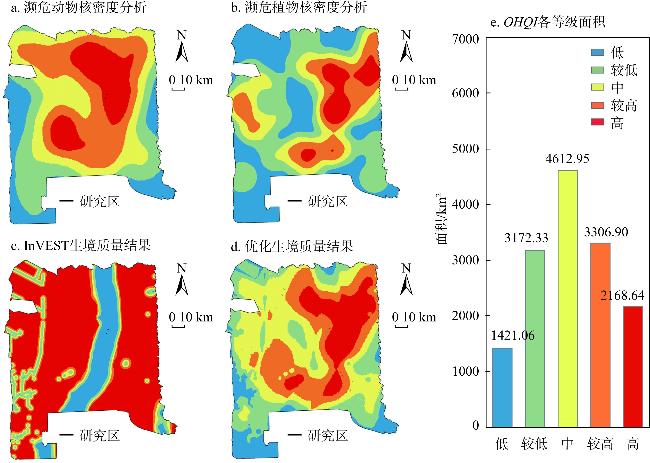
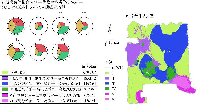
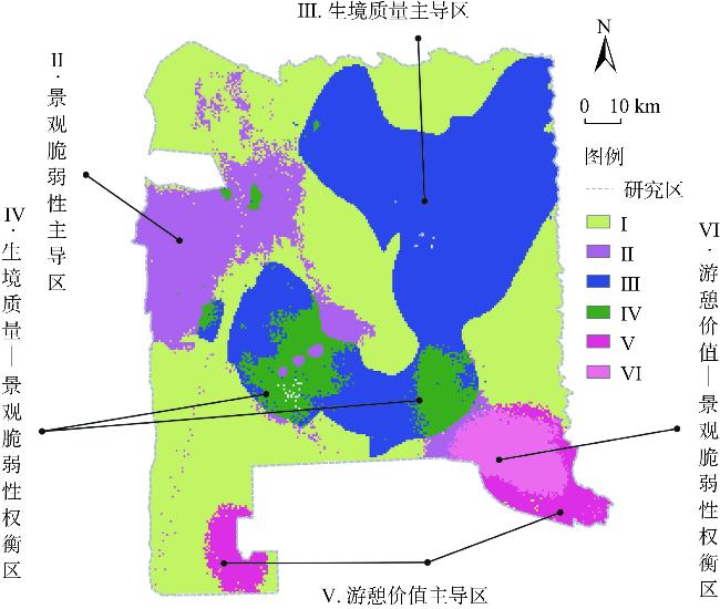
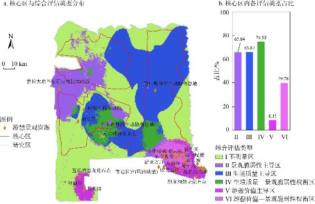
National parks represent a country's most important natural landscapes, unique heritage sites, and areas of rich biodiversity within the natural ecosystem. Their primary function is to protect the authenticity and integrity of vital natural ecosystems while supporting scientific research, education, and recreation. The scientific delimitation of functional divisions in national parks and identification of suitable space for conservation and utilization is of great significance for achieving multi-objective collaborative management of national parks. We developed a functional zoning analysis method for national parks based on a multi-dimensional framework combining recreation value, habitat quality, and landscape vulnerability. Our innovative approach optimized the measurement of habitat quality and landscape vulnerability indices. Using Kalamaili National Park in Xinjiang as a case study, our comprehensive evaluation revealed that areas with high recreation value, landscape vulnerability, and habitat quality showed distinct spatial distribution patterns. High recreational value areas were primarily distributed in the southeast and southwest zones, covering approximately 1200 km2. High habitat quality areas were largely concentrated in the central region, encompassing roughly 2168.64 km2. Areas of high landscape vulnerability were found in the east and south, spanning about 3310.25 km2. Through spatial overlay analysis, we identified six functional clusters. According to these distribution patterns of functional clusters, we proposed planning recommendations for Kalamaili National Park's scientific development. The functional zoning assessment framework in this paper effectively identifies the functional combination and layout of national parks. It provides scientific evaluation methods and decision support for park management and sustainable development, helping promote the harmony between humans and nature.
表1 数据来源Table 1 Data sources |
| 数据 | 数据类型 | 时间/年 | 来源 |
|---|---|---|---|
| DEM | 栅格/30 m | 2019 | 地理空间数据云(https://www.gscloud.cn/) |
| 土地利用/覆被 | 栅格/30 m | 2020 | GlobeLand 30(http://globeland30.org/) |
| NDVI | 栅格/30 m | 2012/2022 | 乌鲁木齐卫星气象站(http://xj.cma.gov.cn/) |
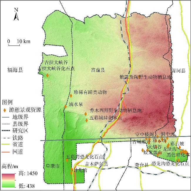
| 优质景观资源点 | 矢量 | 2022 | 《卡拉麦里国家公园科考报告》 |
| 濒危动、植物分布点 | |||
| 交通道路 | |||
| 工矿点 |
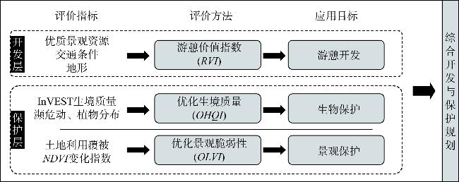
表2 游憩价值指数构建数据与方法Table 2 Data and methods for developing the recreation value index |
| 影响因子 | 分析方法 | 权重 |
|---|---|---|
| 优质景观资源 | 核密度分析法(KDE) | 0.45 |
| 交通 | 欧氏距离(ED) | 0.30 |
| 地形 | 坡度指数(SI) | 0.25 |
表3 生态胁迫因子属性表Table 3 Attribute of ecological stress factors |
| 威胁因子 | 权重 | 空间衰退类型 |
|---|---|---|
| 交通设施 | 0.4 | 线性 |
| 工矿点 | 0.3 | 指数 |
| 人造用地 | 0.3 | 指数 |
表4 各土地利用类型对生境威胁因子的敏感度Table 4 Sensitivity of various land use types to habitat threat factors |
| 土地利用/覆盖类型 | 生境适宜度 | 交通设施 | 工矿点 | 人造用地 |
|---|---|---|---|---|
| 林地 | 1 | 0.8 | 0.9 | 0.9 |
| 草地 | 1 | 0.7 | 0.9 | 0.9 |
| 灌木 | 1 | 0.7 | 0.9 | 0.9 |
| 湿地 | 1 | 0.4 | 0.6 | 0.6 |
| 水体 | 1 | 0.4 | 0.6 | 0.6 |
| 人造用地 | 0 | 0 | 0 | 0 |
| 荒漠戈壁 | 0.8 | 0.4 | 0.6 | 0.6 |
表5 生境质量指数的构建数据与方法Table 5 Construction data and methods of habitat quality index |
| 影响因子 | 分析方法 | 权重 |
|---|---|---|
| InVEST生境质量 | Habitat quality模块 | 0.25 |
| 濒危动物分布 | 核密度分析法 | 0.35 |
| 濒危植物分布 | 核密度分析法 | 0.40 |
| [1] |
连虎刚, 刘春芳, 倪博文, 等. 西北干旱区自然保护地体系生态网络构建及优化: 以河西走廊为例. 应用生态学报, 2024, 10(15): 1-15.
[
|
| [2] |
何思源. 中国国家公园治理中的社区角色及其巩固与发展. 自然资源学报, 2024, 39(10): 2310-2334.
[
|
| [3] |
张玉钧, 薛冰洁. 国家公园开展生态旅游和游憩活动的适宜性探讨. 旅游学刊, 2018, 33(8): 14-16.
[
|
| [4] |
|
| [5] |
高扬仪, 朱里莹, 庄迎鑫, 等. 武夷山国家公园(福建区域)生态系统文化服务簇识别及影响因素. 应用生态学报, 2024, 10(15): 1-12.
[
|
| [6] |
李树信. 国家文化公园的功能、价值及实现途径. 中国经贸导刊(中), 2021, (3): 152-155.
[
|
| [7] |
|
| [8] |
|
| [9] |
王琦, 王辉, 虞虎. 基于生态安全格局的国家公园边界划定: 以雅鲁藏布大峡谷国家公园为例. 自然资源学报, 2023, 38(4): 951-965.
[
|
| [10] |
欧阳志云, 王效科, 苗鸿. 中国陆地生态系统服务功能及其生态经济价值的初步研究. 生态学报, 1999, 19(5): 19-25.
[
|
| [11] |
何思源, 苏杨, 王蕾, 等. 国家公园游憩功能的实现: 武夷山国家公园试点区游客生态系统服务需求和支付意愿. 自然资源学报, 2019, 34(1): 40-53.
[
|
| [12] |
陈利顶, 李秀珍, 傅伯杰, 等. 中国景观生态学发展历程与未来研究重点. 生态学报, 2014, 34(12): 3129-3141.
[
|
| [13] |
刘淼, 史思雪, 张廷爽, 等. 景观生态学在国土空间规划中的应用与展望. 应用生态学报, 2024, 35(9): 2372-2381.
[
|
| [14] |
欧阳志云, 刘建国, 肖寒, 等. 卧龙自然保护区大熊猫生境评价. 生态学报, 2001, 21(11): 1869-1874.
[
|
| [15] |
樊杰. “人地关系地域系统”是综合研究地理格局形成与演变规律的理论基石. 地理学报, 2018, 73(4): 597-607.
[
|
| [16] |
|
| [17] |
|
| [18] |
申宇, 程浩, 刘国华, 等. 基于生物多样性和生态系统服务的青藏高原保护优先区和保护空缺识别. 生态学报, 2024, 44(11): 4507-4516.
[
|
| [19] |
|
| [20] |
孔凡斌, 段淑慧, 徐彩瑶. 基于生态系统服务和生态敏感性的生态安全格局构建: 以钱塘江流域为例. 生态学报, 2024, https://doi.org/10.20103/j.stxb.202312222796.
[
|
| [21] |
|
| [22] |
高帅帅, 胡杨, 邵长亮, 等. 气候变化背景下卡拉麦里国家公园蒙古野驴适宜生境脆弱性评价. 兽类学报, 2024, 44(3): 287-296.
[
|
| [23] |
林晓麟, 丁建斌, 肖华, 等. 卡拉麦里温带荒漠生态系统典型原真代表. 森林与人类, 2024, (2): 6-19.
[
|
| [24] |
谢丽钧, 杨广斌, 王仁儒, 等. 贵州省土地利用变化频数分布及驱动因素. 水土保持通报, 2024, 44(4): 330-339.
[
|
| [25] |
|
| [26] |
马月伟, 潘健峰, 蔡思青, 等. 生态系统服务社会价值与生态价值的权衡与协同关系: 以普达措国家公园为例. 地理科学, 2022, 42(7): 1283-1294.
[
|
| [27] |
张佳宝, 乌恩. 基于游客感知价值的国家公园游憩功能研究: 以黄石国家公园和武夷山国家公园为例. 世界地理研究, 2023, 32(2): 146-157.
[
|
| [28] |
|
| [29] |
|
| [30] |
|
| [31] |
陈实, 黄银兰, 金云翔. 退耕还林(草)工程实施前后黄河中游生境质量时空变化分析. 干旱区研究, 2023, 40(3): 456-468.
[
|
| [32] |
黄木易, 岳文泽, 冯少茹, 等. 基于InVEST模型的皖西大别山区生境质量时空演化及景观格局分析. 生态学报, 2020, 40(9): 2895-2906.
[
|
| [33] |
谢余初, 巩杰, 张素欣, 等. 基于遥感和InVEST模型的白龙江流域景观生物多样性时空格局研究. 地理科学, 2018, 38(6): 979-986.
[
|
| [34] |
|
| [35] |
王帅, 李丹. 基于景观指数的生态用地脆弱度评价研究. 测绘与空间地理信息, 2021, 44(12): 68-71.
[
|
| [36] |
|
/
| 〈 |
|
〉 |