
国土空间规划实施监测网络中多源数据融合路径研究——以高铁网络发展评估的应用实践为例
|
赵毅(1979- ),男,辽宁营口人,博士,研究员级高级城市规划师,研究方向为国土空间规划、国土空间规划实施监测、生态产品价值实现、儿童友好城市建设等。E-mail: 109338801@qq.com |
收稿日期: 2024-04-01
修回日期: 2024-07-23
网络出版日期: 2024-12-16
基金资助
中国博士后科学基金项目(2022M710669)
江苏省重点研发计划社会发展项目(BE2023799)
江苏省自然科学基金项目(BK20211371)
Exploring the development path of multi-source data fusion for China Spatial Planning Observation Network: Using the application of high-speed railway network development evaluation as an example
Received date: 2024-04-01
Revised date: 2024-07-23
Online published: 2024-12-16
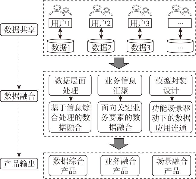
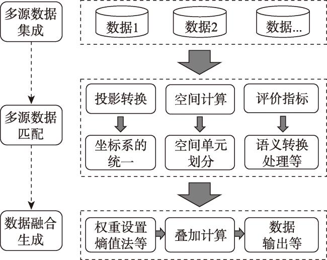
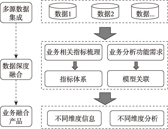
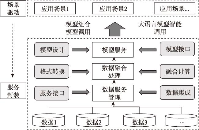
当前,国土空间规划实施监测网络正处于探索和建设的关键时期,数字化技术在国土空间治理体系中成为前沿焦点。其中,多源数据融合作为国土空间规划实施监测网络建设的基础,对于国土空间规划研究和实践至关重要。然而,当前学界对于多源数据融合内涵的认识和应用路径仍未清晰。为此,提出从数据综合、业务发展和应用场景三个角度出发,建立国土空间规划实施监测背景下数据融合的技术实现路径框架,以高铁网络发展评估为应用案例进行辨析。从基于信息综合处理的数据融合、面向关键业务要素的数据融合以及功能场景驱动下的数据应用连通等三个方面,对具体技术实现路径和实施效果进行了阐述。同时,重点讨论了多源数据融合的关键内容、实践价值以及政策建议,期望为提升国土空间治理现代化水平发挥重要支撑性作用。
赵毅 , 韦胜 , 郑俊 . 国土空间规划实施监测网络中多源数据融合路径研究——以高铁网络发展评估的应用实践为例[J]. 自然资源学报, 2024 , 39(12) : 2912 -2923 . DOI: 10.31497/zrzyxb.20241211
At present, China Spatial Planning Observation Network is in a critical stage of exploration and construction, and the development of digital technology in the transformation of national spatial governance system has become a cutting-edge focus. Among them, multi-source data fusion is crucial for the successful implementation of industry models and applications as the foundation of China Spatial Planning Observation Network. However, the understanding and application paths of different aspects of data fusion have not been fully resolved. Therefore, this study proposes a technical framework for data fusion in the context of land spatial planning implementation monitoring from the perspectives of data integration, business development, and application scenarios, with the high-speed railway network development evaluation as an application case. Then this study elaborates on the specific implementation path and effects of data fusion methods based on data structure features, information integration methods oriented towards key business elements, and data application connectivity methods driven by functional scenarios. Finally, this study discusses the key content, practical value, and policy recommendations of multi-source data fusion, providing fundamental support for improving the modernization level of national spatial governance.
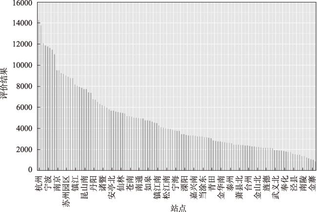
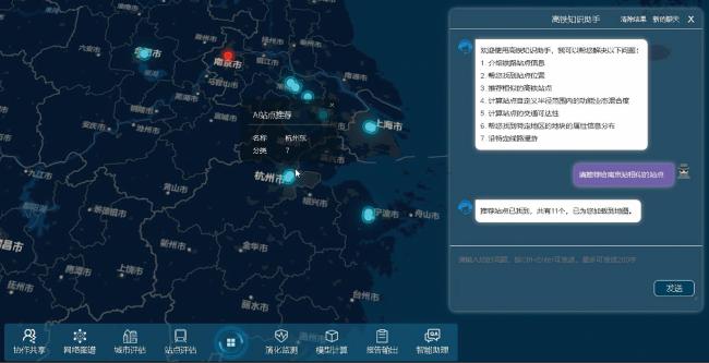
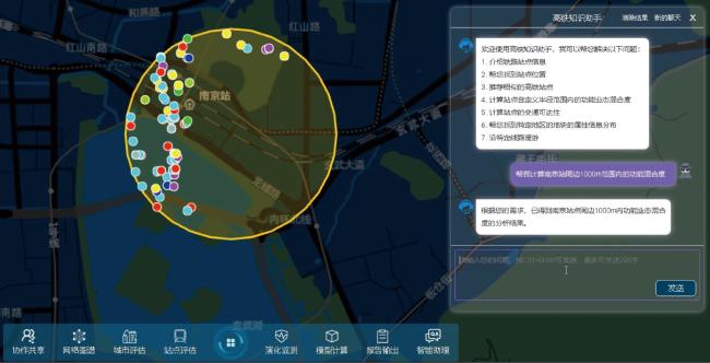
图8 大模型问答方式调用“某些特征相似高铁站点推荐”的功能演示Fig. 8 Demonstration of using the large model Q&A method to call for the function of "recommending high-speed rail stations with similar features" |
| [1] |
钟镇涛, 张鸿辉, 刘耿, 等. 面向国土空间规划实施监督的监测评估预警模型体系研究. 自然资源学报, 2022, 37(11): 2946-2960.
[
|
| [2] |
王伟. 国土空间整体性治理与智慧规划建构路径. 城乡规划, 2019, (6): 11-17.
[
|
| [3] |
孔宇, 甄峰, 李兆中, 等. 智能技术辅助的市(县)国土空间规划编制研究. 自然资源学报, 2019, 34(10): 2186-2199.
[
|
| [4] |
|
| [5] |
刘俊楠, 刘海砚, 陈晓慧, 等. 面向多源地理空间数据的知识图谱构建. 地球信息科学学报, 2020, 22(7): 1476-1486.
[
|
| [6] |
甄峰, 张姗琪, 秦萧, 等. 从信息化赋能到综合赋能: 智慧国土空间规划思路探索. 自然资源学报, 2019, 34(10): 2060-2072.
[
|
| [7] |
|
| [8] |
向雨, 张鸿辉, 刘小平. 多源数据融合的城市体检评估: 以长沙市为例. 热带地理, 2021, 41(2): 277-289.
[
|
| [9] |
刘春杉, 曾元武, 罗宏明, 等. 广东省国土空间规划“一张图”实施监督信息系统下的海洋数据融合研究与实践. 测绘通报, 2022, (6): 154-157.
[
|
| [10] |
何苏燕. 数据生产要素化及其价值创造机制研究. 企业经济, 2023, 42(1): 79-87.
[
|
| [11] |
李满春, 陈振杰, 周琛, 等. 面向“一张图”的国土空间规划数据库研究. 中国土地科学, 2020, 34(5): 69-75.
[
|
| [12] |
赵毅, 周秦, 袁新国, 等. 国土空间规划引领生态产品价值的实现路径. 城市规划学刊, 2022, (5): 59-66.
[
|
| [13] |
徐猛. 基于数据融合和规划场景设定建设多源数据规划应用平台. 上海城市规划, 2018, (1): 57-62.
[
|
| [14] |
荣慧芳, 陶卓民. 基于网络数据的乡村旅游热点识别及成因分析: 以江苏省为例. 自然资源学报, 2020, 35(12): 2848-2861.
[
|
| [15] |
王炼军, 徐恺阳, 蒋源, 等. 成都市实时体检评估体系与技术方法. 规划师, 2024, 40(1): 122-128.
[
|
| [16] |
潘家栋, 肖文, 唐楠. 数据要素赋能创新模式演进. 社会科学战线, 2024, (3): 51-58.
[
|
| [17] |
项波, 温婷, 郭汉, 等. 时空数据融合的自然遗产地监测与保护管理平台设计方案研究. 中国园林, 2020, 36(11): 95-99.
[
|
| [18] |
蒋秉川, 万刚, 许剑, 等. 多源异构数据的大规模地理知识图谱构建. 测绘学报, 2018, 47(8): 1051-1061.
[
|
| [19] |
陈彪, 彭欣月, 周素红, 等. 基于多源数据融合的农村建筑智能识别与三维建模方法研究. 热带地理, 2023, 43(2): 190-201.
[
|
| [20] |
白婷, 邓实权, 熊花, 等. 基于人工智能和遥感技术的城市更新单元识别方法研究及应用. 自然资源学报, 2023, 38(6): 1517-1531.
[
|
| [21] |
张良培, 何江, 杨倩倩, 等. 数据驱动的多源遥感信息融合研究进展. 测绘学报, 2022, 51(7): 1317-1337.
[
|
| [22] |
刘纪平, 王勇, 胡燕祝, 等. 互联网泛在地理信息感知融合技术综述. 测绘学报, 2022, 51(7): 1618-1628.
[
|
| [23] |
吴欣玥, 廖家仪, 张晓荣. 基于多源数据融合的成都市职住空间特征及影响因素研究. 规划师, 2023, 39(1): 120-127.
[
|
| [24] |
赵毅, 郑俊, 徐辰, 等. 县级国土空间总体规划编制关键问题. 城市规划学刊, 2022, (2): 54-61.
[
|
| [25] |
辛鲁斌, 韩玲, 李良志. 基于多源数据融合的滑坡智能识别. 地球科学与环境学报, 2023, 45(4): 920-928.
[
|
/
| 〈 |
|
〉 |