
国土空间规划实施监测网络(CSPON)算法模型体系构建及应用
|
张鸿辉(1980- ),男,湖南长沙人,博士,教授级高级工程师,研究方向为智慧国土空间规划及地理空间智能。E-mail: 249536073@qq.com |
收稿日期: 2024-04-29
修回日期: 2024-08-09
网络出版日期: 2024-12-16
基金资助
国家自然科学基金项目(41871318)
国家自然科学基金项目(42171410)
国家重点研发计划课题(2023YFC3804804)
Construction and application of algorithm model system for China Spatial Planning Observation Network (CSPON)
Received date: 2024-04-29
Revised date: 2024-08-09
Online published: 2024-12-16
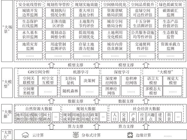
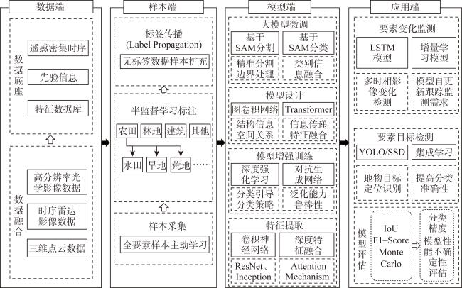
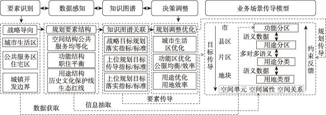
国土空间规划实施监测网络(CSPON)是打造“可感知、能学习、善治理、自适应”的智慧规划,推进国土空间治理“数智化”转型的重要手段。针对当前CSPON建设亟需科学系统技术方法支撑的需要,系统回顾国内外CSPON算法模型相关研究的发展历程与现状问题,在此基础上,提出以“大算力”“大数据”“大模型”技术为支撑,以“大场景”应用为导向的CSPON算法模型技术框架,重点分析“算力、数据、模型、场景”四大核心要素在CSPON算法模型建设中的定位与作用及其相互耦合机理。结合实践案例阐述CSPON算法模型在安全底线管控、规划传导管控、规划实施评估、空间格局优化等国土空间规划实施监测典型场景中的应用。研究结果可为加快推进CSPON技术方法完善与实践应用落地提供科学依据。
张鸿辉 , 钟镇涛 , 杨丽娅 , 崔学森 , 徐华键 , 李文静 . 国土空间规划实施监测网络(CSPON)算法模型体系构建及应用[J]. 自然资源学报, 2024 , 39(12) : 2853 -2868 . DOI: 10.31497/zrzyxb.20241207
The construction of the China Spatial Planning Observation Network (CSPON) is a crucial means to promote intelligent planning, that is "perceptive, capable of learning, good at governance, and self-realizing." It is also a key support for building a green and smart digital ecological civilization. Addressing the urgent need for scientific and systematic technical methods in CSPON construction, this paper explores the methodological approach for CSPON algorithm model construction and application. It proposes a CSPON algorithm model technical framework supported by "high-performance computing", "big data", and "large model" technologies, oriented towards "large-scale scenario" applications. The paper illustrates its application in typical spatial planning implementation monitoring scenarios such as safety baseline control, planning transmission control, planning implementation assessment, and spatial pattern optimization through practical cases. The research indicates that: (1) "High-Performance Computing" is the foundation supporting CSPON's growing demands for high-frequency data processing and dynamic computational analysis. It should fully integrate modern computing architectures such as cloud computing, edge computing, and distributed computing to strengthen CSPON's computational foundation. (2) "Big Data" is the cornerstone for constructing and operating CSPON algorithm model systems. The integration and mining of multi-source big data from "space, aerial, ground, sea, and network" can support algorithm models in more comprehensively and accurately characterizing complex spatial systems. (3) "Large Model" is the "intelligent core" of CSPON. The "multi-model parallel use" mode, integrating traditional "small models" like GIS spatial analysis and machine learning algorithms with generative "large models" such as language and vision models, will become the mainstream trend in CSPON algorithm model application and development. (4) "Large-scale Scenarios" serve as the application carrier and target of CSPON. They should establish application scenarios combining "common scenarios" and "personalized scenarios" based on local characteristics and business needs, fully leveraging the roles and advantages of different CSPON algorithm models. The research results provide a scientific basis for accelerating the improvement of CSPON technical methods and their practical application.
| [1] |
中华人民共和国自然资源部. 自然资源部办公厅关于印发《全国国土空间规划实施监测网络建设工作方案(2023—2027年)》的通知. https://gi.mnr.gov.cn/202309/t20230908_2799702.html, 2023-09-05.
[Ministry of Natural Resources of the People's Republic of China. Notice of the General Office of the Ministry of Natural Resources on Issuing the Work Plan for the Construction of the National Land and Space Planning Implementation Monitoring Network (2023-2027). https://gi.mnr.gov.cn/202309/t20230908_2799702.html, 2023-09-05.]
|
| [2] |
蔡玉梅. CSPON建设的基本思路和总体框架. 中国土地, 2024, (5): 9-13.
[
|
| [3] |
国土空间规划实施监测网络关键技术研发与应用项目团队. 监测国土空间发展格局, 促进空间治理数字化转型. 中国土地, 2023, (12): 22-28.
[Key Technology Research and Application Project Team for Monitoring Network Implementation of National Spatial Planning. Monitor the spatial development pattern of the land and promote the digital transformation of spatial governance. China Land, 2023, (12): 22-28.]
|
| [4] |
王伟, 柳泽, 林俞先, 等. 从国土空间规划“一张图”到CSPON“一张网”学术笔谈. 北京规划建设, 2024, (1): 52-65.
[
|
| [5] |
董云皓, 李长风, 高宇佳. 关于国土空间规划实施监督子系统建设方法的思考: 以上海市规划驾驶舱建设为例. 上海城市规划, 2022, (4): 43-48.
[
|
| [6] |
王伟, 罗亚, 赵迪, 等. CSPON视阈下“数字国土新生态”的内涵、体系与营造. 中国土地, 2024, (5): 14-19.
[
|
| [7] |
侯静轩, 潘海霞, 罗杰. 国土空间规划实施监测网络建设的内涵解析及展望. 规划师, 2024, 40(3): 1-6.
[
|
| [8] |
吴彤, 甄峰, 孔宇, 等. 人工智能技术赋能城市空间治理的模式与路径研究. 规划师, 2024, 40(3): 14-21.
[
|
| [9] |
罗杰. 引领国土空间治理“数智化”转型的系统工程: 全国国土空间规划实施监测网络建设的方法路径探讨. 中国土地, 2024, (5): 4-8.
[
|
| [10] |
王晓莉, 胡业翠, 牛帅, 等. 国土空间规划实施监测评估指标体系构建的探讨. 中国土地, 2024, (2): 32-35.
[
|
| [11] |
张鸿辉, 洪良, 罗伟玲, 等. 面向“可感知、能学习、善治理、自适应”的智慧国土空间规划理论框架构建与实践探索研究. 城乡规划, 2019, (6): 18-27.
[
|
| [12] |
钟镇涛, 张鸿辉, 刘耿, 等. 面向国土空间规划实施监督的监测评估预警模型体系研究. 自然资源学报, 2022, 37(11): 2946-2960.
[
|
| [13] |
李明月, 周晓航, 周艺霖. 市县国土空间规划实施监测指标体系研究: 基于生命周期理论的广东省实例分析. 城市规划, 2022, 46(6): 57-67.
[
|
| [14] |
|
| [15] |
|
| [16] |
|
| [17] |
|
| [18] |
|
| [19] |
|
| [20] |
刘慧, 樊杰, 王传胜. 欧盟空间规划研究进展及启示. 地理研究, 2008, 27(6): 1381-1389.
[
|
| [21] |
马里奥·赖默, 希帕纳约蒂斯·格蒂米斯, 德汉斯·海因里希·布洛特福格尔编著. 欧洲空间规划体系与实践:比较视角下的延续与变革. 贺璟寰译. 北京: 中国建筑工业出版社, 2022: 8-30.
[
|
| [22] |
江志勇. 城市总体规划指标体系系统运用研究: 国内外实证比较评述. 深圳: 深圳大学, 2011.
[
|
| [23] |
苏建忠, 杨成韫. 英国和加拿大规划监测评估的最新进展及启示. 国际城市规划, 2015, 30(5): 52-56.
[
|
| [24] |
周姝天, 翟国方, 施益军. 英国空间规划的指标监测框架与启示. 国际城市规划, 2018, 33(5): 126-131.
[
|
| [25] |
李璐. 基于人类行为视角的城市铁路“边缘”空间的更新策略研究. 合肥: 合肥工业大学, 2016.
[
|
| [26] |
梁江, 穆丹, 孙晖. 荷兰国家基础设施与空间规划战略的评估与启示. 国际城市规划, 2014, 29(6): 72-80, 86.
[
|
| [27] |
刘晓丽, 刘佳福, 龚威平, 等. 基于遥感与GIS技术的省域城镇体系规划动态监测研究: 以吉林省为例. 规划师, 2011, 27(10): 81-86.
[
|
| [28] |
代鑫, 刘前媛, 唐鹏, 等. 城市群空间结构演变规律及优化方向研究: 以成都平原经济区为例. 城市规划, 2022, 46(10): 104-114.
[
|
| [29] |
陈蔚珊, 柳林, 梁育填. 基于POI数据的广州零售商业中心热点识别与业态集聚特征分析. 地理研究, 2016, 35(4): 703-716.
[
|
| [30] |
曾坚, 贺蔚杰, 曾穗平. 中国式现代化: 多源数据与人工智能技术支持下的国土空间规划理论框架. 城市学报, 2023, (5): 10-18.
[
|
| [31] |
杨尧, 赵耀龙, 刘小丁, 等. 管理视角下自然资源统一调查监测模式. 自然资源学报, 2023, 38(3): 808-821.
[
|
| [32] |
黄伊婧, 张姗琪, 林昀, 等. 城市级国土空间规划实施监测体系的构建思路与实践探索: 以宁波市为例. 自然资源学报, 2024, 39(4): 823-841.
[
|
| [33] |
李强, 徐斌, 李文睿, 等. 基于PCA-ML-RBF模型的资源环境承载能力监测与空间规划实施情景模拟研究. 地理与地理信息科学, 2020, 36(5): 106-111.
[
|
| [34] |
高杨, 黄华梅, 吴志峰. 基于投影寻踪的珠江三角洲景观生态安全评价. 生态学报, 2010, 30(21): 5894-5903.
[
|
| [35] |
罗亚, 吴洪涛, 张耘逸, 等. 数字化治理下国土空间规划实施监测网络建设路径. 规划师, 2024, 40(3): 7-13.
[
|
| [36] |
孙施文. 基于城市建设状况的总体规划实施评价及其方法. 城市规划学刊, 2015, (3): 9-14.
[
|
| [37] |
李王鸣. 城市总体规划实施评价研究. 杭州: 浙江大学出版社, 2007: 15-100.
[
|
| [38] |
石晓冬, 王吉力, 杨明. 北京城市总体规划实施评估机制的回顾与新探索. 城市规划学刊, 2019, (3): 66-73.
[
|
| [39] |
王亚钧. 从首都到宜居城市: 新世纪北京的城市规划目标. 装饰, 2007, (11): 10-15.
[
|
| [40] |
冯经明. 上海市城市总体规划实施评估若干问题的战略思考. 上海城市规划, 2013, (3): 6-10.
[
|
| [41] |
袁也. 总体规划实施评价方法的主要问题及其思考. 城市规划学刊, 2014, (2): 60-66.
[
|
| [42] |
林丹, 罗彦. 从远景到愿景: 空间战略规划的复兴与编制内容方法分析. 国际城市规划, 2015, 30(5): 31-40.
[
|
| [43] |
刘学博, 户保田, 陈科海, 等. 大模型关键技术与未来发展方向: 从ChatGPT谈起. 中国科学基金, 2023, 37(5): 758-766.
[
|
| [44] |
马祥军, 李朝阳. 香港2030年远景规划及启示. 规划师, 2009, 25(5): 67-72.
[
|
| [45] |
孙凝晖, 张云泉, 刘宇航. 算力|学者谈术语. https://www.ccf.org.cn/Media_list/gzwyh/jsjsysdwyh/2022-11-12/789792.shtml, 2022-11-12.
[
|
| [46] |
李晓晖, 詹美旭, 李飞, 等. 面向实施的市级国土空间规划传导思路与技术方法. 自然资源学报, 2022, 37(11): 2789-2802.
[
|
/
| 〈 |
|
〉 |