
江苏省域鸟类多样性保护格局构建与生态廊道优化
|
沈舟(1996- ),男,浙江嘉兴人,博士研究生,研究方向为城乡生态规划、生物多样性保护。E-mail: shenz9698@163.com |
收稿日期: 2024-01-29
修回日期: 2024-06-11
网络出版日期: 2024-12-16
基金资助
国家重点研发计划项目(2022YFC3802604)
江苏省决策咨询研究基地课题(23SSL069)
安徽省高校优秀科研创新团队(2022AH010021)
Construction of avian biodiversity conservation patterns and optimization of ecological corridors in Jiangsu province
Received date: 2024-01-29
Revised date: 2024-06-11
Online published: 2024-12-16
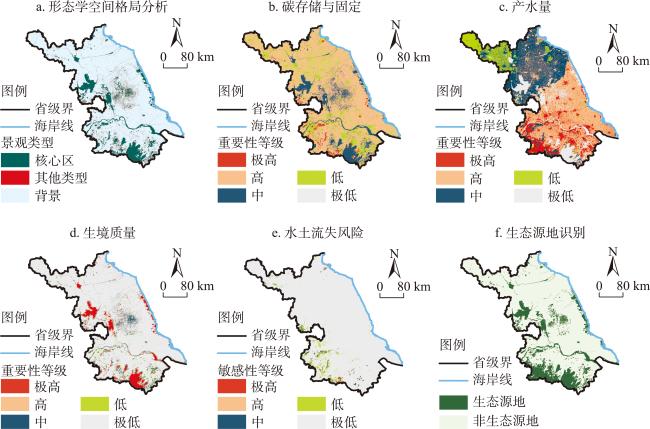
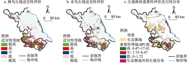
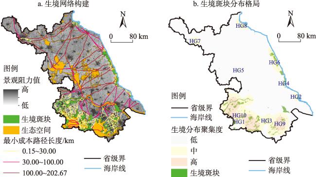
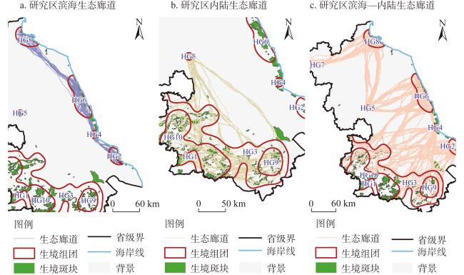
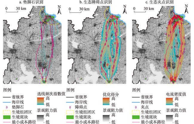
“昆明—蒙特利尔全球生物多样性框架”为2030年及其后全球生物多样性治理描绘了新的愿景,为此中国明确了新时期的战略部署与行动计划。以江苏省为例,通过集成生态系统结构与功能评价方法,综合识别了区域生态源地;利用物种分布模型,在源地空间内确定了64种珍稀林鸟与水鸟的生境斑块;在景观阻力面构建与最小成本路径的基础上,根据斑块分布密度,辨识了不同生境组团区域;利用LSCorridors模型刻画了重要生态廊道的分布范围,并提出了基于“垫脚石—障碍点—夹点”的战略点优化方法。结果表明:(1)研究区生态源地局部聚集度高,但在区域层面上相对隔离,水域是主导型景观,同时也包括大量兼具生态功能的耕地。(2)目标物种生境网络包括692条最小成本路径,其中100 km以上路径有25条,占总长度的36.72%,多为横跨东西的走向。(3)存在十大生境组团区,面积大、范围广的集中在苏南,其余彼此隔离度较高。(4)结合多路径模拟的12条重要生态廊道,普遍具有跨地域特征,且现实中可能呈现多重通道,例如,其中一条需实施114个战略点的多方位优化。研究成果可为新时期中国《生物多样性公约》履约进程、全面推进生物多样性保护主流化,以及国土空间生态保护与修复规划研究与实践提供科学依据。
沈舟 , 尹海伟 , 孔繁花 , 苏杰 , 孙辉 , 盖振宇 , 班玉龙 . 江苏省域鸟类多样性保护格局构建与生态廊道优化[J]. 自然资源学报, 2024 , 39(12) : 2834 -2852 . DOI: 10.31497/zrzyxb.20241206
The Kunming-Montreal Global Biodiversity Framework heralds a transformative vision for global biodiversity governance extending beyond 2030. In alignment with this framework, China has formulated its strategic approach and action plan for biodiversity conservation in the contemporary era. Taking Jiangsu province as a case study, our study explores the methodology of constructing avian diversity conservation patterns and optimizing ecological corridors at a provincial scale. We employed an integrated ecosystem structure and function evaluation method to identify the ecological sources, followed by the utilization of the MaxEnt model to focus on identifying the habitats of 64 species of rare forest birds and water birds within these sources. Based on the landscape resistance surface and least-cost path, we used the kernel analysis method to classify the habitat groups according to patch density. To delineate the spatial extent of ecological corridors, we applied the LSCorridors software package to optimize the proposed ecological corridors by identifying stepping-stones, barriers, and pinch points. Our results show that: (1) Ecological source areas showed a tendency to aggregate locally while remaining regionally isolated. The dominant landscape components included water bodies along with cultivated lands possessing high ecological value. (2) The habitat network for target species comprised 692 least-cost paths, 25 of which extended over 100 km, accounting for 36.72% of the total length, predominantly oriented in an east-west direction. (3) Spatial analysis identified ten distinct habitat groups within the study area, with four concentrated in southern Jiangsu and the others highly isolated. (4) The twelve identified crucial ecological corridors between these groups typically displayed cross-regional characteristics with multiple potential migration routes. For instance, one corridor required optimization at 114 strategic points, including 19 stepping stones, 45 barriers, and 50 pinch points. Our study offers valuable insights for the practical implementation of the Convention on Biological Diversity in China. It supports the comprehensive promotion of mainstreaming biodiversity conservation into ecological protection and restoration planning, serving as a reference for advancing these initiatives.
表1 主要数据及来源Table 1 Data and data sources |
| 数据 | 类型 | 精度 | 数据来源 |
|---|---|---|---|
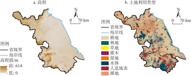
| 土地利用/土地覆被(2020年) | 栅格 | 30 m | 全国地理信息资源目标服务系统(GlobalLand30, https://www.webmap.cn/commres.do?method=globeIndex) |
| 植被覆盖(2000—2020年) | 栅格 | 30 m | 国家科技资源共享服务平台(http://www.nesdc.org.cn) |
| 土壤数据 | 栅格 | 1 km | 世界土壤数据库(HWSD)土壤数据集(HWSD v1.2, https://www.fao.org/soils-portal/soil-survey/soil-maps-and-databases/harmonized-world-soil-database-v12/en/) |
| 降水量(2001—2020年) | 栅格 | 1 km | 国家地球系统科学数据中心(http://www.geodata.cn/) |
| 道路(2023年) | 矢量 | — | OpenStreetMap(https://www.openstreetmap.org/) |
| 高程 | 栅格 | 30 m | 地理空间数据云(https://www.gscloud.cn/) |
| 气候和气候水平衡(2020年) | 栅格 | 4 km | Climate and climatic water balance,Terra Climate(https://www.climatologylab.org/terraclimate.html) |
| 建筑高度(2020年) | 栅格 | 10 m | Zenodo数据分享平台(https://zenodo.org/record/7064268#.YxtVAuxBz0p) |
| 鸟类观测数据(2021—2022年) | 文本 | — | 中国观鸟记录中心(http://www.birdreport.cn/) |
表2 目标物种的种类及名称Table 2 Type and name of the target species |
| 林鸟 | 湿地(水)鸟 | ||||
|---|---|---|---|---|---|
| 序号 | 物种名称 | 序号 | 物种名称 | ||
| 1 | 白鹇 | Lophura nycthemera | 1 | 鸿雁 | Anser cygnoid |
| 2 | 白颈长尾雉* | Syrmaticus ellioti | 2 | 白额雁 | Anser albifrons |
| 3 | 小鸦鹃 | Centropus bengalensis | 3 | 大天鹅 | Cygnus cygnus |
| 4 | 褐翅鸦鹃* | Centropus sinensis | 4 | 小天鹅 | Cygnus columbianus |
| 5 | 鹗 | Pandion haliaetus | 5 | 鸳鸯 | Aix galericulata |
| 6 | 黑翅鸢 | Elanus caeruleus | 6 | 棉凫 | Nettapus coromandelianus |
| 7 | 凤头蜂鹰 | Pernis ptilorhynchus | 7 | 花脸鸭 | Sibirionetta formosa |
| 8 | 黑冠鹃隼 | Aviceda leuphotes | 8 | 青头潜鸭 | Aythya baeri |
| 9 | 蛇雕 | Spilornis cheela | 9 | 斑头秋沙鸭* | Mergellus albellus |
| 10 | 金雕* | Aquila chrysaetos | 10 | 白鹤 | Grus leucogeranus |
| 11 | 林雕 | Ictinaetus malayensis | 11 | 丹顶鹤 | Grus japonensis |
| 12 | 苍鹰 | Accipiter gentilis | 12 | 灰鹤 | Grus grus |
| 13 | 日本松雀鹰 | Accipiter gularis | 13 | 白头鹤 | Grus monacha |
| 14 | 雀鹰 | Accipiter nisus | 14 | 水雉 | Hydrophasianus chirurgus |
| 15 | 赤腹鹰 | Accipiter soloensis | 15 | 半蹼鹬 | Limnodromus semipalmatus |
| 16 | 凤头鹰 | Accipiter trivirgatus | 16 | 小杓鹬 | Numenius minutus |
| 17 | 红隼 | Falco tinnunculus | 17 | 白腰杓鹬 | Numenius arquata |
| 18 | 游隼 | Falco peregrinus | 18 | 大杓鹬 | Numenius madagascariensis |
| 19 | 红脚隼 | Falco amurensis | 19 | 小青脚鹬 | Tringa guttifer |
| 20 | 灰背隼* | Falco columbarius | 20 | 翻石鹬 | Arenaria interpres |
| 21 | 燕隼 | Falco subbuteo | 21 | 大滨鹬 | Calidris tenuirostris |
| 22 | 白尾鹞 | Circus cyaneus | 22 | 勺嘴鹬 | Calidris pygmeus |
| 23 | 灰脸鵟鹰 | Butastur indicus | 23 | 阔嘴鹬 | Calidris falcinellus |
| 24 | 普通鵟 | Buteo japonicus | 24 | 黑嘴鸥 | Saundersilarus saundersi |
| 25 | 长耳鸮 | Asio otus | 25 | 遗鸥 | Ichthyaetus relictus |
| 26 | 短耳鸮 | Asio flammeus | 26 | 东方白鹳 | Ciconia boyciana |
| 27 | 红角鸮 | Otus sunia | 27 | 白琵鹭 | Platalea leucorodia |
| 28 | 领角鸮 | Otus lettia | 28 | 黑脸琵鹭 | Platalea minor |
| 29 | 纵纹腹小鸮 | Athene noctua | 29 | 黄嘴白鹭 | Egretta eulophotes |
| 30 | 领鸺鹠 | Glaucidium brodiei | 30 | 震旦鸦雀 | Paradoxornis heudei |
| 31 | 仙八色鸫 | Pitta nympha | |||
| 32 | 云雀 | Alauda arvensis | |||
| 33 | 画眉 | Garrulax canorus | |||
| 34 | 黄胸鹀 | Emberiza aureola | |||
注:*表示观测时段内无数据记录。 |
表3 物种分布模型中的环境变量选择Table 3 Selection of environmental variables in species distribution models |
| 序号 | 中文名称 | 英文名称 | 模型变量输入名称 | 单位 |
|---|---|---|---|---|
| 1 | 实际蒸散量 | Actual evapotranspiration | Aet | mm |
| 2 | 碳储存与固定 | Carbon storage and sequestration | carbon_s | t |
| 3 | 水分亏缺 | Climate water deficit | def | mm |
| 4 | 海拔 | Elevation | dem | m |
| 5 | 到生态源地的距离 | Distance to ecological sources | dist_eco_sources | m |
| 6 | 到高速公路的距离 | Distance to highways | dist_road_h | m |
| 7 | 到一级公路的距离 | Distance to primary roads | dist_road_p | m |
| 8 | 到铁路的距离 | Distance to railways | dist_road_r | m |
| 9 | 到二级公路的距离 | Distance to secondary roads | dist_road_s | m |
| 10 | 生境质量 | Habitat quality | habitat_q | unitless |
| 11 | 土地利用/土地覆被 | Land use/land cover | land | unitless |
| 12 | 植被覆盖度 | NDVI | ndvi | unitless |
| 13 | 帕尔默干旱指数 | Palmer drought severity index | pdsi | unitless |
| 14 | 潜在蒸散量 | Potential evapotranspiration | pet | mm |
| 15 | 降水 | Precipitation | ppt | mm |
| 16 | 径流 | Runoff | q | mm |
| 17 | 坡度 | Slope | slope | % |
| 18 | 土壤湿度 | Soil moisture | soil | mm |
| 19 | 水土流失敏感性 | Soil loss sensitivity | soil_l | t |
| 20 | 向下的地面短波辐射 | Downward surface shortwave radiation | srad | W/m2 |
| 21 | 雪水当量 | Snow water equivalent | swe | mm |
| 22 | 最高气温 | Maximum temperature | tmax | ℃ |
| 23 | 最低气温 | Minimum temperature | tmin | ℃ |
| 24 | 蒸气压 | Vapor pressure | vap | kPa |
| 25 | 饱和蒸汽压亏缺 | Vapor pressure deficit | vpd | kPa |
| 26 | 产水量 | Water yield | water_y | mm |
| 27 | 风速 | Wind speed | ws | m/s |
表4 景观阻力面构建的指标体系Table 4 The index system of landscape resistance surface construction |
| 评价指标 | 阻力值 | 二级指标权重 | 一级指标权重 | ||
|---|---|---|---|---|---|
| 一级指标 | 二级指标 | 三级指标 | |||
| 土地利用/土地覆被 | 林地、水域、湿地 | — | 1 | — | 0.3113 |
| 耕地 | — | 3 | |||
| 草地、灌木、裸地 | — | 5 | |||
| 建设用地 | — | 7 | |||
| 植被 | 植被覆盖度(NDVI值) | >0.48 | 1 | — | 0.2553 |
| 0.31~0.48 | 3 | ||||
| 0.20~0.31 | 5 | ||||
| <0.20 | 7 | ||||
| 与生态源地距离/km | 面积大于100 km2的生态源地 | 0~3 | 1 | 0.4794 | 0.1864 |
| 3~6 | 3 | ||||
| 6~12 | 5 | ||||
| >12 | 7 | ||||
| 面积大于10~100 km2的生态源地 | 0~2.4 | 1 | 0.3333 | ||
| 2.4~4.8 | 3 | ||||
| 4.8~9.6 | 5 | ||||
| >9.6 | 7 | ||||
| 面积大于10 km2的生态源地 | 0~1.2 | 1 | 0.1873 | ||
| 1.2~2.4 | 3 | ||||
| 2.4~4.8 | 5 | ||||
| >4.8 | 7 | ||||
| 与道路距离/km | 一级公路 | 0~0.45 | 7 | 0.2213 | 0.1098 |
| 0.45~0.60 | 5 | ||||
| 0.60~0.90 | 3 | ||||
| >0.90 | 1 | ||||
| 二级公路 | 0~0.30 | 7 | 0.1639 | ||
| 0.30~0.45 | 5 | ||||
| 0.45~0.60 | 3 | ||||
| >0.60 | 1 | ||||
| 铁路 | 0~0.75 | 7 | 0.3274 | ||
| 0.75~0.90 | 5 | ||||
| 0.90~1.20 | 3 | ||||
| >1.2 | 1 | ||||
| 高速公路 | 0~0.6 | 7 | 0.2874 | ||
| 0.6~0.9 | 5 | ||||
| 0.9~1.2 | 3 | ||||
| >1.2 | 1 | ||||
| 与建筑物距离/km | 建筑高度>30 m的地区 | 0~0.6 | 7 | 0.5279 | 0.1372 |
| 0.6~1.2 | 5 | ||||
| 1.2~3.6 | 3 | ||||
| >3.6 | 1 | ||||
| 建筑高度10~30 m的地区 | 0~0.45 | 7 | 0.3427 | ||
| 0.45~0.90 | 5 | ||||
| 0.90~2.70 | 3 | ||||
| >2.70 | 1 | ||||
| 建筑高度<10 m的地区 | 0~0.3 | 7 | 0.1294 | ||
| 0.3~0.6 | 5 | ||||
| 0.6~1.8 | 3 | ||||
| >1.8 | 1 | ||||
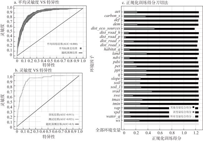
图3 林鸟分布区预测的模型精度及环境变量的重要性Fig. 3 Model accuracy and importance of environmental variables in predicting the distribution area of forest birds |
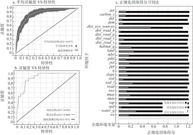
图4 水鸟分布区预测的模型精度及环境变量的重要性Fig. 4 Model accuracy and importance of environmental variables in predicting the distribution area of water birds |
图7 不同生境组团区之间的重要生态廊道及其空间分布Fig. 7 The important ecological corridors and their spatial distribution among different habitat groups |
表5 生态廊道长度与跨地市情况Table 5 Ecological corridor length and cross-city situation |
| 廊道编号 | 廊道长度/km | 途经地市 |
|---|---|---|
| HG1-HG3 | 123.00 | 南京、苏州、镇江、无锡、常州 |
| HG2-HG3 | 189.28 | 南京、苏州、镇江、无锡、常州、南通、泰州、扬州 |
| HG3-HG4 | 199.78 | 南京、苏州、镇江、无锡、常州、南通、泰州、扬州、盐城 |
| HG4-HG2 | 79.84 | 南通、盐城 |
| HG5-HG3 | 208.57 | 南京、苏州、镇江、无锡、常州、南通、泰州、扬州、淮安 |
| HG5-HG6 | 157.09 | 泰州、扬州、淮安、盐城 |
| HG6-HG3 | 257.36 | 南京、苏州、镇江、无锡、常州、南通、泰州、扬州、盐城 |
| HG6-HG4 | 101.84 | 盐城 |
| HG7-HG8 | 208.98 | 徐州、连云港 |
| HG8-HG5 | 189.03 | 连云港、宿迁、淮安、扬州 |
| HG8-HG6 | 209.55 | 盐城、连云港 |
| HG9-HG10 | 177.73 | 南京、苏州、镇江、无锡、常州 |
注:本文以100条LCPs的平均长度作为优化生态廊道的长度。 |
| [1] |
马克平. 《昆明—蒙特利尔全球生物多样性框架》是重要的全球生物多样性保护议程. 生物多样性, 2023, 31(4): 5-6.
[
|
| [2] |
|
| [3] |
王博宇, 闫慧敏, 胡云锋, 等. “半个地球”愿景下的保护地识别: 基于全球主要优先保护模块. 自然资源学报, 2021, 36(5): 1102-1115.
[
|
| [4] |
王伟, 李俊生. 中国生物多样性就地保护成效与展望. 生物多样性, 2021, 29(2): 133-149.
[
|
| [5] |
尹海伟, 孔繁花, 祈毅, 等. 湖南省城市群生态网络构建与优化. 生态学报, 2011, 31(10): 2863-2874.
[
|
| [6] |
马晓琳, 郭莎莎, 徐扬, 等. 生态脆弱区生态安全格局构建研究. 生态学报, 2023, 43(22): 9500-9513.
[
|
| [7] |
冯琳, 雷国平. 基于生态安全格局的东北典型黑土区生态保护红线划定与优化. 自然资源学报, 2024, 39(2): 426-445.
[
|
| [8] |
包玉斌, 黄涛, 王耀宗, 等. 基于生态重要性与敏感性的六盘山区生态保护修复分区. 干旱区地理, 2023, 46(11): 1778-1791.
[
|
| [9] |
林子雁, 肖燚, 史雪威, 等. 西南地区生态重要性格局研究. 生态学报, 2018, 38(24): 8667-8675.
[
|
| [10] |
刘泓君, 牛腾, 于强, 等. 基于“重要性—敏感性—景观特征”的黄土高原生态屏障带生态空间网络构建. 水土保持通报, 2022, 42(3): 103-111.
[
|
| [11] |
|
| [12] |
|
| [13] |
|
| [14] |
|
| [15] |
|
| [16] |
|
| [17] |
俞孔坚, 李迪华, 段铁武. 生物多样性保护的景观规划途径. 生物多样性, 1998, 6(3): 45-52.
[
|
| [18] |
|
| [19] |
|
| [20] |
|
| [21] |
|
| [22] |
|
| [23] |
|
| [24] |
|
| [25] |
傅强, 张海明, 张月蓉, 等. 面向生境保护与连通性维护的鄂温克族自治旗生态空间划定. 生态学报, 2024, 44(6): 2295-2307.
[
|
| [26] |
|
| [27] |
|
| [28] |
刘瑞程, 沈春竹, 贾振毅, 等. 道路景观胁迫下沿海滩涂地区生态网络构建与优化: 以盐城市大丰区为例. 生态学杂志, 2019, 38(3): 828-837.
[
|
| [29] |
李波, 贺萌, 彭琳, 等. 基于林鸟迁移扩散的重庆市高密度城区生态网络构建研究. 中国园林, 2023, 39(7): 35-39.
[
|
| [30] |
|
| [31] |
沈舟, 尹海伟, 孔繁花, 等. 基于生境组团化分析与景观廊道模拟的南京市白鹭生境网络构建与优化. 生态学报, 2024, 44(8): 3303-3316.
[
|
| [32] |
|
| [33] |
|
| [34] |
朱捷, 苏杰, 尹海伟, 等. 基于源地综合识别与多尺度嵌套的徐州生态网络构建. 自然资源学报, 2020, 35(8): 1986-2001.
[
|
| [35] |
|
| [36] |
|
| [37] |
|
| [38] |
|
| [39] |
岳文泽, 吴桐, 王田雨, 等. 面向国土空间规划的“双评价”: 挑战与应对. 自然资源学报, 2020, 35(10): 2299-2310.
[
|
/
| 〈 |
|
〉 |