
三峡库区“山—水—城”空间格局的生长模式与形成机理研究——以万州为例
|
王华(1991- ),男,湖南武冈人,博士,研究方向为城乡空间结构与国土空间规划。E-mail: zuoshou91@163.com |
收稿日期: 2023-11-06
修回日期: 2024-04-22
网络出版日期: 2024-07-10
基金资助
湖南省自然科学基金项目(2023JJ40444)
自然资源部南方丘陵区自然资源监测监管重点实验室开放基金重点项目(NRMSSHR2022Z10)
住房和城乡建设部软科学研究项目(2021-R-034)
国家自然科学基金项目(51678086)
The growth model and formation mechanism of "mountain-water-city" spatial pattern in the Three Gorges Reservoir Area: Take Wanzhou as an example
Received date: 2023-11-06
Revised date: 2024-04-22
Online published: 2024-07-10
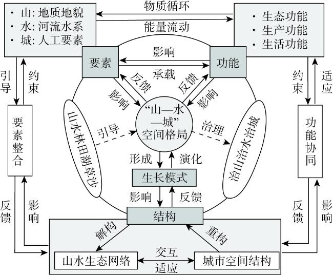
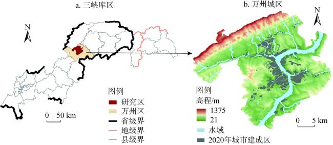
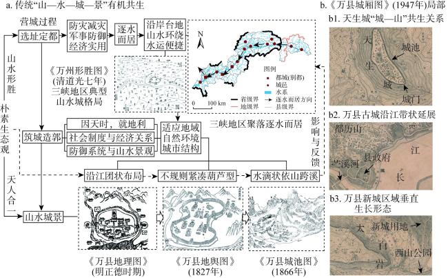
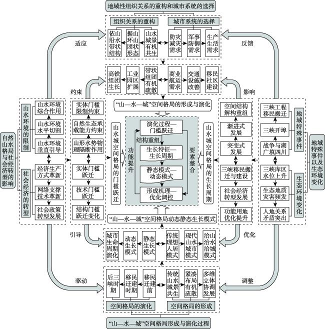
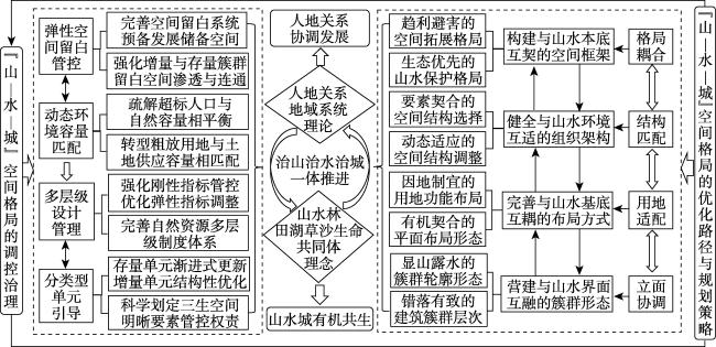
“山—水—城”空间格局是城市人工环境与自然山水环境交互适应所形成的空间组织关系。通过阐明“山—水—城”空间格局的概念内涵,从地理学视角建立其分析框架,选取典型城市万州为研究区,利用田野调查、地形位置指数模型、MCR模型等方法,综合研究三峡库区“山—水—城”空间格局的演化过程、生长模式、形成机理与优化调控。研究发现:(1)三峡库区“山—水—城”空间格局演化是一个“生成—强化—解构—重组”螺旋式上升的生长过程。在对外开埠与移民搬迁等因素的综合作用下,万州“山—水—城”空间格局的构成要素、结构形态与地域功能不断演化与重组。(2)三峡库区城市扩张对山水生态网络的影响与反馈,以及山水环境变化对城市空间生长的限制与引导,形成独特的“山—水—城”空间格局与生长模式,包括6种动态生长模式与12种静态生长模式。(3)地域性空间组织关系的重构以及城市系统的选择,决定“山—水—城”空间格局的形成与演化,受“自然山水环境+社会经济转型”“地域特殊事件+山水环境变化”的综合驱动,三峡库区城市空间生长逐渐突破实体门槛的限制,并向下一阶段生长周期持续演进。由此,提出库区“山—水—城”空间格局的调控路径,为治山、治水、治城一体推进与系统治理提供支撑。
关键词: “山—水—城”空间格局; 演化过程; 生长模式; 形成机理; 三峡库区
王华 , 方国臣 , 赵万民 , 周国华 . 三峡库区“山—水—城”空间格局的生长模式与形成机理研究——以万州为例[J]. 自然资源学报, 2024 , 39(7) : 1698 -1719 . DOI: 10.31497/zrzyxb.20240712
The spatial pattern of "mountain-water-city" is the spatial organization relationship formed by the interactive adaptation of urban artificial environment and natural landscape environment. By clarifying the conceptual connotation of the "mountain-water-city" spatial pattern, this paper establishes its analysis framework from the perspective of geography. Wanzhou, a typical city, is selected as the research area, and the evolution process, growth model, formation mechanism and optimization regulation of the "mountain-water-city" spatial pattern in the Three Gorges Reservoir Area (TGRA) are comprehensively studied by using field investigation, topographic position index and MCR model. Therefore, the research results are as follows: (1) The evolution of the "mountain-water-city" spatial pattern in the TGRA is a spiral upward cycle of "generation, strengthening, deconstruction and reorganization". The elements, structural forms and regional functions of the "mountain-water-city" spatial pattern in Wanzhou are constantly evolving and reorganizing under the comprehensive effect of the opening of the port to the outside world and the relocation of the Three Gorges Project. (2) The impact and feedback of urban expansion on landscape ecological network in the TGRA, as well as the restriction and guidance of landscape environment changes on urban spatial growth, formed a unique "mountain-water-city" spatial pattern and growth model, including 6 dynamic growth models and 12 static growth models. (3) The reconstruction of regional spatial organization relations and the selection of urban systems determine the formation and evolution of "mountain-water-city" spatial pattern. Driven by the comprehensive drive of "natural landscape environment+social and economic transformation" and "regional special events+landscape and environmental changes", the urban spatial growth in the TGRA gradually breaks through the physical threshold and continues to evolve in the next stage of growth cycle. Finally, this paper puts forward the regulation path of "mountain-water-city" spatial pattern in the TGRA, which provides support for the integrated promotion and systematic governance of mountain, water and city.
表1 地形位置指数分类因子指标表Table 1 TPI classification factor index table |
| 类型 | 分类因子 | ||
|---|---|---|---|
| TPI*(SD) | 坡度/(°) | 水域分布/m | |
| 山脊 | >1 | — | — |
| 陡坡 | 0.5~1 | — | — |
| 中坡 | -0.5~0.5 | 6~25 | — |
| 平坡 | -0.5~0.5 | <6 | — |
| 坡脚 | -1~ -0.5 | — | — |
| 沟谷 | < -1 | — | — |
| 水岸 | — | — | 0<S≤50 |
| 水域 | — | — | 距水域≤0 |
注:SD为TPI*数值的标准差,“—”表示无参数设置;S表示建设用地与江河岸线的空间距离(m)。 |
表2 三峡库区“山—水—城”空间格局的动态生长模式Table 2 Dynamic organizational model of "mountain-water-city" spatial pattern in the Three Gorges Reservoir Area |
| 类型 | 生长模式 | 生长模式特征 | 典型图示 |
|---|---|---|---|
| 水平切割 | 边缘线性 蔓延模式 | 新增城市建设用地一般位于沿江阶地与平坡地段,山地沟谷、河流水系成为限定城市空间扩展的生态边界,在河流岸线的引导作用下,城市用地边缘在适应沿江阶地形态的过程中,连续式或间断式生长出新的建筑簇群,多见于狭长河谷地带的旧城组团 | |
| 跃迁飞地 蛙跳模式 | 新增城市建设用地由于山地地形、河流水系的水平切割作用,或跨越河流水系,跃迁至适宜建设的地段,或突破山体地形的门槛限制,生长出诸多城市飞地,这种多个方向零散分布的“蛙跳式”空间生长模式,多见于工业开发区、高铁新城等新开发建设区,在后期将发展为连续成片的功能组团 | ||
| 见缝完形 内填模式 | 新增城市建设用地一般为城市内部未建设用地,由于库区移民新城建设的阶段性与时序性,原本地形相对复杂且尚未开发的区域,随着城市基础设施与公共服务设施的逐步完善,新增用地与建筑簇群以“见缝插针”的方式不断内填城市内部空间,形成形态相对完整的城市功能结构形态,多见于移民新城组团 | ||
| 垂直引导 | 边缘分散 蔓延模式 | 新增城市建设用地综合考虑坡度坡向、地质条件、水位变化等因素,沿道路或等高线呈带状延伸,充分占据原有建设用地周边的平坡、中坡等适宜建设用地地段,形成相对紧凑的团状或带状组团“山—水—城”空间格局 | |
| 越山飞地 蛙跳模式 | 新增城市建设用地与原有建设用地一般处于不同海拔高度,由于原有建设用地已占据周边适宜建设用地,城市空间逐渐突破山地地形的实体门槛限制,边缘邻接用地或越过陡坡堡坎向中坡地段扩展,或越过沟谷山脊向平坡地段扩展 | ||
| 外延层级 内填模式 | 新增城市建设用地被原有建设用地“包裹”或“半围合”,一般位于城市用地边缘的中坡、坡肩地段,由于开发时序及复杂地形的影响长期处于未开发状态,随着城市基础设施与公共服务设施的逐步完善,城市空间突破山地地形的限制,顺应坡面、山谷呈阶梯状层级布局,形成多维立体的“山—水—城”空间格局 |
| [1] |
萨娜, 赵金羽, 寇旭阳, 等. “山水林田湖草沙生命共同体”耦合框架、模型与展望. 生态学报, 2023, 43(11): 4333-4343.
[
|
| [2] |
方精云. 坚持治山治水治城一体推进. 人民日报, http://theory.people.com.cn, 2022-09-22.
[
|
| [3] |
樊杰, 王强, 周侃, 等. 我国山地城镇化空间组织模式初探. 城市规划, 2013, 37(5): 9-15.
[
|
| [4] |
王树声, 高元, 李小龙. 中国城市山水人文空间格局研究. 城市规划学刊, 2019, (1): 27-32.
[
|
| [5] |
杨保军, 王军. 山水人文智慧引领下的历史城市保护更新研究. 城市规划学刊, 2020, (2): 80-88.
[
|
| [6] |
钱学森. 社会主义中国应该建山水城市. 城市规划, 1993, (3): 19-18.
[
|
| [7] |
吴良镛. 桂林的城市模式与保护对象. 城市规划, 1988, (5): 3-8.
[
|
| [8] |
周干峙. 我对“山水城市”的认识. 城市发展研究, 2001, (2): 14-16.
[
|
| [9] |
吴良镛. “山水城市”与21世纪中国城市发展纵横谈: 为山水城市讨论会写. 建筑学报, 1993, (6): 4-8.
[
|
| [10] |
王树声. 中国城市山水风景“基因”及其现代传承: 以古都西安为例. 城市发展研究, 2016, 23(12): 1-4, 28.
[
|
| [11] |
陈宇琳. 基于“山—水—城”理念的历史文化环境保护发展模式探索. 城市规划, 2009, 33(11): 58-64.
[
|
| [12] |
郑曦. 山水都市化:区域景观系统上的城市. 北京: 中国建筑工业出版社, 2018.
[
|
| [13] |
鲍世行, 顾孟潮. 杰出科学家钱学森论城市学与山水城市. 北京: 中国建筑工业出版社, 2010.
[
|
| [14] |
|
| [15] |
|
| [16] |
|
| [17] |
赵万民. 山地人居环境七论. 北京: 中国建筑工业出版社, 2015.
[
|
| [18] |
沈镭, 钟帅, 胡纾寒. 新时代中国自然资源研究的机遇与挑战. 自然资源学报, 2020, 35(8): 1773-1788.
[
|
| [19] |
张杨, 杨洋, 江平, 等. 山水林田湖草生命共同体的科学认知、路径及制度体系保障. 自然资源学报, 2022, 37(11): 3005-3018.
[
|
| [20] |
段进, 邵润青, 兰文龙, 等. 空间基因. 城市规划, 2019, 43(2): 14-21.
[
|
| [21] |
王华. 三峡库区城镇空间形态的山水环境适应性研究. 重庆: 重庆大学, 2021.
[
|
| [22] |
吴良镛, 赵万民. 三峡工程与人居环境建设. 城市规划, 1995, 19(4): 5-10.
[
|
| [23] |
赵万民. 三峡库区人居环境建设发展研究:理论与实践. 北京: 中国建筑工业出版社, 2015.
[
|
| [24] |
李远, 王万鸿, 赵宇, 等. 三峡库区万州热岛演变与城市形态关系. 西南大学学报: 自然科学版, 2017, 39(5): 190-196.
[
|
| [25] |
王华, 赵万民, 周国华. 三峡库区城市空间生长的演进过程与动力机制研究. 地理研究, 2023, 42(3): 660-681.
[
|
| [26] |
王华, 周国华, 赵万民, 等. “山—水—城”空间格局的分析框架与研究展望. 地理学报, 2024, 79(6): 1478-1502.
[
|
| [27] |
樊杰. 人地系统可持续过程、格局的前沿探索. 地理学报, 2014, 69(8): 1060-1068.
[
|
| [28] |
龙花楼, 屠爽爽. 论乡村重构. 地理学报, 2017, 72(4): 563-576.
[
|
| [29] |
吴传钧. 论地理学的研究核心: 人地关系地域系统. 经济地理, 1991, 11(3): 1-6.
[
|
| [30] |
陆大道, 姚士谋, 李国平, 等. 基于我国国情的城镇化过程综合分析. 经济地理, 2007, 27(6): 883-887.
[
|
| [31] |
傅伯杰. 地理学综合研究的途径与方法: 格局与过程耦合. 地理学报, 2014, 69(8): 1052-1059.
[
|
| [32] |
樊杰. “人地关系地域系统”是综合研究地理格局形成与演变规律的理论基石. 地理学报, 2018, 73(4): 597-607.
[
|
| [33] |
蓝勇. 长江三峡历史地图集. 北京: 星球地图出版社, 2015.
[
|
| [34] |
李林昉, 雷昌德. 老重庆影像志:老地图. 重庆: 重庆出版集团重庆出版社, 2013.
[
|
| [35] |
方国臣. 三峡库区“山—水—城”空间形态协同发展研究: 以万州、云阳中心城区为例. 重庆: 重庆大学, 2021.
[
|
| [36] |
张璨, 方世明. 山水资源型城镇的生态安全格局构建研究: 以武汉市黄陂区为例. 长江流域资源与环境, 2020, 29(8): 1835-1845.
[
|
| [37] |
田瑞云, 王玉宽, 傅斌, 等. 基于DEM的地形单元多样性指数及其算法. 地理科学进展, 2013, 32(1): 121-129.
[
|
| [38] |
|
| [39] |
高金龙, 陈江龙, 袁丰, 等. 南京市区建设用地扩张模式、功能演化与机理. 地理研究, 2014, 33(10): 1892-1907.
[
|
| [40] |
明吴潜, 傅汝舟. 正德夔州府志. 北京: 中华书局, 2009.
[
|
| [41] |
张琴修, 范泰衡. 万县志. 台北: 成文出版社, 1976.
|
| [42] |
恩成修, 刘德荃. 道光夔州府志. 成都: 巴蜀书社, 2017.
[
|
| [43] |
万县城厢图, http://www.txlzp.com/ditu/1571.html, 2021-12-02.
[City map of Wanxian county, http://www.txlzp.com/ditu/1571.html, 2021-12-02.]
|
| [44] |
重庆市万州区三峡移民志编纂委员会. 万州三峡移民志. 北京: 中国三峡出版社, 2014.
[The Three Gorges Immigration Compilation Committee in Wanzhou, Chongqing. Annals of Migration for Three Gorges Reservoir Area in Wanzhou. Beijing: China Three Gorges Press, 2014.]
|
| [45] |
王松涛, 祝莹. 三峡库区城镇形态的演变与迁建. 城市规划汇刊, 2000, (2): 68-74, 80.
[
|
| [46] |
唐燕, 郭磊贤. 基于坡度分析的丘陵城市形态设计策略研究. 现代城市研究, 2015, (6): 85-92.
[
|
| [47] |
张雪原, 翟国方. 山地城市空间形态生长特征分析. 现代城市研究, 2013, 28(2): 45-50, 56.
[
|
/
| 〈 |
|
〉 |


