
基于人工智能和遥感技术的城市更新单元识别方法研究及应用
|
白婷(1992-),女,湖北随州人,博士,研究方向为深度学习、变化检测。E-mail: baiting@whu.edu.cn |
收稿日期: 2022-08-08
修回日期: 2023-04-07
网络出版日期: 2023-06-09
基金资助
国家重点研发计划项目(2022YFB3902900)
国家自然科学基金项目(42192583)
Research and application of urban renewal unit recognition method based on AI and remote sensing
Received date: 2022-08-08
Revised date: 2023-04-07
Online published: 2023-06-09
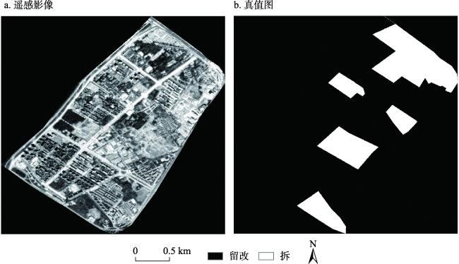
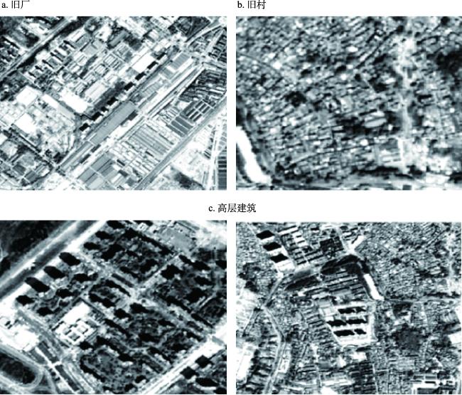
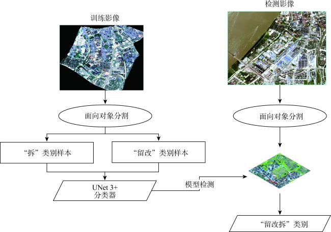
当前武汉市城市更新行动,从大拆大建,进入“留改拆”并举的2.0时代,改造方式也从局部改造向成片连片更新转变。在当前2.0时代中,如何利用人工智能(Artificial Intelligence,AI)技术智能识别出城市“留改拆”单元显得尤为重要。当前AI和遥感技术已在自然资源典型地物类型识别、耕地保护和执法监察中得到广泛应用,本文第一次将AI和遥感技术用于“留改拆”单元的智能识别中,以辅助智能化城市更新行动。建立“留改拆”单元的样本,利用深度学习网络建立AI+遥感技术的智能化识别模型,选择遥感数据,进行武汉市更新片区“留改拆”单元智能化识别。通过遥感技术与深度学习算法的融合,提升了城市更新行动中“留改拆”单元识别的工作效率,为城市更新行动中的难点问题提供了科学依据。
白婷 , 邓实权 , 熊花 , 孙开敏 , 李王斌 , 刘俊怡 . 基于人工智能和遥感技术的城市更新单元识别方法研究及应用[J]. 自然资源学报, 2023 , 38(6) : 1517 -1531 . DOI: 10.31497/zrzyxb.20230609
At present, the urban renewal action of Wuhan has changed from large-scale demolition and construction to the era of "retaining, replacing and dismantling". The transformation mode has also changed from local transformation to continuous renewal. In the current era, it is particularly important to identify urban "retained, replaced and demolished" units intelligently. Recently, the combination of AI and remote sensing has been widely used for the identification of typical surface features of natural resources, cultivated land protection, and law enforcement supervision. In this paper, we combine AI and remote sensing to identify "retention, reconstruction and demolition" units. First, we establish training samples of the "retention, replacement and demolition" unit, then use the deep learning network to establish the artificial intelligent model, and finally select the remote sensing data to carry out the identification of "retention, replacement and demolition" unit in Wuhan. The integration of remote sensing and deep learning improves work efficiency of the identification of "retaining, replacing and dismantling" units, and provides scientific basis for solving the pain points in urban renewal.
Key words: AI; remote sensing; deep learning; urban renewal
表1 数据集2的精度检测结果Table 1 The accuracy results of dataset 2 |
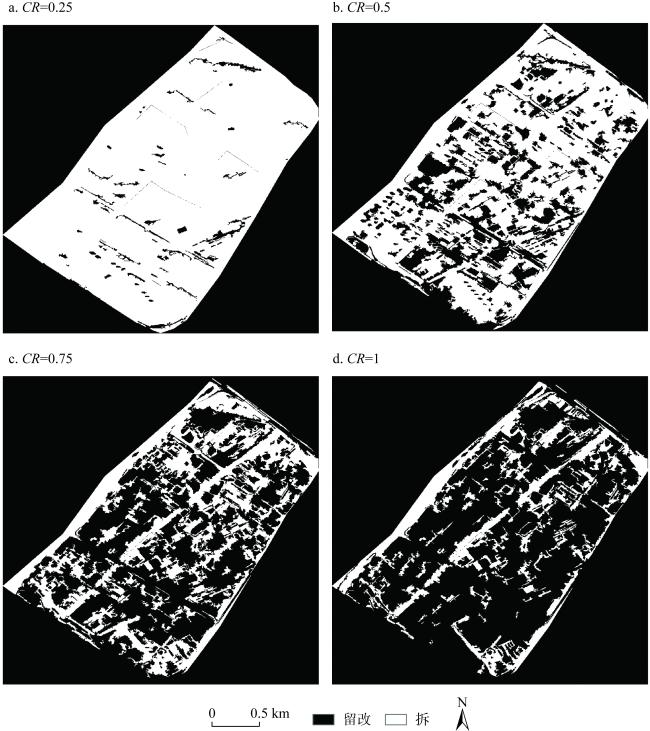
| 拆迁率 | 总体精度/% | 拆漏检率/% | 拆错检率/% | 留改漏检率/% | 留改错检率/% |
|---|---|---|---|---|---|
| 0.25 | 84.80 | 1.30 | 29.90 | 22.69 | 0.90 |
| 0.50 | 83.59 | 14.43 | 27.49 | 17.48 | 8.61 |
| 0.75 | 77.16 | 44.38 | 27.26 | 11.23 | 21.22 |
| 1.00 | 73.03 | 62.97 | 27.52 | 7.58 | 26.86 |
表2 数据集3的精度检测结果Table 2 The accuracy results of dataset 3 |
| 拆迁率 | 总体精度/% | 拆漏检率/% | 拆错检率/% | 留改漏检率/% | 留改错检率/% |
|---|---|---|---|---|---|
| 0.25 | 62.90 | 2.80 | 75.49 | 41.90 | 0.67 |
| 0.50 | 70.59 | 24.67 | 74.04 | 30.08 | 4.71 |
| 0.75 | 77.98 | 53.56 | 73.04 | 17.61 | 8.34 |
| 1.00 | 81.01 | 73.70 | 75.47 | 11.33 | 10.42 |
| [1] |
|
| [2] |
周翔. 武汉市主城区城市更新单元划定方法及更新策略研究. 武汉: 华中科技大学, 2020.
[
|
| [3] |
中华人民共和国国民经济和社会发展第十四个五年规划和2035年远景目标纲要. http://www.gov.cn/xinwen/2021-03/13/content_5592681.htm, 2021.
[The 14th Five-Year Plan for National Economic and Social Development of the People's Republic of China and Outline of the Vision for 2035. http://www.gov.cn/xinwen/2021-03/13/content_5592681.htm, 2021.]
|
| [4] |
张弓. 城市更新的低碳实施策略: 从“拆改留”到“留改拆”. 可持续发展经济导刊, 2022, (4): 22-23.
[
|
| [5] |
国务院关于印发2030年前碳达峰行动方案的通知. http://www.gov.cn/zhengce/content/2021-10/26/content_5644984.htm?trs=1, 2021.
[Notice of the State Council on Printing and Distributing the Action Plan for Carbon Peaking Before 2030. http://www.gov.cn/zhengce/content/2021-10/26/content_5644984.htm?trs=1, 2021.]
|
| [6] |
住房和城乡建设部关于在实施城市更新行动中防止大拆大建问题的通知. http://www.gov.cn/zhengce/zhengceku/2021-08/31/content_5634560.htm, 2021.
[Notice of the Ministry of Housing and Urban-Rural Development on Preventing Large-scale Demolition and Construction in the Implementation of Urban Renewal Actions. http://www.gov.cn/zhengce/zhengceku/2021-08/31/content_5634560.htm, 2021.]
|
| [7] |
对市政协十三届五次会议第20210209号提案的答复. http://zrzyhgh.wuhan.gov.cn/zwgk_18/fdzdgk/jytabl/sjjyta/202110/t20211013_1794282.shtm, 2021.
[Reply to Proposal No. 20210209 of the Fifth Session of the Thirteenth CPPCC. http://zrzyhgh.wuhan.gov.cn/zwgk_18/fdzdgk/jytabl/sjjyta/202110/t20211013_1794282.shtml, 2021.]
|
| [8] |
龙运涛, 古杰. 基于潜力和建筑质量评价的城中村更新研究: 以益阳市康富北路片区为例. 城市学刊, 2022, 43(2): 59-64.
[
|
| [9] |
周建梁. 城市更新方式的多样性研究. 上海房地, 2019, (2): 9-11.
[
|
| [10] |
孙畅, 古杰. 保护·传承·复兴: 历史文化街区的城市设计思路: 以台州市十里长街为例. 城市学刊, 2020, 41(5): 58-63.
[
|
| [11] |
张晓琳, 金晓斌, 范业婷, 等. 1995—2015年江苏省土地利用功能转型特征及其协调性分析. 自然资源学报, 2019, 34(4): 689-706.
[
|
| [12] |
王瑷玲, 张校千, 苏晨晨, 等. OBIA与RF结合的龙口市土地利用信息提取方法. 自然资源学报, 2019, 34(4): 707-717.
[
|
| [13] |
李亮, 舒宁, 龚龑. 考虑时空关系的遥感影像变化检测和变化类型识别. 武汉大学学报: 信息科学版, 2013, 38(5): 533-537.
[
|
| [14] |
高熔溶. 基于图割模型和深度学习的高分辩率遥感影像地物要素提取. 武汉: 武汉大学, 2017.
[
|
| [15] |
高贤君, 冉树浩, 张广斌, 等. 基于多特征融合与对象边界联合约束网络的建筑物提取. 武汉大学学报: 信息科学版, 1-19[2023-06-05]. https://doi.org/10.13203/j.whugis20210520.
[
|
| [16] |
刘秋平. 浅谈基于深度学习的自动化视觉道路要素提取技术在自动驾驶中的应用. 中国北斗应用大会暨中国卫星导航与位置服务第九届年会, 中国湖北武汉, 2020.
[
|
| [17] |
宋玉莲. 基于多源数据融合的城市核心要素提取及时空变化分析. 吉林: 吉林大学, 2022.
[
|
| [18] |
张涛, 方宏, 韦玉春, 等. 顾及空间自相关性的高分遥感影像中建设用地的变化检测. 自然资源学报, 2020, 35(4): 963-976.
[
|
| [19] |
|
| [20] |
樊舒迪. 基于遥感与开放数据的广州市白云区城镇低效建设用地识别. 广州: 华南农业大学, 2019.
[
|
| [21] |
冯东东, 张志华, 石浩月. 基于多元数据的省会城市城中村精细提取. 自然资源遥感, 2021, 33(3): 272-278.
[
|
| [22] |
|
| [23] |
|
| [24] |
|
| [25] |
|
| [26] |
|
| [27] |
李雨慧. 基于深度学习的高分辨率遥感影像多尺度语义分割. 上海: 上海交通大学, 2018.
[
|
| [28] |
牛子儒. 基于深度学习的高分辨率遥感影像语义分割研究. 郑州: 郑州大学, 2021.
[
|
| [29] |
|
| [30] |
|
| [31] |
徐俊峰, 张保明, 郭海涛, 等. 一种多特征融合的面向对象多源遥感影像变化检测方法. 测绘科学技术学报, 2015, 32(5): 505-509.
[
|
| [32] |
范鑫, 胡昌苗, 霍连志. 耦合多源地理数据的多分辨率遥感影像场景分类方法研究. 无线电工程, 2021, 51(12): 1449-1460.
[
|
| [33] |
王一鸣. 城市更新过程中多元利益相关者冲突机理与协调机制研究. 重庆: 重庆大学, 2019.
[
|
| [34] |
|
| [35] |
|
| [36] |
|
/
| 〈 |
|
〉 |


