
空间治理视角下的城市建成区土地混合利用功能与结构
|
王开家(1997-),女,浙江温州人,硕士,研究方向为国土空间规划、城市土地混合利用。E-mail: 492714672@qq.com |
收稿日期: 2022-08-08
修回日期: 2022-12-02
网络出版日期: 2023-06-09
基金资助
中国科学院战略性先导科技专项(A类)(XDA23100502)
国家重点研发计划(2017YFB0503505-6)
福建省科技厅引导性项目(2022H0009)
A study on the function and structure of mixed land use in urban built-up areas from the perspective of spatial governance
Received date: 2022-08-08
Revised date: 2022-12-02
Online published: 2023-06-09
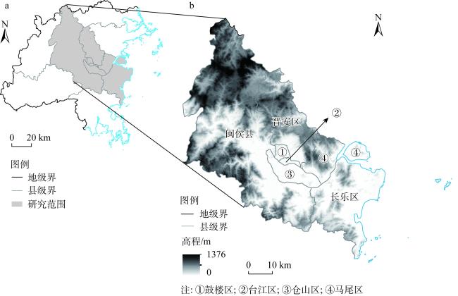
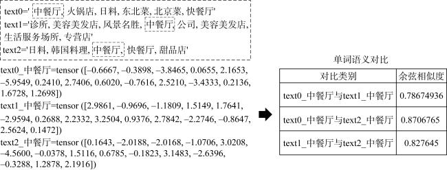
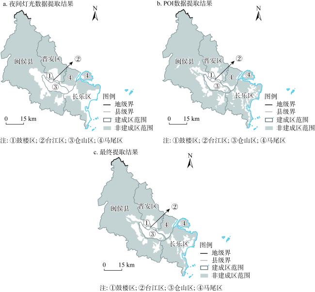
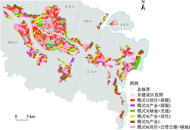
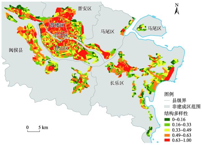
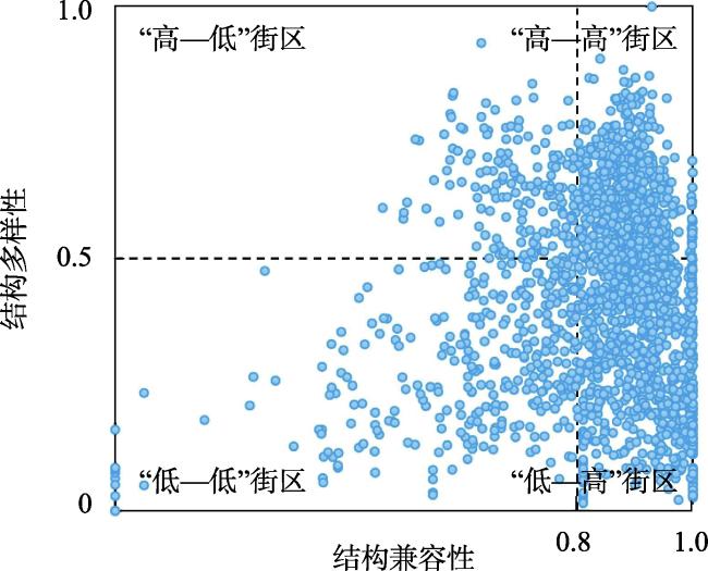
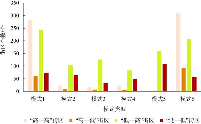
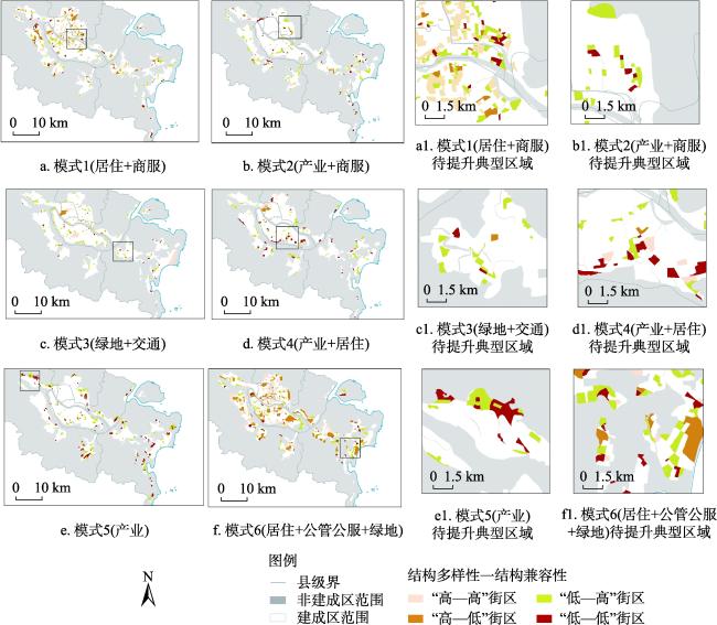
城市建成区土地混合利用对促进城市用地集约利用、提升国土空间治理水平具有重要意义。以福州市七个区县为研究区,利用多源数据提取福州建成区范围;在街区尺度下,基于POI数据与自然语言处理技术(BERT模型),构建一种顾及城市混合功能语义的混合模式提取方法(MixedFunc2Vec),并从土地利用混合功能与结构两大维度开展城市建成区土地混合利用研究。结果表明:(1)MixedFunc2Vec方法解决了传统城市功能语义提取中存在的“一词多义”问题,能够捕捉更加丰富的POI语义信息,并提取得到六大类混合功能模式;(2)福州市建成区内,模式6(居住+公管公服+绿地)内部的土地利用结构多样性最为丰富,而以各类产业为主导的模式5则处于最低的多样性水平,建成区内呈现多地多中心集聚式发展态势;(3)在结构兼容性方面,建成区内兼容性指数达到0.7以上的街区约有1803个,模式1(居住+商服)与模式6(居住+公管公服+绿地)的平均兼容性指数均为0.8525,除此之外,以产业功能为主导的区域及其周边区域,其混合兼容性水平仍有提升空间;(4)综合结构多样性与兼容性的测度结果,福州市建成区内各街区可划分得到“高—高”街区、“高—低”街区、“低—高”街区与“低—低”街区等四类街区,并提出了基于不同混合功能模式的空间差异化街区调整建议。本文可为丰富现有土地混合利用理论与方法体系、城市空间格局优化及国土空间规划政策制定提供一定科学依据。
王开家 , 徐伟铭 , 李楚瑜 , 邵尔辉 , 杨慧 . 空间治理视角下的城市建成区土地混合利用功能与结构[J]. 自然资源学报, 2023 , 38(6) : 1496 -1516 . DOI: 10.31497/zrzyxb.20230608
Mixed land use in urban built-up areas is important for promoting intensive use of urban land and improving the level of land spatial governance. This paper takes seven districts and counties in Fuzhou as the study area and uses multi-source data to extract the built-up area of this city. Based on POI data and natural language processing technology (BERT model), a mixed pattern extraction method (MixedFunc2Vec) that takes into account the semantics of urban mixed functions is constructed at the block scale, and the study of mixed land use in urban built-up areas is carried out from two dimensions of mixed functions and structures of land use. The results show that: (1) MixedFunc2Vec method solves the problem of "multiple meanings of words" in traditional city function semantic extraction, captures richer semantic information of POI, and extracts six types of mixed function patterns. (2) In the built-up area of Fuzhou, mode 6 (residential + public services + green space) has the richest land use structural diversity, while mode 5, which is dominated by various industries, is at the lowest diversity level and shows a cluster development trend of multi-location and multi-center. (3) In terms of structural compatibility, there are about 1803 blocks in the built-up area with a compatibility index of 0.7 or more. The average compatibility index of mode 1 (residential + commercial services) and mode 6 (residential + public services + green space) are both 0.8525, except for the industrial function-oriented areas and their surrounding areas, which still have room for improvement. (4) Based on the measurement results of structural diversity and compatibility, the blocks in the built-up area of Fuzhou can be divided into four types, including high-high, high-low, low-high, and low-low patterns, and suggestions are made to adjust the blocks based on different mixed functional patterns. This study can provide some scientific basis for enriching the existing theoretical and methodological system of mixed land use, urban spatial pattern optimization and territorial spatial planning policy formulation.
Key words: POI; urban built-up area; mixed land use; BERT model; Fuzhou city
表1 POI数据与用地类型对照表Table 1 Comparison of POI data and land use type |
| POI大类 | 用地类型 | 影响度(面积) | |
|---|---|---|---|
| 商服用地 | 餐饮服务 | 餐饮用地 | 10 |
| 购物服务 | 零售商业用地 | 15 | |
| 金融保险服务 | 商务金融用地 | 30 | |
| 生活服务 | 其他商服用地 | 10 | |
| 体育休闲服务 | 娱乐康体用地 | 10 | |
| 住宿服务 | 旅馆用地 | 10 | |
| 公共管理与公共服务用地 | 政府机构及社会团体 | 机关团体用地 | 30 |
| 科教文化服务 | 科教文化用地 | 30 | |
| 医疗保健服务 | 医疗卫生用地 | 20 | |
| 一类工业用地 | 公司企业 | 一类工业用地用地 | 30 |
| 二三类工业用地 | 工厂及产业园 | 二三类工业用地 | 70 |
| 物流仓储用地 | 物流仓储场地 | 物流仓储用地 | 30 |
| 农林牧渔用地 | 农林牧渔基地 | 农林牧渔用地 | 60 |
| 交通运输用地 | 交通设施服务 | 交通设施用地 | 15 |
| 居住用地 | 商务住宅 | 居住用地 | 50 |
| 绿地 | 公园绿地 | 公园与绿地 | 95 |
| 风景名胜 | 风景名胜设施用地 | 95 |
表2 各用地兼容性一览表[14]Table 2 The compatibility list of land use |
| 商服用地 | 公共管理与公共服务用地 | 居住用地 | 一类工业用地 | 二三类工业用地 | 物流仓储用地 | 绿地 | 交通运输用地 | 农林牧渔用地 | |
|---|---|---|---|---|---|---|---|---|---|
| 商服用地 | 0 | 0.03 | 0 | 0.19 | 0.95 | 0.08 | 0 | 0 | 0.05 |
| 公共管理与公共服务用地 | 0.03 | 0 | 0 | 0.55 | 0.98 | 0.53 | 0 | 0 | 0 |
| 居住用地 | 0 | 0 | 0 | 0.45 | 0.99 | 0.45 | 0 | 0 | 0 |
| 一类工业用地 | 0.19 | 0.55 | 0.45 | 0 | 0.06 | 0.01 | 0.45 | 0 | 0.08 |
| 二三类工业用地 | 0.95 | 0.98 | 0.99 | 0.06 | 0 | 0.06 | 0.75 | 0 | 0.64 |
| 物流仓储用地 | 0.08 | 0.53 | 0.45 | 0.01 | 0.06 | 0 | 0.45 | 0 | 0.1 |
| 绿地 | 0 | 0 | 0 | 0.45 | 0.75 | 0.45 | 0 | 0 | 0.03 |
| 交通运输用地 | 0 | 0 | 0 | 0 | 0 | 0 | 0 | 0 | 0 |
| 农林牧渔用地 | 0.05 | 0 | 0 | 0.08 | 0.64 | 0.1 | 0.03 | 0 | 0 |
表4 混合功能模式向量相似度对比Table 4 Comparison of vector similarity of mixed function mode |
| 模式1 (居住+商服) | 模式2 (产业+商服) | 模式3 (绿地+交通) | 模式4 (产业+居住) | 模式5 (产业) | 模式6 (居住+公管公服+绿地) | 街区数量/个 | |
|---|---|---|---|---|---|---|---|
| 模式1 (居住+商服) | 1 | 0.9189 | 0.7936 | 0.8484 | 0.6598 | 0.9188 | 799 |
| 模式2 (产业+商服) | 0.9189 | 1 | 0.7962 | 0.9221 | 0.9291 | 0.8051 | 239 |
| 模式3 (绿地+交通) | 0.7936 | 0.7962 | 1 | 0.8818 | 0.7601 | 0.7961 | 203 |
| 模式4 (产业+居住) | 0.8484 | 0.9221 | 0.8818 | 1 | 0.9492 | 0.9218 | 182 |
| 模式5 (产业) | 0.6598 | 0.9291 | 0.7601 | 0.9492 | 1 | 0.8047 | 235 |
| 模式6 (居住+公管公服+绿地) | 0.9188 | 0.8051 | 0.7961 | 0.9218 | 0.8047 | 1 | 475 |
| [1] |
|
| [2] |
秦萧, 甄峰. 基于要素流动的城镇建设用地配置方法框架探讨. 自然资源学报, 2022, 37(11): 2774-2788.
[
|
| [3] |
刘润佳, 把多勋. 中国省会城市紧凑度与城镇化水平关系. 自然资源学报, 2020, 35(3): 586-600.
[
|
| [4] |
郑红玉, 黄建洪, 卓跃飞, 等. 土地混合利用测度研究进展. 中国土地科学, 2019, 33(3): 95-104.
[
|
| [5] |
|
| [6] |
韩昊英, 于翔, 龙瀛. 基于北京公交刷卡数据和兴趣点的功能区识别. 城市规划, 2016, 40(6): 52-60.
[
|
| [7] |
陈世莉, 陶海燕, 李旭亮, 等. 基于潜在语义信息的城市功能区识别: 广州市浮动车GPS时空数据挖掘. 地理学报, 2016, 71(3): 471-483.
[
|
| [8] |
|
| [9] |
刘菁菁, 刘雨思, 伊迪升, 等. 北京市四环内街区尺度下的主题混合模式挖掘. 地球信息科学学报, 2020, 22(6): 1370-1382.
[
|
| [10] |
|
| [11] |
|
| [12] |
|
| [13] |
张佰林, 钱家乘, 蔡为民. 论农村居民点用地混合利用的研究框架. 自然资源学报, 2020, 35(12): 2929-2941.
[
|
| [14] |
师浩辰, 赵渺希, 陈佩谦. 土地混合使用视角下的地块间兼容度测度: 以湖南省湘潭市市辖区为例. 热带地理, 2021, 41(4): 746-759.
[
|
| [15] |
张佰林, 王昭颖, 朱敏杰. 农村居民点用地混合利用特征及驱动力. 农业工程学报, 2022, 38(3): 267-275.
[
|
| [16] |
周德, 钟文钰, 周婷, 等. 基于POI数据的城市土地混合利用评价及影响因素分析: 以杭州市主城区为例. 中国土地科学, 2021, 35(8): 96-106.
[
|
| [17] |
李建春, 起晓星, 袁文华. 基于POI数据的建设用地多功能混合利用空间分异研究. 地理科学进展, 2022, 41(2): 239-250.
[
|
| [18] |
张扬, 郑凤娇, 刘艳芳, 等. 基于POI与不透水表面指数的城市建成区提取. 地理科学, 2022, 42(3): 506-514.
[
|
| [19] |
郑洪晗, 桂志鹏, 栗法, 等. 夜间灯光数据和兴趣点数据结合的建成区提取方法. 地理与地理信息科学, 2019, 35(2): 25-32.
[
|
| [20] |
|
| [21] |
曹芳洁, 邱芸, 邹艳. 基于H/T断裂法与POI数据的建成区快速提取方法. 地理与地理信息科学, 2020, 36(6): 48-54.
[
|
| [22] |
王方民, 骆畅, 杨朝现, 等. 基于兴趣点密度与城市扩张曲线的城市建成区边界识别. 西南大学学报: 自然科学版, 2021, 43(12): 115-126.
[
|
| [23] |
厉飞, 闫庆武, 邹雅婧, 等. 利用夜间灯光POI的城市建成区提取精度研究: 以珞珈一号01星和NPP/VIIRS夜间灯光影像为例. 武汉大学学报: 信息科学版, 2021, 46(6): 825-835.
[
|
| [24] |
许泽宁, 高晓路. 基于电子地图兴趣点的城市建成区边界识别方法. 地理学报, 2016, 71(6): 928-939.
[
|
| [25] |
|
| [26] |
张春雷. 基于嵌入表示的知识图谱实体对齐研究. 长春: 吉林大学, 2022.
[
|
| [27] |
|
| [28] |
曹根榕, 顾朝林, 张乔扬. 基于POI数据的中心城区“三生空间”识别及格局分析: 以上海市中心城区为例. 城市规划学刊, 2019, (2): 44-53.
[
|
| [29] |
|
| [30] |
|
/
| 〈 |
|
〉 |


