
青藏高原高山峡谷区建设用地和耕地适宜性评价方法及应用——以林芝市为例
|
杨华(1995- ),男,四川达州人,博士研究生,主要从事土地利用与人地关系机理模拟、资源环境承载力评价等研究。E-mail: 1451832197@qq.com |
收稿日期: 2022-03-07
修回日期: 2022-06-08
网络出版日期: 2023-05-15
基金资助
第二次青藏高原综合科学考察研究(2019QZKK0406)
国家重点研发计划项目(2018YFD1100101)
Evaluation method and empirical application of construction land suitability and arable land suitability in alpine-gorge region of Qinghai-Tibet Plateau: A case study of Nyingchi city
Received date: 2022-03-07
Revised date: 2022-06-08
Online published: 2023-05-15
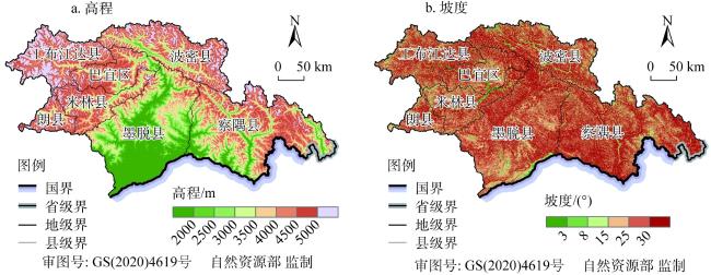
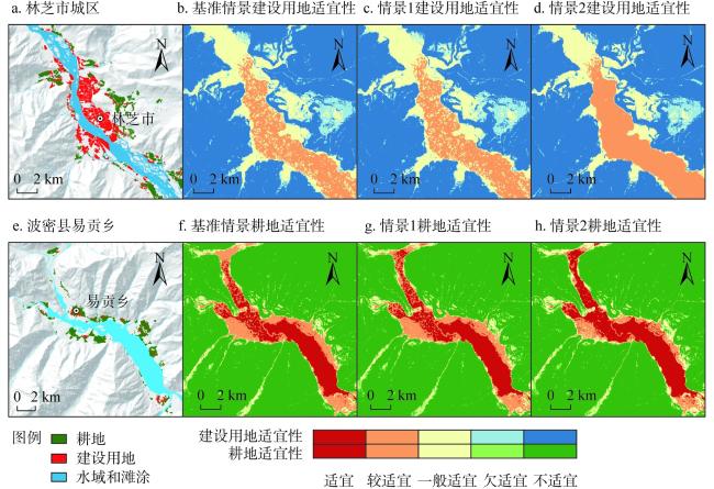
青藏高原是中国乃至亚洲的重要生态屏障区,进行建设用地和耕地适宜性评价对于青藏高原生态保护、严格人类活动空间具有重要意义。针对中国现行建设用地和耕地适宜性评价方法在高海拔地区应用中存在的不足,分别构建了适用于青藏高原高山峡谷区的建设用地和耕地适宜性评价模型,提出了空气密度、坡地适建、气温和土壤抗蚀四个控制参数测算方法;以100 m间隔高程分级和1°间隔坡度分级为基准情景,选择林芝市为典型案例开展实证应用研究,并对两种增大高程和坡度间隔分级情景进行论证。结果表明:(1)林芝市建设用地和耕地适宜性均以不适宜为主体,不适宜区面积占土地总面积比例分别为87.48%和87.42%,欠适宜区比例分别为5.58%和4.58%,适宜、较适宜和一般适宜区的面积之和占比分别仅为6.94%、7.60%;(2)基准情景下建设用地和耕地适宜性评价结果与现状建设用地和耕地的适配效果较好,适配精度分别达到93.59%和90.89%,米林县、巴宜区和波密县的适配精度达到95%以上;(3)情景1和情景2下建设用地适宜性的适配精度与基准情景的误差分别为-0.48%和-2.31%,耕地适宜性的适配精度与基准情景的误差分别为+0.63%和+0.65%,误差处于可接受范围;(4)500 m高程间隔和3°、5°、8°、12°、15°、20°、25°的坡度间隔适用于青藏高原高山峡谷区建设用地和耕地适宜性评价。
杨华 , 徐勇 , 王丽佳 . 青藏高原高山峡谷区建设用地和耕地适宜性评价方法及应用——以林芝市为例[J]. 自然资源学报, 2023 , 38(5) : 1283 -1299 . DOI: 10.31497/zrzyxb.20230511
The Qinghai-Tibet Plateau is an important ecological barrier area in China and Asia.Conducting construction land suitability evaluation (CLSE) and arable land suitability evaluation (ALSE) is important for ecological protection, restriction of human activity space in this plateau. However, the application has the defects of existing CLSE and ALSE models and methods in high-altitude areas. In this paper, we constructed CLSE and ALSE models applicable to alpine-gorge region in the Qinghai-Tibet Plateau, as well as proposed the measurement methods of four control parameters: air density, sloping land suitability for construction, air temperature and soil erosion resistance of sloping land. Based on the standard scenarios of elevation-slope classification with an interval of 100 m in elevation and 1° in slope, an empirical application research was carried out in Nyingchi city, the typical area of alpine-gorge region in the Qinghai-Tibet Plateau, and the feasibility was demonstrated of two different elevation-slope classification scenarios for CLSE and ALSE as well. This article obtains four conclusions: (1) Construction land suitability (CLS) and arable land suitability (ALS) in Nyingchi city can be divided into five grade types: suitable, relatively suitable, moderately suitable, less suitable, and unsuitable. The grade type of CLS and ALS is mainly unsuitable in the city, with 87.48% and 87.42% area ratio of unsuitable grade type, 5.58% and 4.58% area ratio of less suitable grade type, and sum area ratio of suitable, relatively suitable, moderately suitable grade types accounted for only 6.94% and 7.60%. (2) The matching degree is high of CLS and ALS with current construction land and arable land under standard scenario in Nyingchi city, with the matching accuracy reaching 93.59% and 90.89%, respectively, among which the matching accuracy in Mainling county, Chagyib district, and Bowo county is above 95%, and the matching accuracy in Gongbo' gyada county, Nang county, and Mêdog county is very low, respectively. (3) The matching accuracy is 93.11% and 91.28% of CLS under scenarios 1 and 2, and its matching error is -0.48% and -2.31% with the standard scenario. The matching accuracy is 91.52% and 91.54% of ALS under scenarios 1 and 2, and its matching error is +0.63% and +0.65% with the standard scenario. The model error is within an acceptable range. (4) Classification schemes with an interval of 500 m in elevation and 3°, 5°, 8°, 12°, 15°, 20°, and 25° in slope are applicable for CLSE and ALSE in alpine-gorge region of the Qinghai-Tibet Plateau.
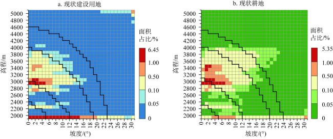
表1 对照平地的不同坡度下坡地实际建设用地面积数据Table 1 Actual construction land area of sloping land under different slopes compared with flat land |
| 坡度/(°) | 实际建设用地面积/hm2 | 坡度/(°) | 实际建设用地面积/hm2 | 坡度/(°) | 实际建设用地面积/hm2 |
|---|---|---|---|---|---|
| 0 | 1.0000 | 15 | 0.7906 | 30 | 0.4701 |
| 1.5 | 0.9827 | 17.5 | 0.7466 | 32.5 | 0.4003 |
| 3 | 0.9645 | 20 | 0.6993 | 35 | 0.3243 |
| 5.5 | 0.9328 | 22.5 | 0.6485 | 37.5 | 0.2410 |
| 8 | 0.8989 | 25 | 0.5936 | 40 | 0.1492 |
| 11.5 | 0.8472 | 27.5 | 0.5343 | 42.5 | 0.0483 |
注:数据来源于参考文献 [34]。 |
表2 不同坡度下坡耕地种植不同作物的土壤侵蚀数据Table 2 Soil erosion data of sloping arable land planted with different crops under different slopes [t/(km2·a)] |
| 坡度/(°) | 苜蓿 | 玉米 | 马铃薯 | 高粱 | 豆类 | 5种作物平均值 |
|---|---|---|---|---|---|---|
| 0 | 2301.50 | 3109.16 | 2243.19 | 2454.64 | 2223.24 | 2466.35 |
| 2.5 | 2303.13 | 3115.25 | 2245.15 | 2457.53 | 2225.16 | 2469.24 |
| 5 | 2305.54 | 3122.70 | 2247.90 | 2462.46 | 2227.94 | 2473.31 |
| 7.5 | 2526.39 | 3426.79 | 2463.54 | 2702.41 | 2441.81 | 2712.19 |
| 10 | 2537.94 | 3437.75 | 2467.73 | 2712.70 | 2446.26 | 2720.48 |
| 12.5 | 2798.28 | 3809.45 | 2724.16 | 3010.44 | 2706.78 | 3009.82 |
| 15 | 2804.16 | 3824.59 | 2730.16 | 3031.56 | 2713.28 | 3020.75 |
| 17.5 | 3249.65 | 4443.06 | 3167.20 | 3626.81 | 3150.69 | 3527.48 |
| 20 | 3465.95 | 4626.70 | 3392.78 | 3403.70 | 3325.36 | 3642.90 |
| 22.5 | 3820.85 | 5246.56 | 3737.78 | 3803.01 | 3722.13 | 4066.07 |
| 25 | 3833.80 | 5276.59 | 3759.56 | 3818.23 | 3750.78 | 4087.79 |
| 27.5 | 3959.58 | 5463.25 | 3900.33 | 3946.60 | 3905.28 | 4235.01 |
| 30 | 3975.83 | 5500.00 | 3933.74 | 3966.64 | 3962.90 | 4267.82 |
注:(1)数据来源于参考文献 [35⇓⇓-38]。(2)需要特别说明的是因青藏高原尤其高山峡谷地区尚无针对耕地的专业性和系统性的土壤侵蚀研究结果,故采用黄土高原延安燕沟流域Win-Yield软件5种作物8年(1997—2006年)土壤侵蚀模数模拟结果的平均值代替。燕沟流域土壤侵蚀模拟采用的逐日气象数据来源于延安气象站,林芝市靠近第13格点的气象站为米林站,两站年均降水量延安站为507 mm、米林站为652 mm,降水集中月份均为6-9月;燕沟土壤为黄绵土亚类沙性或半沙性类型,林芝市耕地以冲积土亚类灰冲积壤土为主,二者均具有质地松软和保水性差等土壤属性;林芝市以玉米、马铃薯、豆类等为主体的农作物种植结构与燕沟流域类似。从Win-Yield软件涉及到的气象、土壤质地、农作物等因子看,两地具有较强的相似性,加之本文涉及的坡耕地土壤侵蚀数据重在反映不同地形坡度之间坡耕地土壤侵蚀程度的相对差异性,说明采用的替代数据是可行的。(3)苜蓿:Medicago sativa Linn。 |
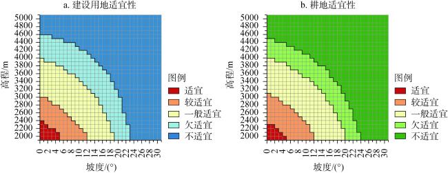
表3 建设用地和耕地适宜性评价模型参数计算公式Table 3 Parameter calculation formula of construction land and arable land suitability |
| 控制因子 | 参数名称 | 计算公式 | 公式说明 |
|---|---|---|---|
| 地形高程 | 空气密度参数 | (3) | 为空气密度参数; 为地形高程值, |
| 气温参数 | (4) | 为气温参数; 为地形高程值, | |
| 地形坡度 | 坡地适建参数 | (5) | 为坡地适建参数; 为地形坡度值, |
| 土壤抗蚀参数 | (6) (7) | 为5种作物土壤侵蚀模数平均值; 为土壤抗蚀参数; 为地形坡度值, |
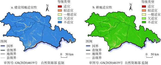
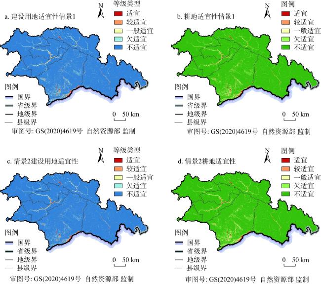
图3 基准情景下林芝市建设用地和耕地适宜性等级类型分布Fig. 3 Suitability grade type distribution of construction land and arable land under standard scenario in Nyingchi city |
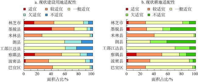
表4 基准情景下林芝市建设用地和耕地适宜性等级类型面积Table 4 Suitability grade type area of construction land and arable land under standard scenario in Nyingchi city |
| 类型 | 等级 | 面积/km2 | 林芝市 | ||||||||
|---|---|---|---|---|---|---|---|---|---|---|---|
| 巴宜区 | 波密县 | 察隅县 | 工部江达县 | 朗县 | 米林县 | 墨脱县 | 面积/km2 | 比例/% | |||
| 建设用地 适宜性 | 适宜 | 1.79 | 36.33 | 80.81 | 0 | 0 | 0.01 | 586.86 | 705.81 | 0.62 | |
| 较适宜 | 124.51 | 145.42 | 265.34 | 0 | 0 | 135.73 | 1147.50 | 1818.49 | 1.59 | ||
| 一般适宜 | 390.93 | 535.10 | 800.67 | 287.60 | 74.19 | 452.09 | 2870.07 | 5410.65 | 4.73 | ||
| 欠适宜 | 434.32 | 712.24 | 1408.09 | 289.86 | 100.94 | 376.86 | 3064.00 | 6386.30 | 5.58 | ||
| 不适宜 | 7610.85 | 15358.30 | 28978.94 | 12383.74 | 3930.89 | 8532.78 | 23291.50 | 100087.00 | 87.48 | ||
| 耕地适宜性 | 适宜 | 1.61 | 35.17 | 77.07 | 0 | 0 | 0.01 | 582.79 | 696.64 | 0.61 | |
| 较适宜 | 159.08 | 171.17 | 289.17 | 0 | 0.95 | 183.10 | 1179.06 | 1982.54 | 1.73 | ||
| 一般适宜 | 378.79 | 557.07 | 892.06 | 299.47 | 79.03 | 427.25 | 3380.25 | 6013.92 | 5.26 | ||
| 欠适宜 | 290.24 | 513.96 | 1056.48 | 205.58 | 67.38 | 251.22 | 2852.10 | 5236.96 | 4.58 | ||
| 不适宜 | 7732.67 | 15510.02 | 29219.07 | 12456.15 | 3958.65 | 8635.90 | 22965.72 | 100478.19 | 87.82 | ||
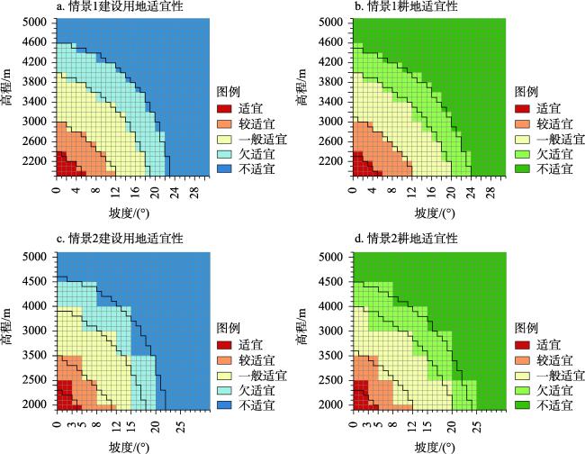
图5 情景1和情景2下林芝市建设用地和耕地适宜性等级类型分布Fig. 5 Suitability grade type distribution of construction land and arable land under scenarios 1 and 2 in Nyingchi city |
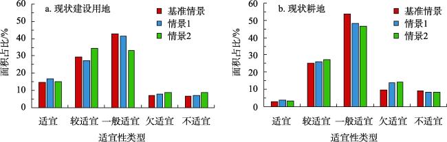
表5 情景1和情景2下林芝市建设用地和耕地适宜性等级类型面积Table 5 Suitability grade type area of construction land and arable land under scenarios 1 and 2 in Nyingchi city |
| 类型 | 等级 | 基准情景 | 情景1 | 情景2 | |||||
|---|---|---|---|---|---|---|---|---|---|
| 面积/km² | 比例/% | 面积/km2 | 比例/% | 面积/km2 | 比例/% | ||||
| 建设用地 适宜性 | 适宜 | 705.81 | 0.62 | 832.94 | 0.73 | 711.11 | 0.62 | ||
| 较适宜 | 1818.49 | 1.59 | 1679.01 | 1.47 | 1891.55 | 1.65 | |||
| 一般适宜 | 5410.65 | 4.73 | 4909.64 | 4.29 | 3639.16 | 3.18 | |||
| 欠适宜 | 6386.30 | 5.58 | 6083.14 | 5.32 | 5211.11 | 4.55 | |||
| 不适宜 | 100087.00 | 87.48 | 100903.51 | 88.20 | 102955.32 | 89.99 | |||
| 耕地适 宜性 | 适宜 | 696.64 | 0.61 | 832.94 | 0.73 | 711.11 | 0.62 | ||
| 较适宜 | 1982.54 | 1.73 | 1861.51 | 1.63 | 1891.55 | 1.65 | |||
| 一般适宜 | 6013.92 | 5.26 | 5433.79 | 4.75 | 5634.34 | 4.92 | |||
| 欠适宜 | 5236.96 | 4.58 | 6146.55 | 5.37 | 6850.65 | 5.99 | |||
| 不适宜 | 100478.19 | 87.82 | 100133.46 | 87.52 | 99320.59 | 86.81 | |||
| [1] |
张东菊, 申旭科, 成婷, 等. 青藏高原史前人类活动研究新进展. 科学通报, 2020, 65(6): 475-482.
[
|
| [2] |
张镱锂, 刘林山, 王兆锋, 等. 青藏高原土地利用与覆被变化的时空特征. 科学通报, 2019, 64(27): 2865-2875.
[
|
| [3] |
|
| [4] |
傅伯杰, 欧阳志云, 施鹏, 等. 青藏高原生态安全屏障状况与保护对策. 中国科学院院刊, 2021, 36(11): 1298-1306.
[
|
| [5] |
史培军, 陈彦强, 马恒, 等. 再论青藏高原近地表大气相对氧含量影响因素的贡献率. 科学通报, 2021, 66(31): 4028-4035.
[
|
| [6] |
新华通讯社. 习近平致中国科学院青藏高原综合科学考察研究队的贺信. http://www.xinhuanet.com//politics/2017-08/19/c_1121509919.htm, 2017-08-19/2022-05-05.
[
|
| [7] |
达瓦次仁, 次仁, 白玛卓嘎, 等. 搬迁对移民生产、生活的影响研究: 基于日喀则地区五个移民村案例分析. 西藏研究, 2013, (3): 48-57.
[
|
| [8] |
桑才让, 冯永香. 三江源地区生态移民后续产业发展问题探讨. 攀登, 2012, 31(6): 61-68.
[
|
| [9] |
|
| [10] |
|
| [11] |
|
| [12] |
杨子生. 山区城镇建设用地适宜性评价方法及应用: 以云南省德宏州为例. 自然资源学报, 2016, 31(1): 64-76.
[
|
| [13] |
张海朋, 何仁伟, 刘运伟, 等. 青藏高原高寒牧区聚落用地适宜性评价及其重构: 以藏北那曲县为例. 自然资源学报, 2020, 35(3): 698-712.
[
|
| [14] |
郭月婷, 廖和平, 徐建刚. 三峡库区农村居民点用地适宜性评价. 农业工程学报, 2012, 28(5): 252-259.
[
|
| [15] |
|
| [16] |
毕玮, 党小虎, 马慧, 等. “藏粮于地”视角下西北地区耕地适宜性及开发潜力评价. 农业工程学报, 2021, 37(7): 235-243.
[
|
| [17] |
金贵, 王占岐, 李伟松, 等. 模糊证据权法在西藏一江两河流域耕地适宜性评价中的应用. 自然资源学报, 2014, 29(7): 1246-1256.
[
|
| [18] |
|
| [19] |
|
| [20] |
|
| [21] |
|
| [22] |
|
| [23] |
|
| [24] |
|
| [25] |
|
| [26] |
|
| [27] |
樊杰. 国家汶川地震灾后重建规划资源环境承载能力评价. 北京: 科学出版社, 2009.
[
|
| [28] |
樊杰. 玉树地震灾后恢复重建资源环境承载能力评价. 北京: 科学出版社, 2010.
[
|
| [29] |
樊杰. 芦山地震灾后恢复重建资源环境承载能力评价. 北京: 科学出版社, 2014.
[
|
| [30] |
樊杰. 主体功能区划技术规程. 北京: 科学出版社, 2019.
[
|
| [31] |
中华人民共和国自然资源部. 资源环境承载能力和国土空间开发适宜性评价指南(试行). http://www.gov.cn/zhengce/zhengceku/2020-01/22/content_5471523.htm, 2020-01-19/2022-05-05.
[Ministry of Natural Resources of the People's Republic of China. Assessment guidelines for resource and environmental carrying capacity and territorial development suitability. http://www.gov.cn/zhengce/zhengceku/2020-01/22/content_5471523.htm, 2020-01-19/2022-05-05.
|
| [32] |
林振耀, 吴祥定. 青藏高原气候区划. 地理学报, 1981, 36(1): 22-32.
[
|
| [33] |
中国人民解放军总装备部. 中国参考大气 (地面-80 km) (GJB 5601—2006).
[General Armament Department of People's Liberation Army. China reference atmosphere (ground-80 km) (GJB 5601-2006).]
|
| [34] |
徐勇, 赵燊, 樊杰. 中国城市规划建设用地标准及气候和地形地貌修订. 地理学报, 2020, 75(1): 194-208.
[
|
| [35] |
杨波, 徐勇. 黄土高原坡耕地苜蓿产量及水土流失地形分异模拟: 以延安燕沟流域为例. 地理科学进展, 2010, 29(5): 530-534.
[
|
| [36] |
徐勇, 杨波, 刘国彬, 等. 黄土高原作物产量及水土流失地形分异模拟. 地理学报, 2008, 63(11): 1218-1226.
[
|
| [37] |
徐勇, 甘国辉, 王志强. 基于WIN-YIELD软件的黄土丘陵区作物产量地形分异模拟. 农业工程学报, 2005, 21(7): 61-64.
[
|
| [38] |
徐勇, 田均良, 刘普灵, 等. 黄土高原坡耕地水土流失地形分异模拟. 水土保持学报, 2005, 19(5): 20-23.
[
|
| [39] |
|
| [40] |
|
/
| 〈 |
|
〉 |