
精明收缩理念下的资源型城市生态安全格局修复实施路径设计——以冷水江锡矿山为例
|
黄一凡(1997- ),女,宁夏银川人,硕士,研究方向为收缩城市与规划应对。E-mail: Ceirayifan@163.com |
收稿日期: 2022-04-18
修回日期: 2022-10-12
网络出版日期: 2023-01-28
基金资助
国家自然科学基金项目(52078197)
The implementation of ecological security pattern restoration of resource-depleted city based on smart shrinkage principles: The case study of Xikuangshan district in Lengshuijiang
Received date: 2022-04-18
Revised date: 2022-10-12
Online published: 2023-01-28
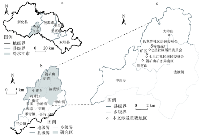
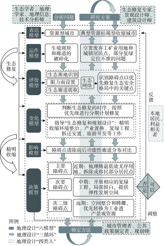
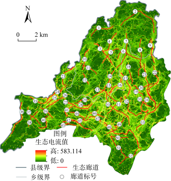
资源型城市通常面临环境恶化、景观破碎、生态流动性受阻等问题,生态系统亟需修复;同时,其作为收缩城市的重要类型之一,人口外流、经济衰退导致大量用地废弃与房屋空置,低效的用地亟需调整。以冷水江市锡矿山为例,本文将传统生态安全格局修复范式引入到收缩城市空间治理工作中,以电流密度计算结果得到的关键生态流路径和障碍点作为分期修复的依据,结合实际土地利用情况制定分区分期收缩计划,对关键障碍点进行再利用设计策略思考并检验修复效果。将生态安全格局分析和资源型城市空间收缩治理相结合,整合“生态分析—政策研究—规划设计”探索符合资源枯竭城市分步式生态修复路径,及其土地利用和空间形态分期、有序地实现精明收缩和地理设计方法。
黄一凡 , 周恺 , 涂婳 , 戴燕归 , 刘化高 . 精明收缩理念下的资源型城市生态安全格局修复实施路径设计——以冷水江锡矿山为例[J]. 自然资源学报, 2023 , 38(1) : 171 -185 . DOI: 10.31497/zrzyxb.20230111
Most resource-depleted cities face the problems of environmental degradation, landscape fragmentation, and blocked ecological mobility, in which their broken ecosystems are in urgent need for restoration. Meanwhile, resource-depleted cities are also typically shrinking cities. Under the impacts of population outflow, economic recession, and physical decay, there appeared a large quantity of abandoned lands and vacant houses, with inefficient sites in urgent need for restructuring. At the same time, these fragmented patches and corridors in the ecological system also provide opportunities for the restoration of ecological security patterns. This paper explores a GeoDesign method that combines the processes of ecological restoration and spatial governance in a shrinking city, using the case of Xikuangshan district in Lengshuijiang city. First of all, following the standard process of ecological restoration, i.e. "identifying ecological sources, constructing resistance surfaces, extracting corridors, acquiring key nodes, and constructing ecological networks", the research constructs conductance surfaces based on the InVEST model, and uses the circuit theory modeling to simulate natural ecological landscape patches. The key ecological flow paths are identified according to the strength of the current. Secondly, based on the spatial distribution of important ecological corridors and patches identified, the key obstacle points in the ecological network that need restoration are selected. Finally, a zonal phased plan is developed with reference to the existing land use, the effect of ecological restoration is tested using the afore-mentioned model, and eventually, the urban design strategy is considered for the regeneration and reuse of the abandoned lands and vacant houses on the key obstacle nodes. This research aims to bridge the analytical method of ecological restoration with the demands for spatial shrinkage of the resource-depleted city, in order to formulate a step-by-step GeoDesign method by integrating 'ecological analysis-policy study-planning design', from which the shrinking resource-depleted city is able to achieve smart shrinkage and ecological restoration.
表1 生态系统服务评估方法Table 1 Ecosystem service assessment methods |
| 服务因子 | 评估方法/模型 | 基本原理解释 | 权重 |
|---|---|---|---|
| 土地利用现状 | 提取草地、林地、水体等城市绿色基础设施要素 | 草地、林地、水体具有较高生境质量,可以作为基本生态源地。利用ENVI监督分类解译遥感数据并修正,提取草地、林地、水体等城市绿色基础设施要素作为基本生态源地 | 0.30 |
| 固碳释氧 | InVEST模型③Carbon模块 | 利用地上、地下、土壤和死有机体中每个碳库的最小碳量之和来表示。碳密度相关参数参考前人研究成果[38]与InVEST模型手册确定④ | 0.10 |
| 生境质量 | InVEST模型③Habitat Quality模块 | 以土地利用数据、每一种威胁性土地利用类型的相对影响、生境栅格与威胁因子之间的距离(表2,数据所需相关参数参考InVEST模型手册④,并根据当地情况进行相应调整)、每一类生境对每一种威胁因子的相对敏感性4个因素综合评价维持生物多样性服务[11] | 0.20 |
| 栖息地风险 | InVEST模型③的Habitat Risk Assessment 模块 | 通过判断生境暴露于压力源的可能性及其暴露后果,结合暴露程度与响应值去给每个压力源—生境联合体生成一个对应的风险值,量化所有压力源对生境的累积风险,辨别处于风险热点的生境区域④ | 0.15 |
| 气候调节 | 城市生态智慧管理模型的气候调节(降温)模型 | 以生态系统蒸腾蒸发消耗的能量和植被蒸腾消耗的能量来表征气候调节服务 | 0.10 |
| 水敏感 | 城市生态智慧管理模型的水敏感模型(日常游憩) | 对主要的河流、公园绿地、果园、茶园、坑塘和沟渠,以行人不同时间下的步行距离分别做缓冲区,结合水敏感模型提取不同等级的水敏感范围⑤ | 0.15 |
③ 已有研究大多将InVEST模型应用于宏观尺度,但相关研究一直在建议将其在微观尺度下进行探索应用;考虑到模型在微观尺度下的敏感性和不确定性,首先,本文在“固碳释氧”模型中采用精度高且来源可靠的土地利用数据,提高微观尺度下估算碳储存量的计算结果精度;其次,“生境质量”模型中将锡矿山、中连乡、渣渡镇三个行政区作为研究区范围,拓展纳入分析的景观边界,减少因人工边界划定造成生境威胁被忽视的情况;最后,“栖息地风险评估”模型各类压力源及其暴露后果的信息的评分没有统一标准,本文参考已有的研究进行评分。基于以上,将InVEST模型应用在本案例中的误差在可接受范围之内。 ④ 斯坦福大学NATURAL CAPITAL PROJECT的InVEST模型官方网站,https://naturalcapitalproject.stanford.edu/software/invest. ⑤ 城市生态智慧管理模型(Intelligent Urban Ecosystem Management System),https://www.iuems.ac.cn/eco/index.html. |
表2 威胁因子属性表Table 2 Attribute of threat factors |
| 威胁因子 | 相对权重 | 最大影响距离/km | 空间衰退类型 |
|---|---|---|---|
| 草地 | 0.2 | 2 | 线性 |
| 林地 | 0.2 | 1 | 线性 |
| 城镇建设用地 | 1.0 | 10 | 指数 |
| 农村居民点 | 1.0 | 8 | 指数 |
| 工矿用地 | 1.0 | 10 | 指数 |
| 农业用地 | 0.8 | 6 | 线性 |
| 水域 | 0.2 | 3 | 指数 |
| 裸地 | 1.0 | 10 | 指数 |
| 道路用地 | 0.8 | 6 | 指数 |
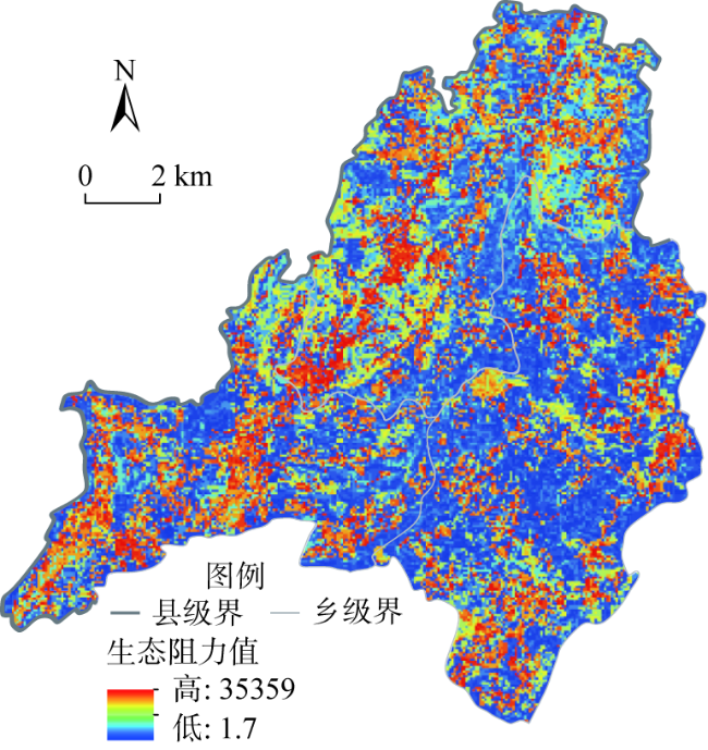
表3 景观类型阻力赋值Table 3 Landscape type resistance assignment |
| 土地利用 类型 | 亚类 | 阻力值 | 土地利用 类型 | 亚类 | 阻力值 | 土地利用 类型 | 亚类 | 阻力值 |
|---|---|---|---|---|---|---|---|---|
| 林地 | 竹林地 | 1 | 农业用地 | 水浇地 | 30 | 城镇住宅用地 | 正利用500 | |
| 乔木林地 | 1 | 沟渠 | 50 | 废弃300 | ||||
| 灌木林地 | 3 | 水田 | 50 | 公园与绿地 | 250 | |||
| 其他林地 | 5 | 旱地 | 100 | 设施农用地 | 350 | |||
| 草地 | 其他草地 | 5 | 建设用地 | 公用设施用地 | 300 | 采矿用地 | 正利用500 | |
| 水体 | 河流水面 | 7 | 商业服务业设施 用地 | 废弃350 | ||||
| 水库水面 | 9 | 科教文卫用地 | 工业用地 | 正利用500 | ||||
| 农业用地 | 坑塘水面 | 10 | 机关团体新闻出版用地 | 废弃350 | ||||
| 养殖坑塘 | 10 | 水工建筑用地 | 未利用地 | 裸土地 | 300 | |||
| 茶园 | 15 | 物流仓储用地 | 350 | 空闲地 | 250 | |||
| 果园 | 15 | 特殊用地 | 道路用地 | 公路用地 | 300 | |||
| 可调整果园 | 15 | 交通服务场站用地 | 农村道路 | 200 | ||||
| 其他园地 | 15 | 农村宅基地 | 300 | 城镇村道路 用地 | 200 |
表4 地形坡度阻力赋值Table 4 Terrain slope resistance assignment |
| 坡度类型 | 坡度范围/(°) | 阻力值 | 高程范围/m | 阻力值 |
|---|---|---|---|---|
| 平坡 | <5 | 1 | 222~300 | 1 |
| 缓坡 | 5~15 | 10 | 301~500 | 10 |
| 斜坡 | 15~25 | 30 | 501~700 | 30 |
| 陡坡 | 25~35 | 50 | 701~900 | 50 |
| 急坡 | >35 | 100 | 900~997 | 100 |
| [1] |
陈影, 哈凯, 贺文龙, 等. 冀西北间山盆地区景观格局变化及优化研究: 以河北省怀来县为例. 自然资源学报, 2016, 31(4): 556-569.
[
|
| [2] |
张豆, 渠丽萍, 张桀滈. 基于生态供需视角的生态安全格局构建与优化: 以长三角地区为例. 生态学报, 2019, 39(20): 7525-7537.
[
|
| [3] |
毛诚瑞, 代力民, 齐麟, 等. 基于生态系统服务的流域生态安全格局构建: 以辽宁省辽河流域为例. 生态学报, 2020, 40(18): 6486-6494.
[
|
| [4] |
田雅楠, 张梦晗, 许荡飞, 等. 基于“源—汇”理论的生态型市域景观生态安全格局构建. 生态学报, 2019, 39(7): 2311-2321.
[
|
| [5] |
王玉莹, 沈春竹, 金晓斌, 等. 基于MSPA和MCR模型的江苏省生态网络构建与优化. 生态科学, 2019, 38(2): 138-145.
[
|
| [6] |
王戈, 于强,
[
|
| [7] |
彭建, 李慧蕾, 刘焱序, 等. 雄安新区生态安全格局识别与优化策略. 地理学报, 2018, 73(4): 701-710.
[
|
| [8] |
陈昕, 彭建, 刘焱序, 等. 基于“重要性—敏感性—连通性”框架的云浮市生态安全格局构建. 地理研究, 2017, 36(3): 471-484.
[
|
| [9] |
彭建, 郭小楠, 胡熠娜, 等. 基于地质灾害敏感性的山地生态安全格局构建: 以云南省玉溪市为例. 应用生态学报, 2017, 28(2): 627-635.
[
|
| [10] |
沈钦炜, 林美玲, 莫惠萍, 等. 佛山市生态网络构建及优化. 应用生态学报, 2021, 32(9): 3288-3298.
[
|
| [11] |
宁琦, 朱梓铭, 覃盟琳, 等. 基于MSPA和电路理论的南宁市国土空间生态网络优化研究. 广西大学学报: 自然科学版, 2021, 46(2): 306-318.
[
|
| [12] |
|
| [13] |
刘合林. 收缩城市量化计算方法进展. 现代城市研究, 2016, (2): 17-22.
[
|
| [14] |
周恺, 钱芳芳, 严妍. 湖南省多地理尺度下的人口“收缩地图”. 地理研究, 2017, 36(2): 267-280.
[
|
| [15] |
张俊杰, 叶杰, 刘巧珍, 等. 基于“精明收缩”理论的广州城边村空间规划对策. 规划师, 2018, 34(7): 77-85.
[
|
| [16] |
|
| [17] |
|
| [18] |
|
| [19] |
|
| [20] |
|
| [21] |
|
| [22] |
王国霞, 刘婷. 中部地区资源型城市城市化与生态环境动态耦合关系. 中国人口·资源与环境, 2017, 27(7): 80-88.
[
|
| [23] |
|
| [24] |
刘辉, 张志赟, 税伟, 等. 资源枯竭型城市增长边界划定研究: 以淮北市为例. 自然资源学报, 2017, 32(3): 391-405.
[
|
| [25] |
王振波, 张蔷, 张晓瑞, 等. 基于资源环境承载力的合肥市增长边界划定. 地理研究, 2013, 32(12): 2302-2311.
[
|
| [26] |
|
| [27] |
魏璐瑶, 陈晓红. 基于精明发展的城市绩效与生态环境耦合研究: 以哈长城市群为例. 地理科学, 2017, 37(7): 1032-1039.
[
|
| [28] |
|
| [29] |
王振山, 张绍良, 陈浮, 等. 中国城市土地集约与生态利用协同度测度: 以31个省会城市为例. 城市问题, 2015, (11): 38-44.
[
|
| [30] |
衣霄翔, 赵天宇, 吴彦锋, 等. “危机”抑或“契机”?应对收缩城市空置问题的国际经验研究. 城市规划学刊, 2020,(2): 95-101.
[
|
| [31] |
吴康, 李耀川. 收缩情境下城市土地利用及其生态系统服务的研究进展. 自然资源学报, 2019, 34(5): 1121-1134.
[
|
| [32] |
|
| [33] |
|
| [34] |
|
| [35] |
王雨村, 王影影, 屠黄桔. 精明收缩理论视角下苏南乡村空间发展策略. 规划师, 2017, 33(1): 39-44.
[
|
| [36] |
管雯君, 杨传勇. 自然资源部统筹下的新型地理设计思路探索. 规划师, 2018, 34(12): 68-72.
[
|
| [37] |
马劲武. 地理设计简述: 概念、 框架及实例. 风景园林, 2013, (1): 26-32.
[
|
| [38] |
|
| [39] |
尹海伟, 孔繁花, 祈毅, 等. 湖南省城市群生态网络构建与优化. 生态学报, 2011, 31(10): 2863-2874.
[
|
| [40] |
尹海伟, 孔繁花. 城市与区域规划空间分析实验教程(第三版). 南京: 东南大学出版社, 2018: 508.
[
|
| [41] |
方莹, 王静, 黄隆杨, 等. 基于生态安全格局的国土空间生态保护修复关键区域诊断与识别: 以烟台市为例. 自然资源学报, 2020, 35(1): 190-203.
[
|
| [42] |
王回茴, 李汉廷, 谢苗苗, 等. 资源型城市工矿用地系统修复的生态安全格局构建. 自然资源学报, 2020, 35(1): 162-173.
[
|
| [43] |
周恺, 戴燕归, 涂婳. 收缩城市的形态控制: 断面模型与精明收缩的耦合框架. 国际城市规划, 2020, 35(2): 20-28.
[
|
| [44] |
|
/
| 〈 |
|
〉 |
