
面向国土空间规划实施监督的监测评估预警模型体系研究
|
钟镇涛(1993- ),男,新疆库尔勒人,硕士,助理工程师,研究方向为自然资源信息化与智慧国土空间规划。E-mail: zztoozzt@qq.com |
收稿日期: 2021-10-08
修回日期: 2022-05-29
网络出版日期: 2023-01-28
基金资助
国家自然科学基金项目(41871318)
国家自然科学基金项目(42171410)
Research on model system of monitoring-evaluation-warning for implementation supervision of territory spatial planning
Received date: 2021-10-08
Revised date: 2022-05-29
Online published: 2023-01-28
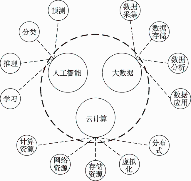
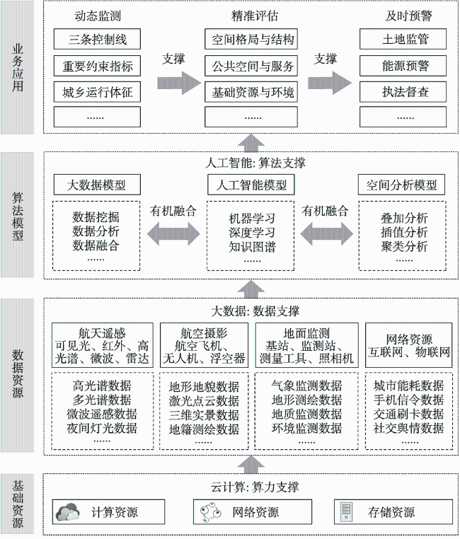
国土空间规划监测评估预警是监督规划实施管理、保障规划实施成效的重要手段,也是实现“可感知、能学习、善治理、自适应”智慧规划转型的关键支撑。针对当前国土空间规划监测评估预警研究重机制、轻理论,以及缺乏一套科学可用的监测评估预警技术方法支撑的不足,在系统分析国土空间规划监测评估预警目标与内涵的基础上,构建以人工智能(Artificial Intelligence)、大数据(Big Data)、云计算(Cloud Computing)等新型信息技术(“ABC”技术)为支撑,覆盖国土空间规划“监测—评估—预警”业务全生命周期的应用模型体系,并结合信息系统建设案例,介绍了基于“ABC”技术的国土空间规划监测评估预警模型体系对实现各地国土空间规划“动态监测、精准评估、及时预警”的重要支撑作用。
钟镇涛 , 张鸿辉 , 刘耿 , 罗伟玲 . 面向国土空间规划实施监督的监测评估预警模型体系研究[J]. 自然资源学报, 2022 , 37(11) : 2946 -2960 . DOI: 10.31497/zrzyxb.20221113
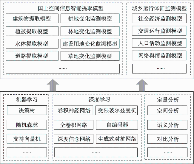
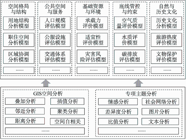
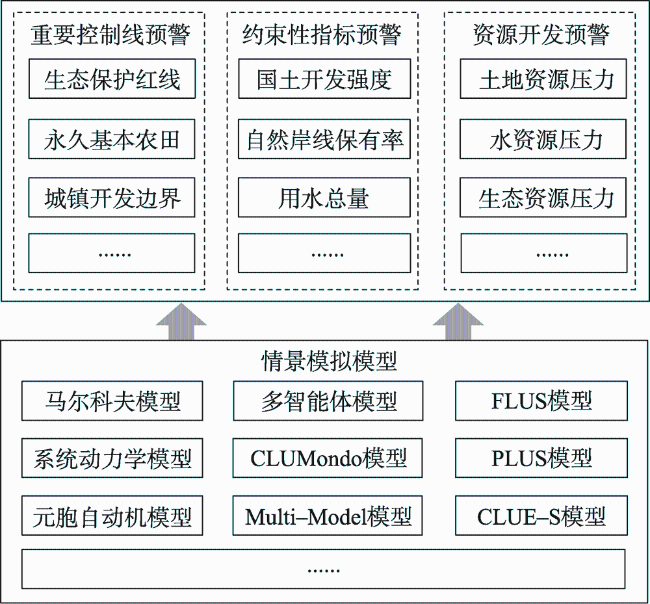
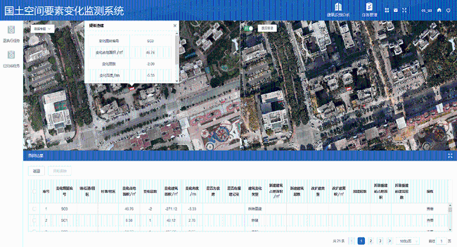
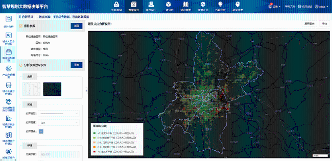
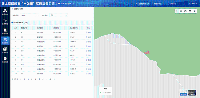
The monitoring-evaluation-warning of territory spatial planning is not only an important means to supervise and ensure the effectiveness of spatial planning implementation, but also a key support for the evolution of smart planning that is "perceptible, learnable, governable and adaptive". At present, research on monitoring-evaluation-warning of national spatial planning focuses more on mechanism rather than theory, what's more important is that we are lack of a set of scientifically available monitoring-evaluation-warning techniques. In order to solve the above problems, this paper systematically analyzes and discusses the objectives and connotation of monitoring-evaluation-warning of national spatial planning, and on this basis, it constructs an application model system that covers the whole life cycle of monitoring-evaluation-warning of territory spatial planning business supported by new information technologies ("ABC" technology), such as artificial intelligence, big data and cloud computing. Finally, combined with the case of information system construction, the paper introduces the important supporting role of monitoring-evaluation-warning of territory spatial planning model system based on "ABC" technology to realize the territory spatial planning "dynamic monitoring, accurate evaluation and timely early warning". The main conclusions of this paper are as follows: (1) Monitoring, evaluation and early warning of territory spatial planning are indispensable technical links in the implementation and supervision of spatial planning, and the three are logically progressive and technologically support each other. (2) Three kinds of model systems are put forward: the dynamic perception and rapid identification model system of spatial information integrated with multi-source big data, the comprehensive evaluation model system coupling human activities and natural environment, and the land simulation and prediction model system based on artificial intelligence. (3) The practical application of three kinds of models in the information platform such as the territorial space change monitoring system, the smart planning big data decision-making platform and the 'Inteplan' information system for implementation and supervision of spatial planning embodies the important role of the model in territorial space control and governance as well as natural resources supervision.
| [1] |
中华人民共和国自然资源部. 关于全面开展国土空间规划工作的通知, http://gi.mnr.gov.cn/201905/t20190530_2439129.html, 2019-05-28.
[Ministry of Natural Resources of the PRC. Notice on comprehensively carrying out national spatial planning, http://gi.mnr.gov.cn/201905/t20190530_2439129.html, 2019-05-28.]
|
| [2] |
中华人民共和国自然资源部. 关于开展国土空间规划“一张图”建设和现状评估工作的通知, http://www.mnr.gov.cn/dt/pl/201907/t20190726_2449331.html, 2019-07-26.
[Ministry of Natural Resources of the PRC. Notice on carrying out "One Map" construction and current situation evaluation of national spatial planning, http://www.mnr.gov.cn/dt/pl/201907/t20190726_2449331.html, 2019-07-26.]
|
| [3] |
中华人民共和国自然资源部. 关于加强国土空间规划监督管理的通知, http://gi.mnr.gov.cn/202005/t20200526_2521189.html, 2020-05-22.
[Ministry of Natural Resources of the PRC. Notice on strengthening the supervision and administration of national spatial planning, http://gi.mnr.gov.cn/202005/t20200526_2521189.html, 2020-05-22.]
|
| [4] |
张吉康, 杨枫, 罗罡辉. 浅谈国土空间规划监测评估的路径. 中国土地, 2019, (9): 12-15.
[
|
| [5] |
吴洪涛. 自然资源信息化总体架构下的智慧国土空间规划. 城乡规划, 2019, (6): 6-10.
[
|
| [6] |
王伟. 国土空间整体性治理与智慧规划建构路径. 城乡规划, 2019, (6): 11-17.
[
|
| [7] |
霍雅琦. 国土空间规划“一张图”动态监测评估指标和技术框架研究. 厦门: 华侨大学, 2020.
[
|
| [8] |
林立伟, 沈山, 江国逊. 中国城市规划实施评估研究进展. 规划师, 2010, 26(3): 14-18.
[
|
| [9] |
|
| [10] |
张万益, 崔敏利, 贾德龙. 美国密西西比河流域治理的若干启示. 中国矿业报, 2018-07-03(01).
[
|
| [11] |
孙博文, 李雪松. 国外江河流域协调机制及对中国发展的启示. 区域经济评论, 2015, (2): 156-160.
[
|
| [12] |
周姝天, 翟国方, 施益军. 英国空间规划的指标监测框架与启示. 国际城市规划, 2018, 33(5): 126-131.
[
|
| [13] |
张健, 王旭, 李强. 国土空间规划监测预警机制建构逻辑与策略. 见: 中国城市规划学会. 2020中国城市规划年会本文集. 成都: 中国城市规划学会, 2021: 680-687.
[
|
| [14] |
建设部“规划风景监管系统”项目组. 城乡规划监管步入信息化. 建设科技, 2003, (11): 26-27.
[Urban Remote Sensing and Urban Information System. Urban and rural planning supervision into information. The Construction of Science and Technology, 2003, (11): 26-27.]
|
| [15] |
李学芹, 陆敏燕. 开展地理空间动态监测助力规划有效落地: 江苏局推进主体功能区监测工作纪实. 中国测绘, 2017, (1): 21-23.
[
|
| [16] |
甄峰, 张姗琪, 秦萧, 等. 从信息化赋能到综合赋能: 智慧国土空间规划思路探索. 自然资源学报, 2019, 34(10): 2060-2072.
[
|
| [17] |
孔宇, 甄峰, 李兆中, 等. 智能技术辅助的市(县)国土空间规划编制研究. 自然资源学报, 2019, 34(10): 2186-2199.
[
|
| [18] |
龚强. 测绘地理信息科技融合新技术助力空间规划编制. 测绘与空间地理信息, 2018, 41(9): 153-156.
[
|
| [19] |
秦萧, 甄峰, 李亚奇, 等. 国土空间规划大数据应用方法框架探讨. 自然资源学报, 2019, 34(10): 2134-2149.
[
|
| [20] |
郝庆, 彭建, 魏冶, 等. “国土空间”内涵辨析与国土空间规划编制建议. 自然资源学报, 2021, 36(9): 2219-2247.
[
|
| [21] |
胡最, 闵庆文. 构建农业文化遗产数字化保护的概念框架探讨. 地球信息科学学报, 2021, 23(9): 1632-1645.
[
|
| [22] |
黄永进, 基静萍, 孙华芸, 等. 遥感技术在“一张图”实施监督系统中的应用. 测绘通报, 2021, (4): 156-159.
[
|
| [23] |
张帆, 刘瑜. 街景影像——基于人工智能的方法与应用. 遥感学报, 2021, 25(5): 1043-1054.
[
|
| [24] |
洪武扬, 唐豪. 深圳城市生态空间监测评估体系的建设与应用. 中国土地, 2021, (4): 44-45.
[
|
| [25] |
钮心毅, 李凯克. 跨城功能联系视角下的都市圈国土空间规划实施监测. 资源科学, 2021, 43(2): 380-389.
[
|
| [26] |
金忠民, 陈琳, 陶英胜. 超大城市国土空间总体规划实施监测技术方法研究: 以上海为例. 上海城市规划, 2019, (4): 9-16.
[
|
| [27] |
杨帆, 孙晖, 王帅. 基于GIS的中国城市规划实施评估模式研究. 规划师, 2015, 31(2): 20-24.
[
|
| [28] |
解瑶, 张军民, 单建树. 近五年中国城市总体规划实施评估研究综述. 上海城市规划, 2015, (6): 21-26.
[
|
| [29] |
张萌. 县级国土空间规划实施评估实证与评估体系构建研究. 杭州: 浙江大学, 2020.
[
|
| [30] |
廖茂羽, 罗震东. 城市总体规划实施评估的方法体系与研究进展. 上海城市规划, 2015, (1): 82-88.
[
|
| [31] |
李灿, 张凤荣, 王枫, 等. 快速城镇化过程中建设用地空间安全预警分析. 中国土地科学, 2015, 29(6): 49-56.
[
|
| [32] |
周颖. 运用系统动力学对武汉市城市土地集约利用预警研究. 杭州: 浙江大学, 2014.
[
|
| [33] |
王保盛, 廖江福, 祝薇, 等. 基于历史情景的 FLUS 模型邻域权重设置: 以闽三角城市群 2030 年土地利用模拟为例. 生态学报, 2019, 39(12): 4284-4298.
[
|
| [34] |
曹帅, 金晓斌, 杨绪红, 等. 耦合MOP与GeoSOS-FLUS模型的县级土地利用结构与布局复合优化. 自然资源学报, 2019, 34(6): 1171-1185.
[
|
| [35] |
|
/
| 〈 |
|
〉 |