
市域国土空间格局多维度分解与传导路径
|
王世磊(1996- ),男,山东莒县人,硕士,主要从事国土空间格局优化研究。E-mail: 17854122347@163.com |
收稿日期: 2021-11-08
修回日期: 2022-05-29
网络出版日期: 2023-01-28
基金资助
国家自然科学基金项目(42077434)
国家自然科学基金项目(41771560)
山东省高等学校“青年创新团队发展计划”项目(2019RWG016)
Research on multi-dimensional decomposition and conduction path of territory spatial pattern at the municipal level
Received date: 2021-11-08
Revised date: 2022-05-29
Online published: 2023-01-28
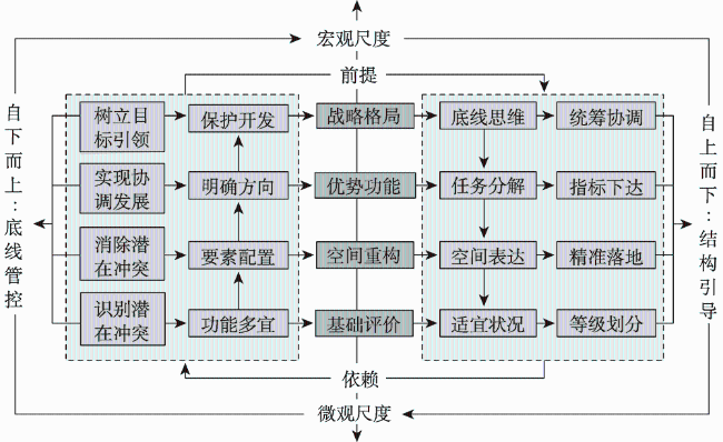
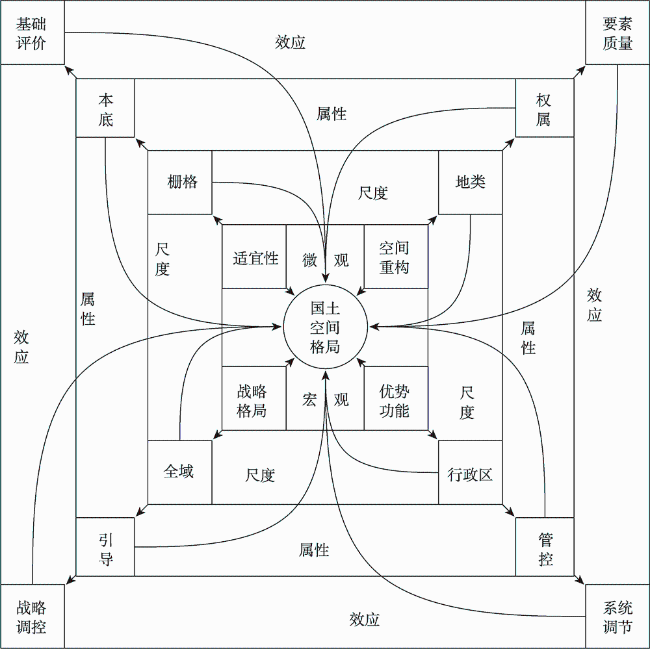
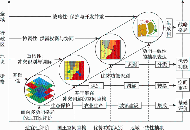
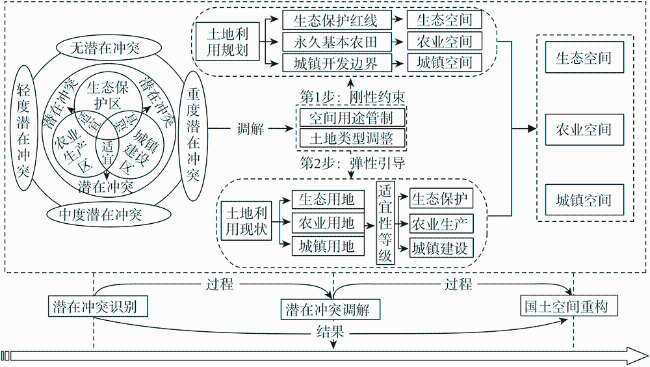
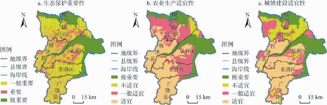
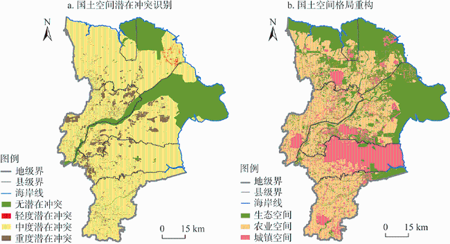
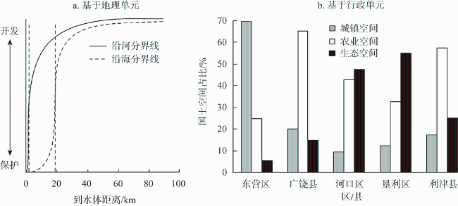
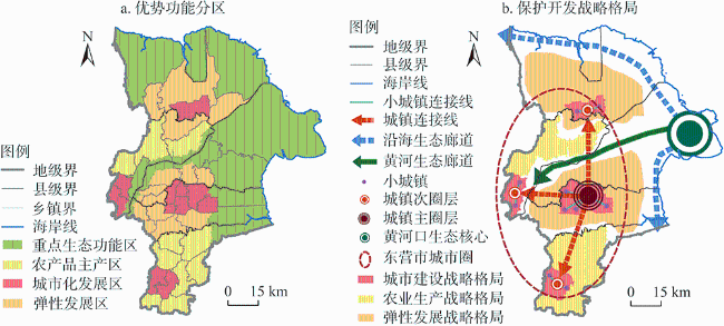
国土空间格局对协调区域保护与开发具有重要保障作用,其基本前提在于厘清国土空间格局内涵并构建科学有效的传导路径。由此提出国土空间格局多维度分解与传导路径研究框架,围绕生态保护、农业生产和城镇建设三个方面开展适宜性评价,基于国土空间潜在冲突识别与调解机制实现国土空间重构,运用区位熵识别优势功能分区,进而构建战略格局,并以东营市为例开展案例研究。研究发现:东营市国土空间适宜性表现为“生态保护重要、农业生产和城镇建设适宜”,潜在冲突以中度为主;国土空间重构包括农业空间、生态空间和城镇空间,地理单元的空间分异和行政单元的面积占比差别明显;优势功能分区包含重要生态功能区、农产品生产区、城市化发展区和弹性发展区,提供了分区分类的差别化管控策略;国土空间保护与开发战略格局包括“一心一屏一廊”的生态保护格局、“一圈两区”的开发利用格局和“两带”的弹性发展格局,树立了可持续国土空间利用的目标引领。研究结果可为新时期国土空间规划编制与实施以及协调区域国土资源有效配置提供有益借鉴。
王世磊 , 曲衍波 , 宗海柠 , 张彦军 , 关梅 , 张勇 . 市域国土空间格局多维度分解与传导路径[J]. 自然资源学报, 2022 , 37(11) : 2803 -2818 . DOI: 10.31497/zrzyxb.20221104
Territory spatial pattern plays an important role in coordinating regional protection and development. Its basic premise is to clarify the connotation of territory spatial pattern and build a scientific and effective conduction path of territory spatial pattern. Based on the logic lines of "raster-land category-administrative region-whole area" and "suitability evaluation-territory spatial reconstruction-dominant function identification-regional consistency abstraction", this study develops a research framework for territory spatial pattern scale decomposition and conduction path. Firstly, the suitability of territorial space is assessed in terms of three aspects: ecological protection, agricultural production, and urban construction, with the type, intensity, and spatial pattern of territory spatial potential conflict identified using a model for identifying territory spatial potential conflict. Secondly, the "rigid constraint" and "elastic guidance" planning mechanisms are applied to mediate potential conflicts in territorial space and reconstruct the territorial spatial pattern. Finally, the location entropy model is utilized to determine the dominant function of territorial space and to establish a strategic plan for territory spatial development. Dongying city is used as an example in this research to conduct an empirical study. The results show that: (1) The territory spatial suitability of Dongying is crucial for ecological protection, suitable for agricultural production and urban construction, and the potential conflicts of territorial space are mainly moderate. (2) Ecological space, agricultural space, and urban space are all part of the territory spatial reconstruction. From coastline and coastal areas to inland regions, the boundary between protection and development in geographical units is 19.69 km and 1.6 km, respectively. The proportions of territory spatial reconstruction patterns, on the other hand, vary substantially between counties (cities and districts). (3) Dominant function zones include important ecological function zones, agricultural production zones, urbanization development zones and elastic development zones that provide differentiated control strategies for zoning classification. (4) The ecological protection pattern of "one heart, one screen, and one corridor", the development and utilization pattern of "one circle and two districts," and the flexible development pattern of "two belts" comprise the strategic pattern of territory spatial protection and development, which establishes the goal of sustainable territory spatial utilization. The findings of this study can be used as a guide for developing territory spatial planning and coordinating the effective allocation of regional territory and resources in the New Era.
| [1] |
陈明星, 梁龙武, 王振波, 等. 美丽中国与国土空间规划关系的地理学思考. 地理学报, 2019, 74(12): 2467-2481.
[
|
| [2] |
陈明星, 周园, 汤青, 等. 新型城镇化、居民福祉与国土空间规划应对. 自然资源学报, 2020, 35(6): 1273-1287.
[
|
| [3] |
中华人民共和国中央人民政府. 中共中央国务院关于建立国土空间规划体系并监督实施的若干意见, http://www.gov.cn/zhengce/2019-05-23/content_5394187.html, 2019-05-23.]
[The Central People's Government of the PRC. Several opinions of the Central Committee of the Communist Party of China on establishing territorial spatial planning system and supervising implementation, http://www.gov.cn/zhengce/2019-05-23/content_5394187.html, 2019-05-23.]
|
| [4] |
中华人民共和国自然资源部. 市级国土空间总体规划编制指南(试行), http://gi.mnr.gov.cn/202009/t20200924_2561550.html, 2020-09-20.
[Ministry of Natural Resources of PRC. Guidelines for the preparation of municipal territorial spatial master plan (trial), http://gi.mnr.gov.cn/202009/t20200924_2561550.html, 2020-09-20.]
|
| [5] |
杨庆媛, 罗奎, 劳昕. 基于地理学视角的国际空间规划嬗变与启示. 地理学报, 2020, 75(6): 1223-1236.
[
|
| [6] |
|
| [7] |
孔冬艳, 陈会广, 吴孔森. 中国“三生空间”演变特征、生态环境效应及其影响因素. 自然资源学报, 2021, 36(5): 1116-1135.
[
|
| [8] |
曲衍波, 王世磊, 朱伟亚, 等. 黄河三角洲国土空间演变的时空分异特征与驱动力分析. 农业工程学报, 2021, 37(6): 252-263.
[
|
| [9] |
赵筱青, 李思楠, 普军伟, 等. 云南喀斯特山区国土空间优化分区与管控. 自然资源学报, 2020, 35(10): 2339-2357.
[
|
| [10] |
|
| [11] |
樊杰. 中国主体功能区划方案. 地理学报, 2015, 70(2): 186-201.
[
|
| [12] |
王回茴, 李汉廷, 谢苗苗, 等. 资源型城市工矿用地系统修复的生态安全格局构建. 自然资源学报, 2020, 35(1): 162-173.
[
|
| [13] |
陈雯, 孙伟, 吴加伟, 等. 长江经济带开发与保护空间格局构建及其分析路径. 地理科学进展, 2015, 34(11): 1388-1397.
[
|
| [14] |
|
| [15] |
|
| [16] |
傅丽华, 彭耀辉, 谢美, 等. 山区县国土空间规划协同的弹性空间测度: 以湖南省茶陵县为例. 地理科学进展, 2020, 39(7): 1085-1094.
[
|
| [17] |
杨荫凯. 国家空间规划体系的背景和框架. 改革, 2014, (8): 125-130.
[
|
| [18] |
郝庆. 对机构改革背景下空间规划体系构建的思考. 地理研究, 2018, 37(10): 1938-1946.
[
|
| [19] |
王开泳, 陈田. 新时代的国土空间规划体系重建与制度环境改革. 地理研究, 2019, 38(10): 2541-2551.
[
|
| [20] |
徐晶, 杨昔. 国土空间规划传导体系与实施机制探讨. 中国土地, 2020, (8): 21-24.
[
|
| [21] |
牛彦合, 焦胜, 夏依宁, 等. 基于红色旅游的国土空间规划层级传导与冲突协调研究. 自然资源学报, 2021, 36(11): 2723-2735.
[
|
| [22] |
岳文泽, 吴桐, 王田雨, 等. 面向国土空间规划的“双评价”: 挑战与应对. 自然资源学报, 2020, 35(10): 2299-2310.
[
|
| [23] |
郝庆, 彭建, 魏冶, 等. “国土空间”内涵辨析与国土空间规划编制建议. 自然资源学报, 2021, 36(9): 2219-2247.
[
|
| [24] |
金贵, 王占岐, 姚小薇, 等. 国土空间分区的概念与方法探讨. 中国土地科学, 2013, 27(5): 48-53.
[
|
| [25] |
卢庆强, 尚嫣然, 崔音. 省级国土空间规划空间格局构建逻辑与技术体系. 规划师, 2021, 37(6): 11-18.
[
|
| [26] |
朱从谋, 王珂, 张晶, 等. 国土空间治理内涵及实现路径: 基于“要素—结构—功能—价值”视角. 中国土地科学, 2022, 36(2): 10-18.
[
|
| [27] |
尚嫣然, 张悦, 薛昊天. 市县联动的国土空间规划传导体系研究: 以湖北省黄冈市为例. 规划师, 2021, 37(19): 35-40.
[
|
| [28] |
自然资源部. 资源环境承载能力和国土空间开发适宜性评价指南(试行), http://gi.mnr.gov.cn/202001/t20200121_2498502.html, 2020-01-19.
[Ministry of Natural Resources of PRC. Guidelines for the evaluation of the carrying capacity of resources and environment and the suitability of territorial space development (trial), http://gi.mnr.gov.cn/202001/t20200121_2498502.html, 2020-01-19.]
|
| [29] |
巩垠熙, 刘若梅, 王发良, 等. 多元信息综合的市县国土空间规划空间功能识别方法. 自然资源学报, 2021, 36(8): 2006-2019.
[
|
| [30] |
夏皓轩, 岳文泽, 王田雨, 等. 省级“双评价”的理论思考与实践方案: 以浙江省为例. 自然资源学报, 2020, 35(10): 2325-2338.
[
|
| [31] |
李思楠, 赵筱青, 普军伟, 等. 西南喀斯特典型区国土空间地域功能优化分区. 农业工程学报, 2020, 36(17): 242-253.
[
|
| [32] |
|
| [33] |
董雯, 杜宏茹, 周艳时. 乌昌地区资源产业的集聚特征及其城市化效应研究. 自然资源学报, 2010, 25(4): 657-667.
[
|
| [34] |
张佰林, 张凤荣, 高阳, 等. 农村居民点多功能识别与空间分异特征. 农业工程学报, 2014, 30(12): 216-224.
[
|
| [35] |
辜寄蓉, 朱明仓, 江浏光艳, 等. 国土空间规划中弹性空间的作用与划分. 中国农业资源与区划, 2019, 40(12): 39-47.
[
|
| [36] |
王万茂, 王群. 土地利用规划中不确定性的识别和处理研究. 中国人口·资源与环境, 2011, 21(10): 84-90.
[
|
| [37] |
樊杰. 主体功能区战略与优化国土空间开发格局. 中国科学院院刊, 2013, 28(2): 193-206.
[
|
| [38] |
|
| [39] |
秦萧, 甄峰, 李亚奇, 等. 国土空间规划大数据应用方法框架探讨. 自然资源学报, 2019, 34(10): 2134-2149.
[
|
| [40] |
赵筱青, 李思楠, 谭琨, 等. 城镇—农业—生态协调的高原湖泊流域土地利用优化. 农业工程学报, 2019, 35(8): 296-307.
[
|
| [41] |
金贵, 邓祥征, 张倩, 等. 武汉城市圈国土空间综合功能分区. 地理研究, 2017, 36(3): 541-552.
[
|
/
| 〈 |
|
〉 |