
面向实施的市级国土空间规划传导思路与技术方法
|
李晓晖(1980- ),男,广东鹤山人,硕士,高级工程师,研究方向为国土空间规划、生态保护、低碳城市规划等。E-mail: 25017306@qq.com |
收稿日期: 2021-10-08
修回日期: 2022-05-23
网络出版日期: 2023-01-28
基金资助
广东省城市感知与监测预警企业重点实验室基金项目(2020B121202019)
广州市城市规划勘测设计研究院科技基金项目(RDI2210202155)
Research on the ideas and methods of conducting technology for implementation of territory spatial planning
Received date: 2021-10-08
Revised date: 2022-05-23
Online published: 2023-01-28
李晓晖 , 詹美旭 , 李飞 , 鄢金明 , 肖越 . 面向实施的市级国土空间规划传导思路与技术方法[J]. 自然资源学报, 2022 , 37(11) : 2789 -2802 . DOI: 10.31497/zrzyxb.20221103
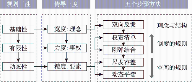
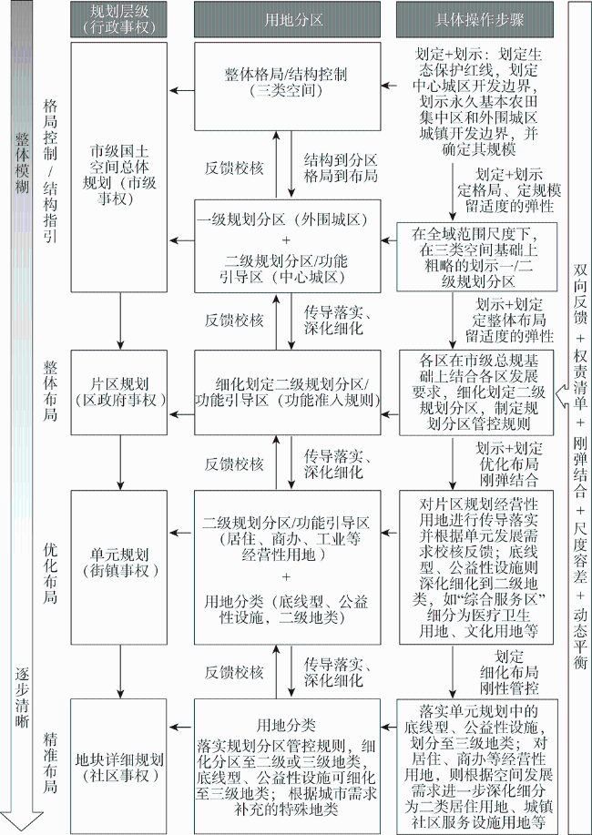
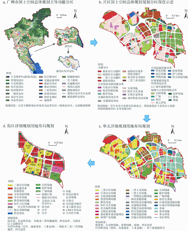
National territory spatial planning is a guide for national spatial development, a spatial blueprint for sustainable development, and an important starting point for improving the modernization of the national spatial governance system and governance capabilities. Therefore, it is essential to promote the effective implementation of national territory spatial planning. Planning transmission is a key link to ensure the implementation of national territory spatial planning. There are several reasons for problems in the compilation and implementation of national territory spatial planning. Due to the lag of planning theories and methods, and the limitations of local practice, existing research results emphasize the vertical transmission of rigid constraints, functional zoning, spatial elements, etc. People are currently inadequately considering the transformation of space governance in the New Era, the unification of administrative power management boundaries, and the accuracy control of the transmission of spatial elements, which has led to the defect in transmission of technical ideas for national territory spatial planning. This article is based on the preparation and pilot practice of Guangzhou's land and space planning, starting with the transformation of governance at the conceptual level, the matching of government duties at the system level, and the management of elements at the technical level, to explore the integrating spatial governance into planning transmission, the rigid constraints of national will and the flexible guidance of local competitiveness, and the intensity and precision of administrative control at different spatial scales. The paper points out that planning transmission should adopt technical ideas such as two-way feedback, power and responsibility list, rigid and elastic combination, scale tolerance, dynamic balance, etc., to solve the key issues of planning transmission between different levels of master plans, and between master plans and detailed plans. It further proposes that planning conduction is not simply a "top-down" vertical conduction, but should also include "two-way feedback" in response to local development demands and specific field regulations, and a rigid conduction mechanism must be used to transmit strategic intentions downwards. When dealing with the relationship between the government and the market, it is necessary to strengthen flexible control and guidance to enhance the flexibility and adjustability of planning; in terms of the transmission of spatial elements such as land zoning, control line delineation, special facility layout, etc., administrative control of different spatial scales should be grasped through the process of adapting the space from overall blur to partial clarity, from structure to map spots, from partition to plot, from demarcation to delineation, to clarify the tasks, permissions and control accuracy of each level of planning. Follow the dynamic balance principles of "constant scale, variable form", "constant standard, variable location" and other dynamic balance principles to allocate space resources in a reasonable and detailed manner to cope with the dynamic changes of the influencing factors of the planning and layout plan during the implementation process, so as to finally realize the ecological environment. The comprehensive balance of civilization and urban economic development, rigid constraints and flexible adjustments, refined management and fuzziness. The results can provide research support for improving the national territory spatial planning system in the era of ecological civilization and promoting the effective implementation of planning.
| 城市 | 空间规划传导层级 | 传导内容 | 传导思路方法 |
|---|---|---|---|
| 北京 | 市—区—街区(单元)—地块 | 宏观战略、目标指标、两线三区、用途分区等 | “总体规划—分区规划—街区指引(单元)—街区详规”的四级传导路径;逐级深化的用地标准,明确各层级规划用地分类间的关系 |
| 上海 | 市—区—单元—地块 | 战略目标、指标、用地分区、四条控制线、城市设计要素等约束性指标 | 空间合一、专项协同、时间合拍;明确各类管控要素的分级管控方式,实现成果深度的差异表达,如划示到划定的层级划线思路;“结构线”到“控制线”到“图斑线”逐层传导路径 |
| 深圳 | 市—区—标准 单元 | 指标、规则、分区、名录、边界、位置、结构 | 市区两级总规同步编制,上下联动、相互反馈;全域划分“标准单元”(规划传导、监督评估和图则编制的基本单元);明确不同要素在各级规划中的编制深度和衔接要求,形成落实、深化、优化、增补四种传导方式 |
| 佛山 | 市—区—功能 区—编制单元 —街坊 | 目标定位与指标体系、控制线、格局与功能布局、用地布局、设施要素 | 市级统筹、五区联动、专项协同;“结构—一级规划分区—二级规划分区(详规单元)—地块(用途地类)”的传导路径;定性、定量、定位、定界和综合控制五类管控方式 |
| 东莞 | 市—片区—镇(街)—单元 | 底线控制、定位目标、结构格局、规划分区、设施配置 | 规划层级对应事权,明确各层级规划管控的内容、要素、管控方式的差异化要求;以片区指引和管理单元为载体构建市—镇总规和镇总规—详规的传导机制 |
| 嘉兴 | 市—市辖县(区、市)—镇街 | 结构、指标、分区、边界、名录、位置、规则 | 事权对应、刚弹并济;上下联动、统导结合;政策支撑、成果保障的总思路 |
表2 市级空间规划传导要素与事权分层管控规则建议(部分)Table 2 Suggestions on transmission elements and hierarchical management and control rules of municipal spatial planning (part) |
| 管控要素 | 要素 细分 | 市(总体规划) | 区/县 (总体规划) | 部门 (专项规划) | 镇街(详细规划 /单元规划) | 管控方式与 传导深度 |
|---|---|---|---|---|---|---|
| 指标 | 指标 体系 | 明确需落实和分解至区/县的指标体系 | 落实约束性指标+增补引导性指标 | 落实约束性指标+细化/增补引导性指标 | 落实市、区/县规划关键指标 | 数量管控为主,可不用落实到空间 |
| 目标 规模 | 明确发展目标、各类用地总量及比例 | 落实/细化发展目标+落实/细化/优化用地总量及比例 | 落实/细化专项用地总量 | 落实/细化/优化/增补相关目标和用地要求 | 数量管控为主,允许适当细化/优化/增补 | |
| 体系 | 自然 资源 体系 | 统筹确定全市生态保护格局、自然资源总体格局、农业发展格局 | 细化/增补相关生态、自然资源和农业格局 | 细化/增补专项格局控制要求 | 细化/增补相关格局内容 | 格局管控为主,可细化/ 增补 |
| 城—镇—村 体系 | 统筹确定市—区/县—市级以上重点镇/特色镇—市级以上村的发展体系及空间格局 | 细化/增补区/县级以上镇、村的发展体系与总体格局 | 细化/增补市 级以上镇、村 的发展体系与 总体格局 | 细化/增补各类镇街及村的发展体系与空间格局 | 格局管控为主,可细化/增补不同等级的镇村规划要点 | |
| 公共 中心 体系 | 统筹确定全市公共中心体系及市级以上公共中心布局 | 细化公共中心体系,增补区/县级公共中心布局 | 细化/增补公共中心体系及相关布局 | 细化/增补公共中心布局 | 格局管控为主,可细化/增补不同等级的公共中心布局 | |
| 规划 分区 | 全域划定一级规划分区,中心城区划定二级规划分区 | 全域细化市级一级分区,中心城区划定二级规划分区 | 细化/优化一级与二级规划分区、可适当增补二级规划分区 | 细化/优化/增补规划二级规划分区,增补规划三级分区/用地分类 | 分区管控,细化/增补为主,可适当优化 | |
| 功能 分区 | 全域确定各类功能分区,中心城区确定主导功能分区 | 全域细化/优化/增补各类功能分区 | 全域细化/优化 /增补各类功能分区 | 细化/优化/ 增补各类功 能分区 | 分区管控,可细化/优化/增补各类分区 | |
| 设施 | 交通 基础 设施 | 确定全市交通规划体系、结构布局和配置标准,统筹确定市级以上重大交通设施位置 | 细化交通规划体系与结构布局,增补区/县级重大交通设施位置 | 细化/增补交通规划体系与设施布局,细化重大交通设施位置 | 细化/增补交 通设施位置 | 位置管控,可细化/增补各类交通基础设施 |
| 市政 基础 设施 | 确定全市市政基础设施体系、结构布局、线性工程走向和配置标准,统筹确定市级以上重大市政基础设施位置 | 细化市政基础设施体系、结构布局、线性工程走向,增补区/县级以上重大设施位置 | 细化/增补市政基础设施体系、结构布局、线性工程走向和配置标准,细化重大市政设施位置 | 细化/增补市 政基础设施 位置和线性 工程走向 | 位置管控,可细化/增补各类市政基础设施 | |
| 公共 服务 设施 | 确定全市公共服务设施体系、结构布局和配置标准,统筹确定市级以上公共服务设施位置 | 细化公共服务设施体系、结构布局和配置标准,增补区/县级以上公共服务设施位置 | 细化/增补公共服务设施体系、结构布局、和配置标准,细化重大公共服务设施位置 | 细化/增补公共服务设施位置和配置标准 | 位置管控,可细化/增补各类公共服务设施 | |
| 管控要素 | 要素 细分 | 市(总体规划) | 区/县 (总体规划) | 部门 (专项规划) | 镇街(详细规划 /单元规划) | 管控方式与 传导深度 |
| 底线 | 生态 红线 | 由市级划定边界、明 确规模,贯穿到县区、乡镇 | 落实市级生态红线划定方案 | 落实市级生态 红线划定方案 | 落实市级生态红线划定方案 | 位置管控, 直接落实 |
| 永久 基本 农田 | 由市级划定集中保护区、统筹区县方案 | 区县与市级同编,划定具体边界 | 划定集中保护 区和具体边界 | 落实永久基本农田划定方案 | 位置管控, 上下协同 后落实 | |
| 城镇 开发 边界 | 市级划定市辖区内城镇边界、重点产业园区边界,划示县城和乡镇开发边界 | 区县与市级同编,落实/细化城区、园区和乡镇开发边界 | 落实/细化划 定全市开发边 界方案 | 落实/细化城镇开发边界方案 | 位置管控, 上下协同 后落实/细化 | |
| 其他 控制线 | 市级统筹划定 | 落实/细化/优化控制线方案 | 落实/细化/优 化控制线方案 | 落实/细化/优化控制线方案 | 位置管控, 可落实/细 化/优化 | |
| 事项 | 发展 定位 | 统筹确定全市及区/县发展定位 | 细化/增补区/县发展定位 | 细化/优化/增 补发展定位 | 细化/优化/增补发展定位 | 名录管控, 可细化/优 化/增补 |
| 保护 要素 清单 | 统筹确定全市自然、历史等各类保护名录清单 | 细化/增补区/县各类保护名录清单 | 细化/增补各类保护名录清单 | 细化/增补各类保护名录清单 | ||
| 重点 项目与 工程 | 统筹确定全市各类重点项目和工程清单 | 细化/增补区/县各类项目和工程清单 | 细化/增补各类重点项目和工程清单 | 细化/增补各类项目和工程清单 |
表3 规划传导的尺度容差示例(道路、公服和控制线)Table 3 Example of scale tolerance for planning transmission |
| 空间要素 | 总体规划(≥1∶10000) | 详细规划(≥1∶2000) | |||
|---|---|---|---|---|---|
| 市级 | 区县级 | 单元层次 | 地块 | ||
| 道路 | 骨干路网 | 主干路、次干路;道路三线 | 次干路和支路;道路五线和横断面 | 带坐标及标高的道路 | |
| 公共服 务设施 | 定界:重要设施定点:其他设施 | 定界(划示):市区级设施定点:社区级设施 | 定界(划定):市区级设施定点:社区级设施 | 定界(包括边界坐标):所有设施 | |
| 城镇开 发边界 | 划定:中心城区划示:其他地区总量框定+“结构线” | 划定:中心城区划示:其他地区总量框定+“结构线” | 划定(“图斑线” /实线) | 划定(“图斑线”/实线) | |
| [1] |
中华人民共和国中央人民政府. 中共中央国务院关于建立国土空间规划体系并监督实施的若干意见. 中国政府网, http://www.gov.cn/zhengce/2019-05-23/content_5394187.htm, 2019-05-23.
[The Central People's Government of the PRC. Several opinions of the Central Committee of the Communist Party of China on establishing a land and space planning system and supervising implementation. Chinese Government Website, http://www.gov.cn/zhengce/2019-05-23/content_5394187.htm, 2019-05-23.]
|
| [2] |
自然资源部办公厅. 自然资源部办公厅关于印发《市级国土空间总体规划编制指南(试行)》的通知, http://gi.mnr.gov.cn/202009/t20200924_2561550.html
[General Office of the Ministry of Natural Resources of the People's Republic of China. Notice of the General Office of the Ministry of Natural Resources on printing and distributing the Guidelines for the Compilation of Municipal Land and Space Master Plans (for Trial Implementation). Chinese Government Website, http://gi.mnr.gov.cn/202009/t20200924_2561550.html.]
|
| [3] |
谢英挺, 吴宇翔, 魏立军 市级国土空间总体规划的效用与编制管控策略: 空间治理视角的探讨. 城市规划, 2021, 45(6): 46-51, 116.
[
|
| [4] |
陈川, 徐宁, 王朝宇, 等. 市县国土空间总体规划与详细规划分层传导体系研究. 规划师, 2021, 37(15): 75-81.
[
|
| [5] |
汪鑫. “市级”国土空间总体规划编制内容与深度研究: 基于空间治理的视角. 城市规划, 2020, 45(5): 76-82.
[
|
| [6] |
牛彦合, 焦胜, 夏依宁, 等. 基于红色旅游的国土空间规划层级传导与冲突协调研究. 自然资源学报, 2021, 36(11): 2723-2735.
[
|
| [7] |
谭纵波, 龚子路. 任务导向的国土空间规划思考: 关于实现生态文明的理论与路径辨析. 城市规划, 2019, 43(9): 61-68.
[
|
| [8] |
李莉, 左玉强. 省级国土空间规划传导体系构建及运行机制研究. 上海城市规划, 2021, 31(3): 42-47.
[
|
| [9] |
丁强, 邹兵, 戴垠澍. 存量发展背景下深圳市国土空间规划的探索和思考. 城乡规划, 2021, 13(z1): 27-30.
[
|
| [10] |
胡智行. 空间规划传导机制中的“刚”与“柔”: 以上海崇明区为例. 城市规划, 2021, 45(5): 68-75.
[
|
| [11] |
张京祥, 夏天慈. 治理现代化目标下国家空间规划体系的变迁与重构. 自然资源学报, 2019, 34(10): 2040-2050.
[
|
| [12] |
姚凯, 杨颖. 市级国土空间规划的统筹与传导实践探索. 南方建筑, 2021, 41(2): 34-38.
[
|
| [13] |
周宜笑, 谭纵波. 德国规划体系空间要素纵向传导的路径研究: 基于国土空间规划的视角. 城市规划, 2020, 44(9): 68-77.
[
|
| [14] |
田莉, 李经纬. 高密度地区解决土地问题的启示: 纽约城市规划中的土地开发与利用. 北京规划建设, 2019, 33(1): 88-96.
[
|
| [15] |
左为, 唐燕, 陈冰晶. 新时期国土空间规划的基础逻辑关系思辨. 规划师, 2019, 35(13): 5-13.
[
|
| [16] |
常青, 石晓冬, 杨浚. 新时代推动国土空间规划重构的实践探索: 以北京为例. 城市规划, 2021, 45(5): 61-67.
[
|
| [17] |
凌莉. “体系衔接与治理创新”: 上海市单元规划的演进与探索. 上海城市规划, 2018, 28(4): 80-85.
[
|
| [18] |
钱竞, 郑沁, 赖权有. 新时期深圳市国土空间规划体系重构的思考. 国土资源情报, 2020, 21(8): 51-56.
[
|
| [19] |
王海蒙, 石春晖, 高浩歌. 国土空间详细规划编制技术路线构建. 规划师, 2021, (17): 17-22.
[
|
| [20] |
谭宇文, 李颖, 陈昌勇. 佛山市国土空间规划传导策略. 规划师, 2021, 37(6): 60-67.
[
|
| [21] |
龚蔚霞, 周剑云. 府际事权划分视角下的市域国土空间规划协调路径思考: 以东莞市为例. 城乡规划, 2021, (5): 117-124.
[
|
| [22] |
黄凯迪, 许旺土. 新国土空间规划体系下交通规划的适应性变革: 以厦门为例. 城市规划, 2019, 43(7): 21-33.
[
|
| [23] |
詹美旭, 魏宗财, 王建军, 等. 面向国土空间安全的城市体检评估方法及治理策略: 以广州为例. 自然资源学报, 2021, 36(9): 2382-2393.
[
|
| [24] |
李双成, 王羊, 蔡运龙. 复杂性科学视角下的地理学研究范式转型. 地理学报, 2010, 65(11): 1315-1324.
[
|
| [25] |
詹美旭, 席广亮. 面向全域要素统一空间管制的市级国土空间规划编制探索. 规划师, 2021, 37(10): 34-40.
[
|
| [26] |
孔雪松, 朱思阳, 金志丰. 国土空间用途管制刚性与弹性的互动逻辑及优化路径. 规划师, 2020, 36(11): 11-15.
[
|
| [27] |
郝庆, 彭建, 魏冶, 等. 国土空间”内涵辨析与国土空间规划编制建议. 自然资源学报, 2021, 36(9): 2219-2247.
[
|
| [28] |
徐毅松, 熊健, 范宇, 等. 关于上海建立国土空间规划体系并监督实施的实践和思考. 城市规划学刊, 2020, 64(3): 57-64.
[
|
| [29] |
王新哲, 薛皓颖. 国土空间总体规划传导体系中的语汇建构. 城市规划学刊, 2019, 63(s1): 9-14.
[
|
| [30] |
赵坤, 许景权, 沈迟. 基于人类行为视角的市县国土空间总体规划管控措施编制思路探究. 自然资源学报, 2019, 34(10): 2234-2243.
[
|
/
| 〈 |
|
〉 |