
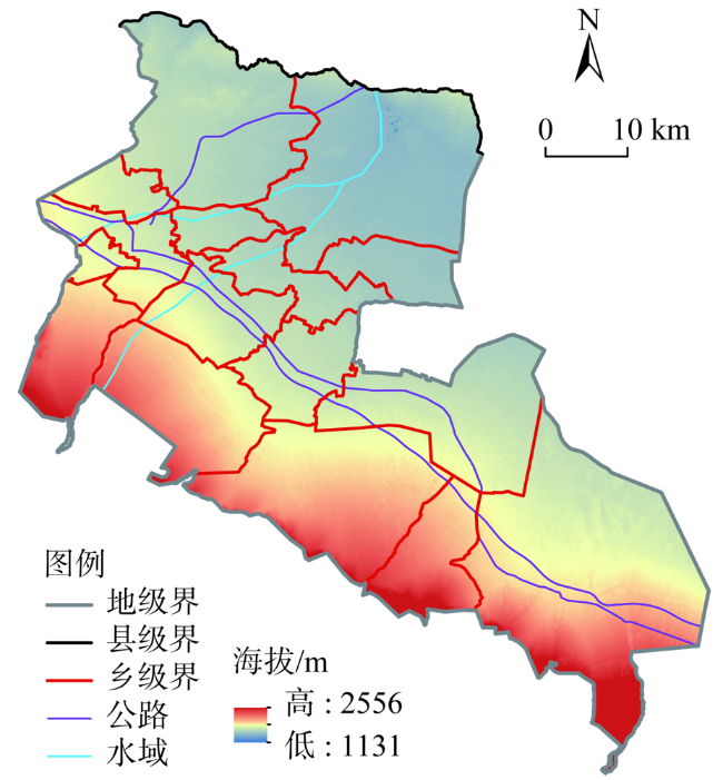
基于栅格尺度的生态安全评价及生态修复——以酒泉市肃州区为例
|
王梓洋(1996- ),男,甘肃庆阳人,博士研究生,研究方向为城市与区域发展研究。E-mail: 2019212399@nwnu.edu.cn |
收稿日期: 2021-08-23
修回日期: 2022-01-12
网络出版日期: 2022-12-28
基金资助
国家自然科学基金项目(41771130)
国家自然科学基金项目(42101276)
国家自然科学基金项目(42161043)
甘肃省科技计划项目(20JR5RA529)
Grid-scale-based ecological security assessment and ecological restoration:A case study of Suzhou district, Jiuquan
Received date: 2021-08-23
Revised date: 2022-01-12
Online published: 2022-12-28
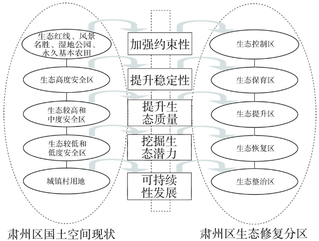
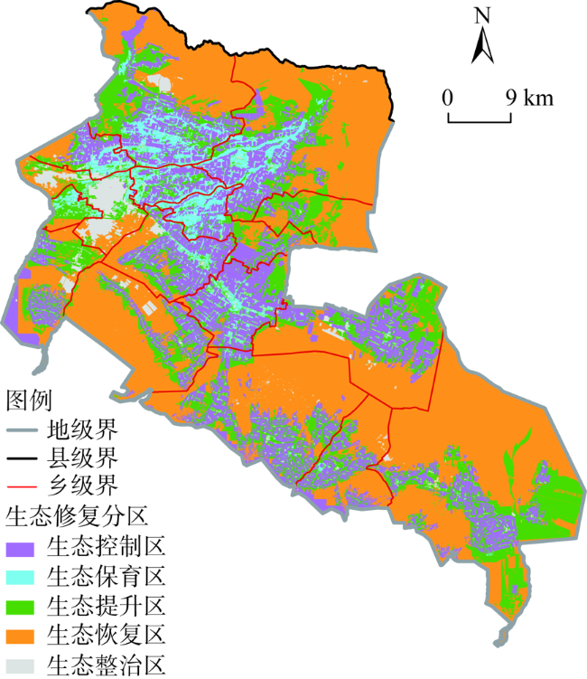
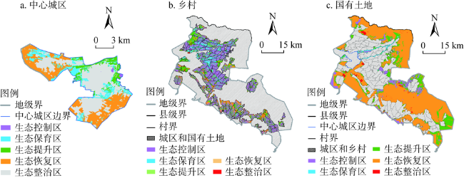
以节约优先、保护优先和自然恢复的方针为导向,基于栅格尺度评价生态安全状态,并开展国土空间生态修复分区,有助于实施精准修复、降低生态修复成本以及增加生态修复效益。本文以酒泉市肃州区为例,从环境基底和人类干扰的视角遴选评价因子,采用空间主成分分析法(SPCA)基于栅格尺度对生态安全进行评价,并将宏观尺度的生态保护红线和永久基本农田保护等现实约束条件与栅格尺度的生态安全评价结果相结合,实现精准的生态修复分区。结果表明:研究区整体生态安全水平偏低,中度安全水平及以下的面积为1391.65 km2,占研究区总面积的71.35%,生态安全格局总体呈中部高、四周低的特征。肃州区国土空间生态修复分区共划分出5个类型区,其中生态恢复区面积最大,占研究区总面积的46.17%。生态控制、生态保育、生态提升和生态整治四个类型区在乡村分布最多,说明肃州区乡村生态修复的复杂度、难度和重要程度更高。本文运用新的生态修复分区研究思路,以期丰富国土空间生态保护修复规划理论与方法。
王梓洋 , 石培基 , 张学斌 , 姚礼堂 , 童华丽 . 基于栅格尺度的生态安全评价及生态修复——以酒泉市肃州区为例[J]. 自然资源学报, 2022 , 37(10) : 2736 -2749 . DOI: 10.31497/zrzyxb.20221018
Guided by the principles of conservation priority, protection priority and natural restoration, the ecological security status is evaluated based on the grid scale, and the ecological restoration zoning of land space is carried out, which is conducive to the implementation of precise restoration, reducing the cost of ecological restoration and increasing the benefits of ecological restoration. Taking Suzhou district of Jiuquan city as an example, this paper selects evaluation factors from the perspective of environmental base and human interference, and uses spatial principal component analysis (SPCA) to evaluate ecological security based on grid scale. The realistic constraints such as macro-scale ecological protection red line and permanent basic farmland protection are combined with grid-scale ecological security assessment results to realize accurate ecological restoration zoning. The results show that the overall ecological security level of the study area is relatively low, and the area of moderate security level and below is 1391.65 km2, accounting for 71.35% of the total area of the study area, the overall ecological security pattern is characterized by high in the middle and low in the surrounding area. The territorial space ecological restoration zone of Suzhou is divided into 5 types of zones, of which the ecological restoration zone is the largest area, accounting for 46.17% of the total area of the study area. The four types of ecological control, ecological conservation, ecological improvement and ecological management are most distributed in rural areas, indicating that the complexity, difficulty and importance of rural ecological restoration in Suzhou are higher. This paper uses the new research ideas of ecological restoration zoning, in order to enrich the theory and method of ecological protection and restoration planning in territorial space.
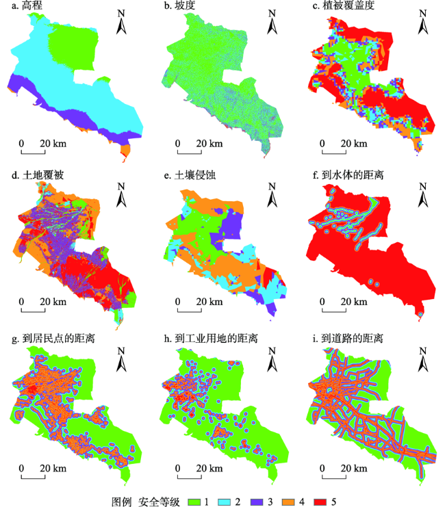
表1 肃州区生态安全评价因子及等级划分Table 1 Ecological security evaluation factors and classification of Suzhou district |
| 评价因子 | 1级(高度) | 2级(较高) | 3级(中度) | 4级(较低) | 5级(低度) | 参考文献 |
|---|---|---|---|---|---|---|
| 高程/m | <1400 | 1400~1700 | 1700~2000 | 2000~2300 | >2300 | [17,18,22] |
| 坡度/(°) | <5 | 5~10 | 10~20 | 20~30 | >30 | [17] |
| 植被覆盖度 | >0.6 | 0.45~0.6 | 0.3~0.45 | 0.15~0.3 | <0.15 | [17,18,20] |
| 土地覆被类型 | 水域、林地 | 草地 | 耕地 | 未利用地 | 建设用地 | [17,19,22] |
| 土壤侵蚀 | 微度水力侵蚀 微度风力侵蚀 | 轻度水力侵蚀 轻度风力侵蚀 轻度冻融侵蚀 | 中度水力侵蚀 中度风力侵蚀 | 强度风力侵蚀 极强度风力侵蚀 | 剧烈风力侵蚀 | [17,20] |
| 距水体距离/m | <100 | 100~500 | 500~1000 | 1000~1500 | >1500 | [19⇓-21] |
| 距居民点距离/m | >1500 | 1500~1000 | 1000~500 | 500~100 | <100 | [19,20] |
| 距工业用地距离/m | >2000 | 2000~1500 | 1500~1000 | 1000~500 | <500 | [17,19,20] |
| 距道路距离/m | >1500 | 1500~1000 | 1000~500 | 500~100 | <100 | [18,20,23] |
表2 主成分载荷矩阵Table 2 Principal component loading matrix |
| 评价因子 | 主成分 | ||||||||
|---|---|---|---|---|---|---|---|---|---|
| 1 | 2 | 3 | 4 | 5 | 6 | 7 | 8 | 9 | |
| 高程 | 0.00681 | 0.01656 | 0.10137 | 0.18699 | 0.03845 | -0.30744 | 0.45093 | 0.36913 | 0.72031 |
| 坡度 | 0.07426 | -0.01155 | 0.03377 | 0.05763 | -0.06735 | -0.13049 | 0.47406 | 0.55982 | -0.65590 |
| 植被覆盖度 | 0.58667 | 0.41982 | 0.19854 | 0.00681 | -0.30400 | -0.20990 | -0.51808 | 0.07426 | 0.17235 |
| 土地覆被类型 | 0.19854 | 0.53067 | 0.74236 | -0.14651 | -0.29555 | 0.10857 | 0.03149 | -0.07914 | 0.00244 |
| 土壤侵蚀 | 0.41982 | 0.21883 | -0.06485 | 0.21917 | 0.59717 | 0.58593 | 0.08887 | 0.11704 | 0.04583 |
| 距水体距离 | 0.17235 | 0.07974 | 0.18872 | 0.56858 | 0.32227 | -0.57410 | -0.09075 | -0.34873 | -0.20433 |
| 距居民点距离 | -0.51808 | 0.08199 | 0.28584 | 0.16855 | 0.25069 | 0.03266 | -0.53448 | 0.51487 | -0.00967 |
| 距工业用地距离 | -0.20990 | 0.43596 | -0.14150 | -0.50072 | 0.50371 | -0.31905 | 0.14473 | -0.08103 | -0.04432 |
| 距道路距离 | -0.30400 | 0.65109 | -0.45426 | 0.39898 | -0.31447 | 0.09634 | 0.07959 | -0.05864 | -0.01361 |
| 贡献率/% | 43.11 | 16.51 | 11.16 | 8.22 | 6.37 | 5.73 | 3.92 | 3.35 | 2.63 |
| 累计贡献率/% | 43.11 | 59.62 | 70.78 | 79.00 | 85.37 | 91.10 | 95.02 | 98.37 | 100.00 |
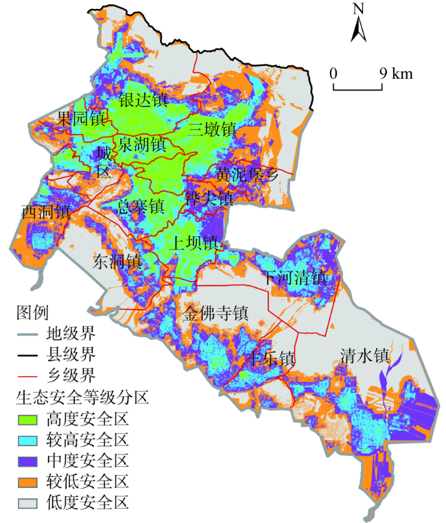
图4 肃州区生态安全评价等级分布Fig. 4 Distribution of ecological safety assessment grades in Suzhou district |
表3 肃州区生态安全等级各分区的土地覆被类型面积Table 3 The area of each land cover type in the ecological security grade zoning in Suzhou district (km2) |
| 生态安全等级分区 | 耕地 | 林地 | 草地 | 水体 | 建设用地 | 未利用地 | 总计 |
|---|---|---|---|---|---|---|---|
| 高度安全区 | 261.69 | 21.53 | 35.75 | 49.61 | 33.74 | 3.49 | 405.81 |
| 较高安全区 | 296.93 | 67.97 | 58.67 | 32.03 | 75.60 | 23.08 | 554.28 |
| 中度安全区 | 210.52 | 125.33 | 168.55 | 30.96 | 57.86 | 100.73 | 693.95 |
| 较低安全区 | 62.68 | 71.96 | 224.84 | 22.98 | 42.03 | 217.91 | 642.40 |
| 低度安全区 | 3.68 | 3.50 | 603.29 | 4.69 | 31.74 | 408.40 | 1055.30 |
表4 肃州区中心城区、乡村和国有土地各生态修复区面积Table 4 Area of ecological restoration zones in central urban areas, rural areas and state-owned land |
| 生态修复分区 | 中心城区 /km2 | 占中心城区总面积比/% | 乡村/km2 | 占乡村总面积比/% | 国有土地 /km2 | 占国有土地总面积比/% | 各分区主要土地利用类型 | 占分区面积比/% |
|---|---|---|---|---|---|---|---|---|
| 生态控制区 | 0.52 | 0.46 | 562.29 | 42.13 | 126.41 | 6.64 | 耕地 | 83.15 |
| 生态保育区 | 9.03 | 8.01 | 164.95 | 12.36 | 32.75 | 1.72 | 林草地、水域 | 74.30 |
| 生态提升区 | 19.20 | 17.03 | 390.45 | 29.26 | 358.11 | 18.80 | 耕地、林草地 | 70.03 |
| 生态恢复区 | 35.54 | 31.53 | 155.68 | 11.67 | 1356.28 | 71.22 | 戈壁荒漠 | 89.73 |
| 生态整治区 | 48.44 | 42.97 | 61.19 | 4.59 | 30.80 | 1.62 | 建设用地 | 93.16 |
| [1] |
王伟军, 赵雪雁, 张明军, 等. 西北干旱区内陆河流域公众的水资源感知及节水意向: 以甘肃省河西走廊地区为例. 中国人口·资源与环境, 2019, 29(11): 148-157.
[
|
| [2] |
|
| [3] |
温璐, 宋洁, 张慧超, 等. 近30年乌兰布和沙漠生态系统服务价值评估. 干旱区资源与环境, 2020, 34(12): 57-64.
[
|
| [4] |
|
| [5] |
|
| [6] |
李子君, 王硕, 马良, 等. 基于熵权物元模型的沂蒙山区土地生态安全动态变化及其影响因素研究. 土壤通报, 2021, 52(2): 425-433.
[
|
| [7] |
|
| [8] |
徐烨, 杨帆, 颜昌宙. 基于景观格局分析的雄安城市湿地生态健康评价. 生态学报, 2020, 40(20): 7132-7142.
[
|
| [9] |
|
| [10] |
|
| [11] |
|
| [12] |
|
| [13] |
|
| [14] |
|
| [15] |
|
| [16] |
管青春, 郝晋珉, 石雪洁, 等. 中国生态用地及生态系统服务价值变化研究. 自然资源学报, 2018, 33(2): 195-207.
[
|
| [17] |
洪步庭, 任平. 基于最小累积阻力模型的农村居民点用地生态适宜性评价: 以都江堰市为例. 长江流域资源与环境, 2019, 28(6): 1386-1396.
[
|
| [18] |
|
| [19] |
李青圃, 张正栋, 万露文, 等. 基于景观生态风险评价的宁江流域景观格局优化. 地理学报, 2019, 74(7): 1420-1437.
[
|
| [20] |
黄木易, 岳文泽, 冯少茹, 等. 基于MCR模型的大别山核心区生态安全格局异质性及优化. 自然资源学报, 2019, 34(4): 771-784.
[
|
| [21] |
陶卓霖, 喻忠磊, 王砾, 等. 基于空间区位条件的城市扩展生态阻力面模型及应用. 地理研究, 2018, 37(1): 199-208.
[
|
| [22] |
杨天荣, 匡文慧, 刘卫东, 等. 基于生态安全格局的关中城市群生态空间结构优化布局. 地理研究, 2017, 36(3): 441-452.
[
|
| [23] |
李航鹤, 马腾辉, 王坤, 等. 基于最小累积阻力模型(MCR)和空间主成分分析法(SPCA)的沛县北部生态安全格局构建研究. 生态与农村环境学报, 2020, 36(8): 1036-1045.
[
|
| [24] |
杨新军, 石育中, 王子侨. 道路建设对秦岭山区社会—生态系统的影响: 一个社区恢复力的视角. 地理学报, 2015, 70(8): 1313-1326.
[
|
| [25] |
|
| [26] |
|
| [27] |
常兆丰, 刘世增, 王祺, 等. 沙漠、戈壁光伏产业防沙治沙的生态功能: 以甘肃河西走廊为例. 生态经济, 2018, 34(8):199-208.
[
|
| [28] |
宫清华, 张虹鸥, 叶玉瑶, 等. 人地系统耦合框架下国土空间生态修复规划策略: 以粤港澳大湾区为例. 地理研究, 2020, 39(9): 2176-2188.
[
|
| [29] |
|
| [30] |
段义忠, 王佳豪, 王驰, 等. 未来气候变化下西北干旱区4种扁桃亚属植物潜在适生区分析. 生态学杂志, 2020, 39(7): 2193-2204.
[
|
| [31] |
吴文婕, 石培基, 胡巍. 基于土地利用/覆被变化的绿洲城市土地生态风险综合评价: 以甘州区为例. 干旱区研究, 2012, 29(1): 122-128.
[
|
| [32] |
蒙吉军, 江颂, 拉巴卓玛, 等. 基于景观格局的黑河中游土地利用冲突时空分析. 地理科学, 2020, 40(9): 1553-1562.
[
|
| [33] |
张学渊, 魏伟, 颉斌斌, 等. 西北干旱区生态承载力监测及安全格局构建. 自然资源学报, 2019, 34(11): 2389-2402.
[
|
| [34] |
|
/
| 〈 |
|
〉 |