
岩溶槽谷区农村居民点的时空分布特征及其驱动机制
|
唐芳(1996- ),女,贵州毕节人,硕士,研究方向为自然资源保护与开发管理。E-mail: 1510040202@qq.com |
收稿日期: 2019-11-20
要求修回日期: 2020-04-01
网络出版日期: 2021-06-28
基金资助
国家重点研发计划项目(2016YFC0502300)
版权
Spatio-temporal distribution characteristics and driving mechanism of rural residential areas in karst trough valley area
Received date: 2019-11-20
Request revised date: 2020-04-01
Online published: 2021-06-28
Copyright
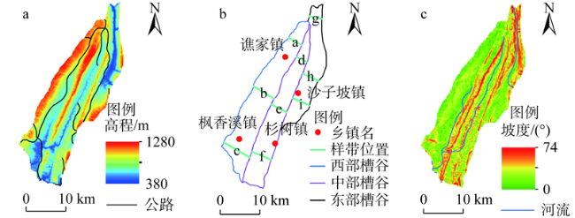
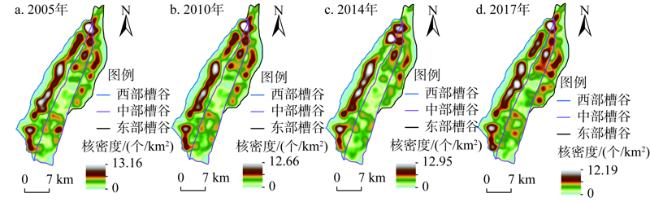
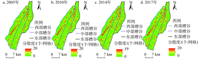
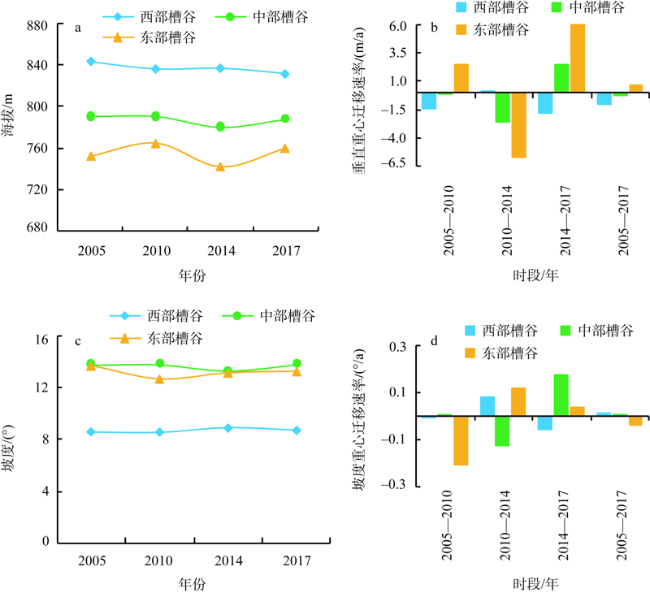
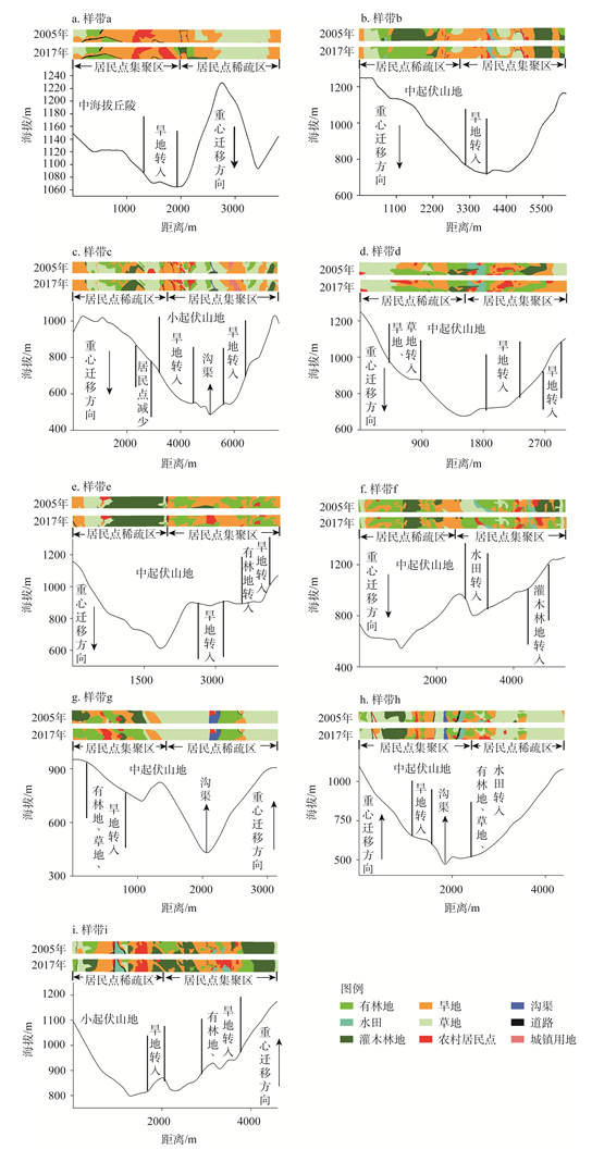
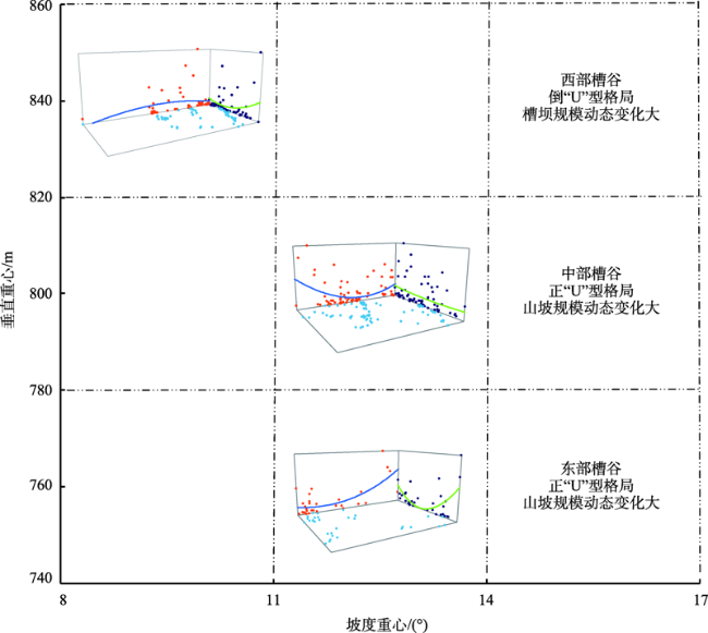
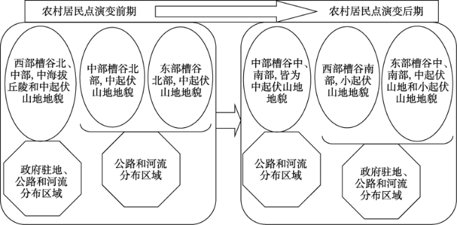
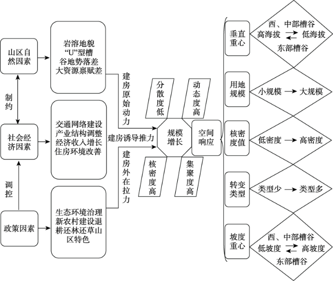
深入分析岩溶槽谷区农村居民点的时空分布特征及驱动机制,对复杂地形、经济滞后地区建设美丽新农村有重要意义。在GIS技术支持下,基于核密度、网格、重心模型、样带及地形剖面相结合的方法,以2005年、2010年、2014年和2017年槽谷区农村居民点为数据源,对其时空演变特征及其规律进行对比分析。研究表明:(1)槽谷区农村居民点呈“西部集聚组团量少规模大,而中、东部零散错落量多规模小”的空间分布模式。(2)西部槽谷农村居民点垂直和坡度重心均有向槽坝迁移的趋势,而中、东部则相反。(3)西部槽谷农村居民点布局呈槽坝高、山坡两翼低的倒“U”型格局,而中、东部则相反。(4)槽谷区农村居民点分布格局与地形间存在密切的空间响应关系。
唐芳 , 李阳兵 , 王权 , 刘秀明 , 王世杰 . 岩溶槽谷区农村居民点的时空分布特征及其驱动机制[J]. 自然资源学报, 2021 , 36(4) : 978 -977 . DOI: 10.31497/zrzyxb.20210413
The in-depth analysis of the spatial and temporal distribution characteristics and driving mechanism of rural settlements in the karst trough valley area is of great significance for the construction of beautiful new countryside in complex terrain and economically lagging areas. This study, with the support of GIS technology, combined kernel density method, grid method, center-of-gravity model, transect and terrain profile, and used the data from rural settlements in trough valley areas covering years of 2005, 2010, 2014 and 2017, to conduct a comparative analysis of the spatio-temporal evolution characteristics of rural settlements in the study area. The results show that: (1) The rural settlements in trough valleys show a spatial distribution pattern of "small clusters and large scales in the western trough valleys, and large and small scales in the central and eastern trough valleys". (2) The rural residential areas in the western troughs have a tendency to migrate to the trough dam vertically, while the central and eastern troughs are opposite. The terrain of the rural residential areas is: eastern trough valleys > central trough valleys > western trough valleys. (3) The rural residential areas in the western trough valleys present an inverted "U"-shaped distribution pattern with large trough dam heights and low slopes on both sides of the hillside, while the central and eastern trough valleys are opposite. (4) There is a close spatial response relationship between the distribution pattern of rural settlements in the trough valley area and the terrains.
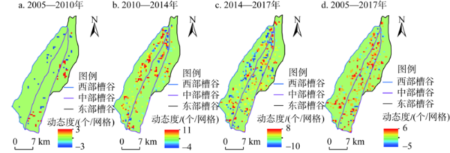
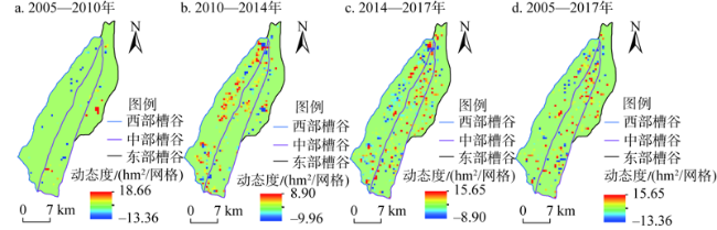
图4 基于500 m×500 m网格单元农村居民点斑块数量动态变化空间分布Fig. 4 Spatial distribution of dynamic changes of plaques in rural settlements based on 500 m×500 m grid units |
| [1] |
任平, 洪步庭, 周介铭. 基于空间自相关模型的农村居民点时空演变格局与特征研究. 长江流域资源与环境, 2015,24(12):1993-2002.
[
|
| [2] |
刘继来, 刘彦随, 李裕瑞, 等. 2007—2015年中国农村居民点用地与农村人口时空耦合关系. 自然资源学报, 2018,33(11):1861-1871.
[
|
| [3] |
原野, 赵中秋, 师学义, 等. 基于乡镇地域主导功能定位的农村居民点整理策略研究. 自然资源学报, 2017,32(12):2089-2099.
[
|
| [4] |
李换换, 宋伟, 陈百明, 等. 农村居民点时空格局演化模拟研究综述. 中国农业资源与区划, 2019,40(1):79-88.
[
|
| [5] |
臧玉珠, 刘彦随, 杨园园. 山区县域土地利用格局变化及其地形梯度效应: 以井冈山市为例. 自然资源学报, 2019,34(7):1391-1404.
[
|
| [6] |
周蕾, 熊礼阳, 王一晴, 等. 中国贫困县空间格局与地形的空间耦合关系. 经济地理, 2017,37(10):157-166.
[
|
| [7] |
刘彦随, 周扬, 刘继来. 中国农村贫困化地域分异特征及其精准扶贫策略. 中国科学院院刊, 2016,31(3):269-278.
[
|
| [8] |
|
| [9] |
|
| [10] |
|
| [11] |
周海涛, 宁小莉, 那晓东, 等. 包头市达茂旗居民点空间分布变化及其影响因素分析. 农业工程学报, 2019,35(11):276-286.
[
|
| [12] |
宋文, 吴克宁, 刘浩然, 等. 基于地理空间适宜性指数自相关的农村居民点整理分区. 农业工程学报, 2016,32(19):249-257.
[
|
| [13] |
程荣, 段永红, 王萍. 兖州矿区农村居民点景观格局变化分析. 山西农业大学学报: 自然科学版, 2019,39(3):50-57.
[
|
| [14] |
邹利林, 王建英. 中国农村居民点布局优化研究综述. 中国人口·资源与环境, 2015,25(4):59-68.
[
|
| [15] |
殷嘉迪, 雷国平, 乐容潮, 等. 三江平原农村居民点时空格局演变: 以富锦市为例. 水土保持研究, 2017,24(6):300-312.
[
|
| [16] |
包颖, 王三, 刘秀华. 丘陵区农村居民点时空格局演变及其整治分析: 以重庆市北碚区为例. 西南大学学报: 自然科学版, 2017,39(8):108-115.
[
|
| [17] |
党国锋, 李艳玫. 山区农村居民点的空间格局差异研究: 以陇南市文县为例. 中国农学通报, 2017,33(23):147-156.
[
|
| [18] |
|
| [19] |
乐容潮, 雷国平, 殷嘉迪, 等. 农村居民点空间分布及影响因素分析: 以庆安县为例. 中国农业大学学报, 2017,22(11):173-180.
[
|
| [20] |
冯佰香, 李加林, 何改丽, 等. 农村居民点时空变化特征及驱动力分析: 以宁波市北仑区为例. 生态学杂志, 2018,37(2):523-533.
[
|
| [21] |
贺艳华, 曾山山, 唐承丽, 等. 中国中部地区农村聚居分异特征及形成机制. 地理学报, 2013,68(12):1643-1656.
[
|
| [22] |
王权, 李阳兵, 刘亚香. 岩溶槽谷区山坡—槽坝土地利用变化的对比研究. 长江流域资源与环境, 2019,28(1):122-133.
[
|
| [23] |
杨忍, 刘彦随, 龙花楼, 等. 基于格网的农村居民点用地时空特征及空间指向性的地理要素识别: 以环渤海地区为例. 地理研究, 2015,34(6):1077-1087.
[
|
| [24] |
刘彦随, 杨忍. 中国县域城镇化的空间特征与形成机理. 地理学报, 2012,67(8):1011-1020.
[
|
| [25] |
周启刚, 陈丹, 陈倩. 重庆山地都市区1985—2010年土地利用重心迁移研究. 水土保持研究, 2013,20(4):189-193.
[
|
| [26] |
李骞国, 石培基, 刘春芳, 等. 黄土丘陵区乡村聚落时空演变特征及格局优化: 以七里河区为例. 经济地理, 2015,35(1):126-133.
[
|
| [27] |
刘锐, 胡伟平, 王红亮, 等. 基于核密度估计的广佛都市区路网演变分析. 地理科学, 2011,31(1):81-86.
[
|
| [28] |
李阳兵, 李睿康, 罗光杰, 等. 贵州典型峰丛洼地区域近50年村落演变规律及驱动机制. 生态学报, 2018,38(7):2523-2535.
[
|
| [29] |
|
| [30] |
|
| [31] |
姜转芳, 颉耀文, 李汝嫣, 等. 基于GIS的干旱区绿洲农村居民点格局演变研究: 以甘肃河西地区为例. 生态与农村环境学报, 2019,35(3):324-331.
[
|
| [32] |
王权, 李阳兵, 刘亚香, 等. 基于地形梯度的岩溶槽谷区土地利用空间格局分析. 生态学报, 2019,39(21):7866-7880.
[
|
| [33] |
杨勇, 邓祥征, 吴锋, 等. 华北平原农村居民点演变及社会经济影响因素分析. 人文地理, 2019,34(2):116-124.
[
|
| [34] |
|
/
| 〈 |
|
〉 |