
干旱区绿洲城镇扩张对耕地空间影响及预测——以河西走廊区域为例
|
孙钦珂(1995- ),男,山东济宁人,硕士,研究方向为城市遥感。E-mail: qksun2018@163.com |
收稿日期: 2019-11-08
要求修回日期: 2020-02-19
网络出版日期: 2021-06-28
基金资助
国家自然科学基金项目(41701173)
国家自然科学基金项目(41961027)
教育部人文社会科学研究青年基金项目(17YJCZH268)
版权
Spatial influence and prediction of oasis urban expansion on cultivated land in arid areas: A case study of the Hexi Corridor
Received date: 2019-11-08
Request revised date: 2020-02-19
Online published: 2021-06-28
Copyright
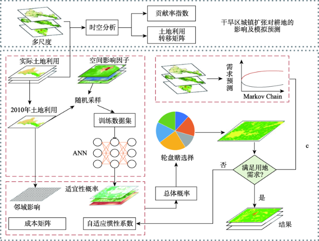
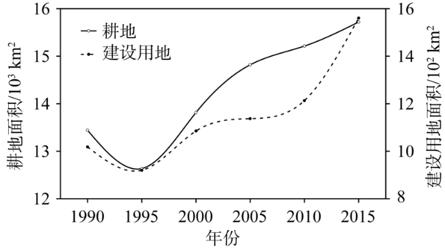
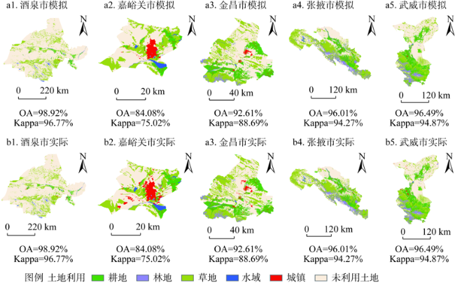
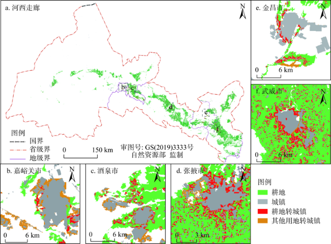
绿洲城镇是干旱地区人类活动最剧烈、人口集聚度最高、“人—地”关系矛盾最为突出的生态环境脆弱区。受全球气候变化影响及西部大开发战略推动,区域城镇与绿洲耕地之间的动态变化及利弊权衡成为当前关注的热点。基于1990—2015年多时相遥感影像数据,以典型绿洲城镇河西走廊为研究区,引入Markov和ANN-CA模型对河西走廊城镇用地与耕地的时空动态转换特征与规律展开探索,揭示了城镇扩张对耕地的影响过程与机制。研究结果表明:(1)河西走廊土地总体以未利用土地和草地为主,城镇用地与耕地仅占区域总面积的0.63%、6.35%,且城镇与耕地面积共同经历了先减少后增加的“V”型变化趋势。(2)1990—2015年河西走廊城镇面积扩张了1.53倍,其中15.67%的城镇扩张用地来自耕地占用,其他主要来源于草地,沙漠和戈壁等未利用土地。另外,区域内5个地市城镇扩张的耕地占用差异较大。(3)结合Markov与ANN-CA模型的模拟和预测结果表明,2015—2030年河西走廊79.77%的城镇扩张用地将来源于周边耕地,且城镇空间扩张方式以外延扩展为主,未来耕地被城镇侵占压力较大。研究结果将为干旱区相似区域空间规划和耕地保护提供决策支持。
孙钦珂 , 周亮 , 唐相龙 , 孙东琪 , 党雪薇 . 干旱区绿洲城镇扩张对耕地空间影响及预测——以河西走廊区域为例[J]. 自然资源学报, 2021 , 36(4) : 1008 -1020 . DOI: 10.31497/zrzyxb.20210415
Oasis city and town is a fragile ecological environment area with the most densely population, the most intense human activities and the most prominent contradiction between human and land in arid regions. Affected by global climate change and China's western development strategy, the dynamic changes between regional towns and oasis cultivated land and the trade-offs between them have become the hotspots of current concern. Based on the multi-temporal remote sensing land use data from 1990 to 2015, this paper takes the oasis cities and towns of the Hexi Corridor, a typical arid area as the research region, introduces Markov and ANN-CA models to deeply explore the land change process, quantifies the temporal and spatial dynamic transformation of urban land and cultivated land, and reveals the process and mechanism of urban expansion from cultivated land. The results show that: (1) The land types in Hexi are mainly unused land and grassland, and the urban and cultivated land accounted for 0.63% and 6.35%, respectively. The urban land and cultivated land areas showed a V-shaped change trend of first decrease and then increase. (2) From 1990 to 2015, the urban area of the expanded by 1.53 times, of which 15.67% was converted from cultivated land, and the others were mainly from unused land such as grasslands, deserts, and Gobi. The proportions of cultivated land occupied by urban expansion in five cities were quite different. (3) The simulation and prediction results combined with the Markov and ANN-CA models show that 79.77% of urban expansion land will come from cultivated land in 2015-2030, and the mode of urban spatial expansion is mainly extended. In addition, the pressure on cultivated land occupied by urban expansion will be greater in the future. The results will provide decision making support for future urban development planning and cultivated land protection.
表1 2015年河西走廊土地利用类型统计表Table 1 Statistical table of land use types of Hexi Corridor in 2015 (%) |
| 区域名称 | 耕地 | 林地 | 草地 | 水域 | 建设用地 | 未利用土地 |
|---|---|---|---|---|---|---|
| 酒泉市 | 2.05 | 0.43 | 16.51 | 0.93 | 0.26 | 79.82 |
| 嘉峪关市 | 9.15 | 0.73 | 25.90 | 2.86 | 9.74 | 51.62 |
| 金昌市 | 17.72 | 2.89 | 27.66 | 0.74 | 2.68 | 48.31 |
| 张掖市 | 11.59 | 10.24 | 38.07 | 2.28 | 1.09 | 36.73 |
| 武威市 | 19.64 | 7.67 | 26.17 | 0.31 | 1.19 | 45.02 |
| 河西走廊 | 6.35 | 2.98 | 21.52 | 1.06 | 0.63 | 67.44 |
表2 不同高程区间内的土地利用类型分布特征Table 2 Distribution of land use types under different elevation classifications |
| 等级 | 高程/m | 耕地/% | 林地/% | 草地/% | 水域/% | 建设用地/% | 未利用土地/% |
|---|---|---|---|---|---|---|---|
| 1 | <1500 | 8.59 | 0.92 | 11.78 | 0.72 | 0.68 | 77.31 |
| 2 | 1500~2000 | 6.44 | 0.27 | 14.13 | 0.41 | 1.00 | 77.74 |
| 3 | 2000~2900 | 10.85 | 3.58 | 35.77 | 1.04 | 0.80 | 47.96 |
| 4 | 2900~3500 | 0.72 | 16.63 | 34.05 | 0.39 | 0.04 | 48.18 |
| 5 | 3500~4000 | 0 | 5.56 | 40.44 | 0.87 | 0.01 | 53.12 |
| 6 | >4000 | 0 | 0.47 | 24.46 | 6.57 | 0 | 68.49 |
表3 1990—2015年河西走廊及各市耕地对城镇扩张的贡献率Table 3 Contribution rate of cultivated land to urban expansion in Hexi Corridor and various cities from 1990 to 2015 (%) |
| 区域名称 | CR | ||||
|---|---|---|---|---|---|
| 1990—2000年 | 2000—2005年 | 2005—2010年 | 2010—2015年 | 1990—2015年 | |
| 酒泉市 | 26.39 | 24.36 | -14.75 | 3.27 | -2.93 |
| 嘉峪关市 | -0.93 | 0.57 | -18.83 | 0.00 | -2.11 |
| 金昌市 | -3.59 | 3.73 | 18.00 | 4.95 | -0.09 |
| 张掖市 | 72.36 | 31.40 | 10.15 | 19.66 | 29.09 |
| 武威市 | 98.00 | 71.78 | 84.33 | 37.80 | 52.87 |
| 河西走廊 | 64.77 | 22.53 | -7.12 | 15.02 | 15.67 |
注:“-”表示城镇建设用地向耕地的转化。1990—1995年间城镇和耕地的面积均没有增加,因此计算1990—2000年的CR。 |
| [1] |
|
| [2] |
张增祥, 汪潇, 温庆可, 等. 土地资源遥感应用研究进展. 遥感学报, 2016,20(5):1243-1258.
[
|
| [3] |
|
| [4] |
龙花楼, 曲艺, 屠爽爽, 等. 城镇化背景下中国农区土地利用转型及其环境效应研究: 进展与展望. 地球科学进展, 2018,33(5):455-463.
[
|
| [5] |
赵晓丽, 张增祥, 汪潇, 等. 中国近30 a耕地变化时空特征及其主要原因分析. 农业工程学报, 2014,30(3):1-11.
[
|
| [6] |
|
| [7] |
赵雪雁, 刘江华, 王蓉, 等. 基于市域尺度的中国化肥施用与粮食产量的时空耦合关系. 自然资源学报, 2019,34(7):1471-1482.
[
|
| [8] |
王岱, 孙鸣喆, 蔺雪芹, 等. 可持续发展指向下的北京农业发展系统评价与模式分析. 中国科学院大学学报, 2014,31(6):745-752.
[
|
| [9] |
|
| [10] |
郝庆, 邓玲, 封志明. 国土空间规划中的承载力反思: 概念、理论与实践. 自然资源学报, 2019,34(10):2073-2086.
[
|
| [11] |
安成邦, 王伟, 段阜涛, 等. 亚洲中部干旱区丝绸之路沿线环境演化与东西方文化交流. 地理学报, 2017,72(5):875-891.
[
|
| [12] |
周亮, 朱彦儒, 孙东琪. 河西走廊城乡居名点空间分异特征及履职孕育度分析. 干旱区地理, 2020,43(1):227-236.
[
|
| [13] |
潘竟虎, 张建辉, 胡艳兴. 近20 a来甘肃省县域人均粮食占有量时空格局及其驱动力研究. 自然资源学报, 2016,31(1):124-134.
[
|
| [14] |
张小雷, 杜宏茹. 中国干旱区城镇化发展现状及新型城镇化路径选择. 中国科学院院刊, 2013, (1):46-53.
[
|
| [15] |
周亮, 车磊, 周成虎. 中国城市绿色发展效率时空演变特征及影响因素. 地理学报, 2019,74(10):2027-2044.
[
|
| [16] |
|
| [17] |
邓祥征. 中国西部城镇化可持续发展路径的探讨. 中国人口·资源与环境, 2013,23(10):24-30.
[
|
| [18] |
朱会义, 李义. 西北干旱区耕地扩张原因的实证分析. 地理科学进展, 2011,30(5):615-620.
[
|
| [19] |
|
| [20] |
吴文婕, 石培基, 胡巍. 干旱区绿洲城市化发展与耕地保护协同性分析: 以张掖市甘州区为例. 地理科学进展, 2011,30(5):621-626.
[
|
| [21] |
|
| [22] |
何春阳, 史培军, 陈晋, 等. 基于系统动力学模型和元胞自动机模型的土地利用情景模型研究. 中国科学: D辑: 地球科学, 2005,35(5):464-473.
[
|
| [23] |
黎夏. 地理模拟系统: 元胞自动机与多智能体 北京: 科学出版社, 2007.
[
|
| [24] |
肖琳, 田光进, 乔治. 基于Agent的城市扩张占用耕地动态模型及模拟. 自然资源学报, 2014,29(3):516-527.
[
|
| [25] |
|
| [26] |
|
| [27] |
刘纪远, 匡文慧, 张增祥, 等. 20世纪80年代末以来中国土地利用变化的基本特征与空间格局. 地理学报, 2014,69(1):3-13.
[
|
| [28] |
徐新良, 刘纪远, 张增祥, 等. 中国5年间隔陆地生态系统空间分布数据集(1990—2010)内容与研发. 全球变化数据学报, 2017,1(1):52-59.
[
|
| [29] |
徐新良. 中国人口空间分布公里网格数据集. 中国科学院资源环境科学数据中心注册与出版系统, http://www.resdc.cn/DOI 2017, Doi: 10.12078/2017121101.
[
|
| [30] |
徐新良. 中国GDP空间分布公里网格数据集. 中国科学院资源环境科学数据中心注册与出版系统, http://www.resdc.cn/DOI 2017, Doi: 10.12078/2017121102.
[
|
| [31] |
李俊, 董锁成, 李宇, 等. 宁蒙沿黄地带城镇用地扩展驱动力分析与情景模拟. 自然资源学报, 2015,30(9):1472-1485.
[
|
| [32] |
|
| [33] |
周成虎, 欧阳, 马廷, 等. 地理系统模拟的CA模型理论探讨. 地理科学进展, 2009,28(6):833-838.
[
|
| [34] |
杨俊, 张永恒, 葛全胜, 等. 基于GA-MCE算法的不规则邻域CA土地利用模拟. 地理研究, 2016,35(7):1288-1300.
[
|
| [35] |
|
/
| 〈 |
|
〉 |