
OBIA与RF结合的龙口市土地利用信息提取方法
作者简介:王瑷玲(1972- ),女,山东临沂人,博士,教授,研究方向为土地利用与评价。E-mail: ailingwang@sdau.edu.cn
收稿日期: 2018-08-22
要求修回日期: 2019-01-17
网络出版日期: 2019-04-20
基金资助
山东省重点研发计划项目(2017CXGC0308)
山东省博士后创新项目(222016)
The extraction approach of land use information combining OBIA with RF in Longkou city
Received date: 2018-08-22
Request revised date: 2019-01-17
Online published: 2019-04-20
Copyright
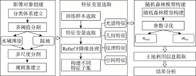
为提高中分辨率遥感影像解译精度,本文提出面向对象影像分析(Object Based Image Analysis,OBIA)与随机森林(Random Forest,RF)结合的土地利用信息提取方法。采用Landsat 8 OLI影像,针对不同地物特点,阈值分割和多尺度分割结合创建影像对象,规则集和分类器协同分类,基于Relief F算法分别对光谱特征、纹理特征及所有特征降维筛选特征子集,并与全部特征一起应用RF建模,对龙口市进行土地利用信息提取与比较。结果表明:OBIA与RF结合提取土地利用信息,基于Relief F算法筛选纹理特征,保留完整光谱、几何、空间关系特征构建RF模型,建模错分率为0.0958,分类总体精度和Kappa系数分别为89.37%和0.872,取得较理想结果。该方法可应用于中分辨率遥感影像土地利用信息提取。
王瑷玲 , 张校千 , 苏晨晨 , 于新洋 . OBIA与RF结合的龙口市土地利用信息提取方法[J]. 自然资源学报, 2019 , 34(4) : 707 -717 . DOI: 10.31497/zrzyxb.20190403
In order to improve the interpretation precision of the medium resolution satellite image, this paper proposed a new extraction approach of land use information combining Object Based Image Analysis (OBIA) with Random Forest (RF). Using the Landsat 8 OLI image and according to the features of all kinds of ground objects, the image objects were created combined with the multi-threshold and multi-resolution segmentation method, and the rule set and classifier were collaboratively used in the image classification. The Relief F algorithm was used to dimensionally reduce the spectral, texture and all feature variables, and to select 3 feature subsets. Then the RF model was conducted with the 3 feature subsets and all feature subset to build 4 models. The 4 models were applied to extract land use information in Longkou city, and the results were compared. The result indicated that the OOB (Out of Bag) misclassification, classification accuracy and Kappa index were 0.0958, 89.37% and 0.872 respectively with the land use information extraction approach combining OBIA with RF, dimension reduction based on the Relief F algorithm only for texture features. This retained the complete spectral, geometric and spatial features, which has a higher accuracy. The approach can be applied to the extraction of land use information with the medium resolution satellite image.
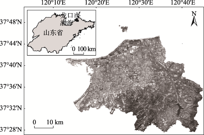
Fig. 1 Location of the study area (The red band of Landsat 8 OLI)图1 研究区位置图(Landsat 8 OLI红波段) |
Fig. 2 Technical workflow图2 技术路线 |
Table 1 The number of samples for each land use type(单位:个)表1 各地类样点像元数量 |
| 地类 | 城乡建设用地 | 耕地 | 林地 | 草地 | 园地 | 交通用地 | 未利用地及其他 | 总计 |
|---|---|---|---|---|---|---|---|---|
| 训练样本 | 33118 | 30717 | 57932 | 16826 | 47798 | 4089 | 12567 | 192913 |
| 验证样本 | 16488 | 15366 | 28949 | 8412 | 22291 | 2032 | 6293 | 93173 |
Table 2 Feature variables and their number表2 特征变量及编号 |
| 特征类别 | 特征变量及编号 | 合计/个 |
|---|---|---|
| 光谱特征 | 1~9:2~6波段均值、MNDWI、NDVI、光谱最大差分Max. Diff 10~20:2~6波段方差、MNDWI方差、NDVI方差、TC 1~TC 3方差 21~23:TC 1~TC 3均值:Brightness、Wetness、Greenness | 23 |
| 几何特征 | 1~8:面积、边界指数、紧致度、长宽比、对称性、密度、矩形拟合度、形状指数 | 8 |
| 纹理特征 | 1~40:GLCM Ang. 2nd moment、GLCM Mean、GLCM Dissimilarity、GLCM Contrast、GLCM Homogeneity、GLCM Entropy、GLCM Correlation、GLCM StdDev (all dir.、0°、45°、90°、135°) 41~60:GLDV Ang. 2nd moment、GLDV Contrast、GLDV Entropy、GLDV Mean (all dir.、0°、45°、90°、135°) | 60 |
| 空间特征 | 1~3:5、6 波段和NDVI对象邻域的平均差分(绝对值) | 3 |
注:GLCM为灰度共生矩阵、GLDV为灰度差分矢量、And. 2nd moment为二阶矩、Mean为均值、Homogeneity为同质性、Dissimilarity为差异性、Entropy为熵、Correlation为相关性、Contrast为对比度、Entropy为熵、StdDev为方差。 |
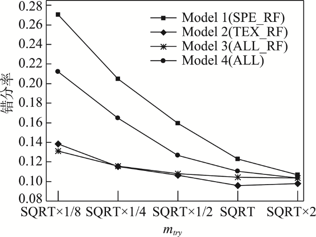
Fig. 3 The relationship between the number of features and the OOB misclassification图3 特征数量与错分率关系 |
Table 3 The range of the optimal parameters表3 最优参数范围 |
| 参数 | Model 1 | Model 2 | Model 3 | Model 4 |
|---|---|---|---|---|
| ntree | (1,2,4,9,18) | (1,2,4,7,11) | (1,2,4,7,11) | (1,2,4,10,19) |
| mtry | (135,140,145) | (138,148,158) | (137,144,151) | (140,150,160) |
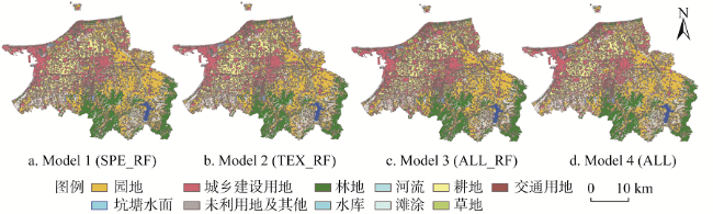
Fig. 4 The classification result of different models图4 不同模型分类结果 |
Table 4 The execution time, OOB misclassification and classification accuracy of different models表4 不同模型执行时间、OOB错分率和分类精度 |
| 分类模型 | 算法执行时间 | OOB错分率 | 总体精度/% | Kappa系数 |
|---|---|---|---|---|
| Model 1(SPE_RF) | 42 m 34 s | 0.1075 | 84.93 | 0.818 |
| Model 2(TEX_RF) | 39 m 49 s | 0.0958 | 89.37 | 0.872 |
| Model 3(ALL_RF) | 38 m 32 s | 0.1026 | 87.52 | 0.849 |
| Model 4(ALL) | 47 m 21 s | 0.1028 | 87.16 | 0.845 |
Table 5 Confusion matrix of classification result(%)表5 分类结果混淆矩阵 |
| 地物 类别 | 坑塘 水面 | 滩涂 | 草地 | 园地 | 耕地 | 未利用地及其他 | 林地 | 城乡建设用地 | 交通 用地 | 河流 | 水库 水面 | 未分类 | 用户 精度 | |||||||
|---|---|---|---|---|---|---|---|---|---|---|---|---|---|---|---|---|---|---|---|---|
| 坑塘水面 | 100 | 6.34 | 0 | 0 | 0 | 0 | 0 | 0 | 0 | 0 | 0 | 0 | 2.01 | |||||||
| 滩涂 | 0 | 61.77 | 0 | 0 | 0 | 0 | 0 | 0 | 0 | 0 | 0 | 0 | 2.69 | |||||||
| 草地 | 0 | 1.39 | 76.44 | 4.33 | 3.41 | 0 | 0 | 0 | 0 | 0 | 0 | 0 | 7.83 | |||||||
| 园地 | 0 | 0 | 18.40 | 89.57 | 3.73 | 3.83 | 2.55 | 0 | 0 | 0 | 0 | 0 | 20.74 | |||||||
| 耕地 | 0 | 0 | 4.33 | 1.88 | 86.45 | 1.16 | 0 | 0.31 | 0 | 0 | 0 | 0 | 14.30 | |||||||
| 未利用地 及其他 | 0 | 22.61 | 0 | 0 | 6.41 | 75.10 | 0.76 | 2.24 | 0 | 0 | 0 | 0 | 5.85 | |||||||
| 林地 | 0 | 1.00 | 0.31 | 3.62 | 0 | 1.43 | 96.59 | 0 | 0 | 0 | 0 | 0 | 26.93 | |||||||
| 城乡建设 用地 | 0 | 1.52 | 0 | 0 | 0 | 17.64 | 0 | 92.72 | 8.61 | 0 | 0 | 0 | 15.34 | |||||||
| 交通用地 | 0 | 4.29 | 0.52 | 0.60 | 0 | 0.84 | 0.09 | 4.73 | 91.39 | 0 | 0 | 0 | 1.89 | |||||||
| 河流 | 0 | 0 | 0 | 0 | 0 | 0 | 0 | 0 | 0 | 100 | 0 | 0 | 0.85 | |||||||
| 水库水面 | 0 | 1.07 | 0 | 0 | 0 | 0 | 0 | 0 | 0 | 0 | 100 | 0 | 1.58 | |||||||
| 未分类 | 0 | 0 | 0 | 0 | 0 | 0 | 0 | 0 | 0 | 0 | 0 | 0 | 0 | |||||||
| 生产者 精度 | 100 | 61.77 | 76.44 | 89.57 | 86.45 | 75.10 | 96.59 | 92.72 | 91.39 | 100 | 100 | |||||||||
Table 6 Land area statistics of Longkou city in 2014表6 2014年龙口市各地类面积统计 |
| 地类 | 耕地 | 园地 | 林地 | 草地 | 城乡建设用地 | 交通 用地 | 滩涂 | 河流 | 坑塘 水面 | 水库 | 未利用地 及其他 |
|---|---|---|---|---|---|---|---|---|---|---|---|
| 面积/hm2 | 17311.67 | 24079.97 | 14134.58 | 2568.03 | 17361.74 | 3577.91 | 1074.27 | 152.49 | 729.04 | 576.46 | 8538.84 |
| 比例/% | 19.21 | 26.72 | 15.69 | 2.85 | 19.27 | 3.97 | 1.19 | 0.17 | 0.81 | 0.64 | 9.48 |
The authors have declared that no competing interests exist.
| [1] |
[
|
| [2] |
|
| [3] |
[
|
| [4] |
[
|
| [5] |
[
|
| [6] |
[
|
| [7] |
|
| [8] |
|
| [9] |
[
|
| [10] |
[
|
| [11] |
[
|
| [12] |
|
| [13] |
[
|
| [14] |
|
| [15] |
[
|
| [16] |
[
|
| [17] |
[
|
| [18] |
|
| [19] |
[
|
| [20] |
|
| [21] |
|
| [22] |
[
|
| [23] |
[
|
| [24] |
|
/
| 〈 |
|
〉 |