Accurate identification of high-quality development level of resource-based city economy is not only conducive to the transformation of urban economic structure, but also conducive to the sustainable utilization of resources. Based on speed, efficiency and production theory, this paper divides the high-quality economic development stages of resource-based cities. The panel smooth transformation (PSTR) model is used to identify the high-quality economic development level of 30 coal cities in China from 2003 to 2020, and further analyzes the transformation rules. The results show that: First, the high-quality economic development level of resource-based cities is highly correlated with the intensity of resource industry, and has obvious stage characteristics. Second, from 2003 to 2011, the number of coal cities at the high and medium level of high-quality economic decelopment increased from 12 to 19, and that at the low level decreased from 18 to 11. This indicates that most coal cities improved the high-quality economic development level. Third, the high-quality economic development of 11 coal cities has realized the single-stage transition, only Wuhai city has achieved the transition from low to high level, and the remaining 18 coal cities are in stagnation. Further, the driving mechanism analysis shows that industrial structure upgrading is an important factor to promote the transition of high-quality economic development stage in coal cities. It indicates that the improvement of high-quality economic development level of coal cities is a long-term process, which requires continuous promotion of economic transformation.
According to the comprehensive efficiency of multiple input factors in the evaluation of tourism resource efficiency, which cannot separate the output efficiency of a single input factor, in the perspective of tourism resource transformation efficiency, the resource transformation efficiency, its spatial differentiation characteristics and the interaction influence mechanism of the 81 typical red tourist attractions were evaluated by using the modified DEA model, spatial autocorrelation method and geographical detector model in Hunan province in 2020. The results showed that: (1) The transformation efficiency of red tourism resources in Hunan was 0.332, and it presented a spatial pattern of high in the east and low in the west. (2) Red tourism resources production efficiency and transformation efficiency of local space correlation from east to west gradually exhibited a decreasing trend. On this basis, the efficiency types of red tourism resources can be divided into five types, that is, the coordinated efficiency of production of red tourism resources, the comprehensive quality and efficiency improvement of red tourism industry, the transformation and upgrading of red tourism resources, the comprehensive production capacity improvement of red tourism resources, and the comprehensive efficiency cultivation of red tourism resources. (3) Three endogenous ability elements, namely, product innovation ability, human capital quality and tourism market scale, were the leading factors of red tourism resources in Hunan. Product innovation ability and science and technology information level, human capital quality and tourism market scale, human capital quality and economic development level were the internal and external factors leading to the spatial differentiation. The results enriched the theory of tourism efficiency research and can provide scientific reference for regulating the efficiency of red tourism resources to provide feasible development approaches and promoting the high-quality transformation and development of red tourism economy in Hunan province.
Resource-based cities are the cities that take the exploitation and processing of natural resources (minerals, forests, etc.) in the region as the leading industries (including prefecture-level cities, regions and other prefecture-level administrative regions, and county-level cities, counties and other county-level administrative units). They are important guarantees for the protection and utilization of energy resources in China and promote the sustainable development of the national economy. However, in the process of development, resource-based cities are facing problems such as resource depletion, environmental degradation, and lack of endogenous power of transformation. Therefore, promoting resource-based cities transformation and development is a key measure to accelerate the construction of ecological civilization and build a new development pattern in the new era. This study takes 19 resource-declining cities (prefecture-level cities) as the research object, and constructs an influencing factor index system of tourism transformation and development of resource-based cities, including four dimensions of ecological environment, resource environment, economic environment and cultural environment. On this basis, using the method of qualitative comparative analysis of fuzzy sets, this paper makes necessity analysis of single variable and multivariate path configuration analysis to explore the influencing factors and driving types of tourism transformation and development of resource-based cities. It is found that: (1) Environmental regulation is a single necessary condition for the transformation and development of tourism in resource-declining cities. Under the guidance of the government, effective environmental regulation can reduce the damage to the ecological environment caused by the economic growth of resource-declining cities, and then provide a good ecological environment for tourism development. (2) There are four driving types in the transformation and development of tourism in resource-declining cities: economic development driven, environment-culture driven, environment-energy-culture driven and environment-economy-culture driven models. On this basis, by comparing the core conditions of various types, we can further find that the environment and culture play a more important role in the process of tourism transformation. (3) There are four driving types leading to the transformation and development of non-tourism: environment-economy inhibition, environment-economy-culture inhibition, cultural endowment inhibition and economy-culture inhibition. It can be seen that economic development, cultural endowment and environment are the key to restricting the tourism development of resource-declining cities. From the perspective of configuration, this study combs the influencing factors and action mechanism in the process of tourism transformation in resource-declining cities, and further analyzes the driving types of "tourism transformation development" and "non-tourism transformation development". The research results not only enrich the relevant academic achievements of the transformation and development of resource-based cities, but also provide academic support and theoretical reference for their practical development.
The 'double evaluation' has become a scientific basis for constructing the spatial pattern of the national territory. The urban construction part of the current 'double evaluation' scheme is incomplete in terms of concepts, technical routes, specific methods and results application, making it difficult to guide planning practices. In response to the above issues, based on the national technical guidelines, this article takes Jiaxing city, Zhejiang province as an example, and optimizes it from three aspects: evaluation methods, index selection and evaluation application, with the following conclusions. (1) Distinguish strong restriction index and suitability index; replace the grading method with a multi-factor weighting method. (2) In the adaptability evaluation, add social and economic factors and distinguish general index system and local characteristic index system; in the carrying capacity evaluation, increase the constraint of water environment capacity to highlight the restrictiveness of water resources. (3) Integrate three applications to solve the guidance and connection problems. This article applies this optimized technical path, proving that it can effectively guide the 'double evaluation' in different types of regions to achieve intensive development, and provides a scientific and feasible technical framework that integrates multi-dimensional factors to achieve comprehensive urban 'double evaluation', which can be referenced by more urban areas in China.
The value realization of ecological products is a tough issue that needs to be solved urgently in territory spatial planning. There are many ways and means to realize the value of ecological products. Among them, the regional development unfairness, caused by the initial allocation of land development rights in different regions by territory spatial planning, should be partially corrected by ecological land compensation. This paper clarifies the institutional transformation of occupation and compensation balance from cultivated land to ecological land under the framework of territory spatial planning, tries to build a market-oriented trading mechanism of ecological products based on "Ecological Land Voucher", and takes Beijing-Tianjin-Hebei as an example. The results show that: (1) Territory spatial planning provides an institutional basis for the approval of "Ecological Land Vouchers". The transaction is to make up for the loss of land development right caused by territory spatial planning. (2) The difference between the amount of regional ecological land protection in the base year and the target year is defined as "Ecological Land Vouchers". It is proposed that the county-level local governments shall be the main body of the transaction, and the total amount of transactions shall be determined by the national annual plan management. The combination of the reserve price determined by the government and the market transaction pricing shall be adopted. (3) The ecological land is determined into four categories: forest land, grassland, wetland and water area. The area of "standard forest", after the changes of regional natural conditions, GDP and population density, is used to calculate the transaction volume of regional "Ecological Land Vouchers". (4) The case application results of the Beijing-Tianjin-Hebei Urban Agglomeration show that, from 2010 to 2018, the total demand for "Ecological land Voucher" in the Beijing-Tianjin-Hebei Region was 1420200 hm2, mainly in Haidian, Xiqing, Jinnan, Wuqing, and Changli. The total supply of "Ecological land Voucher" is 747300 hm2, mainly from Fangshan, Zhaoxian, Xinglong, Longhua, and Chengde. The research provides new ideas and relatively easy methods for the value realization of ecological products, and tries to help provide theoretical and technical support for the implementation of territory spatial planning and the protection and utilization of land resources for common prosperity.
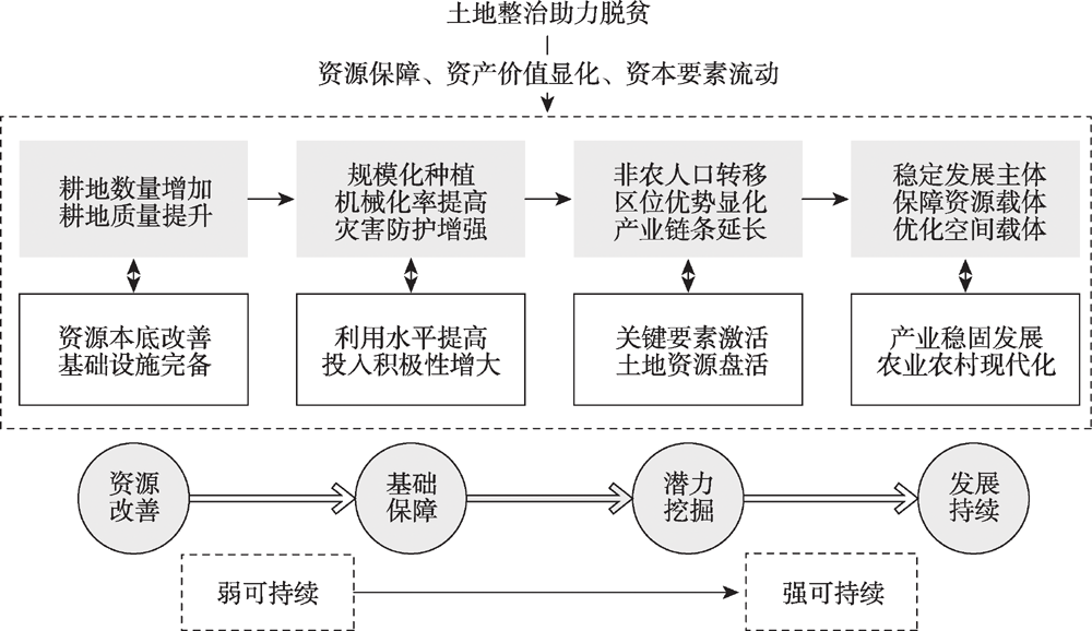
As an effective means to solve the problem of regional poverty, land consolidation plays an important role in promoting regional sustainable poverty alleviation. Regarding the extent to which land consolidation supports sustainable poverty alleviation, based on the theory of strong sustainability and weak sustainability, taking the Wumeng Mountain as the study area, we constructed the analytical framework of the poverty alleviation mechanism of land consolidation, and proposed and verified the hypothesis of land consolidation supporting poverty alleviation with the help of the structural equation model. The results showed that: (1) Land consolidation project of poverty alleviation engines produce direct benefits of total effect value of 0.72, contribute to the total effect of the indirect benefits of a value of 0.42, indicating that land consolidation can directly support the crucial direct benefits out of poverty, but the indirect benefits of regional development contribution are still inadequate. (2) The total effect value of direct benefits on indirect benefits is 0.96. The direct benefits brought by land consolidation for poverty alleviation contribute more to the indirect benefits of regional development. (3) The contribution rates of each element of land consolidation to the initial improvement degree of resources and the indirect and direct benefits are different. New cultivated land and land leveling contribute more to the initial improvement of resources, land transfer and mechanization contribute more to the direct benefits, and corporate income and tax contribute more to the indirect benefits. In order to improve the effect of land consolidation on regional poverty alleviation, it is necessary to strengthen the consolidation of direct benefits to promote the strong sustainability of indirect benefits. This study provides references for the excavation and play of land consolidation benefits, and suggestions for the comprehensive land consolidation and rural revitalization strategy in the context of territorial spatial planning.
The residential energy consumption indirect rebound effect has a wide impact but limited research. This paper estimates the indirect rebound effect of China's residential energy consumption in 2002, 2007, 2012, and 2017 using a combination of the redistribution model and the 20 sectors' environmental Input-Output table, with CO2 emission being the measure. The results show that the indirect rebound effect of residential energy consumption is between 3.90% and 12.88%. The indirect rebound effect shows an inverse U-shape across the time dimension. Besides, the urban indirect rebound effect is consistently higher than the rural indirect rebound effect. This study conducts simulations focusing on three important factors that may change under the carbon peak and carbon neutrality goals to compare their impact on the indirect rebound effect. The analyses show that the indirect rebound effect increases the most when the residential unit carbon emission expenses increase. The indirect rebound effect decreases but not as much when the backward relating coefficients decrease and is affected the least by the simulated urbanization rate. In both general policy scenario and long-term low-carbon transition scenario, the indirect rebound effect in 2030 is greater than 13%, the general policy scenario in 2060 is as high as 46.55%, and the long-term low-carbon transition scenario is 11.77%. We discussed key policy recommendations for the carbon peak and carbon neutrality goals, including pushing forward policies to transform the energy structure as well as the whole economic system, and promote low-carbon residential consumption to offset the increasing trend of indirect rebound effect.
Based on the data of 11 provincial-level regions in the Yangtze River Economic Belt (YREB), this paper uses the undesired output SBM model to measure the carbon emission efficiency of planting industry, constructs the spatial correlation network through the modified gravitational model, applies the social network analysis method to analyze the spatial correlation network structure, and uses the QAP model to examine the driving factors of the spatial correlation network. The research shows that: (1) The carbon emission efficiency of planting industry in the YREB is improved rapidly, the overall efficiency value reaches a high level, but there is still some room for improvement, and the gap still exists between provincial-level regions. Moreover, the spatial effect of the carbon emission efficiency of planting industry in the YREB breaks the traditional spatial geographical proximity and presents complex spatial network characteristics. (2) During the study period, the correlation and structure stability of the spatial nnetwork of carbon emission efficiency of planting industry in the YREB showed an overall growing trend. During this period, the spatial correlation network evolved from the unipolar dominance of Shanghai to the multi-center collaborative development pattern of Jiangsu, Zhejiang, Guizhou and Shanghai. (3) Farmer per capita income, transportation level, spatial proximity relationship, science and technology level, and government agriculture attention level have an important influence on the spatial correlation network of carbon emission efficiency of planting industry in the YREB. It is suggested that when improving the carbon emission efficiency of the planting industry in the YREB, we should consider the spatial association network structure and its driving factors, and take measures to enhance the spatial correlation of the carbon emission efficiency of the planting industry.
Photovoltaic power, affected by a variety of natural and technical factors, is an important way to achieve deep carbon reduction in energy system. But its real carbon emission reduction still needs to be accurately reevaluated. Xinjiang, where the overall natural conditions are suitable for the development of photovoltaic power generation, but the vast spatial differentiation in local geographical features is also prominent, could be no doubt chosen as a study area to conduct this research. By ways of the life cycle assessment, LCA, the power generation model and carbon emission reduction model, this paper has calculated the carbon emission, power generation and carbon emission reduction in the whole life cycle of the 1 kW multi-crystalline silicon photovoltaic power under two degradation rates (DR) in Xinjiang, so as to provide a sound scientific basis for the further development of local photovoltaic industry in the region as well as research references to other regions alike. The research results show that: (1) Compared with thermal power, the carbon emission reduction of photovoltaic power in Xinjiang reaches 863 g CO2-eq (DR=1%) or 738 g CO2-eq (DR=3%) per kilowatt-hour, accounting for 93% or 79% carbon emission of thermal power separately, which is of great significance to the decarbonization of energy system in the region. (2) The spatial differentiation of carbon emission reduction in Xinjiang is prominent, showing a spatial trend of decreasing from east to west. Clustering analysis shows that photovoltaic layout in the study area should focus on the first- and second-level areas in potential grades, such as Hami, Turpan and Bayangol. (3) The future development of photovoltaic power in Xinjiang should concentrate on the perspective of the whole lifecycle carbon reduction, improve the middle to downstream industrial chain of photovoltaic production to meet the goal of realization of full local production, and fully consider the influencing factors in the construction and operation processes, such as solar radiation, degradation rate, and reasonable layout, as well as accelerate the development of end-of-life treatment and recovery technology.

To improve grain production efficiency in the main grain production areas is an important way to increase grain output and ensure food & ecology security. Besides, it is the focus of scholars, governmens and farmers. In this paper, the Huaihe Eco-Economic Belt (HHEEB), one of the typical main grain production areas in China, is taken as the study area. The index system for grain production input, including the direct input factors from farmers and the indirect public input factors from the government, is established. the grain production efficiency (q) of 28 DMU (cities) in the HHEEB in recent 20 years was calculated with the non-radial super-SBM, and the influencing factors of spatial differences in q were analyzed by using Geodetector. There are some findings as follows: (1) The mean value of q is around 1.0, which shows that the grain production efficiency can be greatly improved in the future. (2) There is a large gap in production efficiency between different DMU, but a convergence trend is observed in the past 20 years. The changes of production efficiency are diverse, which can be divided into 7 categories and 11 sub-categories. (3) The production efficiency presented the characteristics of agglomeration and contiguous distribution, and the overall spatial pattern of q remains relatively stable. (4) The spatial difference of production efficiency is affected by many factors. Among them, annual sunshine duration, population density and agricultural modernization are the basic influencing factors driving spatial differences, furthermore, the explanatory power of other factors is different and it changes in different years.
The construction of ecological belt along the Yellow River is an important action to implement the national Yellow River development strategy. This study takes the Yellow River section in Inner Mongolia as an example, which is facing seven complex ecological problems, including the degradation of forest land, grassland and wetland, desertification, salinization, soil erosion, and obstruction of biological habitat and migration processes. We propose the theoretical framework and implementation paths for the construction of the ecological belt along the Yellow River from three aspects as integrity, systematicity and uniqueness of multidimensional composite space. At the watershed level, the environmental quality assessment of forest land, grassland and wetland and the safety assessment results of desertification, soil erosion, salinization and biological processes were superimposed to construct a comprehensive ecological security pattern of the Yellow River Basin with low, medium and high safety levels. At the river level, it was found that the area of low security pattern of the main stream of the Yellow River had the largest proportion within 10 km outside the dam and 2 km on both sides of the first tributaries, so that we can identify the composition and spatial scope of the ecological belt along the Yellow River. Finally, conservation, restoration and remediation zones are defined according to landscape characteristics of different regions.
The dwelling paradise reflects the vision of migrants and the ultimate goal of rural revitalization, as a manifestation of the human-land relationship with humanistic feelings, which can be used as a new yardstick for judging the realization degree of multiple goals for rural reconstruction. This study takes the migrants in Wuwei city, which is located at the foot of the Qilian Mountains on the northern edge of the mountain ranges, analyzes the differences in groups and spatial distribution of cultural elements and recognition evaluation of migrants' dwelling paradise on the identification framework, and uses Ordinal Logistic Regression to identify the obstacles and potential under multi-situation. The results show that: (1) In Wuwei city, migrants are primarily non-agricultural households and fatalists. Their main livelihood is migrant work. Income composition varies greatly among migrants of different types. (2) Expectations and standards of a dwelling paradise are diversified. The elements of migrants' paradise are centered around the family, village construction, income, opportunity, agriculture and government guarantees. A total of 54.8% of migrants believed that their current resettlement place met their inner expectations of living in a paradise. Recognition scores for dwelling paradise in Gulang county, relocated households, agricultural part-time households and autonomyists are the highest. (3) Influencing factors include the total annual income of the family, the length of residence, the ratio of minor dependents, the multiplicity of livelihood risks, vertical economic deprivation, sense of belonging and the amount of industrial input. The last four factors are the key obstacles. (4) As the relative deprivation and relationship trust variables are introduced, the positive influence of household income increases, whereas social integration causes the positive influence to decline. With the inclusion of industrial input variables, the negative effects of the multiple livelihood risks and vertical economic deprivation are reduced. The greater the investment in government industry, the more likely migrants are to increase their recognized settlements. This study extends the perspective and analytical dimension of eco-migration rural revitalization, and might be able to support the development of differentiated models for paradise construction.
In the New Era of 'Anthropocene', the conflict between the degradation of ecosystem and the increase of human needs has become increasingly intensified. To scientifically solve this issue, we need to realize the coordination between ecosystem services (ES) and human well-being (HWB) for modern sustainable development. Firstly, this article is well conducted on the premise of the 'from cascade to coupling' new turn of ES-HWB relationship research. Taking Guangzhou as a case study, it analyses the levels and spatial structures of ES and HWB in a micro-scale way through ES value (ESV) evaluation and HWB comprehensive assessment. Then, the coupling coordination degree model is used for clarifying the phases and spatial differentiation of ES-HWB coupling. With the construction of ES-HWB coupling theoretical framework on the paradigm of coupled human and natural systems, the driving factors and pathway differences of three typical ES-HWB coupling types are divergently explored, and the coupling problems are diagnosed. The results are as follows. (1) ESVs in Guangzhou are becoming severely weakened owing to the coercing effects from the assimilated promotion of HWB. The ES-HWB coupling performs poor coordination with notable spatial trade-offs. (2) Dominant by ES, the coupling is spatially diffuse with an uncoordinated state on account of the continuous spreading of low ESV areas. Significantly, the spatial imbalance between ES supply and HWB demand emerges. (3) By means of capital flows, land use changes, scale effect and benefit allocation, the ES-HWB coupling is divergent in different development phases and supply-demand matches. It mainly contains spatial scramble-oriented low uncoordinated, spatial weak correlated-oriented antagonistic and spatial synergies-oriented high coordinated coupling. Based on the coupling problems, it is a necessity to take both ecological civilization and high quality development as guidance for relieving human-nature conflict. In such regards, ecological spaces should get rigorously protected while the quality of urban spaces improved. Moreover, the integrated management of human and natural systems is also pivotal to weaken land trade-offs and spatial gambling. With the reinforcement of ES-HWB supply-demand coupling synergies, it is conducive for the emergence of coordination of the ES-HWB open complex giant system to achieve the harmony between human and nature.
The Loess Plateau is the most fragile ecological environment and one of the most serious soil erosion areas in the world. China has implemented the Grain for Green Project and a series of ecological engineering in the Loess Plateau since 2000. They play a good role for ecosystem restoration. In order to assess the present situation, the ecological restoration degree and the ecological restoration potential in the Loess Plateau over the past 20 years, we selected ecological quality and ecosystem services to comprehensively analyze and evaluate the degree and potential of ecological restoration in this region from 2000 to 2019 by using ground and remote sensing monitoring data and model simulation. The results showed that: (1) The ecological quality was improved: Vegetation coverage and NPP showed an increasing trend. Compared with the changes from 2000 to 2009 and from 2010 to 2019, the proportion of the area with vegetation coverage and NPP continuously improved were 39.90% and 82.71%, respectively. (2) The ecosystem services improved: The areal proportion of water conservation service with continuous improvement was 15.46%, the areal proportion of soil conservation services first improved and then stabilized or first stabilized and then improved was 18.88%, the areal proportion of wind prevention and sand fixation service with continuous improvement was 6.30%. Water and soil conservation services were improved mainly in the farming-pastoral transitional zone of the gully region, while windbreak and sand-fixing service was improved mainly in the sandy and desert areas. (3) The areas with high degree of comprehensive ecological restoration accounted for 11.08%, which was mainly located in the gully region. Only a few non-restoration areas were mainly distributed in the northwest of the sandy land and desert region, accounting for 3.51%. (4) The restoration potential of vegetation coverage was 13.10%, the high value region was mainly located in the west of the gully region, and the low value region was mainly found in the southeast of the gully region and parts of the valley plain. The restoration potential of vegetation NPP is low on the whole, and the regions with greater potential are mainly located in the loess hilly-gully region.
The study on urban-rural fringe is theoretically and practically significant for urban-rural integration development and rural revitalization. Taking Nanjing as an example, this study firstly constructed a multi-dimensional identification index system, and then identified the urban-rural fringe at administrative village/community scale using the random forest model. The characteristics of land use, social economy and population of urban areas, urban-rural fringe, and rural areas, were compared and analyzed consequently. The result shows that the urban-rural fringe in Nanjing is mostly concentrated in urban periphery in a cluster or belt shape, and its distribution pattern is consistent with the planned urban hierarchy system and administrative extent of Nanjing. It is suggested that the urbanization process of new cities and towns in the urban-rural fringe should be sped up in the near future, and other villages/communities within urban-rural fringe could be considered as the preferred area for compiling village planning. The urban-rural fringe shows typical features of transition, fuzziness, and multiplicity. Transition is the essential characteristic to distinguish urban-rural fringe from urban and rural areas, while fuzziness and multiplicity make the identification of urban-rural fringe more difficult. Therefore, combining new data and new methods to establish a multi-dimensional characteristic index system will be an important direction for accurate identification and deepening research of urban-rural fringe in the new stage.
The unified survey and monitoring of natural resources is the basis of the integrated management of natural resources. For a long time, China's natural resources survey and monitoring work has been scattered in different departments, although it has accumulated rich results and experience, but there are problems such as inconsistent concepts, overlapping content, and contradictory indicators. And with the restructuring of natural resource management business and functions, it is difficult to simply continue or physically stitch together existing achievements and experiences. Under the new situation, how to guide the smooth development of unified survey and monitoring of natural resources through the reconstruction of the theoretical and technical system has become a challenge for natural resource management departments. Starting from the perspective of natural resource management, on the basis of systematically combing the development process of China's natural resources management system and survey and monitoring work, this paper summarizes the effectiveness and shortcomings of past survey and monitoring work, analyzes the relationship between management perspective and academic perspective survey and monitoring, discusses the operation pattern of unified survey and monitoring of natural resources, and further expounds the application of this pattern in specific business with arable land protection business as an example, believing that unified survey and monitoring of natural resources is the business content under the management perspective. Taking business as the main line and stereoscopic perception technology as the means is the only way to achieve real-time and business-oriented operation of natural resources survey and monitoring. This paper aims to provide theoretical support for the effective development of unified survey and monitoring of natural resources.
As the sensitive indicator of climate change, the dynamic change of glaciers and lakes is of great significance to reveal global climate change. Based on Landsat TM/ETM+/OLI and Sentinel 2A/2B MSI remote sensing images, this study obtained information on glaciers and lakes in Qinghai province to explore their dynamic changes and response to climate change over the past two decades. Qinghai possessed glaciers with a number of 3713, an area of 3643.40 km2 and ice volume of 259.63 km3, and lakes with a number of 231 and an area of 14374.56 km2 in 2020. Due to the warming and humidification of climate in 2000-2020, the number, area and ice volume of glaciers decreased by 128, 464.63 km2 (-0.60%/a) and 29.58 km3 (-0.54%/a), while the number and area of lakes increased by 27 and 2220.09 km2 (0.84%/a) in the province. The trend of glacier change was accelerated, decreasing from west to east in the study area, and the temperature rise was the main factor. Except for the Central and Northern Qaidam Basin and the Northern Tanggula Mountains, the lake area in most parts of Qinghai presented an increasing trend. Both the regional difference of precipitation and runoff from glacier meltwater led to the expansion of most lakes. Meanwhile, the evolution of individual lakes was significantly affected by the enhancement of human activities. The expansion of some lakes has posed a direct threat to the settlements, roads and grassland around the lakes, especially triggers ecological problems such as Cladophora blooms. Therefore, the monitoring and mitigation measures of potentially dangerous lakes should be strengthened in the future.