The Covid-19 lasting for years and the geopolitical and economic changes around the world have a significant impact on China's carbon neutral strategy and the protection of natural resources in the near term and future. How to combine the goals of realizing carbon neutrality and ensuring natural resource security, and put forward the security and realization strategy of natural resources from the perspective of the technical logic of carbon neutrality and the practical logic in the field of natural resources, has important practical significance and theoretical value for China. Starting from the important supporting role of natural resources in national economic and social development along with the analysis of the current practice of natural resource utilization and protection, this paper systematically reviewed some related problems of carbon neutrality and main paths to realize carbon neutrality in the field of natural resources. The author believes that the current understanding of carbon emissions has not only the uncertainty of quantitative indicators, but many other misunderstandings as well. Facing the multi-dimensions of development goals towards the years of 2030 and 2060, China needs to coordinate the rational utilization of various energy and natural resources. In order to achieve carbon neutrality in the field of natural resources, China should adhere to its own technical and practical logics, clarifying various boundaries between carbon neutrality actions, and strengthening the research on the basic theories and methods of natural resources, revealing the coupling mechanism between carbon peak and carbon neutrality (2060 goals) and energy and resources, studying and formulating the seceding path and other utilization strategies of fossil energy, enhancing applicable technologies to improve the efficiency of resource and energy utilization, exploring the potential and implementation path of carbon sink increase through forest and grass, wetland, land use and carbon sequestration, and developing the new model of systematic governance of mountains, rivers, forests, lakes, grass, sand, ice and natural resources, carrying out strategic research, simulation and early warning, dynamic assessment, method innovation and application demonstration of natural resource security oriented to the strategic goal of carbon neutrality. The author also proposes ten key strategic plans to be implemented immediately, including the action of dual control of fossil energy, the action of renewable energy exploration, the action of resource utilization and efficiency improvement, the action of increasing storage of key minerals, the action of farmland protection and restoration, the action of forest and grass expansion and conservation, the action of wetland restoration and protection, the action of land and sea coordination, the action of resource management intelligence, and the action of talent and technology innovation.
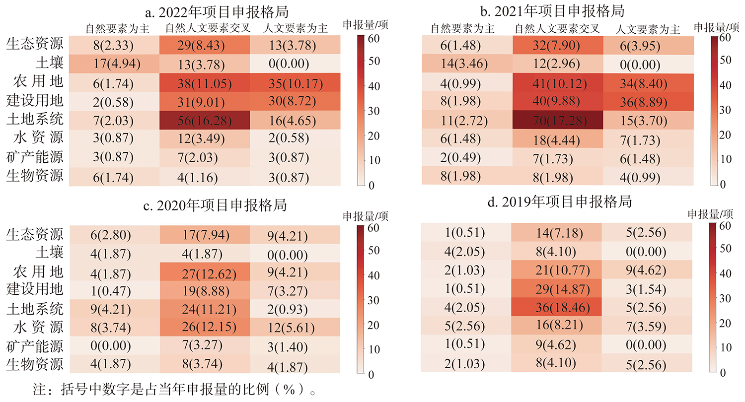
Supporting fundamental research is the responsibility and mission of the National Natural Science Foundation of China (NSFC). Natural resource management is an important research field of interdisciplinary integration and innovation in geographical sciences. This paper constructs a classification framework for research interests from the perceptive of logic and applicability, classifies relevant research interests in land sciences and natural resource management of geographical science of NSFC, analyzes the existing pattern of projects application and funding in this field, inspects the research hotspots, and proposes the development prospects of this field. Results show that: The application pattern in natural resource management since 2021 is dominated by the intersectional and human element-oriented studies, with over 55% of the intersectional category, 30% of the human element-oriented category, and around 15% of the natural element-oriented category, and from the perspective studied objects, around 73% is the land resource-oriented studies, around 14% of the ecological resource-oriented studies, and around 13% of the other natural resource-oriented studies; the funding pattern of projects is dominated by land resource studies, at more than 75%, while other natural resource funding is low in number and unstable in rate; agricultural land, construction land, and land use system are the main funding fields of land resources. To promote the healthy and sustainable development of the natural resource management research, it is necessary to innovate the research paradigm in this field, set an example of interdisciplinary integration research for geographical science, enhance its attributes of fundamental research, persist in the initial connotation of the code set, and prevent the polarization of the research pattern.
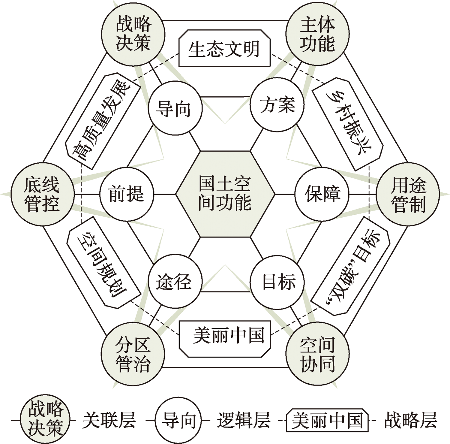
With the rapid urbanization and industrialization, China is facing many problems, such as the imbalance between urban and rural land structure, the disorder of territorial spatial development, and the regional difference. Especially, the confusion, conflict, and degradation of territorial space function are very serious, which has brought great pressure and challenges to the territorial spatial development, protection, and governance in the New Era. As an important part of the theoretical system and practical framework of structured territorial spatial planning, territorial space function referred to develop, control, and protect space according to a scheme confirmed by territorial spatial planning under the specific regional spatial scope and the human-environment interaction, with the purpose of satisfying human demands or enhancing human well-being, so as to provide utility of different products and services for human society directly or indirectly. The territorial space function was also an important scale to investigate the harmonious coexistence between human and nature. To establish the theory and reality demands of the current major strategic decisions, this paper pointed out that the regional function theory was the logical starting point of territorial space function, the theory of territorial system of human-earth interaction was the core of constructing the theory system of territorial space function, and the spatial integration was an important dimension in the evolution of the theoretical system of territorial space function. A theoretical cognitive model of territorial space function (snowflake model) was constructed from the aspects of strategic decision-making, major function, baseline control, use regulation, zoning governance and spatial coordination, in which the strategic decision-making was the policy guidance for the territorial space function, the major function was the overall plan for the spatial function pattern, the baseline control was the basic premise to realize the territorial space function, the use regulation was the institutional guarantee to strengthen the territorial space function, the zoning governance was an effective way to optimize the territorial space function, and the spatial coordination was the fundamental goal of regulating the territorial space function. Facing the needs of serving national important strategic decisions, optimizing territorial spatial development pattern and sustainable development, this paper discussed the basic problem domains of territorial space function research in the New Era, such as theoretical cognition, classification and identification, evolution mechanism and dynamic trade-off, by which a preliminary research framework of territorial space function was constructed.
The establishment of the natural resources supervision system is an important measure for the reform of China's ecological civilization system; however, this system is facing such practical difficulties as the decentralization of supervision, the overlap with the ecological environmental protection supervision system, and the limitation of the effectiveness of the supervision accountability. This paper holds that the unclear responsibilities of the departments in the field of resources and ecology, the inherent conflicts of different resource management models and the lack of the basis for supervision and regulation all contribute to the above-mentioned predicament. From the point of view of perfecting the supervisory mechanism, it is necessary not only to integrate the decentralized supervisory teams, but also to construct a central and provincial-level government supervisory system. The natural resources supervision shall be responsible for the control of natural resources, spacial planning and use, consistent with the "execution-supervision" responsibility assumed by the competent department. From the perspective of supervision by the rule of law, it is necessary to formulate the "Regulations on Natural Resources Supervision" and introduce the mechanism of co-supervision towards party and government, so as to provide normative bases for all aspects of supervision, and enhance the level of supervision accountability and deterrent effect.
Ecological red lines have cross-border conflicts and fragmentation, so it is constantly being optimized, adjusted and evaluated, but connectivity optimization and control at regional scale are still lacking. Taking the Yangtze River Delta as an example, based on the minimum cumulative resistance model and circuit theory, this paper proposes a region-scale connectivity optimization and control scheme of ecological red lines based on the data of land use, road settlements and officially issued ecological red lines, so as to provide a scientific basis for the integrated ecological protection of the study area. The results show that: (1) The ecological corridor pattern of "two horizontal and two vertical lines" in the Yangtze River Delta has been optimized, including 79 important corridors, 111 secondary corridors and 33 stepping stones; (2) There are 51 connectivity degradation risk control zones, including 12 joint prevention and control zones and 27 prevention and control zones at the edge of the source area; (3) There are 75 obstacle control areas, including 17 joint prevention and control areas and 36 border prevention and control areas of source areas; (4) There are 20 first-level control areas with an area of 70.35 km2, and 106 second-level control areas with an area of 1511.33 km2. The source and provincial administrative boundaries of the ecological protection red lines are vulnerable to degradation risks and connectivity barriers. Therefore, it is suggested that ecological corridors and stepping stones should be built at the regional scale, and joint prevention and control should be carried out in connectivity degradation risk areas and obstacle areas, as well as at the border of source areas, and graded prevention and control should be carried out in order of importance.
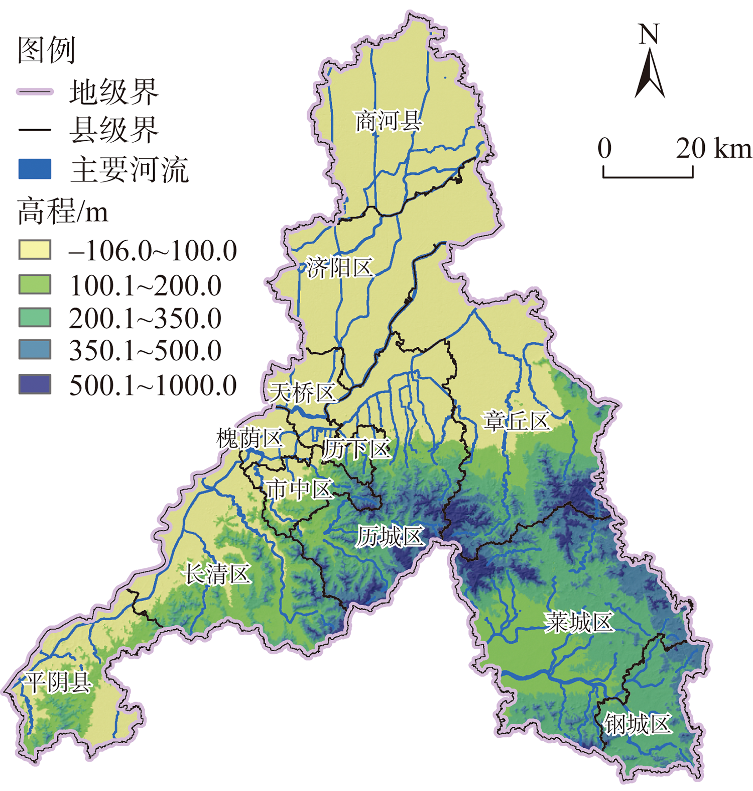
The urban development is mainly restricted by the shortage of water resources. The potential of sustainable utilization and carrying capacity of water resources are closely related to the water ecological space. Taking Jinan as an example, this research clarified the basic definition of water ecological space and water ecological protection line by comprehensively considering the systematism and integrity of water ecosystem; defined the functional attributes of water ecosystem; proposed the technical methods for identifying water ecological space and water ecological protection line, based on various water-related plans and integrating complex water ecosystem functions, and the Geographic Information System (GIS) spatial analysis technology. This research can help to protect urban water ecosystem and optimize territorial spatial pattern. The results show that the area of water ecological space in Jinan is 3307.5 km2, and the area of water ecological protection line is 1992.2 km2, accounting for only 60.2% of water ecological space. There are obvious differences between the two protection scopes. From a multi-dimensional perspective, the protection of water ecosystem presents different characteristics. Specifically, territorial space is an important part in ensuring the service function of water ecosystem; waterfront is the most vulnerable area of water ecosystem; and there is still great potential for water cultural space to be tapped. Jinan is under great pressure to protect water security and improve water environment.
High-intensity social and economic activities have caused ecological problems such as shrinking rivers, lakes and wetlands, landscape fragmentation and biodiversity loss. Therefore, the implementation of territorial space ecological restoration has become an inevitable way to realizing eco-environmental governance. In this study, we have established grid-based "Vigor-Organization-Resilience-Service" (VORS) model to evaluate ecosystem health in the middle reaches along the Yangtze River in 2010 and 2020. Based on the natural breakpoint method and intelligent correction approach, the bottom-up territorial space ecological restoration zoning was carried out, and the corresponding ecological restoration measures were proposed. The results have shown that from 2010 to 2020, the cultivated land area in the urban agglomeration in the middle reaches along the Yangtze River decreased, whereas the built-up land expanded greatly. The ecosystem health status was relatively stable, but there was obvious spatial heterogeneity. The vigor and service values improved greatly, whereas the organization and resilience values showed a downward trend. Based on the assessment result, the study area was divided into "two areas and three circles", namely, the ecosystem conservation area, the ecosystem improvement area, the ecosystem buffer circle, the ecosystem improvement circle and ecosystem remolding circle. The ecological restoration countermeasures for each area and circle were proposed.
It has great theoretical value and practical significance to clarify the relationship between carbon balance capacity and urbanization for realizing the carbon neutrality target and the development of new urbanization. The greenhouse gas inventory method, carbon absorption inventory method, carbon balance index method and multiple urbanization measurement method were used to calculate the carbon balance capacity and urbanization indicators of various types of China's provincial-level regions from 1999 to 2018 respectively. The spatial natural breakpoint classification method and Granger causality test were used to analyze the spatio-temporal evolution and interaction between China's provincial carbon balance capacity and urbanization. Furthermore, the development paths of new urbanization in different types of regions were discussed. Main conclusions are as follows: Firstly, China's provincial carbon emissions continue to increase, carbon absorption continue to decline and carbon balance capacity showed four trends, namely, increasing, decreasing, decreasing first and then increasing, and increasing first and then decreasing. The spatial distribution of carbon emissions presented a pattern of "more in the east and less in the west", and the spatial distributions of carbon absorption and carbon balance capacity were "more in the west and less in the east" and "stronger in the west and weaker in the east", respectively. Secondly, the population, economy, space, ecological urbanization and urbanization comprehensive indexes of China's provinces were increasing continuously. In addition, the spatial urbanization showed a pattern of "high in the west and low in the east", while the other types of urbanization showed "high in the east and low in the west" distribution. Thirdly, except for spatial urbanization, the relationship between carbon balance capacity and various types of urbanization was feedback type, and the provincial growth and protection type was the most, followed by the reduction and destruction type, and the neutral type was the least. The development path of China's new urbanization can be divided into four types: growth and protection type, destruction and reduction type, feedback type and neutral type. Improving regional carbon balance capacity and enhancing the development path of new urbanization had important theoretical and practical significance for realizing regional sustainable development targets. Regional differences in population, economic, social and ecological development had an influence on the realization of "dual carbon" and new urbanization goals. Therefore, in designing carbon reduction action plans, regional differences should be considered to identify carbon reduction levels and adopt differentiated measures to form carbon reduction networks.
The construction of marine ranches is an effective way to increase the ocean carbon sink and achieve the strategic goal of carbon neutrality in China. Carbon sink has obvious externality, only to determine a reasonable compensation standard to mobilize the enthusiasm of marine ranch construction operators. This paper takes economic carbon sink resources such as algae, shellfish, fish, crustacean and other species in the marine ranch as the research object, and accounted for the compensation criteria for the ecological value of carbon sink resources using an optimization model. The results indicated that the ecological compensation standards of algae, shellfish, fish, crustacean and other species were 134.94 yuan/t, 820.05 yuan/t, 782.39 yuan/t, and 3764.16 yuan/t, respectively, and there was inter-species variability in compensation standards. The results can provide a theoretical reference for optimizing the current ecological compensation policy for the marine ranch.
Inbound tourism is an important indicator of the international development of a metropolis as well as a focus of related research. Modern means are used to explore the spatial pattern and evolution of inbound tourism flows, and analyze the path and countermeasures of high-quality development and utilization of urban tourism resources by mining the digital footprint information of large samples of inbound tourism in Shanghai. It is found that: (1) The inbound tourism flows in Shanghai generally present a high concentration of centers, and the spatial density is decreasing from the core to the periphery. In the main urban areas, the inbound tourism flows cluster around CBD/RBD, core attractions, cultural and sports venues, distinctive neighborhoods and transport hubs, and stretch into patches; in the peripheral areas, they cluster around tourism attractions, with a distribution characterized by "small clustering and large dispersion". (2) The cross-regional pattern is the main spatial behavioral trajectory of inbound tourism flows in Shanghai, showing a central diffusion dominant characteristic radiating from the centre to the periphery. (3) The core and peripheral nodes of the overall network of inbound tourism flows vary greatly in terms of rank and connectivity, but over time, the scale of the network continues to expand and the structure of the network shows a continuous optimization and balanced development. (4) The rank and centrality of cultural and creative tourism nodes such as New World and Tianzifang continue to increase in the network structure, and the Expo heritage Chinese Art Palace has a significant impact on the network structure, with increasing agglomeration and diffusion functions. (5) Based on the analysis above, the paths and countermeasures are proposed for creative development and forming effective clusters relying on regional cultural resources; making full use of the influence of major events for thematic development, integrating edge nodes and regional resources to create new spaces for network growth; and strengthening the construction of public systems and linking core-edge nodes to promote the high-quality development of regional tourism. The study can provide theoretical guidance for the high-quality development of urban tourism, and give reference for the high-quality development of tourism in similar major events such as the Winter Olympics.
In this article, the ecological well-being performance of provincial-level regions in China from 2000 to 2019 is measured by using the super EBM model considering undesirable output. At the same time, with the help of the modified gravity model and social network analysis method, the evolution characteristics and formation mechanism of China's ecological well-being performance spatial correlation network are analyzed. The results show that: (1) The spatial correlation network of China's ecological well-being performance shows a spatial pattern of "dense in the east but sparse in the west". During the research period, the hierarchical network structure was gradually changed, and the associated network had a "flat" evolution trend. However, the compactness and stability of spatial association networks need to be improved. (2) The Beijing-Tianjin-Hebei region, Yangtze River Delta and Pearl River Delta are at the core of the spatial correlation network, showing obvious spillover effects, while the Northeast, Northwest and Southwest regions are located at the edge of the network. Guizhou and Gansu are the key nodes between the eastern region and the southwest and northwest provinces in the network. The transmission of ecological well-being performance among provinces is mostly realized through the mediating role of southern provinces. On the whole, the eastern coastal provinces are the "overflow highland" in the spatial correlation network, showing a significant "trickling-down effect" on the Northwest, Southwest and Northeast regions, and the benefit effect of the central provinces is not significant. (3) The results of block model analysis show that China's ecological well-being performance has significant spillover effects between provinces and regions, and the spillover effect between regions is the most important. Among them, Beijing, Tianjin and Shanghai play the role of "engine" in the correlation network, forming the net overflow plate. The Pearl River Delta and Jiangsu and Zhejiang belong to the broker plate, the middle and lower reaches of the Yangtze River and Southwest China are net overflow plates, and Northeast region, the middle and lower reaches of the Yellow River and Northwest region constitute two-way overflow plates. (4) Resource endowment difference, market regulation, government macro-control and science and technology progress are the main driving mechanisms for the evolution of spatial correlation network of ecological well-being performance in China. This study can provide an important reference for promoting the regional collaborative improvement of ecological well-being performance.
As the urbanization process accelerates, more and more urban population continues to release kinetic energy for social development. But at the same time, they bring many resource and environmental problems, intensifying the contradiction between the rapid urban development and the natural environment. Nowadays, it is inevitably an important period of in-depth development of urbanization, alleviating resource and environmental contradictions, economic transformation and upgrading, and accelerating the promotion of socialist modernization. How to achieve sustainable urban development has become a very urgent and important issue. This paper, from the perspective of Chinese characteristic administrative level, explores the impact of administrative level and city size on ecological welfare performance. This study is helpful to understand the change trend of ecological welfare performance and the formation of its heterogeneity under the "government intervention + market promotion" model. It can also provide useful policy implications for the choice of urban sustainable development strategies in China, which is of great significance to deepen sustainable development research. Based on the generalized data envelopment analysis (DEA) method and random sampling bootstrap method, using the panel data of 288 prefecture level and above cities in China from 2015 to 2018, this paper studies the impact of administrative hierarchy and urban scale on ecological well-being performance, and analyzes the path role of urban scale in the impact of administrative hierarchy on ecological well-being performance. Main conclusions are as follows: (1) 288 prefecture level and above cities in China are at overall low level of ecological well-being performance, but show an upward trend over time, and the growth rate has gradually accelerated in recent years. (2) Both administrative hierarchy and urban scale have a significant positive impact on ecological well-being performance. Technological progress significantly improves urban ecological well-being performance, and FDI dependence significantly reduces urban ecological well-being performance. (3) Urban scale is an important path for administrative hierarchy to affect ecological well-being performance. The higher administrative level will bring larger urban scale and higher level of ecological well-being performance. Finally, based on the above conclusions, policy suggestions are provided for coordinating the sustainable development of economy, environment and society.
Accurately assessing China's forest carbon sequestration potential and the cost of increasing carbon sequestration serves as the basis for carbon neutrality forestry action plans and forestry sequestration policies. In spite of the fact that there have been numerous studies conducted on the potential for forest carbon sequestration in China, as well as the costs associated with increasing carbon sequestration, the results are very different, and the reliability of the research results needs further verification. In this article, we review the research literature on China's forest carbon sequestration potential and the cost of increasing carbon sequestration. We use meta-analytical techniques to conduct a comprehensive and systematic assessment, as well as the reasons for these differences. The results indicated that: (1) China's forest carbon sequestration shows a trend of continuous growth. Nevertheless, the results of measuring forest carbon sequestration potential in different studies are quite diverse. (2) In China, the average cost for increasing forest carbon sequestration is 220.45 yuan/t CO2e (range value: 3.9-1457.02 yuan/t CO2e). Compared with the cost of industrial emission reduction, increasing forest carbon sequestration is more economically feasible, while the range of fluctuation is much larger. (3) It has been found that the factors responsible for the variation in estimation results of forest carbon sequestration potential in existing literature include assessment methods, carbon pool quantity, different sources of measurement micro parameters, forest resource structure, and spatial heterogeneity within forest carbon sequestration measurements. Forest carbon sequestration costs are primarily influenced by the research methods of carbon sequestration cost measurement, the source of cost-benefit data, the selection of cost-benefit indicators, and the characteristics of the evaluation object. (4) The contribution of China's forest to carbon neutrality is likely to continue to increase. Furthermore, based on the results, policies were proposed to further deepen the relevant research on the potential and cost calculation of forest carbon sequestration.
In the transition to high-quality development in China, it is important to investigate the effect of environmental regulation and industrial agglomeration on energy efficiency to achieve energy conservation and emission reduction. Based on the data from 2006 to 2018, the spatial Durbin model with various "near-neighbor" weights is applied to examine the spillover effects of environmental regulation, industrial agglomeration and their integration on energy efficiency and their regional differences. The study finds that there is a "Porter's hypothesis" between environmental regulation and energy efficiency, but this effect is limited by "degree". Industrial agglomeration (specialization and diversification) can effectively contribute to itself and its own effect of environmental regulation on energy efficiency. The role of environmental regulation on energy efficiency shows significant regional differences, and there is also a significant economic-geographic correlation between the eastern, central and western regions of China. The impact of industrial agglomeration on energy efficiency also shows obvious regional differences, with the eastern part from diversified agglomeration, and the central and western parts from specialized and diversified agglomeration. In terms of effect decomposition, the spatial spillover effects of environmental regulation and industrial agglomeration on energy efficiency are not solely due to geographical "proximity", but are more the result of geographical proximity and economic interaction between regions. The integration of environmental regulation and specialized agglomeration suppresses the positive effect of specialization, while its integration with diversified agglomeration has a stronger effect on promoting energy efficiency.
Gully agriculture is a new type of agricultural region resulting from the coupling development of human-earth relationship in the loess hilly and gully region. Its sustainable development is of great practical significance for regional agricultural improving quality and efficiency, rural revitalization and high-quality development of the Yellow River Basin. Based on the principle of human-earth system science, this paper expounds the concept connotation, scientific cognition, optimization mode and security policy. The results show that: (1) The sustainability of gully agriculture should follow the principle of "element system" to "structure function", and the multi-objective organic combination of "gully slope soil and water conservation, ecological construction and rural revitalization", aiming to correctly handle the macro and micro benefits and the hierarchical system of gully water and soil configuration, farmland landscape and agricultural system at different scales, deepen the through research, and comprehensively reveal the evolution process and micro action mechanism. (2) This paper puts forward the optimization mode of gully agriculture, builds the framework of different modes, and improves the relevant technical and institutional guarantee system, so as to support the realization of rural revitalization and high-quality development. (3) The high-quality development of gully agriculture should be based on the scientific frontier of the human-earth system, comprehensively construct the theory and methods, and deeply explore new ways to optimize production methods and innovate management modes. (4) Based on the element flow, industrial chain and circulation network, the agricultural state assessment and scenario simulation of different scales for the SDGs target and rural revitalization, food and ecological security are going to support the decision-making of regional modernization construction. The research on gully agriculture characteristics and optimization mode is an important way to promote the innovation of agricultural geography research theories and methods and provide scientific basis for the high-quality development of agriculture in the Loess Plateau. Based on the factor flow, industrial chain, and circulation network, the agricultural state assessment and scenario simulation of different scales for the SDGs target and rural revitalization in 2035 will serve to support the decision-making of regional modernization construction.
Promoting chemical fertilizer reduction is an effective measure to improve the quality of agricultural products and achieve the high-quality agriculture in China. Nevertheless, numerous smallholders with the characteristics of scattered plots and small-scale is not conducive to the popularization of technology to reduce the amount of chemical fertilizer. Agricultural cooperative has been proposed as an important institutional arrangement to make up for the shortage of smallholders and implement agricultural product quality certification. In the process of cooperative development, whether and how cooperatives can promote chemical fertilizer reduction is an important practical question to be answered urgently. This study focuses on cooperatives that have been obtained agricultural product quality certification, and explore the impact of cooperative development on the amount of chemical fertilizer and its mechanism. The panel data from 30 provincial-level regions in China from 2007 to 2018 were used to conduct an empirical analysis. The results show that: (1) Cooperatives that have obtained agricultural product quality certification have a significant effect on the reduction of fertilizer application, which can achieve the goal mainly through transmission paths including quality premiums, organizational norms and organizational support. (2) In terms of regional differences, our results show that in provinces with larger fertilizer applications, the effect of fertilizer reduction of agricultural product quality certification cooperatives is more significant. In terms of crop differences, the chemical fertilizer reduction effects of cooperatives with agricultural product quality certification are related with the three major grain crops (i.e., rice, wheat and corn), as well as the commercial crops such as cotton, sugarcane, apples and oranges.
As China's water rights trading market is still in the early stages of development, the actual effect needs to be tested. Based on the data of agricultural water use efficiency from 2011 to 2020 in China and the method of quasi-natural experiments the spatial difference-in-difference method was adopted to evaluate the quantitative impact of water rights trading mechanism on agricultural water use efficiency. Moreover, the theoretic mechanism and specific action path of agricultural water saving effect of water rights trading mechanism can be clarified. The results show that the water rights trading mechanism has a significant effect on improvement of the agricultural water use efficiency of the pilot provinces, and this conclusion is still valid after a series of robustness tests. The water rights trading mechanism shows obvious regional heterogeneity, with the largest effect in the central region, followed by the eastern and the western region. The water rights trading mechanism not only contributes to agricultural water saving goals in the pilot provinces, but also improves agricultural water use efficiency in surrounding areas through policy spillover effects. Technological innovation and factor flow are the main paths in which the water rights trading mechanism exerts the agricultural water saving effect, and the flow of water elements between the primary and tertiary industries has a greater role in promoting agricultural water use efficiency.
In order to implement the compilation of water resources asset accounting tables and improve the management level of regional water resources asset management, based on the comparative analysis of water resources and asset connotations, the concept and scope of water resources assets are clearly defined. Based on the service value of water resources and water rights and interests, the entity's different water use methods divide water resources assets into 3 categories, 14 sub-subjects, water rights assets, water economic assets, and water ecological service assets; the accounting model for each subject of water resources assets is determined; and finally, water resources sheets are established through the construction of water resources. The asset accounting table measures the physical quantity and value of Zhengzhou's water resources assets. The research further improved the confirmation, measurement and presentation system of water resources assets, and provided theoretical and practical references for the compilation of regional water resources balance sheets.