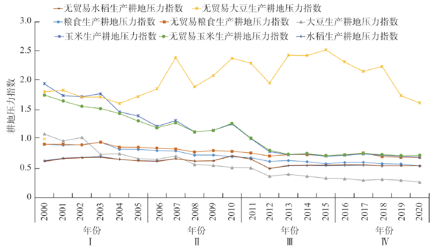
As an important agricultural production area, black soil region bears the important responsibility of ensuring national food security and maintaining agricultural ecological security. Protecting black soil is crucial to promoting sustainable agricultural development. This paper analyzes the changes of cultivated black soil pressure of grain production in Northeast China from 2000 to 2020, studies the impact of international trade on cultivated land pressure for grain production in the study area, and analyzes the competitive advantage of the agricultural products of the black soil region of Northeast China in domestic and international markets by using international market share index and trade competitive advantage index. Results show that in the past 20 years, the cultivated land pressure of grain production in the black soil region of Northeast China is basically at the safety level and presents a gradual downward trend. The cultivated land pressure of corn, soybean and rice decreased from 1.94, 1.09 and 0.63 in 2000 to 0.69, 0.26 and 0.54 in 2020, respectively. International grain trade plays a significant role in alleviating the pressure on cultivated soil for grain production and shows an increasing trend year by year. In 2020, the contribution rate to the mitigation of cultivated land pressure for grain production is 26.22%, of which the contribution rate to the mitigation of cultivated land pressure for soybean production is up to 511.48%. The results of the analysis of the agricultural product trade advantage degree show that agricultural products have obvious trade competitive advantages in the domestic market, but the competitive advantage in international trade is not obvious. Finally, this paper puts forward some suggestions on the protection of black soil under the background of changes in international grain trade, which provides a reference for the decision-making of black soil protection in Northeast China and the guarantee of grain production capacity.
Under the background that the black land degradation is becoming more and more serious, based on the survey data of 680 farmers in the black soil area of Jilin Province, the paper examines the impact of value perception and policy tools on farmers' black land conservation tillage behavior, and explores its mechanism and internal logic. The results show that: value perception has a significant impact on farmers' black land conservation tillage behavior, and the driving effect of policy making on their behavior is limited. However, through its regulatory role, policies can enhance the promotion of benefit perception on farmers' black land conservation tillage behavior, weaken the inhibitory effect of risk perception on farmers' black land conservation tillage behavior, and significantly increase the positive impact of value perception on decision-making of farmers' black land conservation tillage behavior. Therefore, in the process of enhancing farmers' black land conservation tillage behavior, giving full play to the internal incentive role of farmers' value perception, strengthening the external driving force of policy tools, and grasping the regulatory role of policy making on value perception is of great significance to promote farmers' participation in black land conservation tillage behavior.
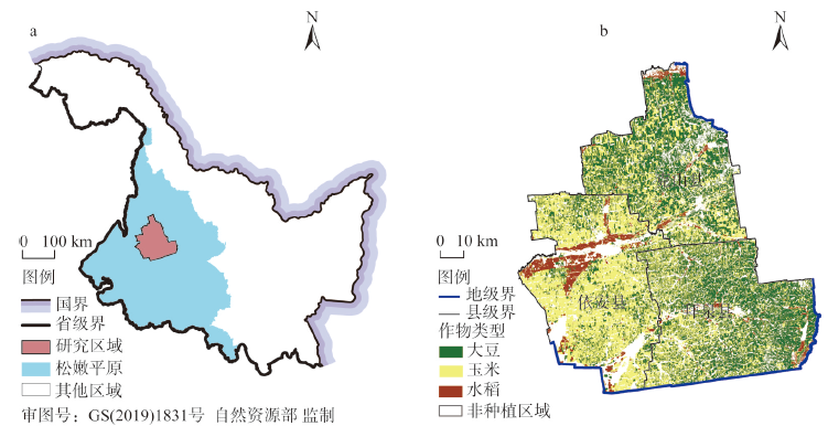
Rotation and fallow are important means to ensure the sustainable utilization of cultivated land resources in black soil regions. Determining the scale and spatial distribution of cultivated land for crop rotation and fallow scientifically is of great significance for undertaking land reclamation, improving soil fertility, and balancing the structure of food supply and demand in the black soil regions. Taking the typical black soil regions in Northeast China: Keshan county, Baiquan county, and Yi'an county as the research area, this paper reconstructs the farmland rotation and fallow layout at the plot scale by using the crop planting suitability evaluation model, multi-objective optimization (MOP) model, and agent-based land layout optimization allocation (AgentLA) model. Findings show that: (1) There are obvious spatial differences between high-value and low-value areas of the planting suitability of main crops. The high-value areas of corn and soybean planting suitability intersect in the north of Yi'an and the west of Keshan, which are the dominant areas of corn-soybean rotation. And the low-value areas converge in the south of Yi'an and the southwest of Baiquan, which are the key areas for fallow farming. (2) The crop rotation scale based on the optimization of the planting structure has achieved an increase in the proportion of soybean planting and a decrease in corn planting, alleviating the contradiction between the current phased oversupply of corn and insufficient supply of soybeans. Determining the scale of fallow by setting a variety of food supply and demand scenarios is conducive to flexibly responding to changes in the food market. (3) A rotation and fallow layout that takes into account the planting suitability and agglomeration of cultivated land is conducive to making full use of the comparative advantages of cultivated land resource endowments, developing large-scale operations, and playing an important role in improving the efficiency of cultivated land use. This research has helped to realize the simultaneous improvement of the spatial suitability, spatial agglomeration, rationality of planting structure, and the stability of food supply and demand of cultivated land, by rationally reconstructing the farmland rotation and fallow space in the black soil region, which provides policy reference for realizing sustainable utilization of cultivated land resources and food security in black soil regions.
From the perspective of supply and demand of water resources for cultivated land use, this paper comprehensively considered cultivated land use type, crop planting structure, crop growing period and other conditions, combined with the data from the national meteorological stations in Heilongjiang province, and explored the water demand for cultivated land use and effective water supply on the micro scale. Based on this, the spatio-temporal dynamics of land and water resources matching in different growing periods from 1990 to 2018 were analyzed. The results show that: the cultivated land structure of Heilongjiang had been changing from 1990 to 2018, and the phenomenon of changing from dryland to paddy was the most common from 2010 to 2018; the demand for water was greater in the early and middle stages of crop growth compared with the later stage. The water demand increases year by year, which is consistent with the change of paddy proportion, and the migration law of areas with high water demand is highly consistent with the phenomenon of dryland converting to paddy in the same period. From 1990 to 2018, the matching degree of land and water resources in each growth period of crops decreased first and then increased. Most high-value areas of land and water resources matching are distributed in the interface between high-value areas of effective precipitation and dryland areas. It can be seen that natural precipitation is still the main source of water for cultivated crops. In recent years, the matching degree of land and water resources in the southern part of the Sanjiang Plain decreased obviously, and the unit yield of grain declined. It is suggested to reduce the quantities of dryland-to-paddy conversion projects in this area. At the same time, the matching level of land and water resources and the unit yield of grain in the western part of the Songnen Plain increased year by year, so the dryland-to-paddy conversion project can be carried out appropriately.
Ground substrate, which can nurture the basic materials that support various natural resources, is the basic material formed by the natural action. Different types of ground substrates, such as rock, gravel, sand, soil, and mud, form the surface substratum layer through the organic combination of water, gas and biomass by natural action, and nurture and support each other with the surface cover layer, which maintains the normal operation of the earth's surface ecosystem and provides production, ecological and living services for human beings. As a type of invaluable natural resources, the black soil in Northeast China is a special ground substrate layer that supports and nurtures large areas of arable soil and forest soil, and serves a production and ecological service function that cannot be ignored. More and more attention has been paid to the rational utilization and development of black soil resources at home and abroad. Through the pilot survey of black soil ground substrate in Baoqing, the content, index elements and technical requirements for the survey were constructed, and the "four-in-one" survey and evaluation of black soil ground substrate quantity, quality, structure and function were carried out. On the basis of the understanding of the current situation of black soil resources in Baoqing, we proposed some suggestions on the evaluation of the rationality and development suitability of black soil resources. The comprehensive survey and evaluation of the suitability of black soil resources based on the ground substrate is of great and far-reaching significance to the scientific and rational protection and use of black soil resources.
The ecological degradation of cultivated land poses a serious threat to the sustainable development of black soil regions. Clarifying the law of the spatial and temporal differentiation is an important scientific proposition to improve the productivity of black soil cultivated land and achieve sustainable agricultural development. Taking Fujin, a typical city of black soil in Northeast China as the research area, based on the environmental stress and ecological restoration caused by external disturbance changes in cultivated land, the remote sensing-driven multi-source environmental stress monitoring model, the improved CRITIC model, and the optimized InVEST model are used to clarify the results of the interaction between the environmental stress and ecological restoration, revealing the spatio-temporal differentiation of the ecological degradation of cultivated land in the study area from 2000 to 2020. Results showed that: (1) The exogenous environmental stress intensity of cultivated land is overall low, showing a spatial and temporal differentiation pattern with the intensity being high in the east, west, and north, while low in the middle and south. (2) The endogenous ecological restoration intensity of the cultivated land is higher than the stress intensity, showing a spatial and temporal differentiation pattern with a west-east-central gradient attenuation. (3) A total of 968.12 km2 of cultivated land has experienced ecological degradation, which is concentrated in the eastern and central parts of the study area and sporadically distributed in other parts. The study clarified the interaction effect between multi-source environmental stress and multi-source ecological restoration, realized the dynamic sensitivity measurement of each cultivated land plot to various environmental stresses and ecological resilience, and further characterized the ecological degradation process and the measurement results, which is consistent with the actual cultivated land use intensity. The results provide theoretical reference and technical support for the accurate diagnosis of ecologically degraded cultivated land in black soil regions.
The mollisol region is one of the main grain-producing bases in China, especially the long gentle slopes. Unfortunately, more than 80% of farmland there was suffering from soil erosion, but the variation of soil erosion along the long gentle slopes was still unclear, which will make it more difficult to control soil erosion and protect soil resources. Therefore, the aim of this study was to find the variation law of soil erosion along the gentle slopes. Three gentle slopes (a straight slope, a concave slope and a compound slope ) in Keshan Farm No. 5 were selected as the objects. Soil samples were collected at 30 m intervals along the slopes in early May, 2019. Then the 137Cs-activity was measured to evaluate the soil erosion and deposition rates, and to measure soil organic carbon as a parameter of cultivated land soil quality. Wavelet analysis was employed to quantify the variation of soil erosion along the gentle slopes and the response of cultivated land soil quality parameters. The results showed that: (1) The annual average erosion rates of straight slope, composite slope and concave slope are 3040 t·km-2·a-1, 3395 t·km-2·a-1 and 4220 t·km-2·a-1, respecctively. (2) The main changing periods of the whole straight gentle slope, the concave gentle slope, and the compound gentle slope were 380 m, 250 m, and 300 m, respectively. (3) There was a significant negative correlation between soil SOC content and soil erosion rate, and the spatial distribution of soil SOC along the slope length was opposite to that of soil erosion rate, indicating that soil erosion is a key driving factor for soil degradation. Conclusions of this study can help to formulate the targeted soil and water conservation measures for the realization of soil nutrient management along long gentle slope and provides theoretical guidance for soil erosion control of the long gentle cultivated slopes in the mollisol region of Northeast China.
Soil denitrification is one of the important processes of soil nitrogen cycling, which is closely related to soil nitrogen loss and greenhouse gas emissions. The relation between communities and the release of N2O was analyzed in this study. The results showed that regardless the fertilization treatments, nirK type denitrifying bacteria had higher diversity than nirS type denitrifying bacteria, which were more susceptible to soil physical and chemical properties. Application of chemical fertilizer decreased soil nutrient content, the diversity of denitrifying bacteria and the release of N2O, while organic fertilizer (F+M and F+2M) application significantly increased the soil denitrification. Therefore, application of chemical fertilizer is not conducive to maintaining the fertility of black soil. Although the combined application of chemical fertilizer and organic fertilizer can improve soil fertility, the potential negative environmental effects can not be ignored. So, we suggested that the protection of black soil should actively promote the planting and breeding integrated mode, construct the recyclable agricultural system; appropriately apply organic fertilizers, regulate the activities of soil microbials; improve the relevant institutions, create new norms of scientific managements, and finally construct the multi-directional patterns for the protection of farmland in black soil region of Northeast China.
The effects of soybean continuous cropping (CS), maize continuous cropping (CM), corn-soybean rotation (MS), corn-corn-soybean (MMS) and corn-soy-soybean (MSS) on soil nitrogen fixing bacteria abundance and community structure were analyzed by fluorescence quantitative PCR and high-throughput sequencing. The results showed that soil organic matter (SOM), total phosphorus (TP), available nitrogen (AN) and available phosphorus (AP) contents in rotation were significantly higher than those in continuous cropping. The abundance of nitrogen-fixing bacteria in rotation was significantly higher than that in CM and significantly lower than that in CS. The diversity of NITR Ogen-fixing bacteria in MMS and MSS was significantly higher than that in CM. Total nitrogen (TN) was the main driving factor for the change of nitrogen-fixing bacteria community structure. Planting system indirectly affected the abundance and diversity of nitrogen-fixing bacteria through soil chemical properties. These results indicate that MSS and MMS are more conducive to the propagation of soil nitrogen-fixing bacteria in the semi-arid area of Western Jilin province, which can provide scientific basis for rational planting and nitrogen regulation from the perspective of microbiology.
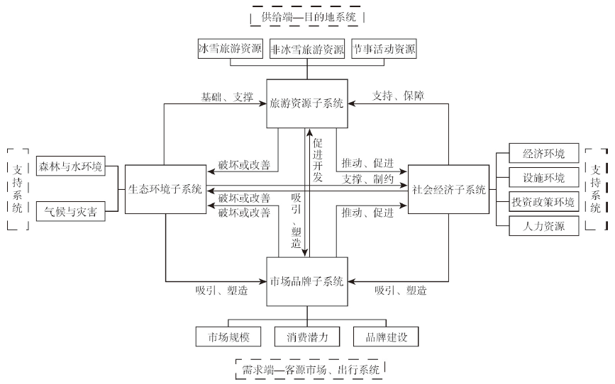
To promote the high-quality development of ice and snow resources is a new path and a new model to implement the sustainable development goals given by the United Nations, an important part to put the "Two Mountains Theory" into practice, and an important means to implement the strategy of national fitness for all and help build a sports power. As for the theoretical guidance of actual construction, the happiness theory clearly defines the ultimate goal of high-quality development of ice and snow resources. The value theory of resource economics provides a scientific tool for understanding the value and price accounting of ice and snow resources. The theory of human-land relationship in geography is the theoretical cornerstone for exploring the spatial differentiation law and the coupling path of human-land system. According to a series of changes and practical challenges of China's ice and snow resources development practice, this paper puts forward the approaches to high-quality development of China's ice and snow resources, that is, the adherence to the development mode of conceptual innovation, multiple coordinated development requirements, the concept of active development and the development goal of win-win between the subject and the object.
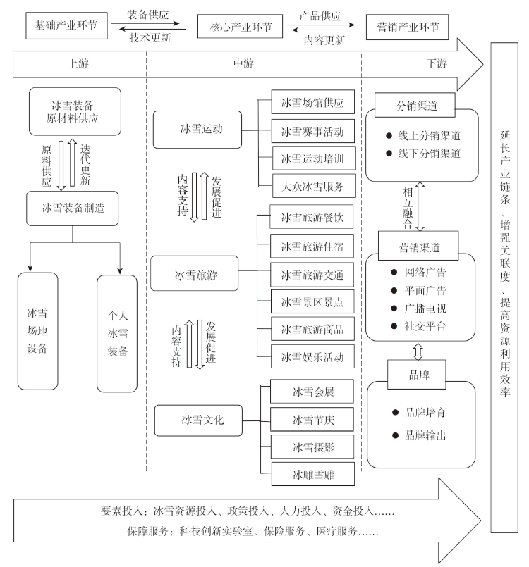
Preparations for the Beijing 2022 Winter Olympics have brought great opportunities for the development of ice and snow tourism in China and promoted the vigorous development of ice and snow tourism destinations. Based on the ice and snow tourism destination system theory, an evaluation index system for the development level of snow and ice tourism destinations was established, and the development level of four typical snow and ice tourism destinations in China, namely Chongli, Yabuli, Shennongjia and Xiling Snow Mountain was measured by using analytic hierarchy process (AHP), entropy weight method and weighted Topsis method. The results show that the development level of ice and snow tourism in Chongli is the highest, followed by Yabuli, while Shennongjia and Xiling Snow Mountain still need to be improved. Based on this, four typical development modes of ice and snow tourism destinations were extracted, including internal resource-driven mode, external market-driven mode, resource-market double-driven mode, and resource-market-policy comprehensive-driven mode. Finally, from the perspective of ice and snow tourism destination system, the optimal development path of China's ice and snow tourism destinations was put forward. The research is helpful to enrich the theories related to ice and snow tourism development and provide intellectual support and case reference for the high-quality development of ice and snow tourism destinations in China.
Based on the Baidu index data, the spatio-temporal evolution characteristics and influencing factors of the 26 representative ski resorts in the Chinese mainland were analyzed by using index measurement, spatial geographical analysis, regression model and geographic detector in 2011-2019. The results show that: (1) In terms of temporal evolution, the network attention first increased and then decreased, and gradually stabilized. 2015 and 2016 are the peak years, with obvious seasonal differences. There are two fluctuation peaks, and the distribution pattern is "single peak in the north and south, and double peaks in the middle and east". (2) In terms of spatial characteristics, the national and regional characteristics were first increasing and then decreasing, and the regional differences were significant. The degree of variation first decreased and then increased, and tended to be stable. The national distribution was relatively stable and balanced, and the regional distribution showed the characteristics of unstable agglomeration. The overall distribution of cold and hot spots at the provincial level showed a pattern of "hot in the northeast, but cold in the southwest", and the hierarchical change was mainly stable. (3) As for ski resort, the overall preference level changed greatly, the high preference remained stable and leading, and the other levels mainly changed downward. The classification of cold and hot spots in ski resorts showed a pattern of "hot in the north and cold in the south", and the evolution of the two hot spots in Northeast and North China was relatively stable. (4) In terms of influencing factors, the order of demand side is ski consumption attraction > education background > economic development level > informatization level > ski resort construction level. The proportion of ski trips, ski economic contribution, passenger carrying capacity, abundance of ice and snow tourism resources and the construction level of official media on the supply side have strong explanatory power, and the influence of other factors is not significant.
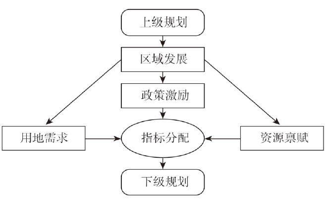
Top-down allocation of land quota is a key tool in China's implementation of spatial planning and regulation of territorial space. Based on land quota data of provincial land use plan (2006-2020), this study used a hierarchical linear model to analyze the strategy, preference, and influencing factors of incremental construction land quota allocated by provincial governments to prefecture-level administrative units and discussed the interaction of provincial and prefecture-level factors. The results showed that the allocation strategy and preference of land quota in provincial land use plan had obvious regional differences. The absolute amount of land quotas was high in the east and low in the west, but the relative amount of land quotas was high in the west and southeast, while low in the central and northeast parts. The existing quota distribution mode adopted by provincial governments was found to be driven primarily by the demand for economic development, which did not pay sufficient attention to the constraints of the carrying capacity of land, water, and other types of resources. Additionally, provinces undergoing a rapid growth tend to adopt a centralized allocation strategy, while those at high development levels often have a more balanced scheme of land allocation. Therefore, it is necessary to adhere to the bottom line of resources and environment, cooperate with effective economic incentive policies, and implement regionally differentiated strategies in land quota allocation and land management.
Ecological restoration of territorial space is essentially important to the sustainability of ecosystem services, and spatial zoning plays a significant role in the procedure of ecological restoration. In order to address the problems of simplified zoning level and poor applicability of zoning results, a zoning framework for ecological restoration, "natural site conditions-dominant ecological functions-ecological stress issues" was proposed in this paper. Then a case study was carried out in Maotiao River Basin, a typical karst region in Guizhou. For the first-level zone of ecological restoration, natural condition indicators were selected, such as altitude, slope, topographic relief and vegetation type, to analyze the regional differentiation. Based on ecosystem service functions including water conservation, soil conservation, food supply, and biodiversity maintenance, the dominant ecological functions were identified and the second-level zone of ecological restoration were completed. For the third-level zone of ecological restoration, key ecological stress indicators such as rocky desertification sensitivity, soil erosion sensitivity, and ecological degradation were integrated. Following that, the territorial space of Maotiao River Basin was divided into 3 first-level ecological restoration zones, 10 second-level zones, and 30 third-level zones, and corresponding ecological restoration strategies are proposed. This study can be a scientific support for the ecological restoration of the Maotiao River Basin, and also a helpful reference for the ecological restoration zoning for the southwest karst area in China.
Under the background of the unified investigation, monitoring and evaluation of natural resources, it is of great significance to develop an evaluation model for the comprehensive utilization of natural resources, which helps to introduce long-term mechanisms for the management and protection of natural resources. Based on the theory of sustainable development, this research constructed a comprehensive evaluation index system of natural resources utilization benefit, consisting of 3 primary indicators and 23 secondary indexes. Then, the extremum method was used for index standardization, and analytic hierarchy process (AHP) and entropy value method were used for weight. The evaluation results of natural resources utilization benefits of China's 31 provincial-level regions in 2018 were analyzed, and the limiting factors of natural resource utilization benefit were identified by using the obstacle degree model. The results show that: (1) The economic benefits of natural resources in China differ greatly and the overall trend is decreasing from southeast to central, northeast and northwest. The level of social benefits is close and there is no obvious spatial differentiation. The ecological benefits were higher in the south than those in the north. There is a great difference in the level of comprehensive utilization of natural resources, and the spatial distribution pattern depicts a decreasing trend from east to west. (2) The limiting factors of natural resource utilization benefits are different in different regions. GDP per unit construction land of economic benefit, green coverage rate in built-up area of social benefit and comprehensive control ratio of soil and water loss of ecological benefit are the main limiting factors. According to the level of individual benefits and limiting factors, every province can formulate targeted measures and policies to improve the benefits of comprehensive utilization of natural resources. (3) The results of natural resources comprehensive utilization benefit are consistent with the actual situation of the provinces in general, which indicates that the evaluation index system of natural resources utilization benefits from the perspective of sustainable utilization is scientific and feasible. However, due to the limitations of data availability, the indexes need further improvement, such as indicators of social benefits related to human well-being and indicators of ecological benefit in relation with carbon sequestration and ecosystem services. The research results can enrich the theoretical system and the technical methods of evaluation of the natural resources utilization benefits, and serve to improve the utilization efficiency of natural resources and realize rational development of regional resources.
Taking electric power as the research object, this paper selects the matching data of China Family Panel Studies (CFPS) and energy price distortion index from 2014 to 2018 to explore the impact of residential energy price distortion on household consumption and its mechanism from the micro household level. The results show that: (1) There are generally negative distortions in residential electricity prices, which is conducive to promoting the improvement of household consumption level, especially the consumption of household electricity, food, clothing, equipment and daily necessities, transportation and communication, cultural and entertainment and others. (2) Residential energy price distortion affects household consumption level and consumption structure through income effect and complementary effect. (3) The impact of energy price distortion on household consumption is heterogeneous between urban and rural families and between families with different incomes. Residential energy price distortion has a greater effect on rural households' consumption than on urban households', and the promotion effect of residential energy price distortion on urban and rural household consumption is reflected in increasing the household consumption of their high-income groups. These conclusions provide decision-making reference for advancing energy market-oriented reform and establishing a fair and efficient energy price mechanism.
The focus of China's anti-poverty campaign has shifted from getting rid of absolute poverty to comprehensively implementing rural revitalization and systematically addressing relative poverty. The reform of separation of three rights (TRSP) is an important part of the rural land system reform and the key to the implementation of the rural revitalization strategy and common prosperity. Based on the data of 1038 rural households in the Middle and Lower Reaches of the Yangtze River, this paper uses Structural Equation model to explore the impact of the TRSP on multi-operators' income. The results show that: (1) For agricultural operators, overall, the TRSP has a positive impact on family farms and capital farms, but it has a negative impact on the traditional farmers and skilled farmers. The main reason for income loss of traditional farmers and skilled farmers is the shrinkage of operation scale and negative direct effect, respectively, while the income increase of family farms and capital farms depends on the path of scale expansion. (2) For off-farm farmers, the TRSP has a positive impact on the income of commercial farmers and agricultural employees. The TRSP does not directly affect the income of the off-farm farmers, and it mainly improves the income of the commercial farmers and agricultural employees through the two indirect paths of labor transfer and the relaxation of the liquidity constraint. (3) The total effect of the TRSP on the income of the off-farm farmers is higher than that of traditional farmers and skilled farmers, but lower than that of family farms and capital farms. The income gap between the agricultural operators is much higher than that between the off-farm farmers. The research findings of this paper are helpful to understand and grasp the performance of the ongoing reform and have guiding significance for improving relevant systems and policies, facilitating the smooth implementation of policies, and guaranteeing the welfare of farmers.
In the context of rural revitalization, based on the data of 1597 3A-level scenic villages in Zhejiang Province, this paper uses the nearest distance index and point density analysis, combined with data processing and analysis tools such as ArcGIS 10.6 and geographical detectors, to explore the spatial structure characteristics and influencing factors of 3A-level scenic spots (villages) in the province and its prefecture-level cities, and propose ideas for the spatial structure optimization as follows: (1) The spatial distribution of 3A-level scenic spots (villages) in the study area is featured by a remarkable aggregation, and the spatial structure presents a Chinese "万"-shaped structure. (2) The prefecture-level cities are significantly different in the spatial pattern, tending to be distributed in places with low altitudes, plains, sunny slopes, rivers, trunk lines and central areas. (3) The number of the 3A-level scenic spots (villages) is negatively correlated with the elevation, slope, slope variation rate and slope aspect variation rate, and the villages are significantly aggregated and radiated within a range of 5 km from the water body, 40 km from a prefecture-level city, 15 km from a district or a county, 4 km from the main road and 20 km from a high-level scenic spot with the remarkable aggregation and radiation. (4) The natural factors are predetermined among the influencing factors of spatial structure characteristics in 3A-level scenic spots (villages), while the human factors are the driving forces of village transformation. (5) The optimization of villages in 3A-level scenic spots can facilitate the multi-core radiation structure and the core aggregation-diffusion structure by further promoting the area with points, adjust the aggregation-confluence structure with the line as the axis, and harmonize the structure of the relationship between similarities and differences by magnifying the unique points in the same area.