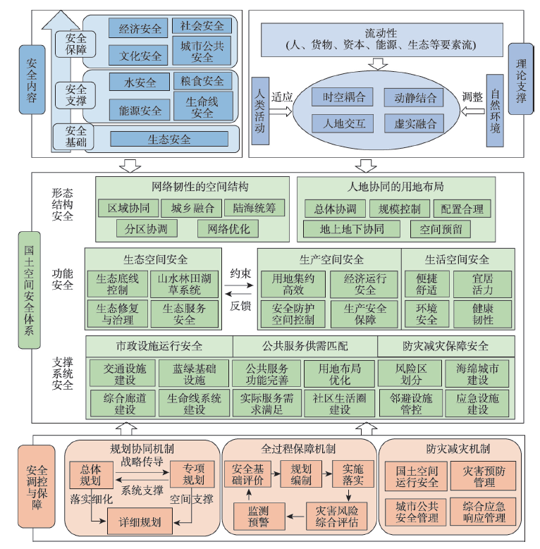
Security is an important aspect for sustainable development of territorial space. It is also a crucial issue in planning, implementing, and supervision of territorial space. With the rapid development of urbanization and industrialization, people, goods, energy, resources and other factors flow more frequently in different regions, between urban and rural areas, and within urban spaces. The coupling relationships between human activities and natural resources have become more and more unstable, which exacerbates the risk of human survival. It is urgent to establish the territory spatial security framework faced with the uncertainty of human activity and elemental flows. This paper explores the security of territorial space from the perspective of mobility. On the basis of the safety of activities in different spaces and the safety of resources and ecology, we should consider the coupling of elemental flows, human activities, and resources and environment, as well as potential risks. The relationships between mobility and territory spatial security can be characterized from three aspects: the coupling of space of flows and space of places, the coordination among resource supply-flow-demand and the reconfiguration of resource, and elemental flows and the resilience of the territory spatial system. Towards safety goals of ecology, water, food, economy, society, and other elements, it is crucial to explore the uncertain impacts of various elemental flows on the man-land system and the mobility risks under extreme conditions such as natural disasters and sudden public safety incidents. It is also important to lead the self-adaptation and benign feedback adjustment between human activities and natural environmental systems through optimizing resource allocation and territory spatial layout. Thus, we proposed a framework of territory spatial security. In territory spatial planning, it is necessary to carry out the coupling coordination analysis with elemental flows and territorial spatial development and protection, to establish new analysis methods of territory spatial structure combining spatial forms and flows, and to enhance the functional flexibility of different spaces to adapt to the uncertainty of elemental flows and activity agglomeration, as well as to construct territory spatial supporting systems that synergize supply and demand. This study is of great significance for improving the sustainable development of territorial space and ensuring the safety of human survival.
Key ecological function counties with limited development undertake the dual mission of ecological protection and economic development. Accounting of gains and losses of ecological assets is an effective way to quantify the paid use of regional resources, ecosystem protection and restoration and ecological performance appraisals. Taking Shengzhou city of Zhejiang province as a typical county-level unit of important ecological barrier function area, the spatiotemporal dynamic changes of ecological stock and flow assets in recent 20 years were evaluated based on a grid scale, and the driving factors of gains and losses of ecological assets were evaluated based on Geodetector and the monitoring of human activity types. The results showed that from 2000 to 2018, due to the reduction of quality and areas of forest ecological assets, the ecological stock assets in nearly 60% of Shengzhou city showed a decreasing trend, while the total value and the value per unit area of ecological flow assets gained by more than 10%. Compared with natural factors, socio-economic factors contributed more to the change of ecological assets in Shengzhou city, with a contribution rate of 17%. Urbanization led to a slight reduction in grain supply at the county level, and ecological assets in more than 70% of the township gained, especially Shihuang town, which showed a good result in ecological protection, with gains in the value per unit area of ecological flow assets of more than 20 million yuan/km2. Therefore, more attention should be paid to the protection of forest resources, strict design of basic farmland protection redlines, and reasonable land use planning in the process of urbanization in the future.
Guangdong-Hong Kong-Macao Greater Bay Area has abundant wetlands, but it is facing environmental stress caused by human activities. Based on Human Pressure Index (HPI) and spatial autocorrelation method, this paper explores the spatial relationship between the distribution of wetlands and human pressure in the Greater Bay Area, so as to identify wetlands of great significance. The results are as follows: (1) Wetlands in the Greater Bay Area are mostly distributed on the west bank of the Pearl River, while wetlands within cities are scarce. Human pressure varies between cities and within cities. Human pressure on the east bank of the Pearl River is higher than that of the west bank. The distribution of wetlands and human pressure is spatially correlated. (2) After screening and comparison of different ways of using spatial autocorrelation method, the spatial cluster types correspond to three types of wetlands: important wetlands, potentially important wetlands, and non-important wetlands. (3) Important wetlands, with high human pressure, which are mostly ponds and mainly distributed in urban built-up areas and surrounding areas, need to act the function of water security and ecological economic benefit in cities in order to achieve relative balance between protection and utilization of wetlands. Potentially important wetlands, with low human pressure, are mostly distributed at the Pearl River Estuary and the west bank of the Pearl River. With the progress of urbanization and the increase of human pressure, potentially important wetlands may become important wetlands. Non-important wetlands, fragmented in various places, tend to disappear in the future. This study lays a foundation for exploring the evolution of wetlands under the influence of human pressure and provides application reference for the protection and utilization of wetlands.
The transmission of territorial spatial planning should cover all process of planning, implementation and supervision. Based on the three "needs" of modernization of territorial spatial governance, the paper analyzed the inadaptability of traditional spatial planning conduction. Starting from the whole chain governance logic of full-scale, whole-process and multiple dimensions, the paper constructed a transmission system of "three-chain coordination" and three paths of "spatial chain", "time chain" and "feedback chain" matching the territorial spatial planning needs and system in the new era, which include a closed-loop system for territorial spatial governance that covers the whole process of planning, implementation and supervision, a full-scale spatial transmission chain with clear authority from top to bottom, a full-process time transmission chain from core to edge oriented to implementation and a multi-dimensional feedback transmission chain with multiple co-governance and dynamic maintenance, in order to provide theoretical and practical reference for the transmission of territorial spatial planning.
The spatial pattern of living, producing and ecological spaces has a profound impact on regional ecosystem services and the well-being of the residents in rapidly urbanizing watersheds. However, few studies considered the relationship between ecosystem services and multiple stakeholders' well-beings. In this study, we selected seven ecosystem service indicators to identify living, producing and ecological hotspots in a typical urbanizing area, Baiyangdian watershed. Then we conducted a participatory mapping to integrate multiple stakeholders' needs into the identification of their major functions. The results show that overlapped hotspots occupy 14.5% of the total area of the watershed, which is dominated by overlapped producing and ecological functions. Furthermore, the identification of the major functions varies among different stakeholders. On the one hand, urban residents are more likely to identify the overlapped areas to living space because they prefer cultural services than rural residents. They mention cultural services twice of that by rural residents in the survey. On the other hand, policy makers pay more attention to the ecological function of the upper streams, while poverty alleviation workers focus on the producing function of the forests in this area. This study illustrates a method to integrate multi-stakeholders' preferences in spatial optimization, which can be used in the planning of the living-producing-ecological spaces and the territorial space planning.
To figure out the number and pattern of the vacant houses is essential for spatial planning and city examination & evaluation. However, the limitation of fine data and methods has been a big barrier to accurately identifying and revealing the dynamic pattern of vacant houses. This paper developed a computational model to identify the vacant houses and to calculate the residential housing vacancy rate (HVR) based on the monthly electricity consumption data from all the households in X county in 2019. The results showed that: (1) The HVR of X county was 21.64%, and 33.81% of households had been vacant in 2019. Meanwhile, the rate of the households that were vacant in Chinese New Year's Eve and had been vacant all the year was 19.97% and 11.45%, respectively. (2) The monthly HVR fluctuated regularly, with February, August at the bottom, and May and November at the peak. However, the HVR of February when China's traditional Spring Festival fell did not decline as much as we expected. (3) The village HVR had spatial autocorrelation attribute and the urban built-up areas were the hotspots which deserve more attention. (4) Being vacant all the year is the top one model among 1931 vacant types. The paper held the view that the mechanism of the vacant in X county is (1) the change of the form of population migration and mobility; (2) housing filtering which occurred in rural families, and (3) over "housing urbanization" in the urban built-up areas. We argue that identifying and sensing vacant houses are fundamental works in spatial planning. Meanwhile, spatial planning should react properly to the rural vacant houses and transform the goal from the expansion of land to rising the wellbeing of people. We need to pay much attention to the vacant houses in the city because it is a signal of the mistake in planning. The vacant identifying computational model and the research result are helpful to advance housing vacancy study, which is significant for spatial planning.
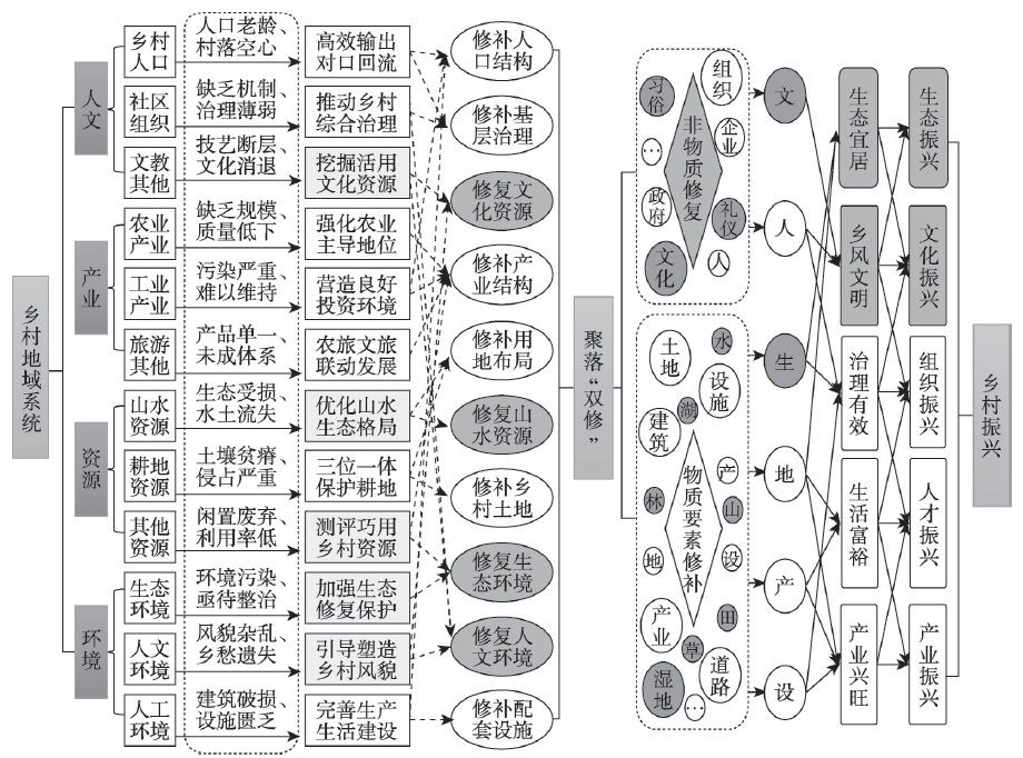
In the process of rapid development of urbanization, rural withering poses a severe challenge to urban-rural coordination and regional sustainable development. Seeking the path of rural development is an important measure to carry out the strategy of rural revitalization, and it is also an urgent core task. Focusing on the rural regional system, this paper clarifies the connotation of "double repair", namely, the material elements repair and the non-material elements repair of rural settlements. In view of the development problems faced by rural areas, through the integration of "Ecological" and "Historical and cultural" resources, the transfer and construction of "Population", "Land", "Industry" and "Supporting facilities", this paper probes into the scientific mode and revitalization path of eradicating "Rural disease": In contrast to the "double revision" standard, strengthening green development to rejuvenate rural ecology; the six-in-one and cultural prosperity to rejuvenate rural culture; the efficient export of population and the return of counterpart to rejuvenate rural talents; the horizontal combination and vertical advancement to rejuvenate rural industry; the "Tokuji, rule of law, autonomy" sandwich integration and multi-dimensional co-construction to rejuvenate rural organizations. Taking Shajing village in Qidong county as an example, this paper puts forward the repair strategies and measures from the six aspects of culture, ecology, people, land, production and infrastructure, so as to achieve the purpose of repairing rural ecological capital, cultivating rural cultural capital, restoring rural social vitality, revitalizing rural industrial economy and improving rural living environment.
Taking Shaanxi province as the case study area, this paper constructed an evaluation index system of rural transformation development with rural core elements such as population, land and industry to analyze the evolution of spatiotemporal pattern of rural transformation development. Then, the influencing factors and the spatial differentiation of their effects were discerned by Stepwise Regression model and Geographically Weighted Regression model, in order to provide a reference for policy formulation of high-quality development of rural areas in Shaanxi province. Our findings were as follows: (1) From 2005 to 2017, the degree of rural transformation development in Shaanxi showed a continuous upward trend. In the province, Xi'an and its surrounding areas as well as the energy area of northern Yulin city developed fast, and the rural transformation has experienced a process from being led by lower-level transformation to low-level and moderate-level transformation. (2) Fixed asset investment per unit land, weighted road network density, per capita GDP, number of industrial enterprises above designated size and per capita cultivated land resources were the main influencing factors of rural transformation. (3) Except for the per capita cultivated land resources which restricted rural development, other factors had positive effect in promoting rural transformation. Each influencing factor has different degrees of influence on different counties, and the spatial differentiation of influence effect is obvious. This research has important reference significance for Shaanxi province to formulate differentiated policies and measures for rural transformation and development in accordance with local conditions.
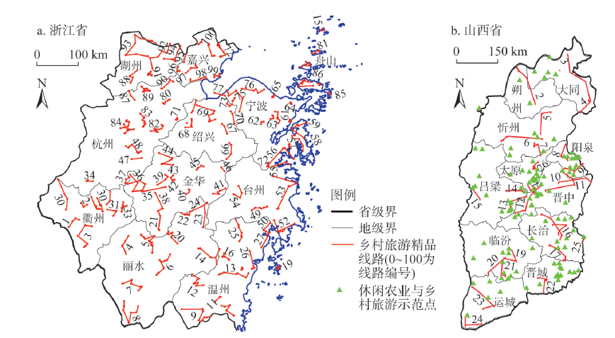
The regional differences of rural tourism development is the external characteristic of rural tourism investment (RTI) spatial imbalance. The paper compares and analyzes the spatial differences of rural tourism development systematically, taking Zhejiang province in the developed eastern region and Shanxi province in the underdeveloped region as the case study. And it deeply explores formation mechanism of regional differences in rural tourism development from the perspective of industrial investment, based on the regional different "natural-industrial-social" environments, to scientifically understand the process and mechanism of RTI influencing the industrial development. The results show that: (1) There are significant differences in development level and market maturity of rural tourism between Zhejiang and Shanxi, which are characterized by excellent rural tourism routes. The standard deviations of the excellent rural tourism routes are 3.30 and 7.15, respectively, reflecting that the development of industrial products has obvious advantages in Zhejiang, while Shanxi is still dominated by traditional rural tourism products. (2) There are also significant differences in the contribution level of "natural-industrial-social" environmental factors to RTI. The industrial basic environment is the most prominent to regional rural tourism development, the natural ecological environment is the basic foundation for regional rural tourism, and the social and cultural environment plays a positive role in promoting tourism development. (3) The spatial difference of rural tourism development is the result of the difference of regional RTI and its development environment. Affected by the difference of regional investment environment, the difference of rural tourism investment income and return expectation in different regions has been widened, and the choice of rural tourism development path and mode, forming the regional difference of rural tourism development. Finally, according to characteristics on the contribution of industrial investment environmental factors to the development of rural tourism, this paper puts forward the IE maps model of regional RTI, which can better promote development of regional rural tourism so as to implement the rural vitalization strategy.
Due to the dual disturbance of natural conditions and human activities, rural settlements systems in mountainous areas are experiencing a profound transformation. Exploring the spatial and temporal pattern characteristics of rural settlements in mountainous areas and their optimization strategies is conducive to promoting the comprehensive management of land space and rural revitalization in such regions. By employing landscape pattern index, grid weight overlay evaluation, improved ant colony algorithm, etc., this study, with Chengjiang town of Chongqing as an example, constructs a theoretical analysis framework to explore the spatio-temporal evolution characteristics of rural settlements under rapid urbanization, so as formulate the optimization and control strategy of rural settlements pattern in mountainous areas. The results show that: (1) The spatial pattern evolution of rural settlements in the study area showed a trend of concentrated and close evolution, and generally showed four distribution patterns of homogeneity, linearity, centripetal and courtyard, meanwhile, the elevation, slope, water area, town, infrastructure and other natural, economic and social factors have an significant impact on the spatial and temporal pattern evolution of rural settlements in mountainous areas. (2) The results of improved ant colony algorithm optimization shows that the patch area (CA) of rural settlements in the study area decreased by 10.07%. Meanwhile, the patch number (NP) and density (PD) decreased by 83.12% and 81.16%, respectively. The mean patch size (MPS), and the mean nearest neighbor distance (MENN) increased by 4.3 times and 42.82%, respectively. The results of optimization show that 69.1% of the rural residential patches are concentrated in suitable areas and relative suitable areas, and the concentration occurs close to convenient transportation, perfect public facilities, convenient production and central villages. The layout of rural settlements is more compact and orderly, and the land is more intensive and economical. (3) The optimization results also show that the improved ant colony algorithm is very suitable for the spatial layout optimization of town scale elements under complex environmental conditions, and can provide a scientific basis for the optimization of land use and living space pattern in the compilation of land spatial planning in mountainous areas.
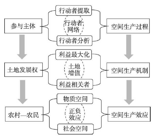
From the perspective of the production of space, this paper combined actor network theory and stakeholders to construct an analytical framework based on "process of the production of space-mechanism of the production of space-effect of the production of space" to analyze rural construction land consolidation (RCLC). Collecting first-hand data through in-depth interview method, this paper took Yaotang village in Guangdong province as the research area, and analyzed the process, mechanism and effect of RCLC. The results show that: (1) In the process of RCLC in Yaotang village, the town government as the key actor, the party-mass council as the core actors and other actors were actively recruited and mobilized to finish the process of the production of space. In order to meet their own interests, all actors constructed a network through the obligatory passage point of "collectively demolishing idle, dangerous and dilapidated houses, building a new village and developing industries". (2) Yaotang village's internal and external forces worked together to form the RCLC mechanism, specifically, land increment value as the internal driving force released the transaction value, management value and production value of land development rights, and the maximization of the interests of the core stakeholders as the external driving force. (3) Rationally configured land development rights were used by the village collective as a way to seek long-term development in rural areas, which makes use of the external and endogenous driving forces of rural development to guide urban and rural elements to form a "secondary flow", and brings positive effects to the production of rural material space. But in this process, some farmers' residing rights were ignored, resulting in spatial isolation within the countryside, and causing negative effects on the production of rural social space.
The sustainable development of tourism depends on the input of various environmental resources as well as the scientific and effective governance. However, the governance of common-pool resources in tourism destinations still needs to be deepened. As a kind of typical common-pool resources, water is the key to sustainable tourism. Taking the core area of Hani Terraces as a case of study, based on the conceptual framework of water-rights hierarchy and using qualitative research methods such as in-depth interview and participatory observation, this paper explored the evolution of water-rights hierarchy in Hani Terraces before and after the development of mass tourism. The results show that: (1) The change of political regime and the development of mass tourism are the main driving forces for the evolution of water-rights hierarchy in Hani Terraces, which affect the residents' water utilization practice from the aspects of empowerment system and distribution mode. (2) Under the context of tourism, the heterogeneity of the users in Hani Terraces was enhanced to a large extent and the scarcity of water resources was also improved, thus water resources are undergoing a process of commercialization. (3) Under the hierarchical structure, the decision-making entity at the collective level, as the middle layer connecting the decision-making entity at the national level and the user level, can promote the fair use and sustainable development of resources only by giving full play to its supervisory and management governance function. At this stage, the governance of water resources in Hani Terraces is dominated by the water trading market, and the lack of governance from local authorities has worsened the situation, and Hani Terraces is facing the challenge of sustainable development.
As a key carrier of social-ecological systems, the green space in the old urban communities is a critical issue for urban high-quality development and transformation governance demands. This study constructs the basic units of green space service in old urban areas of Guangzhou. We introduce the three-dimensional framework of potential-connectedness-resilience of adaptive cycle theory to construct a green space landscape index system representing ecological, social, and economic services. This index system evaluates the spatial resilience level and adaptability transformation characteristics of green space in old urban areas of Guangzhou from 2000 to 2018. Results show that the spatial resilience evolution of the old urban green space has apparent spatiotemporal differentiation in the core and peripheral areas. In demolition reconstruction phase we witness the fast development-quick release-restructuring; in micro renewal stage mainly emerges the development-protection, which consists of three types of improvement, stability, and alternation in social-ecological system services adaptability. The results indicate that urban renewal can regulate the governance of social-ecological services. Among them, green space shape index, green space rate within a 5-minute range, and land use mix degree have significantly promote the resilience of core green space, which provides successful examples for the governance in the peripheral areas. Meanwhile, this paper discusses the relationship between renewal policy and the spatial resilience evolution of green space, which provides a theoretical and empirical study of social-ecological system adaptability for promoting green space renewal governance in old urban areas.
Improving the overall level of forest ecological security is an inevitable choice for the ecological civilization construction and the sustainable development of forestry. Based on the quantitative measurement of forest ecological security in 31 provinces (municipalities and autonomous regions) of China from 2009 to 2018, the modified gravity model was used to calculate the correlation of the forest ecological security between provinces. Based on this, the spatial correlation network of forest ecological security was constructed, and its characteristics and driving mechanism were examined by the social network analysis. The results showed that: (1) The spatial correlation network of forest ecological security in China had good accessibility and significant hierarchy, but the correlation strength and stability were low. (2) The spatial correlation network of forest ecological security presented an obvious "center-edge" feature, with provinces such as Shandong, Henan, Hubei and Hunan at the center of the network and playing an important intermediary role. (3) The spatial correlation network of China's forest ecological security can be divided into four blocks: brokers block (ten provinces including Henan and Shandong), net spillovers block (four provinces including Jilin and Heilongjiang), net benefits block (eight provinces including Jiangsu and Anhui), and two-way spillover block (nine provinces including Guangxi and Sichuan). At the same time, a spatial correlation feature, namely, the aggregation within the block, is dominant and the correlation between blocks is complementary. (4) Differences in economic development, forestry structure, urbanization, forestry ecological investment and forest resource had negative driving force on forest ecological security spatial correlation network in China, while the geographical adjacency relationship had positive driving effect.
As an important part of national land space, ecological space is the basis of human production and life. Taking Hulun Buir city of Inner Mongolia Autonomous Region as an example, this paper systematically constructs an evaluation index system of comprehensive ecological space importance, and then carries out the quantitative identification of ecological space. On this basis, the dynamic evolution characteristics of ecological space are analyzed to find the spatiotemporal differentiation law of ecological space in the study area. The research found that: (1) The overall importance index of ecological space is high. During the study period, the proportion of core type and importance type of ecological space in the total area maintained at above 50%, and showed a gradual upward trend. The core type, importance type and non-critical type of ecological space showed an increasing trend, while transitional type and general type showed a decreasing trend. (2) The comprehensive activity degree of ecological space showed a gradual increase, with the highest value in 2015-2018, accounting for 7.85%. (3) The stability of core type, importance type and non-critical type of ecological spaces was much better during the study period, compared with that of transitional type and general type. In addition, as the overall importance index of ecological space showed an upward trend, and all types of ecological space were mainly converted to the type of ecological space with higher importance index. (4) The change of ecological importance has obvious spatial heterogeneity. During the study period, the ecological space with continuous higher level of importance is mainly distributed in forest region of Da Hinggan Mountains and the core water bodies such as Hulun Lake, while the ecological space with continuous lower level of importance is mainly distributed in pastoral areas in the west and farming areas in the east. On the whole, the ecological environment of Hulun Buir grassland was improved obviously during the study period.
Taking 21 APEC countries (regions) as the research object, this paper constructs the APEC tourism flow network from 2008 to 2018, and analyzes the evolution and influencing factors of the tourism flow network structure in SNA and QAP methods. The results show that: (1) The density of APEC tourism flow network continues to increase, but still at a relatively low level, and the network structure is not stable. The trend of network centralization has weakened, and the supply market is more diversified. (2) There are obvious differences in the centrality level among nodes of APEC tourism flow network, forming the first echelon led by China and the United States, the second echelon represented by Japan and South Korea, and the third echelon represented by New Zealand and Russia. (3) The core-edge structure of the APEC tourism flow network is significant and stable. The tourism interaction between the nodes in the core area is the most frequent, and the feedback effect of the edge area on the core area is obvious. (4) The location has always been the key factor affecting the tourism flow network structure. The influence of economic development level, tourism resource endowment and tourism infrastructure on the tourism flow network structure has decreased, while the influence of the degree of opening to the outside world on the tourism flow network structure has increased.
The application of water-saving technology is an important measure to save agricultural water resources. However, agricultural irrigation water consumption in many areas has not decreased with the application of such technology. By applying the panel data of 52 cities at prefecture level or above in China's main grain producing areas from 2000 to 2018, and using Malmquist index and LMDI index, we calculated the rebound amount of agricultural irrigation water brought by water-saving technology and the expected agricultural water-saving consumption. The results of the study show that the average rebound effect of irrigation water consumption in the North China Plain was 15.02% during the study period, which means that the North China Plain has not fully achieved the expected result brought by the application of water-saving technology. The application of technology relaxes the constraints of water resources. Farmers will expand the irrigated area or increase planting of high-water-consumption and high-yield crops. The effect of water-saving technology is weakened. There are different rebound degrees of irrigation water consumption in the Yellow River, Huaihe River and Haihe River basins. The average value of the overall rebound effect in the Yellow River is 41.39%, and the degree of the rebound effect is the greatest, while the overall rebound effect in the Huaihe River is the least. From the perspective of administrative region, the rebound effect of agricultural irrigation water was mainly found in Shandong, Henan and Hebei provinces. The overall average value of the rebound effect in Henan Province is 49.89%, followed by Shandong Province (29.98%), and Hebei Province (23.89%). The increase in water-saving irrigation area is the direct cause for the rebound effect of agricultural water-saving. The increase in investment in farmland irrigation water conservancy construction and the imperfect construction of water rights market are the root causes. The regional heterogeneity of rebound effect is caused by the differences in the application level of water-saving technology and the construction of water rights trading system. However, this heterogeneity will be gradually eliminated with the increase of investment in farmland irrigation conservancy construction and the improvement of water rights trading system. The research conclusion is of great significance for the adjustment of water-saving technology and irrigation policy in the North China Plain.
Rain flood adaptability is a significant evaluation criterion in design of a sponge city, which reflects the bottom line constraints and the priority principle of ecological space in the construction of a sponge city. INVEST model and GIS were used to evaluate the rain flood adaptability, and classify the function of rain flood adaptability and safety level of rain flood adaptability. The research in this paper shows that: (1) The evaluation of rain flood adaptability on the respect of water source conservation, soil conservation and water purification, mixture of rain flood routes and adaptation levels and function division of rain flood adaptability, reflected the inter source corridor and basic framework of rain flood adaptation system. (2) The safety pattern of rain flood is the spatial form of sponge facilities. We reconstructed different safety levels of rain flood adaptability space, which achieved the balance of "source sink" and formed an urban rain and flood safety system. (3) Rain flood adaptability can control the rain flood by unity and coordination from micro to macro level through coupling of hydrologic process and spatial pattern. It is also of important significance to the learning and transformation of rain flood in the sponge city and to the development of the self-organizing ability to deal with shocks of a city’s uncertainty.