The integrated high-quality development of the Yangtze River Delta (YRD) is of great importance for the long-term development and stability of China's economy. In order to scientifically and comprehensively understand the problems existing in the development of the YRD in the New Era and clarify the future development path, experts from different fields are invited to discuss the regional coordination, industrial coordination, and transportation organization. Interviews were conducted on research frontiers such as urban system evolution, cross-regional cooperation, factor allocation, river basin planning, integration paths, and green and low-carbon development. The interview results show that the YRD is the region with the most active economic development, the highest degree of openness and the strongest innovation ability in China. But it is still characterized by prominent problems, such as unbalanced internal development, fragmented inter-regional traffic, remaining administrative barriers, unsound river basin ecological cooperation, insufficient coordinated industrial development and weak green economic system. The strategic position of the study area in the development of China and the world requires the integration of theoretical knowledge of various disciplines and subjects, and continuous attention to the major scientific proposition of the integrated high-quality development of the delta region from different perspectives. Closely related to "integration" and "high quality", the integration of the YRD should first innovate the mechanism to narrow the development differences within the region, strengthen the basic support for comprehensive transportation integration, and break through the constraints of administrative boundaries. Secondly, to innovate the mechanism and system to ensure the effective flow and allocation of production factors, through the integration and development of the value chain, industrial chain, and innovation chain to consolidate the integration; again, to promote the centralized use of land elements in the YRD, improve the land carrying capacity of the YRD, and integrate the whole delta region. High-quality development provides sufficient land element guarantee. Thus, it is necessary to optimize the spatial structure of population and employment, strengthen inter-city environmental pollution prevention and control, advance inter-provincial coordination and cooperation in major river basins, improve the ecosystem services function and promote green integrated development in the YRD. Finally, we should develop new concepts, achieve low-carbon development through scientific research breakthroughs and market mechanisms, and build a world-class hub of flow space under the guidance of the national innovation-driven strategy, so as to create a new situation in the high-quality integration of the YRD region. The above viewpoints provide scientific and feasible theoretical and decision support for the integrated high-quality development of the YRD.
Promoting the integrated development of the Yangtze River Delta (YRD) is a major national strategy with an aim to achieve the "Two Centenary Goals". This paper firstly analyzed the new connotation of the integrated development of the YRD after China's entering a new development stage, and proposed the "four more" connotations of integrated high-quality development of the YRD, namely, integration with higher strategic positioning, integration with higher efficiency and level, integration with more coordination, and integration with better spatial form. Then the main actions and achievements of the integrated development of the YRD since it was elevated to a national strategy were reviewed and summarized. To study the new concept of high-quality development, an evaluation index system reflecting the five new development concepts of innovation, coordination, green, openness and sharing was constructed, and the state of integrated high-quality development of the YRD from 2018 to 2020 was assessed. Finally, against the new requirements of integrated high-quality development, relevant countermeasures and paths for specific areas were proposed in response to the current issues, which provides a reference for decision making to promote integrated higher-quality development of the YRD.
Inefficient and idle industrial land governance, also known as "brownfield" redevelopment, is one of the important contents of urban renewal in the post-industrialization period in the Western countries. Shanghai became the pilot city in China to fully implement the reduction governance of inefficient industrial land in 2013, taking the lead in launching a new high-quality development path from incremental expansion of land resources to the reduction of inefficient land. In 2015, China's 13th Five-Year Plan (2016-2020) officially made inefficient construction land reduction governance a national strategy. Beijing, Guangzhou and cities in the Yangtze River Delta (YRD) have begun to explore this practice. Under the background of the YRD's transition from incremental expansion to stock renewal, it is of great significance to explore inefficient industrial land reduction governance, improve the efficiency of land use to optimize the pattern of land resource utilization, and promote industrial upgrading and high-quality urban development. This paper analyzes the characteristics of the complex system of inefficient industrial land governance, constructs a policy process analysis framework of "Situation-Structure-Implementation-Outcome", and takes the mega-city of Shanghai as an example to reveal the action process and operation mechanism of reduction using Grounded Theory Methodology. The results show that: (1) The reduction of inefficient industrial land is characterized by planning restriction, public interests and rural embeddedness. The complex adaptive system of "outer edge-inter core" is composed of external environment, land use effect, principle role and reduction governance. (2) The resource, environment, development pressure in a macro perspective, as well as land use effect in a micro perspective, under the rigid ceiling constraint of "construction land", are the external scenarios of reduction. The lack of governance capacity of endogenous subjects and the active intervention of exogenous subjects based on public interests jointly constitute a governance structure based on value sharing. Rigid policy, incentive policy and supportive policy form a "triple complementarity" system to promote collective action. The results show the coordination between high-quality urban development and resource reallocation. Balancing ecological protection and economic development and relieving the short-term pressure of reduction will become the focus and a tough task for Shanghai to continue the governance of reduction. This research provides experiences and case study for other cities in the YRD region in inefficient industrial land reduction.
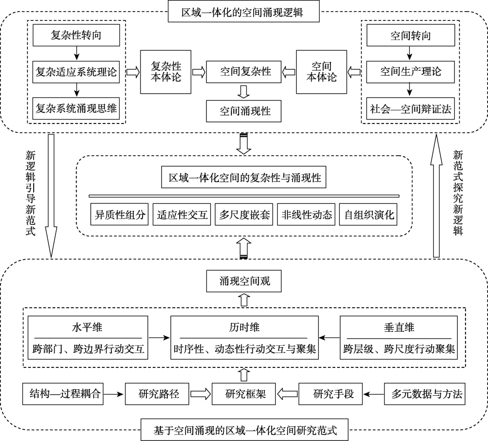
The implementation of major regional development strategies such as the integrated regional development in the Yangtze River Delta requires the support of the theoretical research on the systematicness and complexity of regional space. Complexity science and its emergence thinking are of great value to regional integration research, but it is difficult for the existing research to meet the needs of practical development and theoretical innovation. By using the methods of literature research, logical derivation, induction and summary and so on, based on the review of complexity research theory in geospatial space field, guided by complex adaptive system theory and from the perspective of complex system emergence, this paper explores the space-emergence logic and research paradigm of space evolution of regional integration and discusses the complex space governance of integrated regional development in the Yangtze River Delta following the clue of "theoretical logic-research paradigm-practice enlightenment". The results show that: (1) The regional integration can be conceptualized as a complex adaptive system, which is characterized by space complexity such as heterogeneous components, adaptive interaction, multi-scale nesting, nonlinear dynamics and self-organizing evolution with the essential attribute of space emergence. (2) The exploration of new space-emergence logic gives birth to the exploration of new research paradigm of integrated regional space, that is, to regard space emergence as the new logic and new thinking of integrated regional space research, to study space emergence mechanism with the horizontal-vertical-diachronical framework, to reveal space emergence and evolution dynamics by structure-process coupling path, and to pay attention to the integration of multiple data and methods. (3) Taking comprehensive governance as the general guidelines, we should conduct concrete strategies, from the aspects of governance subject, object, structure, tool and efficiency, to improve the spatial governance level on the target of the high-quality integrated development in the Yangtze River Delta.
In 2018, the integrated development of the Yangtze River Delta became a national strategy, aiming to break administrative barriers with integrated ideas and measures, and achieve the efficient flow of capital, talents, technology and other essential resources. As the main drive for innovation and knowledge-based economy, the reasonable allocation and orderly migration of talents are conducive to promoting regional integration and achieving high-quality development. Against this backdrop, this study focuses on the migration of university graduates, a vital component of regional talent resource. Based on data drawn from Graduate Employment Quality Report, we demonstrate the spatial patterns of graduate migration in the Yangtze River Delta and reveal the influencing factors underlying their migration by using the geographical detector model. The results show that the migration flow of graduates in the study area basically follows the law of reduction with the increase of distance and hierarchy, and the proportion of graduates who stayed and worked in the region reached 79.72%. The intra-provincial migration pattern is diversified in Jiangsu, Zhejiang and Anhui provinces. Cities with a higher retention rate are located in the "Z"-shaped zone and coastal areas. Shanghai and its nearby cities (Suzhou, Jiaxing, and Nantong) have formed a "high-high" cluster with a high retention rate. Furthermore, the results of factor detector show that innovation factors play a stronger role in affecting graduate migration in the delta region. However, the effect of these innovation factors differs among Jiangsu, Zhejiang and Anhui, with the strongest effect found in Jiangsu, followed by Zhejiang, while the insignificant effect in Anhui. The results of risk detector show that once the level of innovation reaches a certain threshold, its effects on attracting university graduates increase substantially. This study reveals the relationship between the migration pattern of university graduates and regional innovation, which provides theoretical and empirical basis for formulating policies to promote regional talent integration.
From a long-term perspective, innovation is the key driving force for economic growth. Under the background of China's economic transition from high-speed growth to high-quality development, the promotion of the innovation level is one of the important measures to achieve higher-quality economic development. A large number of studies conducted in-depth discussions on the spatio-temporal evolution and driving factors of the innovation development, and found that the inefficient allocation of innovation resources and the imbalance co-opetition relationship had become important factors restricting China's innovation development. Under the background of deepening integration, accurately grasping the innovative interactive relationship of urban agglomerations has important practical significance for promoting high-quality development. The spatial spillover effect is an important manifestation of the interactive relationship among regional innovation development. Based on the prefecture level data from 2000 to 2017 and spatial measurement methods, this paper conducts a multi-angle study on the spatial spillover effects of innovation development in the Yangtze River Delta. The results show that: (1) The innovative development had a significant positive spatial spillover effect of the Yangtze River Delta Urban Agglomeration. Overall, innovative talents, capital investment, economic development, transportation facilities, and opening-up were all important driving factors for innovation development, but different factors show differences in spatial spillover effect. (2) Comparing different regions and different periods, we found that there were significant differences in the spatial spillover effects of innovation development, such as stronger core regions and significantly enhanced temporal evolution. (3) Many studies had shown that the spatial spillover effect of innovation development was significantly affected by distance. This article found that the spillover effect exhibited an "inverted U" evolution characteristic with the increase of distance in the Yangtze River Delta, and the strongest spillover effect was found at a distance of 325 km, which showed that there was an optimal spatial boundary for urban agglomerations from the perspective of innovation. However, the spatial spillover effect fluctuated slowly when the distance exceeded 325 km, which was affected by the relatively balanced distribution of central cities. The research provides a new perspective for identifying the co-opetition relationship of innovation development about urban agglomerations, and has practical guiding significance for promoting the innovation development and deepening integration of urban agglomerations.
In the context of the growing gap between urban and rural development, this paper takes the Yangtze River Delta region as a research case and uses the Entropy method to calculate the development index for the 2008-2018 urban-rural integration and spatial integration, economic integration, social integration and lifestyle integration. And then it uses the Geographic Detector Model to analyze the main influencing factors and evolution characteristics of the level of urban-rural integration. The results show that the development level of urban-rural integration in the study region is characterized by spatial evolution from the "high-low-high" structure to a "Σ"-shaped pattern; from the perspective of the spatial characteristics of the urban-rural integration subsystem, the high value of the development level of spatial integration and the level of social integration presents the spatial pattern of a "Σ" shape, the economic integration development level is characterized as high and low circle structure, and the life integration development level roughly presents the spatial pattern of high in the west and low in the east. Seen from the results of the geographic detector model, the level of economic development, industrial advancement, the proportion of fiscal expenditures on agricultural support, and fiscal decentralization are conducive to the development of urban-rural integration; while the speed of economic development, the deviation of industrial structure, and the proportion of urban-rural infrastructure expenditures are not conducive to the urban-rural integration. From the temporal perspective, government power is gradually weakening, and market power is gradually intensifying.
Digital economy technology plays an increasingly important role in industrial transformation and high-quality economic development. Based on 41 cities of the Yangtze River Delta from 2011 to 2018, this paper analyzes the impact of digital economy on the high-quality development of the integration of the delta region, and creatively constructs an imbalance index of talent flow to explore the adjustment effect of the imbalance of talent flow in the region on the relationship between digital economy and high-quality development. The results show that the high-quality development level and the scale of digital economy in the Yangtze River Delta integration are increasing year by year. The development of digital economy has a positive impact on the high-quality development by improving the production efficiency, circulation efficiency and social convenience. The positive impact of non-core areas is stronger than that of core areas. The imbalance of talent flow will reversely regulate the positive impact of digital economy on the high-quality development, but this impact is only found in the core area of the Yangtze River Delta. In addition, digital economy has a negative spatial spillover effect with economic distance as the weight matrix.
As an important part of new urbanization, ecological urbanization is the concrete practice of ecological civilization concept. Taking 41 cities in the Yangtze River Delta as the research area, this paper constructed an index system of regional ecological urbanization, measured the development level of ecological urbanization from 2000 to 2018, and explored the spatiotemporal evolution characteristics of ecological urbanization and the mechanism of influencing factors. The results show that: (1) The overall level of ecological urbanization in the Yangtze River Delta region shows an upward trend, with high value areas gradually clustering in Zhejiang and low value areas concentrating in Northern Jiangsu and Northern Anhui. The gap of ecological urbanization index among cities is gradually narrowing, and the degree of regional ecological integration is continuously improving. (2) The spatial autocorrelation of ecological urbanization in the region gradually increases, and its spatial evolution is characterized by strong variability, dependence and integration. The spatial variability gradually weakens from west to east, and the dependence gradually increases from northwest to southeast. (3) The influence of financial investment level, income gap between urban and rural areas, industrial development level, land investment intensity, population density and scientific and technological development level on the level of ecological urbanization in this region decreases in turn. Under the comprehensive effect of many factors, the level of ecological urbanization in each city gradually converges. Under the combined effect of many factors, the level of ecological urbanization in each city gradually converges. Strengthening the construction of regional ecological integration and improving the level of regional ecological urbanization is an effective way to build a beautiful China and an inevitable choice to achieve regional high-quality development.
Low-carbon economy is the inherent requirement to achieve high-quality integrated development in the Yangtze River Delta. This paper analyzes the spatiotemporal correlation, allometric growth relationship, and driving forces between economic growth and carbon emissions in the Yangtze River Delta Urban Agglomeration from 2000 to 2017. The findings show that: (1) There exists a positive correlation between economic growth and carbon emissions in the study area, and the overall correlation intensity presents a "V-shaped" fluctuation. From 2000 to 2008, the areas with high correlation intensity were relatively concentrated in Southern Jiangsu, Northern Jiangsu and Central Zhejiang. From 2009 to 2017, the spatial correlation intensity decreased significantly, and generally presented a spatial pattern of "low in the south and high in the north". (2) The allometric variation between economic growth and carbon emissions is dominated by weak economic expansion, and the allometric relationship between economic growth and carbon emissions in most areas has turned from positive to negative. (3) The geo-detector diagnoses that the proportions of secondary and tertiary industries, as well as urbanization and population density are the main factors driving the allometric variation between economic growth and carbon emissions. (4) Multi-scale geographical weighted regression shows that the population density has an significantly negative impact on allometric variation between economic growth and carbon emissions, investment intensity and the intensity of fiscal expenditure have an inhibitory effect, urbanization and consumption level show the effect of first promoting and then offsetting, while the proportions of secondary and tertiary industries, and the carbon sequestration ability show the effect of first inhibition and then promotion.
Urban construction promotes urban collaborative development, which has an impact on carbon emissions, so studying the relationship between urban construction and carbon emissions can help explore an effective way to reduce emissions. This article, based on land utilization, energy consumption and other data from 2010 to 2018, Zhejiang province, calculates carbon emissions. We use spatial autocorrelation methods and space metering regression models to explore the spatio-temporal evolution characteristics of carbon emissions in four metropolitan areas and their influencing factors. The results showed that: (1) Hangzhou metropolitan area is the largest carbon emission urban area in Zhejiang, followed by Ningbo, Wenzhou and Jinhua-Yiwu. (2) In terms of spatial distribution, carbon emissions have significant agglomeration characteristics. Obvious spatial heterogeneity can be observed in metropolitan areas. The spatial aggregation of carbon emissions in different metropolitan areas have significant differences. (3) Urban construction helps the synergy and utilization of various cities and towns, promotes efficient configuration and utilization of resources, and then reduces carbon emissions. (4) The influencing factors and driving mechanisms for metropolitan carbon emissions are affected by urban development phases and characteristics, thus forming different spatial features. (5) Metropolitan low-carbon construction tasks and programs are determined by their unique carbon emissions driving mechanisms and spatial aggregation characteristics.
Under the strategic background of high-quality integration of Yangtze River Delta and ecological priority and green development of Yangtze River Economic Belt, it is of great significance to explore the high-quality green development of Yangtze River Delta Urban Agglomeration. This paper constructs a high-quality green development evaluation system from four dimensions of green core power, green innovation industry, green environment base and green development performance. Based on the methods of critical weighting, kernel density estimation, center of gravity standard deviation ellipse and other methods, the equilibrium state, equilibrium degree and equilibrium entropy of high-quality green development of 27 cities in Yangtze River Delta Urban Agglomeration are discussed. The results show that: (1) Generally, the high-quality green development level of the urban agglomeration presents a northwest-southeast pattern and the gravity is located in the east of the center of the region. There are obvious spatial differences in the high-quality green development, but there is no spatial polarization. (2) From the regional perspective, the overall level of high-quality green development is relatively balanced, but with relatively low innovative dimension. From the perspective of city, there is obvious provincial differentiation in the degree of equilibrium, and Shanghai and the cities in Jiangsu and Zhejiang are obviously better than Anhui province. Equilibrium entropy shows that most cities have advantages in coordination degree of high-quality green development and have certain development potential. (3) Innovation level, environmental quality, land intensification and modern industry are common obstacles to high-quality green development. Based on this, the main obstacle types of cities are summarized and their specific obstacles are defined too. Adhering to innovation driven development, building a modern industrial system, strengthening the governance of land space, promoting the intensive, efficient and sustainable use of land, and maintaining a reasonable degree of balance and coordination are the urgent tasks to further promote the high-quality green development in the Yangtze River Delta Urban Agglomeration in the future.
The rapid urbanization process in the Yangtze River Delta has affected the balance between the supply and demand of ecosystem services. In order to realize the integrated and high-quality development of the Yangtze River Delta, it is necessary to explore the impact of urbanization on supply and demand of ecosystem services. Therefore, based on ecological model, Pearson correlation, random forest, local spatial autocorrelation and other methods, this paper analyzes the impact relationship, sensitivity and spatial interaction between urbanization and supply and demand of ecosystem services, and finally proposes ecological management measures. The study found that the comprehensive level of urbanization in the Yangtze River Delta increased by 133.33% from 2000 to 2018; ESDR is positive but shows a decreasing trend, with an average decline rate of 22.39%; urbanization has a significant negative impact on ESDR, with an average increase of 82.34% from 2000 to 2018; food production is more sensitive to population urbanization, carbon storage and habitat quality are more sensitive to economic urbanization, and water conservation and PM2.5 removal are more sensitive to spatial urbanization. There is a large spatial mismatch between urbanization and ESDR. Therefore, it is suggested to divide the Yangtze River Delta into ecological utilization area, ecological reconstruction area, ecological source area and ecological restoration area, and proposes ecological optimization management measures according to the characteristics of urbanization and supply and demand of ecosystem service.
The relationship between environmental regulation and green development and its impact mechanism are complex and controversial. Based on the panel data of 41 cities in the Yangtze River Delta from 2003 to 2018, this paper first constructs a measurement index system to calculate the green development level and spatial dynamic evolution of each city. Secondly, using the stochastic impacts by regression on population, affluence, and technology (STIRPAT), this paper constructs a panel measurement model to explore the impact of environmental regulation on urban green development. The results show that: (1) The level of environmental regulation and green development in the study area shows an upward trend, but there are significant regional differences. The level of green development has been in a stable pattern of decreasing from southeast to northwest, and the focus of environmental regulation intensity has experienced a spatial evolution from southeast to northwest. (2) On the whole, environmental regulation can affect urban green development significantly, and there is an inverted U-shaped relationship between them, that is, excessive environmental regulation will inhibit the level of urban green development. (3) There is a close linkage between environmental regulation and technological innovation. Environmental regulation mainly affects urban green development through the intermediary path of technological innovation, in which the intermediary effect accounts for about 50.1% of the total effect. The research results can provide some enlightenment for promoting the integrated and high-quality development of the Yangtze River Delta. Local condition-based environmental regulation is the premise to improve the efficiency of urban green development, and pay attention to the promotion of the transformation of urban green development by improving the level of technological innovation.
The rapid urbanization intensified resources consumption. As the essential resources, the water-energy-food is the key for cities to achieve sustainable development. Taking the Yangtze River Delta Urban Agglomeration (YRD) as an example, this study constructed the WEF system stress index (WEF_SI), revealed the evolution characteristics of WEF stress in the study area during 1990-2018, and explored the influencing mechanism of urbanization on the WEF stress. The results showed that: The WEF stress in the YRD increased significantly due to the accelerated integration process after 2010. Although its overall downward trend was obvious, the stress of energy was still the dominant stress on the WEF system. Water stress was stable overall, while food stress surged after 2010. Due to the difference of the resources endowment, economic development level and urbanization process, there were obvious differences in evolution characteristics of WEF stress within the YRD. Urban spatial expansion, urbanization rate, economic development level and residents' consumption significantly affected the WEF stress. Therefore, WEF system management should be based on the evolution characteristics of different resources. Moreover, we should strengthen the supervision of resources consumption and the synergy management among different sectors and regions to promote the sustainable development of the YRD.
Realizing ecosystem service value is the prerequisite of the integrated implementation of regional ecosystem pattern. With the rapid development of China's economy, there are fewer ecological products that can meet people's increasing demand of better life. Guided by the conviction that lucid waters and lush mountains are invaluable assets, we advocate the priority of ecological protection and the new requirements for the realization of the value of ecological products; however, the problems such as inaccurate definition of ecological products and obstacles of trading mechanism are still prominent. The paper took Tianmu Lake Basin as an example and proposed a two-way interaction between the marketization of ecological protection and the improvement of ecological products value. Some conclusions can be drawn as follows: (1) The ecological products of water quality purification service were dominant in the study basin, which equaled the surplus part of the water quality purification service capacity subtracting the safety baseline part for the ecological health benchmark. (2) Based on the distributed hydrological model and water quality model of pollutant transport process, the supply and bottom price of ecological products were accurately calculated. The supply of water quality purification service products was estimated to be 1.37 tons, and bottom price was 11.87 million yuan/t/a, and the zonal price was between 11.87-71.05 million yuan/t/a. (3) According to the relationship between supply and demand of ecological products during the past 10 years, we identified five types of ecological trading mechanism, namely, the transboundary basin compensation (type A1), the ecological restoration (type A2), the agricultural abandonment for non-point source pollution (type B1), the agricultural management for non-point source pollution (type B2), and the ecological benefit payment (type C1). Then we designed a typical trading model between the freshwater shrimp cultivating abandonment and the leisure industry urgement: proposing the definition method of ecological products under the watershed ecological protection health benchmark and the trading unit transforming from non-point source pollution into point source, and realizing the multi-agent trading mechanism. This study was an innovative practice to use the international Payment Ecosystem Servives mechanism in China, which has generated multiple targets, including regional ecological value enhancement, economic benefit and the action of load-reducing for government environmental protection. It also provides a reference for the realization of the ecological product values in areas with developed economy and excellent ecological environment.
Under the background of ecological civilization construction, high-quality development and the establishment of territorial spatial planning system, it is of great practical significance to explore the synergistic relationship and improvement path among ecological protection, economic transformation and social transformation in trans-boundary regions for the implementation of regional or metropolitan integration development strategy in the new era. This article aims to improve the overall benefits of ecology, economy, and society, and comprehensively uses the entropy method and the coupling coordination degree model to analyze the development of the ecological, economic, and social subsystems and the level of coupling and coordination in the cross-border region of Pukou-Nanqiao, i.e., Nanjing-Chuzhou, from 2005 to 2019. Through analysis, it is found that the comprehensive development index of the two places basically shows a consistent growth trend, and the degree of coupling and coordination between regions and various subsystems has also developed to a higher level, but there is still a certain distance to the target stage of high-quality coordination, and the ecological subsystems. There are multiple regressions and fluctuations in the coordination degree between time and economic subsystems. It is necessary to formulate planning response strategies with regional coordinated development as the core content. The technical path proposed in this paper can provide a reference for the evaluation and improvement of the development level of transboundary regions at the meso-micro scale.
With rapid socio-economic development, the relationship between city and lake has experienced complicated and diversified changes, which brings potential challenges to regional sustainable development. To optimize the relationship between urban development and lake protection, this study, taking Hefei-Chaohu Lake in the Yangtze River Delta (YRD) as an example, established the evaluation index system of city-lake symbiosis, and analyzed the development levels and variations of Hefei and Chaohu Lake from 2005 to 2019, based on the theoretical analysis of city-lake symbiosis. Consequently, the symbiotic pattern of Hefei and Chaohu Lake was identified by introducing Lotka-Volterra model, and the variation trend of Hefei and Chaohu Lake symbiotic level was measured using symbiotic coordination degree model. The main conclusions and suggestions are as follows: (1) During the study period, the city subsystem showed a steady upward trend, and the level of each indicator gradually changed from great differences to balanced development. Although the level of scientific and technological innovation showed the fastest increasing trend, it was still lower than the other indicators. In order to further improve the level of scientific and technological innovation, it is suggested to enhance both the industrial transformation-upgrading and green innovation capability of Hefei. (2) During the study period, the lake subsystem showed a fluctuating upward trend, and the trend slowed down since 2014. The water ecological environment has been improved significantly compared with the levels of water pollution prevention and water resource security. However, the growth rates of all the three indicators have slowed down in recent years. Thus, comprehensive management and protection of Chaohu Lake is still one of the top priorities in the near future. (3) Although the results of the identification of symbiotic pattern show that Hefei and Chaohu Lake have already stepped into the stage of mutualistic symbiosis, the low value of symbiotic coordination degree indicates that both the city and the lake are still in the early stage. In addition to the improvement of the levels of both the city subsystem and the lake subsystem, it is suggested that the linkage and integration between Hefei and Chaohu Lake should be further enhanced to reach the high level of mutualistic symbiosis, and realize the harmonious development between human and nature. The study provides a reference for symbiotic pattern recognition and high-quality development of other city-lake systems in the YRD.
Following the rapid process of urbanization and transfer of many rural labors, cropland use presents new characteristics in the undeveloped area of the Yangtze River Delta. Studies on cropland use from the perspective of farmers are significant to rural governance and agricultural high-quality development. This study took villages in the cities of Yancheng and Nantong as case studies and used the methods of questionnaires and structural equation models (SEM) to analyze the behavioral intention and its influence mechanism. The results show that behavioral intension of cropland use in Northern Jiangsu province had great differences among farmers with different cropland scales. The behavioral intention was mainly affected by the individual farmer and its family characteristics and cropland resource endowment. The policy perception and usage of technology and capital indirectly and weakly influenced the behavioral intention. It is urgent to carry out classified management and guidance of farmers, promote scale operation of cultivated land, strengthen skills training and policy learning, and explore new models of agricultural services for accurate and efficient management of cultivated land, agricultural high-quality development and rural revitalization.