To develop the marine economy and build a strong marine country, we need to care about, understand and manage the ocean from the perspective of national strategy. In order to systematically understand China's marine resource economy and strategy under the background of marine ecological civilization construction, nine well-known experts from marine-related fields were invited to discuss marine ecological civilization construction, marine land space planning, marine ecological pasture construction, and coastal ecological restoration. They conducted exchanges and interviews in frontier research fields such as marine strategic emerging industries, marine science and technology development, deep-sea mineral resources development, marine geopolitics, and China's participation in global ocean governance. According to their interviews: (1) The construction of marine ecological civilization is an important part of the construction of a powerful marine country. In the construction of marine ecological civilization, we should clarify the goal of building a beautiful ocean, master the methods of marine ecosystems, adhere to the major strategy of coordinating land and sea, and build an institutional system for marine ecological civilization. (2) National marine space planning should integrate existing sea-related plans, rationally develop, utilize and protect marine resources, innovate planning technologies and planning governance concepts, and strengthen marine space control indicators, marine space development capabilities, and local characteristic mechanisms for marine space governance, etc. (3) The construction of marine ranches should focus on the industrial chain and promote the construction of "all-for-one" marine ranches; strengthen the original drive, build an "all-for-all" marine ranch technology system; advocate integrated development and cultivate new "all-for-one" marine ranches. (4) Coastal ecological restoration based on "natural restoration" emphasizes the use of technologies to optimize the spatial layout and resource management of land-ocean staggered areas, fully consider the process and mechanism of natural restoration of coastal ecosystems, and improve the efficiency of ecological restoration. (5) The development of marine strategic emerging industries should grasp the general trend of the digital economy, focus on the development of intelligent manufacturing, accelerate the upgrading of the industrial structure, adhere to green and low-carbon development, and actively connect with regional strategies. (6) The key tasks for the future development of marine science and technology are to focus on the new strategic fields of deep sea and polar regions, improve the real-time fine observation and forecasting capabilities of key sea areas, focus on the intensive use of marine resources and energy, and strengthen the research and development of key core technologies of marine engineering equipment. (7) In the development of deep-sea mineral resources, it is necessary to strengthen international cooperation, carry out multidisciplinary investigation, long-term monitoring, enhance the research and development level of deep-sea development technology, evaluate the environmental impact of deep-sea mining, reduce the disturbance of the deep-sea development process to the marine environment, and realize deep-sea mining and deep-sea environmental protection coordinated development. (8) China should implement a spatially differentiated and targeted marine geostrategy to serve the unification of the motherland, the maintenance of marine rights and interests and the utilization of marine resources, and the safety of marine transportation and ecological environment, so as to ultimately serve the construction of a community with a shared future for the ocean. (9) We should implement the "going out" strategy of China's marine spatial planning technology, actively promote the strategy of building a "node network system" in China's overseas parks, and implement the talent training and training strategy for the needs of the Belt and Road Initiative, in order to provide necessary space fulcrum and technical support for global marine governance.
The integration of multiple marine spatial plans is a necessary measure to realize the modernization of national governance system and governance capacity. Marine function classification is the basic standard for the compilation and implementation of marine spatial planning, and the establishment of coordinated and integrated schemes in marine function classification systems is a necessary condition for the integration of multiple marine spatial planning, which is of great significance to the promotion and implementation of marine territorial spatial planning. Therefore, this paper selects the classification of functional zones in marine function zoning, one of the most important plans in the marine spatial planning system in China, as well as the sea area use classification proposed by the Ministry of Natural Resources recently as standards for national territorial spatial planning. On the basis of the clarification of the coordination connotation of marine function classification system and the sea area use compliance, environmental quality standards compliance, we establish a method to judge the coordination of marine functional classification system from three aspects: The conformity of marine use, the conformity of environmental quality standards and the impact of development and utilization, and construct the coordination matrix of the classification of marine functional zones and the sea area use classification. The results show that there are 22 pairs of sea area utilization combinations with coordination types of "compatible" or "conditionally compatible", which should be the focus of mixed utilization or stratified utilization of sea areas in future territorial spatial planning.
The evaluation of suitability of land and space development in coastal zone and optimization of functional space layout are the scientific basis for advancing the strategic goal of land-sea coordination. Taking Hainan Island as an example, this paper constructs an index system for the evaluation of the coastal zone "potential-limitation" based on the analysis of environmental benefits and losses, and comprehensively uses the multi-factor product and spatial overlapping methods, which is suitable for the development and construction of the land space in the coastal zone of Hainan Island. Then we carry out an integrated evaluation, and identify four types of coastal functional spaces: "port-industry-city" area, coastal tourism area, agriculture, forestry, animal husbandry and fishery area, and nature reserve based on the functional space discrimination conditions. The research shows that the areas that are suitable for land space development in the study area generally present a spatial distribution pattern of "more on the west coast and less on the east coast". The areas of suitable, basically suitable, basically unsuitable, and unsuitable for construction are 1785.32 km2, 1724.57 km2, 812.86 km2, and 4051.67 km2, respectively; suitable and unsuitable areas overlap and intersect, which brings tremendous pressure to the development of coastal land space. The areas of the four types of functional space in the coastal zone is 1813.39 km2, 2138.26 km2, 1831.62 km2 and 2591.15 km2, accounting for 21.65%, 25.53%, 21.87% and 30.94% of the coastal zone area respectively. The functional space of the coastal zone presents a "circle", "bipole" and "multipoint" spatial pattern. Based on the summarized three types of typical functional space conflicts, the functional space has been adjusted and optimized, and the agglomeration and connectivity of various functional spaces have been enhanced. However, the same functional space between sea and land is not connected, and the sea and land are economically connected. There are still many land-sea contradictions and conflicts in the development of land and space. The research results point out the development or protection mode of various suitability grade areas, expand the application conditions of suitability, and also enrich the theory on the suitability evaluation of land space development.
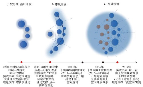
Sea-land coordination is an integrated task for optimizing the distribution of industries, space, people, resources, environment and other elements of the two major subsystems of sea and land. It is of great significance to ensure the efficient and coordinated development of coastal areas. With the emergence of the regional network development model emerged, a new round of territorial spatial planning has been gradually implemented. On the one hand, sea-land coordination has been given new connotations. On the other hand, sea-land coordination is facing new problems and challenges. There is an urgent need for an optimized path of territorial spatial planning in China's coastal areas under the "space of flows" paradigm. The paper combs the practice process and the evolution of related policies of sea-land coordination in coastal areas at home and abroad. And on this basis, the paper clarifies the conceptual connotation of sea-land coordination under the background of the new round of territorial spatial planning. Aiming to tackle the key challenges, the paper proposes a practical path to optimize the sea-land coordination. The study concludes that: (1) China's coastal areas have experienced a sea-land coordination practice and policy evolution path from "point" to "point-line" to "point-line-surface". Under the background of the new round of territorial spatial planning, the connotation of sea-land coordination is a "space of flows" strategic thinking that develops and protects all elements of the whole territory. Through unified planning of resource element allocation, industrial linkage, habitat co-governance, spatial interconnection and institutional inter-embedding of the two major marine and land systems, the coordinated and efficient development of coastal areas will be promoted, and the quality of production, life and ecological space will be improved. (2) As an important part of territorial spatial planning in coastal areas, sea-land coordination mainly faces four key challenges in practice: unclear sea-land spatial boundaries, uncoordinated sea-land economic systems, ununified sea-land resource development and habitat protection, and unbalanced sea-land spatial planning systems. Compatibility, at the same time, these are also the main cruxes of the disorderly development of space in coastal areas. (3) Practical path for sea-land coordination: clarify the boundary and target positioning of the overall plan; divide the functional space and optimize the spatial layout of the coast; build a systematic ecological protection system to improve the coastal ecological environment; coordinate the allocation of multiple elements to promote the coordinated economic development of coastal areas; improve planning system to ensure integrated management of land and sea. What needs to be pointed out is that any space-related mechanism and policy has scales. Undoubtedly, as a marine and land space development and protection strategy, sea-land coordination must have a scale. Sea-land coordination of different spatial scales has different strategic priorities and planning goals. Therefore, the scale conversion thinking should be strengthened when we formulate sea-land coordination policies. Finally, it is expected that the results can provide a reference for the coordinated development of sea and land in coastal areas of China.
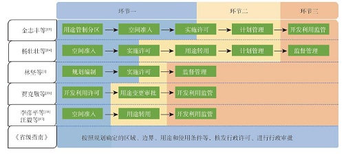
With the deepening of the structural reform of ecological civilization system, the control on the use of territorial space has been widely recognized as a solution to overcome the constraints of resource and environmental factors. Territorial spatial planning and use control features strong correlation, integrity and being carried out in stages, in terms of their content composition, function and implementation process, which makes the formulation of territorial spatial planning an important part in the implementation of use control. Currently, the research on marine spatial planning under the background of territorial spatial planning generally focuses on the integration of the concept and form of land and sea planning, but inadequate consideration of the particularity, complexity and independence of the sea has led to the deficiency of policy basis and technical guidance for the formulation of the sea-related planning in coastal areas. Therefore, it is of practical necessity and urgency to strengthen the study of marine spatial use control under the planning perspective. Through concept comparison and connotation extension analysis of use control, the core content of territorial spatial use control, namely zoning and control rules, is clarified and elaborated: (1) In terms of zoning, a three-level marine spatial zoning system is proposed, considering the compatibility of marine spatial functions/uses, sea-use diversities, the large-scale nature of development and utilization, and the negative regional externalities, etc. Based on the understanding of the purpose and the mechanism of territorial spatial zoning, it is believed that we should established a marine spatial zoning system on the basis of scientific understanding of the objective attributes and evolutionary laws of the ocean, and then put forward the technical logic of three-level marine spatial zoning based on "double evaluation". (2) In terms of control rules, firstly, coordination of the relationship between development and protection is identified as the current core mission of marine spatial use control, and then four basic questions faced are raised, namely, "how to protect", "how to use", "how to use in protection" and "how to protect in use". "Double evaluation" has the characteristics of constraining and developmental coupling in value orientation, which coincidently conforms to the 2-dimensional nature of marine development and protection. Therefore, we create a two-dimensional coordinate system, taking the importance of ecological protection as the vertical axis and the development and utilization demand as the horizontal axis, as a tool to elaborate on the policy and content orientation of the use control in different marine function/use areas. The above research is expected to support the deepening of the theory and technical methods of marine spatial planning and use control.
Offshore wind farms in deep-water area are characterized by great water depth, far from shore, and large scale. The reasonable planning of transmission spatial layout is directly related to investment cost and efficiency of sea use. And the calculation method of existing research only focused on two-dimensional (2D) plane, and the accuracy needs to be improved. In this paper, to draw a lesson from the idea of wind power gathering to islands and then sending out, a three-dimensional (3D) spatial layout optimization design model for offshore wind farms integration in deep-water area is established, and the wind farms in deep-water area of Eastern Guangdong is taken as an example in this study. The results show that: (1) The seafloor topography should be taken into account in deep-water wind farm integration. Although the sea bottom slope in the study area is very small, the total cable length of the optimized schemes is about 5% longer than that of the 2D plane. (2) The method of wind power gathering to islands and then sending out can effectively reduce the sea-area used and the total investment cost. And the largest reduction of sea-area used and total investment cost can reach 65%. (3) The lower the cable cost per unit capacity of different transmission modes, the closer the design scheme to the island-centered radiation pattern. The difference gradually decreases as the number of islands increases. The per unit capacity cost of the cable used for 220 kV alternating current (AC), 500 kV AC and ±320 kV direct current (DC) decreases in turn. When there is one island, the distance between the island and the collection center of the corresponding scheme is 38 km, 27 km, and 9 km, respectively. And when there are four islands, the distance is reduced to 19 km, 19 km, and 5 km, respectively.
As a major national strategy of China, land-sea coordination should not only realize the optimal allocation of land-sea elements at the national level, but also guide the spatial layout of land-sea industries at the regional level, so as to promote the coordinated development of the region. The current land-sea economy and land-space utilization research based on land-sea coordination is still in the exploratory stage, lacking systematic theoretical research and wide practical applications. Therefore, this paper discussed the research progress and existing problems of land-sea economic relations and land space utilization under the background of land-sea co-ordination from three aspects: Related concepts and theories of land-sea coordination, land-sea social and economic relations, coastal zone space utilization conflict and planning control. It is suggested that future research should focus more on multi-scale coupling and driving effect between land-sea resources and environment and land-sea social and economic development under the background of land-sea coordination, clarify the level of regional land-sea coordination and its evolution characteristics, influencing factors and response mechanism, pay attention to the diagnosis and control of coastal space utilization conflicts, and continuously promote the practice of coastal land-sea space planning based on land-sea coordination.
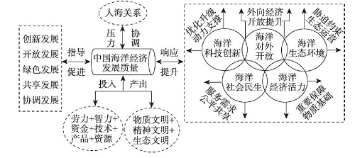
As an important strategic place, the ocean is of great significance to the development of a strong marine nation. Based on the data of 11 coastal provincial-level regions of China from 2006 to 2017, this paper uses set pair analysis, kernel density estimation model, standard deviation ellipse and GMM model to measure the quality of China's marine economic development under the background of high-quality growth, and its spatio-temporal evolution characteristics and influencing factors. The results show that: (1) Generally speaking, the quality of marine economic development from 2006 to 2017 showed an upward trend. In terms of space, there are three development levels: high, medium, and low; the national marine economic development presented a northeast-southwest pattern, and the center of gravity had always been located in the Yangtze River Delta region; regional differences in the quality of marine economic development were significant, consistent with the three major marine economic circles of the country, and the overall distribution is in a three-level pattern of north, east, and south. (2) All dimensions have achieved improvement of different degrees during the sample period, which are all indispensable parts of the high-quality development of the marine economy; the five dimensions are all showing a positive development trend. Provincial-level regions had different levels of dimensionality (high, medium and low), with significant differences. (3) Influencing factors, namely, marine location advantage, urbanization level, marketization level, industrial structure level, and land economic level had a positive effect on the marine economic development quality under a high-quality background. The utilization of marine resources and the intensity of environmental regulations have had a positive effect on the development of marine economy. The marine economic development quality had a negative inhibitory effect, and different influencing factors generated different effects in each marine economic circle of China.
This paper examines the spatial differentiation characteristics and distribution dynamics of marine economic development in China's three major marine economic circles and identifies the influencing factors of its spatial disequilibrium and spatial spillover, which can provide decision-making reference for optimizing the spatial layout of marine economic development and promoting the coordinated and balanced development of regional marine economy during the 14th Five-Year Plan period (2021-2025). We use Gagum Gini coefficient and its decomposition method to investigate the degree, source and evolution trend of regional relative differences in marine economic development in the three marine economic circles (hereafter three circles). The kernel density estimation method is further used to describe the distribution dynamic evolution process of absolute difference. And we apply spatial econometric analysis to identify the key factors of marine economic development and spatial spillover effects. The results show that: (1) The development level of marine economy in the three circles has shown a steady upward trend, however, there is a significant differentiation among the three. The overall development level of marine economy shows a spatial pattern of eastern circle > northern circle > southern circle. (2) There is a significant spatial disequilibrium degree of the three circles, with a rising fluctuation trend and a deeping regional imbalance. The degree of regional difference between the southern and northern circles is the largest, and the degree of regional difference in the southern circle is the first among the three circles. The overall difference is mainly due to the cross overlapping effect between groups, and the contribution of intra-group difference is higher than that of inter-group difference. (3) The "polarization effect" of the marine economic development level of the three circles is significant, which presents different types of polarization trends. The three major circles as a whole and the northern circle have gradually strengthened from polarization to multipolar differentiation. The spatial agglomeration effect of the eastern circle is enhanced. The southern circle has always shown a multi-level differentiation trend. (4) There is significant spatial dependence in the development of marine economy in the three circles, and the overall performance is characterized by positive spatial correlation. Capital, labor force, innovation driven, marketization and opening-up have positive regional spillover effect, while environmental regulation has negative regional spillover effect. Capital, labor force, innovation-driven force and marketization have significant positive interregional spillover effects, while environmental regulation and opening-up have no significant interregional spillover effects.
With the increasing economic potential and strategic value of marine resources, the exploitation, utilization and protection of international marine resources, especially high seas reserves, have gradually become the focus of marine countries. From the perspective of geo-economy and the connotation of marine community with a shared future, this paper analyzes the basic principles of international marine resources exploitation and utilization. Based on the classification of international marine economic activities, the theoretical framework and technical methods of international marine resources strategic value evaluation are put forward. Firstly, according to the distribution characteristics of international marine resources and the spatial pattern of economic activities, the international maritime economic activities are divided into three types: Punctiform economy, linear economy and planar economy. In addition to the factors such as marine ecological environment, marine natural conditions and international rules, national strategies and geographical relations, the development of various economic activities is also restricted by specific technical bottlenecks, equipment support and transportation costs. Secondly, based on the value attribute of commodities, three properties of the strategic value of international marine resources are proposed, namely natural attribute, social attribute and geographical attribute. Then, a three-dimensional spatial conceptual model of the strategic value evaluation of international marine resources is constructed from three aspects: Natural value, demand degree and availability. The boundary and threshold of exploitation, utilization and protection of international marine resources are determined by using marine carrying capacity. Thirdly, with oil and gas exploitation, maritime navigation and fishing as the typical representatives, the paper builds a trinity index system, integrates production function, demand function and other measurement models, and preliminarily establishes a relatively complete set of international marine resources strategic value evaluation technology method. Finally, according to the strategic needs of China's participation in global ocean governance, the countermeasures of speeding up the exploitation, utilization and protection of international marine resources are put forward.
The evaluation of marine space development suitability, an important part of marine spatial planning, is of great significance to the implementation of a coordinated development strategy in the Guangdong-Hong Kong-Macao Greater Bay Area. We developed a methodology to evaluate marine space development suitability based on ecosystem service. Lingdingyang Bay is divided into key development zones, restricted development zones, prohibited development zones and reserved zones, in a descending order of marine space development suitability, which account for 30.63%, 22.71%, 23.37% and 23.29%, respectively. The relationship between development suitability and ecological protection importance of these four zones are high-low, high-high, low-low, and low-high, respectively. According to the resource endowment and sea compatibility conditions, we divide key development zones into single-function zones and compatible zones. Single-function zones, located in nearshore and sea areas around the islands, are accessible separately to port shipping, tourism and fishery activity, while compatible zones, located around Guishan Island, focus mainly on the synergy of supply and cultural services. Restricted development zones include ecological tourism zones and recreational fisheries zones, which are distributed in the coastal waters of Hong Kong and Macao, focusing on the tradeoff between the development of supply/cultural services and the protection of regulation/support services.
Based on Landsat images, the spatial information of major gulfs along the coast of China in 2010, 2015, and 2020 were extracted to explore the morphological change characteristics. Some evaluation indexes, such as shoreline utilization degree, gulf area, gulf shape index, and gulf centroid, were used to analyze the gulfs' spatio-temporal change features in detail. The research showed that: (1) The shoreline length and structure of major gulfs changed significantly between 2010 and 2020, and the length and retention rate of the natural shorelines decreased. (2) The development and utilization degree of the gulf increased, with the increase rate gradually slowing down, and most of the gulf was moderately developed. (3) The gulf area continued to shrink, with a slow-down shrinking rate, and the gulf area in the Bohai Sea shrunk the most and the fastest. (4) The morphological change trend of the gulf is different from north to south. The north tends to be complicated, while the south to be simple. (5) After 2015, the gulf's plane center of gravity tended to be stable, the displacement distance decreased, and the displacement velocity slowed down. Human activities, such as sea reclamation, are the dominant factors leading to gulfs' morphological change. The national policies and measures for sea reclamation management and control in recent years have initially shown their effectiveness in affecting the gulf's morphology changes. The gulfs along the coast of China should be functionally positioned and divided, with refined classified management to optimize the layout of the "Ecological-Production-Living" space in the gulf areas.
The rapid erosion and deposition of tidal flat in alluvial island in estuaries due to the variations of land-sea sediments discharge has become the focus of urban development. Chongming Island, the largest alluvial island in China, has become an extremely valuable reserve land resource in Shanghai. However, the tidal resource in this island possibly presented new variation due to intensive human activities in drainage basins and estuaries. Accordingly, based on topographic data and measured bathymetric data around Chongming Island from 1984 to 2016, we illustrated the variation process of tidal flats in the study area through ArcGIS analysis and mathematical statistical analysis, and discussed the main factors influencing the geomorphic evolution of tidal flats. The results mainly include: (1) The process of erosion and accretion in each section of tidal flat around Chongming Island was complicated and varied. Totally, during the past three decades, the areas of the northern, southern and eastern beaches increased by 170 km2, 8 km2 and 51 km2, respectively. (2) Variation of the northern tidal flat was affected by land reclamation, which led to the shrinkage of the north branch and promoted the continuous growth of the tidal flat. (3) The deposition of Xinqiao channel and its northward movement to the island directly caused the expansion of the southern tidal flat. The eastern tidal flat was dominated by frequent reclamation projects. Owing to the continuous outward movement of the embankment, the tidal flat expanded greatly in the past decades.
The bay is a unique strategic and ecological space in the coastal zone. Under the influence of global warming and intensified human activities, the shape and ecosystem of the bay have become more sensitive, fragile, and changeable. It is particularly necessary to clarify the temporal and spatial differentiation characteristics of wetland evolution in the bay areas under the influence of human activities and to find out the root cause of the wetland resource endowment. With the increase of satellite remote sensing data and the development of geographic analysis platforms (i.e., Google Earth Engine, GEE), rapid, low-cost, high-precision continuous monitoring of the evolution of the land surface becomes possible. The analysis of the temporal and spatial characteristics of the evolution of the bay wetland is of great significance for clarifying the resource and environmental base of the bay, understanding the comprehensive development potential, and promoting the sustainable development of the bay area. Taking the Sanmen Bay Wetland (SBW) in Zhejiang province as the study area, using Landsat TM/ETM+/OLI remote sensing image data from 1984 to 2019, based on the change characteristics of the spectral index time series, we extracted the information of the study area to examine its dynamic changes. The results show that the area of SBW has changed significantly since 1984, mainly found in the south of Ninghai county, the northeast of Sanmen county, and the southwest of Xiangshan county. In terms of the area, there was a fluctuating downward trend from 1984 to 2002, an accelerated downward trend from 2003 to 2009, and a steady development trend from 2010 to 2019. Human activities, such as reclamation, have caused significant changes in the shape of the bay, and the supply process of coastal zone management policy has become one of the important factors in the evolution of the bay wetland. The research can provide decision support for the construction of the bay area and the sustainable development of coastal areas in the future.
Coastal erosion is one of the major challenges in coastal zones. Coastal landscape, tourism and leisure functions have been seriously affected by coastal erosion in many tourist sand beaches. Artificial nourishment on regular tourist beaches is of great importance for maintaining beach grade and promoting sustainable tourist development. Based on analysis of coastal dynamics, sediment and beach conditions, as well as comparison of remote sensing images and beach profiles, erosion conditions and origins of erosion are examined on the east section of Sanya Bay, Hainan Island, China. Artificial beach nourishment that does not shift coast nature was proposed for restoration and preservation of the beach, concerning the scenic urban area. By analyzing beach landform, dynamics, native and borrowed sand conditions, we designed a beach nourishment project, with the goal of proving resistivity to erosion and increasing the material sediment supply of the beach. Comparison of satellite images and fixed beach profiles before and after beach nourishment shows that the beach was restored and broadened as designed. Profiles measured one and a half years after nourishment show that the nourished beach face and berm were relatively stable, without an obvious increase in the rate of sand loss. The east section of Sanya Bay is a relatively calm area sheltered by the Luhuitou Peninsula. Beach erosion is mostly induced by a decrease in foreign sand supply and enhancement of local dynamic forces due to sandbar reclamation, construction of hard structural revement and artificial islands. Weakening dynamic forces to reduce sand loss and/or adding an effective supply of foreign sediment by artificial measures are necessary ways to restore and protect the beach. However, hard structures like groins and breakwaters will have a negative effect on both the coastal landscape and tourists' safety. The proposed beach nourishment project does not modify the beach nature, which is a reliable choice for beach restoration in Sanya, a famous tropical tourist city in China. Practice of the beach nourishment project indicates that beach nourishment with suitable location, range and borrowed sand following the natural coastline, landform and hydro-dynamics is effective for restoration of beach erosion of the east section of Sanya Bay. However, beach nourishment is not efficacious forever. Sand loss is still inevitable after nourishment, because the hydrodynamics have not changed. Further sustained re-nourishment is necessary to maintain the dynamic stability of the beach. Meanwhile, no strong typhoon hit the area during the surveys after nourishment, further response of the beach to storm waves are to be concerned.
As important habitats, mangroves are a pool of benthic spawning genes and the biodefense line that intercepts continental pollutants. Ocean plastic pollution could lead to serious physical and toxicological effects on marine life and further threaten the stability and well-being of mangrove biodiversity. This study adopted methods of quantitative field observations and qualitative marine sampling. We, taking Qinglan Port, Hainan Island as the study area, collected marine waste, sediment and benthic organisms as the subjects of research. Visual identification, stereomicroscope observation and infrared spectrum analysis were used during the process to analyze features and sources of serious plastic waste. The findings show that the main plastic wastes include plastic bags, foams and fishing waste. Microplastics are a combination of flakes, fibers, lines, films, particles and spherical shapes, most of which are fabrics as a result of physical compression. The purpose of this study is to provide decisive suggestions to the government departments concerned for management and policy development to ensure maximum protection of mangrove forest habitats and their surrounding environments.
Global warming induced sea level rise is a hot topic in the field of land-sea interaction. Coastal erosion and flooding caused by sea level rise pose a great threat to the environment and economic development. We examined the spatial-temporal distribution characteristics and potential social and economic risks of sea level change in China's coastal areas from 1993 to 2018 based on the sea-level anomaly (SLA) data and the shared social and economic path scenario (SSPS). The results showed that: (1) During the study period, the average annual sea level and extreme sea level in the study area showed a significant rising trend, with the rate of change reaching up to 3.47±0.50 mm/a and 4.74±1.39 mm/a, respectively. (2) The rising rate of the four major sea areas of China is listed is as follows: East China Sea > Yellow Sea > Bohai Sea > South China Sea. In terms of the provincial scale, Jiangsu, Fujian and Zhejiang have higher sea level growth rates, while Guangdong, Shanghai and Taiwan have lower sea level rise rates. (3) The results of MK test and Sen trend analysis showed that the average annual sea level had a significant increase trend in the whole study area. Specifically, 84.16% of the area had a moderately slow growth rate and 2.32% of the area was going fast. As for the extreme sea level, areas with a significant increase accounted for 76%, of which 59.65% had a slow growth and 2.31% had a fast growth. During the study period, there was no significant reduction in the area. (4) In terms of spatial volatility, the sea level change over the past decades had been at a relatively low volatility level. According to statistical results, the lower volatility area accounts for 61.31%, while the highest and higher volatility areas only account for 3.17%. (5) By 2100, under three shared social and economic development paths (SSP1, SSP2 and SSP3), the potential economic losses in Chinese coastal areas will reach 10-21 trillion yuan, and the population affected by sea level rise is about 3.5-5.5 million. From the provincial perspective, Guangdong has the largest flooded area (accounting for 0.7% of the total land area of the province), and the highest economic and population risks. Therefore, mitigation and adaption to the risk of sea level rise is an important task for maintaining sustainable socio-economic development, resources utilization and environmental protection in China's coastal areas in the 21st century.
The IPCC special report on global warming of 1.5 °C and the IPCC special report on climate change and land both identify aquaculture as one of the key sectors that requires attention on global food security and the upgrading of adaptation policy. Research on the disaster-adaptive behavior and its influencing factors at the farmer level is of great value for enhancing the adaptive capacity to disasters, ensuring the livelihood of aquaculture farmers, and the sustainable development of islands, so as to revitalize fishing villages. However, very few studies have been conducted at the farmer level. Using survey data obtained from 202 aquaculture farmers from the Zhoushan and Dongtou Island regions and applying multivariate probit model, this study analyzes the disaster adaptation strategies of aquaculture farmers during the whole process of disaster management and the influencing factors. The results showed that: (1) Diverse multilevel adaptive strategies were adopted in study areas to deal with typhoon disaster. Up-front strategies, simple early strategies and future-benefits strategies were used significantly less than no-regret reaction and low-regret tactics by aquaculture farmers, making most farmers' adaptation strategies less effective. More than half of the farmers are willing to adopt the up-front, simple early and future-benefits strategies in the future if conditions facilitate usage of these strategies. (2) Each factor affected adaptation strategies of aquaculture farmers negatively and positively at the same time, and there was also significant complementary and substitutive relationship among the adaptive strategies selected by the aquaculture farmers. (3) Age, family labor, and the number of disasters occurring in the past 5 years were important factors influencing aquaculture farmers' adaptive behavior. Input, health status, disaster perception, income, education level, and social capital also had a significant impact on farmers' adaptive behavior. (4) Some influencing factors and their effects on the disaster adaptation behavior of aquaculture farmers in Zhoushan Islands and Dongtou Islands were different from those in other regions, which highlight the uniqueness of island regions. This study identifies the key influencing factors and weakness of adaptation behavior toward typhoon disaster, and the conclusions provide useful insight into the optimization and adjustment of the government and farmers' adaptation strategies.