Natural resources play an important role in a country's development. Since the 19th National Congress of the Communist Party of China (CPC) in 2017, China has attached great importance to the management of natural resources. China's natural resource management systems, institutions, concepts and methods have been constantly reformed and innovated, and management systems and models that are more suitable to China's national conditions have been gradually formed, with remarkable results. However, there are still many inadequacies and contradictions in management practice. Starting from current situations of China's natural resources management system and institutional construction, this paper expounds the difficulties in developing natural resources management system and institutional construction from three aspects: management object, management subject, and management guarantee; summarizes prominent practical problems that restrict the development of management practice at present; and finally provides thinking and suggestions for China's natural resource management system reform and institutional construction in the future from two aspects: constructing the multi-dimensional natural resource management system and perfecting the natural resource management system under the perspective of national security. This will help further promote China's sustainable development and ecological civilization construction in the future.

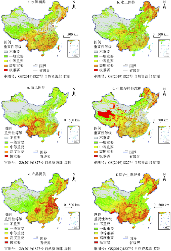
Natural resources are essential for ensuring economic and social development, and also provide important ecosystem services. This study selected five types of ecosystem services, including water conservation, soil erosion prevention, windbreak and sand fixation, biodiversity maintenance and product provision, and used NPP-associated index to determine the importance of natural resource ecosystem services in China. The spatial pattern of the importance of ecosystem services were then analyzed using spatial statistics methods. The results showed that the areas with extreme and high importance of natural resource ecosystem services are mainly distributed in the mountainous areas of Northeast China, the Southern and Southwestern parts of China, and the Eastern Qinghai-Tibet Plateau, accounting for about 25% of the country's total area. These areas were often characterized by high water conservation capacity, strong capability for soil erosion prevention, windbreak and sand fixation, and rich biodiversity. There were significant differences in the importance of ecosystem services among different natural resource types. Cultivated land resources played an important role in providing products; forest and grassland resources dominated the ecosystem services of water conservation, soil erosion prevention, windbreak and sand fixation, and biodiversity maintenance; water areas mainly provided the service of water conservation. The importance of ecosystem services showed a significantly clustered pattern. The hot spots of natural resource integrated ecosystem service are mainly distributed in the Da Hinggan Mountains, Changbai Mountains, Zhejiang-Fujian Mountains, Wuyi Mountains, Nanling Mountains, Qinling Mountains, Southwestern Yunnan, and Southeastern Tibet. The spatial distribution of the importance of integrated ecosystem service in China is highly consistent with the natural zones and subzones of agriculture, with higher level of importance in tropical and temperate regions. Our research provides sound decision-making support for the exploitation and management of natural resources, and is also useful for ecological protection and restoration.
Based on statistical core journals and core scholars, this paper uses softwares such as CITESPACE, ORIGN, and Data-Driven Documents, to review the development of research, sort out hotspots and put forward research prospects on resource and environmental carrying capacity (RECC) assessment in China in the past 35 years. The results show that: (1) The evaluation of RECC in China follows the trajectory of "single factor", "multi-factor" and "dynamic integration", and the applied research evolved from "population capacity", "unilateral problem of regional development (RD)", to "multifaceted problem of RD". (2) According to the logic of "scientific evaluation - mechanism disclosure - practical application", this paper points out that, scholars mainly used the index system method, comprehensive evaluation method, footprint method and other methods to estimate the bearing capacity. Based on the calculation results, scholars summarized the spatial and temporal distribution of carrying capacity, identified the impact factors, and revealed the mechanism, to play a supporting role of carrying capacity in promoting regional economic development, speeding up new urbanization, optimizing territorial space, monitoring, early warning, simulation and prediction. (3) Based on the above, it is suggested that the following four aspects should be further optimized, namely, interdisciplinary research, specificity and advancement of evaluation indicators, depth of mechanism disclosure, and dynamics of carrying capacity evaluation.
Unifying the use regulation is the core objective of natural resources management. However, there remain several problems in current use regulation of natural resources, including unclear division of authority, non-uniform dimension of indexes, overlap of regulatory space, lacking of supervision and assessment. These problems are necessary to be synthetically researched from logical framework and systematic compositions of use regulation. The logical framework approach (LFA) is a method that starts from problems and converts broad objectives to specific goals and measures. Applying this approach, this paper built the logical framework of "broad objectives-specific goals-problems posing-regulatory measures-assessment and supervision" based on the analysis of fundamental connotation for use regulation of natural resources. Finally, it offered suggestions on specific measures, assessment and supervision of natural resources management.
The research on the structure of tourism flow network driven by big data is one of the main directions of deepening research. By using web crawler technology to capture travel routes and related data on Ctrip, and then constructing a 299×299 tourism flow of O-D matrix in Chinese cities, this article reveals the spatial differentiation and effects of network structure. The results show that: (1) The tourism flow network homogeneity is small in Chinese cities. Tourism flow of different themes follows the overall pattern of "more in the east and less in the west, and more in the southeast and less in the northwest". The high-value areas of the network degree are mainly concentrated in the Yangtze River Delta Urban Agglomeration, the Chengdu-Chongqing Economic Circle, as well as Yunnan province and its surrounding areas. A low-value "depression" is formed in Northeast China. (2) The tourism flow network has obvious group characteristics in Chinese cities. It has formed five high-value agglomeration areas, namely: the Yangtze River Delta Urban Agglomeration (one strong and multi-super network), the Pan-Pearl River Delta Region (multi-core series network), and Yunnan (closed quadrilateral network), Qinghai-Gansu Junction Area (multi-node and fan-shaped network), and northern Xinjiang (node-series network). (3) The tourism flow network has significant resource-economic orientation in Chinese cities. The distribution of high value of tourism flow under different themes has the characteristics of "along the line and besieged city". Whether a node can have an advantageous "position" in the network is affected by the "push-pull" force of regional economy and tourism resources. (4) Generally, the "structure" effect is not obvious in the tourism flow network of Chinese cities. On the one hand, the network structure index has significant power-law characteristics, making the network structure advantage embodied in a few nodes; on the other hand, according to the average value of the network node degree and the number of tourists, the relationship between them can be identified into 4 types: high-high type, low-high type, low-low type, and high-low type. Most of the nodes are at a disadvantage position in the network. The high-quality development of tourism in the period of "14th Five-year Plan (2021-2025)" must attach importance to the development trend of networking characteristics of urban tourism, and reasonably arrange tourism elements according to the networking characteristics. For one thing, we should pay more attention to the development law of tourism flow network, promote cross-regional tourism cooperation; for the other, we should give full play to the radiation role of the core group and the dual-core drive of "resource-economy" of Chinese urban tourism.
With unique tourism resources, the Antarctic attracts more and more attention, and the number of tourists to the region is growing rapidly. However, there have been fewer studies on the Antarctic tourism resources, and the research on the classification and evaluation of its tourism resources is almost blank. In this paper, the classification and spatial distribution of the Antarctic tourist resources are studied, and suggestions for the development of Antarctic tourism are put forward, in order to provide a reference for evaluating, developing and conserving these tourism resources. Results show that: (1) In the Antarctic region, substantive tourist activities have been carried out in 558 major tourist resource units, which can be divided into 8 main types, 18 sub-types and 30 basic types according to different attributes. (2) There are diversified natural tourism resources, among which water landscape occupies a large proportion. (3) The tourism resources are unevenly distributed and typically characterized by aggregated distribution, and two high-density clusters are formed in the Antarctic. One is the coastal areas of Graham Land in the northwest of the Antarctic Peninsula and their surrounding islands, and the other is the islands and continent areas near the Ross Sea. (4) Climatic condition and the accessibility of tourism resources are important factors affecting the spatial distribution of Antarctic tourism resources. (5) There are less Antarctic tourism resources related to China, and China's participation and maturity in the development of Antarctic tourism are relatively low. In the future, China should find out the status of Antarctic tourism resources as soon as possible, strengthen the research on the impact of Antarctic tourism, and promote the development of China's tourism to the Antarctic.
Since the 21st century, China's rural social and economic development and infrastructure construction have attained remarkable achievements, but the imbalance between urban and rural development and inadequate rural development are still prominent. In particular, the living environment closely related to rural life is still the short board of rural development. At the beginning of 2018, the central government issued the three-year action plan for rural living environment improvement (RLEI) to focus on improving the rural living environment, building a beautiful and livable village, and pursuing the Rural Revitalization Strategy. This paper analyzes the concept and connotation of RLEI, explains the mechanism of RLEI promoting rural revitalization, combs the mode and mechanism, effect and evaluation of RLEI, and discusses the key areas of strengthening the research of RLEI. The science of rural living environment has developed rapidly in the past 10 years, and has made remarkable progress in basic theory, evolution mechanism, quality evaluation, regulation and control strategy, especially in the research of basic theory, evolution mechanism and quality evaluation. However, there are still obvious deficiencies in the guidance and support of the current research for practice, and there are still some misunderstandings in the practice of local specific RLEI. Facing the strategic needs of rural revitalization, we need to form "eight consensus" in the understanding and practice of RLEI in the new era. In terms of research, we should strengthen the intersection and integration of rural geography and engineering technology science, urban and rural planning science, management science, sociology, etc., and strive to form a systematic research system integrating theoretical research, technological development, mechanism analysis, effectiveness evaluation, and model optimization, which can better support the improvement of rural living environment and realize the function and value enhancement of rural areas, and then effectively contribute to the Rural Revitalization Strategy.
Based on the Meta-analysis method, the study revealed the spatio-temporal patterns and influencing factors of the hollowing village reclamation potential in China, and analyzed the hollowing village formation mechanism. The results show that a total of 344 counties have recorded hollowing villages from 1996 to 2019, mainly located in 29 provincial administrative units, such as Henan, Shandong, Hebei, Shanxi, and Hunan. There was a significant positive correlation between the value added of literature on hollowing village and the value declined of rural resident population. The hollowing village's reclamation potential grade had obvious characteristics of "high in the north, the plains and traditional agricultural areas, but low in the south, the hilly areas and urban agglomerations". The key factors influencing the reclamation potential included the rural natural geographical conditions, the number of rural residents and per unit cultivated area. Some 89.80% of the counties adopt intra-village intensification model, which were concentrated in the Huang-Huai-Hai Plain, the middle and lower reaches of the Yangtze River, the eastern part of the Sichuan Basin and its surrounding areas. More than 50% of counties employ village integration and the urban-rural integration models. The relocation models were mainly applied in the ecologically fragile and provety-stricken areas near the Hu Huanyong Line. This study provides reference for the implementation of rural land consolidation and rural revitalization strategy in the new period.
In the process of ecological migration, the displacement of living space of migrants leads to the interaction and long-term evolution of the economic, social, cultural, geographical and environmental factors of the migration area and emigration area, which has become an important part of multidisciplinary inquiry problem. Taking the ecological migrant community in Minning town as the research object, the relevant data information was obtained through the questionnaire, and the influencing factors and mechanism of the living space integration of the ecological migrant community were studied by principal component analysis method and geographic detector analysis method. The results show that: (1) The principal component analysis indicates that the influence of living infrastructure, economic income growth, migrant community environment, neighborhood relationship, government policy and "national life" on the integration of living space in ecological migrant communities can be explained. (2) Factor detection shows that the explanatory factors affecting the living space of the ecological migrant community are ranked in the order of X1 living infrastructure>X2 economic income growth>X3 neighborhood relationship>X4 government policy>X5 national life>X6 migrant community environment. The results of interactive detection show that the explanatory power after factor interaction was enhanced bilinear, that is, the interaction of any two factors on the spatial fusion of ecological migration community is greater than that of a single factor. (3) The interaction between the influencing factors promotes the reconstruction of the inherent living customs, cultural beliefs and social relations of the ecological migrant community.
Currently, Beijing, Shenzhen, Wuhan and other cities have put forward multi-center development ideas. As a crucial measure of urban construction, polycentric strategy must conform to the goal of sustainable development. Nevertheless, whether polycentric structure can improve the energy efficiency and promote the sustainable development of cities needs to be urgently tested. Based on the 2017 data of the prefecture-level and above cities in China, this paper respectively uses the improved social network method and the super-efficiency EBM model to measure urban polycentricity and urban energy efficiency, and empirically examines the impact of polycentric structure on urban energy efficiency. The results present a U-shaped pattern between urban polycentricity and urban energy efficiency. However, only about 25% of the sample cities can pass the inflection point, and they are mainly large cities or mountain cities constrained by terrain, indicating that for most small and medium-sized cities, the improvement of polycentricity can promote the energy efficiency of cities.
The natural resources balance-sheet is a brand-new subject with Chinese characteristics, and both its theory and practice are developing in the exploratory stage. This study creatively combined the ecological footprint theory with natural resources asset accounting and established a land resources asset accounting system by improving the ecological footprint model parameters, supplementing the calculation of value, and redefining the types of natural resources assets. Taking Xinjiang as a research target area, this study examined the changes in its land resources assets. The results show that: (1) There were interannual fluctuations in the parameters of the improved ecological footprint model in Xinjiang. The multi-year average of the equilibrium factor was listed in an order of water area (12.239)>wetland (10.161)>forest land (3.352)>grassland (0.990)>cultivated land (0.775)>desert (0.215). The multi-year average of the yield factors was wetland (1.234)>cultivated land (1.214)>forest land (0.889)>grassland (0.819)>water area (0.674)>desert (0.385). (2) Affected by product output and market price, the unit price of different land types in Xinjiang from high to low was as follows: wetland (1910309 yuan·hm-2)>forest land (329571 yuan·hm-2)>water area (213303 yuan·hm-2)>grassland (212176 yuan·hm-2)>cultivated land (165467 yuan·hm-2)>desert (40395 yuan·hm-2). (3) Xinjiang's land resources assets have increased steadily, equity has continued shrinking, and liabilities have been expanding. Within 18 years, the quantity and value of land resources assets increased by 27.19% and 48.19%, respectively; the quantity and value of equity decreased by 6.60% and 1.27%, respectively; liabilities expanded at a rate of 1.20×10⁶ hm2·a-1 and 2.56×10¹¹ yuan·a-1 in quantity and value, respectively. (4) The method of land resources assets accounting based on ecological footprint has the advantages of covering quality attribute and rich value content as well as avoiding repeated accounting. The research results can provide a case for the organic combination of ecological footprint and natural resources balance-sheet. At the same time, it will contribute to the rational utilization and scientific management of land resources in Xinjiang.
Land use system, as the key carrier of human interaction with nature, plays an important part in the process of regional sustainable development. In order to analyze its relevance to the United Nations Sustainable Development Goals (SDGs) and explain its support capacity, this paper constructs the connotation analysis framework of land use system, explores its supporting mechanism for SDGs and establishes the support capacity evaluation system for sustainable development, taking Shandong Province as an example for empirical analysis. The results show that: (1) Taking the land use system as the core, in the perspective of the relationship between human and land and its interactions with society, economy, ecological system, we analyze its operational mechanism in the coupling system of person, reveal its correlation with sustainable development, to determine the land use system of SDGs to provide theoretical analysis. (2) The support capacity of the land use system in Shandong province is distributed as "low in the east, but high in the west of the province; while high around the low surroundings of the urban center". During the study period, 66% of the support capacity was improved, and the change of support capacity showed the phenomenon of "uplift in the northwest and decline in the central and eastern regions". The direct support and self-stability of SDGs in the western plains with agricultural advantages has decreased, while the indirect support capacity has decreased, and the self-stability of the eastern economically developed areas has improved, while the direct and indirect support capacity has decreased. (3) The spatial correlation of each type of support capacity is significant. The significant areas are mostly distributed in the municipal districts. The radiation-driven agricultural development capacity of Heze city is strong. The economic output and social supply capacity of Dongying city are high-high agglomeration, and the stability of the land itself is low-low agglomeration. The research puts forward a new perspective on the sustainable development of land use system, which can provide reference for follow-up research, and empirical analysis lays a foundation for development decision-making in Shandong, and provides suggestions for the policy regulation of national spatial planning.
Advancing industrial transformation and upgrading and improving green total factor productivity are the key to promoting the high-quality development of resource-based cities in China. However, whether industrial transformation and upgrading can improve green total factor productivity has been controversial in academic circles. Focusing on 116 prefecture-level resource-based cities in China from 2003 to 2018, this paper analyzes the evolutionary characteristics and interactive relationship between industrial transformation and upgrading and green total factor productivity improvement. The results are as follows: (1) 56.9% of resource-based cities have implemented unsatisfactory industrial transformation and upgrading, and are in unbalanced state or double-low state between advanced and industrial structure rationalizations; 57.8% of resource-based cities have achieved positive growth in green total factor productivity, but the average annual growth rates of green total factor productivity in some resource-based cities increased slowly due to unimproved technological inefficiency. (2) The estimation results of PVAR model and impulse response show that there exists a time lag in the negative impact of green total factor productivity improvement on itself. At the same time, the long-term impact transmission mechanism is that after receiving the negative impact from the Theil index, an indicator to reflect industrial structure rationalization, the green total factor productivity improvement has a continuous positive effect on the industrial structure advancement. Then industrial structure advancement continuously imposes a positive effect on itself. (3) According to the analysis of variance decomposition forecast, green total factor productivity improvement, as well as industrial structure advancement and rationalization are mainly dependent on their own development paths. It can be seen that the explanatory power of the industrial structure advancement for green total factor productivity improvement is higher than that of the industrial structure rationalization. With the increase of periods, the mutual explanatory powers of both industrial structure advancement and green total factor productivity improvement gradually increase.
Green growth is a sustainable development mode to realize the coordination between human and land, which plays an important role in promoting regional green development and ecological civilization construction. Taking Shaanxi province as an example, based on the systematic analysis of the connotation and characteristics of green growth, this paper constructs the mechanism framework and evaluation index system of green growth system, and analyzes the spatiotemporal evolution characteristics and influencing factors of urban green growth level from 2008 to 2017 by using TOPSIS grey correlation analysis and Theil index. The results show that: (1) The level of urban green growth in Shaanxi province presents a "rise - drop - rise" fluctuation process. (2) In terms of spatial distribution, there are obvious regional differences in the level of urban green growth, and there is a trend of further expansion; in terms of spatial evolution, the intra-regional differences show a slight downward trend, while the inter-regional differences have an obvious upward trend. (3) Regional ecological environment (X3), quality of life environment (X4) and policy support environment (X5) are the main obstacles to the green growth level of Shaanxi, and there are obvious spatial differences in the barrier effect of different standard layers among cities. (4) On the provincial level, the five factors that hinder the level of urban green growth are the treatment capacity of waste gas treatment facilities (X43), the decline rate of energy consumption per unit GDP (X31), the number of employees engaged in scientific research and technical services (X54), the green coverage rate of built-up areas (X49), and the comprehensive utilization rate of general industrial solid waste (X42); on the urban level, X54 has the strongest blocking effect, followed by X43, X31, the number of buses and taxis per 10000 people (X48) and the per capita GDP (X21). (5) In the aspect of external environment driving, industrial structure, scientific and technological innovation ability contribute the most to Shaanxi's green growth, followed by trade level, marketization level, urbanization level and population density. Finally, the paper puts forward countermeasures and suggestions from five aspects, such as building a diversified energy structure system, improving green growth related policies and systems, and optimizing external environmental conditions.
This paper uses a multi-regional input-output table in conjunction with the global value chains (GVC) method to estimate the transfer of virtual fertilizers via China's global trade of agricultural products. The virtual fertilizers are divided into four types according to the form and the geographical location of agricultural products where they are finally consumed. We found that China's agricultural imports saved 6.4 million tons of fertilizer, accounting for 13% of China's fertilizer use) and saved 2.85 million tons of fertilizer globally, which alleviated global resource and environmental pressure. China's agricultural trade was deeply involved in the global value chains, and about 12% of the fertilizers imported through agricultural products were re-exported to other countries, which means that the resources embodied in the agricultural trade were exported again after arriving in China formed multiple cross-border transfers. It is suggested that the amount of fertilizers and other resources and environmental problems implied in agricultural trade should be estimated more objectively from the perspective of the global value chains, and the global community should share the resource and environmental problems caused by trade.
Based on the micro data of 232 households in 12 pastoral counties in Xinjiang, this paper uses the risk-return theory and the expectation effect theory to construct a theoretical model of grassland circulation risk aversion, and a theoretical model of grassland circulation used for non-animal-husbandry purpose based on game theory. It analyzes risk aversion and non-grazing land use. The internal mechanism of grassland circulation for herdsmen is used for pastoral purposes. Using binary logit model, mediating effect and moderating effect, we examine the influence of risk aversion and grassland used for non-animal-husbandry purpose on herdsmen's circulation behavior. Results show that default risks, ecological risks, and business risks have a significant impact on herdsmen's grassland circulation behavior, and various risks in grassland circulation may lead to herdsmen's risk aversion behavior. The use for non-grazing purposes concerns about transfer ability of employment, and household income structure has a significant impact on herdsmen's grassland transfer behavior. The family income structure has a moderating effect when the herdsmen are facing grassland used for non-animal-husbandry purpose, and their ability to transfer employment may induce the shadowing effect when the herdsmen are facing grassland used for non-animal-husbandry purpose. At the same time, the risk of default and ecological risk have an intermediary effect when the herdsmen face grassland used for non-animal-husbandry purpose. On this basis, this article discusses the causes that lead to circulation risks and countermeasures to problems that result from grassland use for non-animal-husbandry purpose.
The Tibetan Plateau is an important ecological security shelter and strategic resource reserve base. Its ecological security is of great significance to China. Ecological and environmental risks of agriculture and animal husbandry production are core issues for sustainable development of the plateau. This paper established an ecological risk assessment system for agriculture and animal husbandry to analyze the ecological risks of agriculture and animal husbandry of the study area from 1990 to 2015. The spatio-temporal pattern of the ecological risks was explored. Then, the agriculture and animal husbandry ecological risk trade-off zones were identified in combination with the regional agriculture and animal husbandry development intensity. Results showed that: (1) The ecological risk presented an upward trend, showing a distribution pattern of "multi-core aggregation in the east and scattered hashing in the west". (2) The risk gravity shifted to the northwest. (3) The restricted development zone of the plateau accounts for the largest proportion of 50.84%, followed by restricted development zones and natural restoration zones. The overall agriculture and animal husbandry development intensity was relatively high. Thereby, the development of agriculture and animal husbandry should be slowed down to ensure the function of the ecological security barrier on the plateau. The results were expected to provide scientific guidance for ecological prevention and development planning of agriculture and animal husbandry on the Tibetan Plateau.
The high yield and stable yield of winter wheat are of equal importance to ensure food security in China. In view of the significant negative impacts of climate change on winter wheat production in the main producing areas in Northern China, it is necessary to start from the association between high-yield and stable-yield characteristics to explore effective ways to improve and stabilize the yield. Based on the yield data of 598 counties from 1985 to 2014, we analyze the association between high-yield and stable-yield characteristics of winter wheat and its spatiotemporal differentiation. Combined with the meteorological data, the phenological data and the agricultural production factors data, we apply the Unordered Multinomial Logistic Model to reveal the main influencing factors that affect the high-yield and stable-yield characteristics of winter wheat. The main results show that: (1) The yield of winter wheat has increased over time while stability has also enhanced, and both high productivity and stable productivity show a decrease from northeast to southwest. (2) The high yield and stable yield, low yield and unstable yield of winter wheat are closely correlated. These two association types dominate in the study area, and their spatial distribution presents a relatively stable and aggregated pattern. (3) Among the influencing factors, the irrigation conditions are the key factors promoting the high yield and stable yield of winter wheat, with the influence gradually increasing during the study period. With irrigation conditions available, meteorological conditions such as light, temperature and water in the study area are suitable for the production of winter wheat. However, fluctuations of meteorological factors during different phenological periods have negative impacts on both high yield and stable yield of winter wheat. These findings of our study can provide references for the delineation of high-quality winter wheat producing areas and the formulation of adaptation strategies in response to climate change in China.