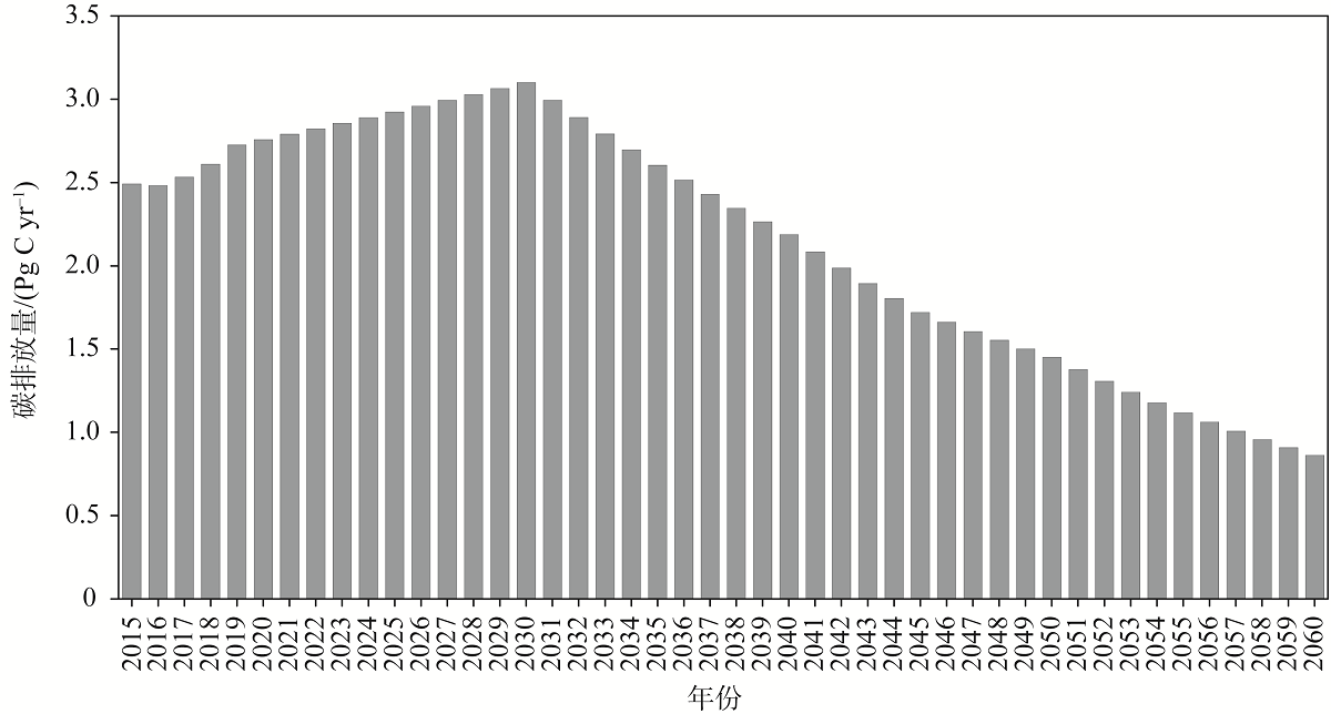
This study explores the possibility of carbon neutralization in China before 2060, based on the predicated carbon emissions from human activities and the carbon sinks produced by the territory ecosystem. The results show that the total anthropogenic carbon emissions in China is 0.86 Pg C yr -1 in 2060, and the ecosystem would neutralize 33% and 38% of the anthropogenic CO2 emissions in 2060 under the scenarios of IPCC RCP 2.6 and RCP 6.0. In 2060, woodland, grassland and cultivated land will be the main contributors of carbon sink, accounting for 93% of the total carbon sink. Compared with the year 2030, the contribution of carbon sink from woodland and grassland will decrease by 10% and 8%, respectively under RCP 2.6 scenario, while the contribution from cultivated land will increase by 18%; the contribution of carbon sink from woodland and grassland will decrease by 7% and 2%, respectively under RCP 6.0 scenario, while the contribution from cultivated land will increase by 4%. However, based on the highest carbon sink (2055) during 2051-2060, 65% and 82% of anthropogenic carbon emissions would be neutralized respectively. Therefore, to achieve carbon neutrality in 2060, the varieties of the bearing capacities of carbon budgets from different land use types should be fully considered in the territory planning.
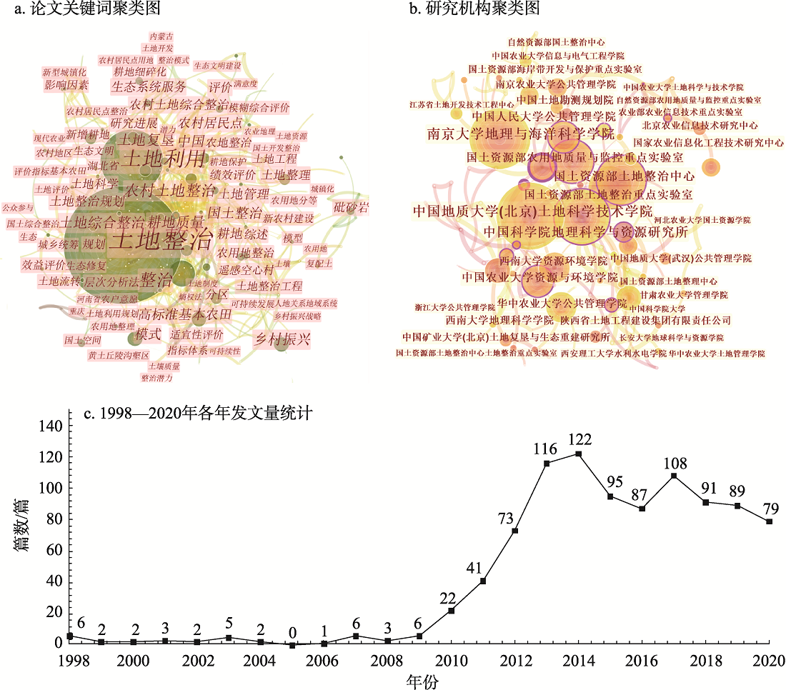
After nearly 40 years of development, China's territory consolidation has played an important role in promoting rural farmland protection, solving the problem of inefficient use of land resources, and helping poverty alleviation. This article reviews the development process of China's territory consolidation, summarizes relevant research progress based on bibliometric analysis and literature reviews, and puts forward key issues for future territory consolidation research. The following conclusions are drawn: China's territory consolidation undertakings and research have gone through three stages including territory consolidation planning, special territory consolidation projects, and comprehensive territory consolidation. The promotion of rural revitalization is the most important historical task of current territory consolidation. At present, territory consolidation research has formed a distinctive research system with the goal of solving the problem of land space and resource utilization and guided by policy management needs. Land use research is the theoretical support of territory consolidation, with agricultural land consolidation, rural settlement consolidation, comprehensive land consolidation and land-space ecological restoration as the main objects. Territory consolidation research formed a decentralized group consisting of management departments and characteristic scientific research institutes as the core research bodies. The territory consolidation research under the rural revitalization goal focuses on land consolidation planning, project site selection, consolidation zoning decision-making, land consolidation project full-process monitoring and supervision and performance evaluation, rural settlement consolidation potential evaluation, land consolidation policy effectiveness evaluation and other management needs. Besides, much research has been carried out on scientific issues such as the mechanism of land consolidation driving ecosystem change, the optimal allocation method of land resources, and the coordination mechanism of land use conflicts, giving full play to the characteristics of geography for theory serving practice. To accelerate comprehensive land consolidation in the future, we should focus on solving key issues around "theoretical framework-problem identification-planning and decision-technical system", and use theoretical research to promote the development of China's territory consolidation, and contribute to the realization of rural revitalization.
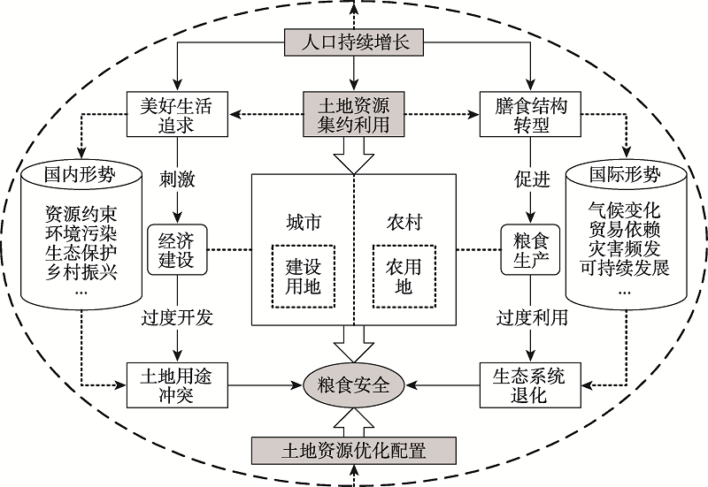
The optimal allocation of land resources is an important means to improve land use efficiency, alleviate land use conflicts, and promote harmonious man-land development. Current research on the optimal allocation of land resources in China has made great progress in theoretical exploration and practical applications. However, in the face of rapid land use changes, inefficient land management, and ecosystem degradation, the traditional optimal allocation way based on "quantity-spatial coupling" has been unable to meet the current needs in pursuit of a better life and sustainable development goals. Meanwhile, global food security is facing a series of severe challenges. The optimal allocation of land resources will directly affect and act on the coordination process between food production and economic development conflicts. Since the reform and opening up in the late 1970s, to serve the national strategic needs and key areas development (Yangtze River Delta and coastal areas), Nanjing University has carried out much research and practice around land resources optimization, so as to achieve the goal of ensuring resource security and food security. Researchers have focused on farmland pattern optimization, farmland intensification transition, farmland protection and planning, land use and urban-rural planning, land consolidation and agricultural land management, land use system innovation, land economic policy optimization and other characteristic research fields. Research directions take advantages of interdisciplinary deveoplment of geography and management, and have made contributions to disciplinary development and institutional innovations in the optimization and sustainable use of national land resources. In brief, this paper summarizes the key issues on China's land resource allocation by systematically combing the research progress related to the optimization allocation of land resources. Furthermore, on the basis of reviewing the academic contributions of Nanjing University, the opportunities and challenges faced by the optimal allocation of land and resources in China from the perspective of food security are summarized. The research can provide references for sustainable land use optimization.
In response to the changing globalization process and its uncertainty, we should get a better understanding of China's exchanges of natural resources with the world, which lays the foundation of national resource security and promotes sustainable development. The international division of labor has experienced development from inter-industrial trade, intra-industrial trade, to global value chains. These phases offer quite different insights into the natural resource flows of China. Recent advances primarily focus on the direct exchanges of natural resources between nations as well as the indirect flows of resources embodied in trading goods. The literature demonstrates four mismatches of China's natural resource flows: the mismatch between steady ramping demand and highly concentrated supply, between high intensity and low efficiency of resource utilization, between endowment differences and flow directions of resources, and between global improvement and local deterioration. Future efforts should be made to extend the theoretical perspective and respond to the rising uncertainties. Regarding the extension of theoretical perspectives, the introduction of global production network theory provides a holistic framework to investigate how firm linkages shape the routes of resource flows. Such an investigation represents the changing strategy of China's globalization from bringing-in to going-global. It can also contribute to the emerging research agenda of natural resource governance in China. In response to the rising uncertainties of globalization, we should deepen the understanding of the resilience of the network of natural resource flows and the dual circulation development pattern of natural resources.
It is of great significance in the implementation of rural revitalization strategy and the realization of its multiple goals to scientifically evaluate the level of the sustainable development ability and determine targeted development types of villages and towns. Based on sorting out the implication of the sustainable development ability implication of villages and towns from the perspectives of potential, support and resilience, this study establishes the evaluation framework and evaluation models. Meanwhile the study takes 25 towns in Jiangjin district of Chongqing as research units to quantitatively measure the sustainable development ability of villages and towns in 2017. And then it reveals the spatio-temporal differentiation and accordingly identifies the vulnerabilities types, and proposes targeted regulation strategies. The results shows that: (1) The sustainable development ability of villages and towns is the result of the interaction of potential, support and resilience. (2) On the whole, the potential of villages and towns shows a spatial pattern of " high in the north and low in the south" in Jiangjin; the support of villages and towns shows a spatial pattern of "high in the north and low in the south" in Jiangjin; the resilience of villages and towns shows a spatial pattern of "high in the south and low in the north" in Jiangjin; the sustainable development ability of villages and towns shows a spatial pattern of "high in the southwest, low in the northeast, cluster distribution". (3) We divide the sustainable development ability of villages and towns in Jiangjin into four types, including potential enhancement type, urban-rural integration promotion type, ecological security improvement type and potential-support-resilience ability comprehensive development type. Based on the principle of "ecological priority-classified control-highlight emphasis-local adaptation", the study proposes differentiated sustainable development ability improvement strategies for different types, to guide the sustainable development of villages and towns.
Based on China's provincial panel data from 2003 to 2018, this paper examines the spatio-temporal evolution characteristics of the coupling and coordinated development of rural land transfer and different types of farmers' income by building a coupling coordinated development model, and analyzes the spatial effects of rural land transfer on different types of farmers' income by using spatial Durbin model. Results show that: (1) From the perspective of time, the degree of coupling and coordinated development between rural land transfer and farmers' income tends to be optimized, but rural land transfer has always lagged behind agricultural income, and rural land transfer has changed from synchronous to ahead of non-agricultural income. (2) From the spatial dimension, the degree of coupling and coordinated development between rural land transfer and types of farmers' income varies significantly among different provinces. (3) Rural land transfer shows a direct effect on agricultural income and non-agricultural income within spatial units, and has a direct spillover effect on the per capita income of farmers. Although the increase in the scale of farmland did not obviously raise the non-agricultural income, agricultural incomes have been significantly improved owing to the scale economy.
Paying attention to the impact of land renting-out on the households' poverty vulnerability is of great significance for the long-term poverty alleviation of farmers and the formulation of rural anti-poverty policies. Based on the reasonable selection of control variables and the measurement of households' poverty vulnerability, this article employs DID, OLS and PSM-DID models to analyze the influence and regional differences of land renting-out on households' poverty vulnerability using the two-panel data of CFPS (2014 and 2018). The results reveal that: (1) The land renting-out behavior can significantly reduce the poverty vulnerability of households, which is considered as an effective means of poverty alleviation and plays a positive role in helping some households to resist income risks. (2) Variables such as gender, age and education level of households' head, labor force, health status of family members, net assets of family housing, cash and deposits, and local economic development levels also have a different impact on households' poverty vulnerability. (3) Further research shows that the larger the land renting-out rate of cultivated land is, the more beneficial it is to reduce the households' poverty vulnerability, but this result has not passed the significance test, and the interpretation of this research conclusion still needs further research. (4) In addition, the impact of land renting-out on the households' poverty vulnerability shows a certain regional difference. Among them, it has played a significant role in reducing the poverty vulnerability of farmers in the eastern, central and northeast regions, but it is not obvious in the western region. In order to ensure the robustness of the research conclusions, the estimation results are tested by various matching methods, and show that the conclusions in this paper are stable and reliable. It is suggested that in the future, under the premise of respecting the wishes of farmers, the farmland transfer market should be further improved, and differentiated guidance policies should be provided according to the actual needs of households. At the same time, the support of the family education, finance, and social security should be increased for the land renting-out family, thereby promoting the sustainable development of their livelihoods.
Based on the theoretical foundations underpinning the Department for International Development's sustainable livelihood framework, this paper constructed an influence mechanism of rural land consolidation projects (RLCP) on farmers' income, and further conducted the heterogeneous analysis of its consolidation modes and geomorphic types. Based on the survey data collected from 483 farmers of Tianmen city and Qianjiang city in Jianghan Plain area, Xuan'en and Xianfeng counties in Wuling Mountainous Area, difference-in-differences (DID) model was employed to examine whether the implementation of land consolidation affects farmers' income, the impact of different RLCP modes of the same geomorphic type on farmers' income, and the impact of the same RLCP mode of different geomorphic types on farmers' income. The results indicate that: (1) Both the local government-dominant mode and new agricultural business entity-dominant mode RLCP can significantly increase farmers' income. (2) The income-increasing effect of the new agricultural business entity dominant RLCP is far greater than that of the local government-dominant mode RLCP, and even if in the same geomorphic types, there are significant differences in the degree, direction, and significance of the impact of different RLCP modes on farmers' income. (3) The income-increasing effect of plain RLCP is evidently higher than that of the mountain RLCP, but even if in the same consolidation mode, there are significant differences in the degree, direction, and significance of the impact of different geomorphic RLCP types on farmers' income. Therefore, the income effect of RLCP is affected by the consolidation modes and geomorphic types.
In this paper, we focused on a new land-use model of integrated rice-aquatic coculture systems and based on the survey data in Qianjiang and Jingzhou, calculated and compared the ecological-economic effects of rice-crayfish co-culture and rice monoculture. The results show that compared with rice monoculture, rice-crayfish co-culture can improve the ecological-economic effects of land use. However, more than half of the co-farming households in the surveyed area continue the traditional extensive production mode, and there is a serious excessive investment in production, which hinders the further optimization of the ecological-economic effects of their land use. In addition, if we only consider the economic effects but ignore possible negative effects on environment, the land-use efficiency of rice-crayfish co-culture will be overestimated by 45.28%. At present, it is urgent to incorporate environmental impact into land-use efficiency assessment, implement the development concept of "double water and double green", guide farmers to rationally arrange various production inputs, and effectively optimize the ecological-economic effect of rice-crayfish co-culture, so as to promote sustainable land use.
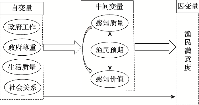
Fishermen are the core role of the ecological compensation policy for the fishing ban in the Yangtze River, so their satisfaction is related to the performance of the ecological compensation policy introduces with the fishing ban. Chishui River and Honghu, which were the first places in China to implement the policy, were selected as the research areas. Based on survey data from fishermen who have withdrawn from fishing, the TOPSIS which improved by entropy weights combined with the obstacle degree model was employed to evaluate the policy performance and to diagnose its influence factors. The results indicate that: (1) The values of positive and ideal solutions of fishermen's evaluation for the policy in Chishui River and Honghu is 0.45, 0.27 respectively, indicating the performance in the poor level; (2) The top three main factors are the social activities , social status , and living standards of the family, which may related to the satisfaction with government work after the fishing ban, This study provides an alternative analysis framework for the assetment of the performance of the fishing ban's ecological compensation policy, and provides a reference for other regions to improve the performance of policy.
Based on the five lists of traditional villages published by the Ministry of Housing and Urban-Rural Development (China) and the poverty-stricken villages in poverty alleviation for a whole village during the 12th Five-Year Plan period (2011-2015), this paper analyzes the distribution pattern and spatial correlation of Chinese traditional villages and poverty-stricken villages, and discusses the relationship between the spatial correlation and regional natural environment and socio-economic factors. The results show that: (1) In terms of the spatial distribution relationship between traditional villages and poor villages, the regions with high-density traditional villages and high-density poor villages are mainly distributed in provincial-level regions of Hubei, Hunan, Guizhou, the border of Guangxi, the north of Shanxi, which are mostly contiguous poverty-stricken mountainous areas. Regions with low-density traditional villages and low-density poor villages (low-low type) are generally located in coastal and border areas, while low-high type areas are generally located in provincial border areas; the villages of high-low type are mainly distributed in Zhejiang and Fujian provinces with high economic development level. (2) Taking the low-low type regions as the reference, the low-high type areas are significantly negatively correlated with transport accessibility and regional economic development, and positively correlated with population, temperature, elevation and slope, which indicates that the risk of poverty is higher in areas with larger population and worse natural conditions (higher temperature, gradient and elevation). (3) Compared with low-low type areas, high-low type areas have a significant positive correlation with urbanization rate, which indicates that areas with higher density of traditional villages tend to have higher urbanization rate, and the urbanization process has no serious impact on the protection of traditional villages. There is a significant negative correlation between transport accessibility, population and high-high type areas. (4) The influence of different slope, temperature and precipitation areas on the spatial correlation of traditional villages and poor villages is different. It is necessary to make strategies for poverty alleviation and development of traditional villages according to local conditions. This paper aims to provide some guidance and support for China's poverty alleviation and rural revitalization based on the protection and development of traditional villages.
The collaborative transformation of rural production factors, namely the coordination among flow of labor, farmland transfer and capital circulation, is crucial for rural development. This paper constructs a theoretical framework of the collaborative transformation among the three factors and the impacts of some local influencing factors. With the case of Yueyang city, Hunan province, we reveal the transformation levels of each production factor, explore the spatio-temporal patterns of collaborative transformation, and examine the endogenous and exogenous influencing factors underlying the spatial heterogeneity of the collaborative transformation levels. Based on the theoretical hypothesis that transformation of the three factors will be upgraded from "mismatch" to "collaboration", empirical findings are as follows: the transformation level of labor is much higher than that of farmland and capital; the spatial patterns of the levels are different; the collaborative level of factor transformation is not high, but a trend of temporal uplifting and spatial aggregation is apparently shown; slope, cultivated land resource endowment, distance from the county seat and government investment in rural and agricultural development are the key endogenous and exogenous factors respectively. Distance from the county seat has positive effect, while other factors have both positive and negative effects. Policy implications are proposed according to the collaborative levels and local conditions.
Under China's goal of achieving high-quality development and reaching the peak of carbon emissions before 2030, it has become a hot topic of academic research to find a low-carbon way to ensure economic growth. Based on the panel data of provinces and regions in China from 2005 to 2017, this paper studied the impact of multi-dimensional characteristics and evolution of industrial structure on carbon emissions at the provincial scale by establishing SAR model and PECM with eight economic regions as the study area. The main conclusions are as follows: (1) Regional carbon emissions have significant time delay and spatial spillover effect. (2) From the national perspective, the improvement of industrial structure rationalization level can effectively inhibit carbon emissions, and has negative spatial spillover effect. However, the elevation of industrial structure supererogation level can effectively promote carbon emissions, and has positive spatial spillover effect, which is generally reflected on the left side of the "inverted-U" curve. (3) From the perspective of the eight economic regions, with the development of economy, the evolution of the industrial structure rationalization level can inhibit carbon emissions on the whole, while the evolution of the industrial structure supererogation level showed a trend of obvious "inverted U" features, which has two sides, with the inhibition effect in developed regions and the opposite in underdeveloped regions. The regions in the declining area of the "inverted-U" curve are mostly developed regions. The increasing carbon emissions caused by the elevation of industrial structure supererogation level is still an inherent periodic characteristic of the current development in most Chinese provinces and regions. However, improving the level of industrial structure rationalization will generally push ahead with the peak of carbon emissions and accelerate the process to reach the peak of carbon emissions. This paper argues that the underdeveloped regions should not aim at increasing the share of tertiary industry and blindly elevating industrial structure supererogation level, which is likely to have a negative impact on the economy and the environment. The improvement of industrial structure rationalization level is an effective way to adapt to the current development inertia of most provinces and regions in China, and to curb carbon emissions and reduce the growth of it.
Ecotourism is an important way to realize sustainable development of tourism, and ecotourism level measurement is the basic work of ecotourism research. In this paper an ecological level analysis framework and measurement model of tourist destination based on the theory of energy value are constructed innovatively. Taking Wuling Mountain Area as the research object and based on relevant sectional data of the research area in 2018, the county administrative unit was taken as the research unit to measure the ecotourism level. The result shows that the ecotourism level in the study area is below the average level. The number of tiered county units is distributed in the shape of a pyramid. There are significant differences in the target level indicators of the evaluation system. The exploratory spatial data analysis method shows that the spatial distribution of tourism ecological level in the study area shows obvious clustering characteristics, strong positive correlation and weak heterogeneity. The spatial distribution of sub-indexes shows that most county units have not achieved coordinated development of the regional tourism and environmental protection.
While promoting the regional social and economic development, the tourism in arid areas aggravates the contradiction between the supply and demand of water resources. In view of the characteristics of water resource endowment and tourism industry in arid regions of China, this paper puts forward an evaluation model of water supply and demand suitability of tourism industry in arid regions. According to the contribution rate of tourism output to gross domestic product, the proportion of tourism employees in employment, and the constraint of regional water resource endowment, a comprehensive calculation model for the water supply of tourism in arid areas is built; from the perspective of tourism all-elements, a tourism water demand measurement model is established, which is composed of catering, accommodation, energy, visiting, and shopping water accounts, etc.; aiming to set up the quantitative relationship between "supply" and "demand" water quantity, a combinatorial analysis method was used to construct an index evaluation model for the suitability degree of water supply and demand for tourism industry, and an evaluation threshold was set to evaluate the suitability degree of water supply and demand for tourism industry in arid areas. The empirical prediction of the degree of water supply and demand suitability for tourism in Xinjiang in 2025 is made, and the following conclusions are drawn: the maximum development rate of tourism in Xinjiang should be within 15%; at the same time, the Xinjiang government should keep the average annual water-saving rate of social water consumption at or above 0.95%; in the event of an emergency, the development rate of tourism in Xinjiang in subsequent years can be increased to 20%. Only in this way can the tourism industry maintain the state of "basic balance between supply and demand" or even better.
Under the background of global change, the ecosystem of the Qinghai-Tibet Plateau has been affected and threatened by both nature and human activities, and the ecological risks are intensifying. The Qinghai-Tibet Plateau is a relatively independent geographic unit with a high average altitude and complex and diverse landforms. Its fragile alpine ecosystem is extremely sensitive to global climate change. In recent years, the population of the plateau has increased and the process of urbanization has accelerated, the scale and intensity of human activities have increased significantly, and ecological risks have increased. At present, the research results of ecological risk assessment are mainly found in local areas of the Qinghai-Tibet Plateau. This article, aiming at understanding the source of ecological risks, analyzes the spatial distribution of risks and their causes. The ecological risk assessment of the entire plateau is expected to provide references for the identification, management and early warning of regional ecological risks. We establish an ecological risk assessment index system for the study area, which includes 13 ecological risk source indicators, 10 ecological vulnerability indicators, and 7 ecological risk management capability indicators. Then we select the official remote sensing product data with a high spatial resolution, according to the characteristics of the data which are divided into numerical and non-numerical data. Using ArcGIS 10.2 to normalize the numerical data, according to the contribution rate to ecological risk, the non-numerical data are graded, and the ecological risk evaluation optimization model is used to comprehensively evaluate the ecological risk of the plateau. The results showed that: overall ecological risk of the study area is relatively low, with low and very low ecological risk areas accounting for 55.84%, extremely high risk areas being only 7.19%, high risk areas 11.95%, and medium ecological risk areas 25.02%, and the extremely low and low ecological risk areas account for more than half of the plateau area; medium ecological risk areas are mainly distributed in areas with high intensity of human activities. The impact of human activities on the eco-environment of the Qinghai-Tibet Plateau cannot be ignored; the extremely high-risk areas and medium-risk areas form a "C"-shaped pattern; the low-risk areas in the hinterland of the plateau have higher altitudes, severe cold climates, and fragile eco-environments, but the strengthening of ecological management measures has greatly reduced the ecological risk in the study area. The overall ecological risk of the Qinghai-Tibet Plateau is mainly controlled by natural factors, and the impact of human activities on the eco-environment cannot be ignored. The establishment of national nature reserves or national parks to protect the ecological environment can greatly reduce its ecological risks. It is necessary to pay special attention to areas with high intensity of human activities on the plateau, where their ecological risks have reached a medium intensity. Creating a new pattern of harmonious coexistence between humans and nature, and avoiding excessive human intervention in the eco-environment on the Qinghai-Tibet Plateau is an important way to reduce ecological risks in the future.
Green finance, which aims to regulate social capital flows, optimize the industrial structure, and realize green growth, has been a promising area of financial innovation. Since 2015, both the Chinese central and local governments have issued various policy incentives to benefit green finance. As a result, many cities in China have introduced and practiced green finance, which led to a boom. Previous research focuses on the concept and development of green finance, enterprises' and financial institutions' performance, but largely neglecting its regional disparity and influencing factors. This paper takes green bonds issued from 2016 to 2019 in 142 Chinese prefecture-level cities as a case. Based on the panel data model and spatial Durbin model, we explore the influence of policy incentives, financial development, and environmental pollution on the green bond issuance scale in different regions. Meanwhile, the interaction between variables has been explored to reveal the regional heterogeneity of green finance development. The results reveal that green bonds are mainly distributed in cities with a robust financial basement and a high administrative level. Although quite a few cities in the central and western regions started to issue green bonds after 2015, the growth of green bonds mainly took place in the eastern region. Policy incentives and financial development have significantly promoted the growth of green bonds, while environmental pollution has impeded the issuance. Policy incentives provide a low-risk context and stimulate the local financial sectors to innovate in green finance across China. However, the obstacle brought by environmental pollution can only be alleviated by the policy in the eastern region. Environmental pollution, generally caused by polluting industries, is a challenge for the central and western regions to develop green finance. With applicable policy incentives and robust financial industries, the eastern region can easily follow the green economic transformation trend and realize green finance innovation. For the central and western regions, the conflict between economic and environmental goals impeded the development of green finance. This paper suggests that more attention should be paid to regions with weak financial foundations and severe pollution. A regional cooperation platform should be established to improve the inclusion of green finance.
The numbers of 35, 34 and 106 of soil samples in the economic belt of the Yangtze River in Anhui were collected at A, B and C sampling sites by the grid points of 2.5 km× 2.5 km, respectively, the Cd content was measured by ICP-AES, and single factor pollution index, geoaccumulation index and potential ecological risk index were selected to assess the environmental risk of Cd at the three sites. The results showed that: (1) The average values of Cd content were 0.40, 0.66 and 0.84 mg?kg -1 in soils of A, B and C sites, respectively, which were higher than the background values of Cd content in the soils of Yangtze-Huaihe river basin of Anhui. (2) The pH values of soils at the three sites were 5.06-7.58, which was between acidic and weakly alkaline. The number of samples with pH less than 7.0 was 167, accounting for 95.43% of the total number. (3) The low pollution area is distributed as a ribbon in space, while the high pollution area is distributed as an island in space of the three sites; different soil types have different pollution characteristics of Cd. (4) The assessment results were identical and presented as follows: site C > site B > site A by the single factor pollution index, the geoaccumulation index and the potential ecological risk index. In conclusion, we should focus on the safe utilization of soils and give targeted guidance to the study regions.