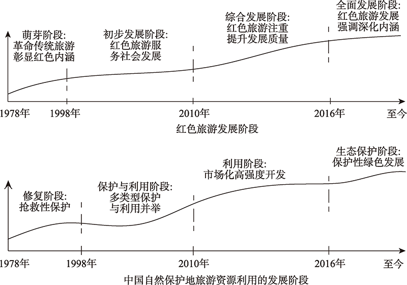
Starting from red tourism resources, which are distributed linearly across administrative regions and are mostly accompanied by natural resources, this paper discusses the problems such as the mismatch between regional red tourism and territorial space planning, and the interweaving of red tourism and three control lines. Therefore, from the perspective of the hierarchical conduction and conflict and coordination in planning, in order to solve the problems of regional incongruity and land use control of red tourism, hierarchical and conducted spatial system of red tourism is constructed by means of vertical and horizontal conduction. Specifically, when red tourism conflicts with the red line of ecological protection and the red line of permanent basic farmland, we should emphasize ecological conservation in tourism development, and focus on protection of the red cultural resources within the scope of urban development. This paper not only explores a high-quality development path for red tourism under the control of the planning system, but also improves the scientificity and operability of the delimitation of the three control lines of the planning system.
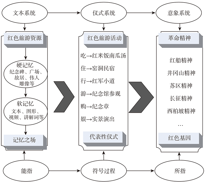
Red tourism plays an important role in transmitting red memory, but there is a lack of in-depth theoretical discussion on the basic questions of why red tourism can transmit red memory and the specific process of transmitting red memory by red tourism. With the help of cultural memory theory and interactive ritual chain theory, this study attempts to conduct an in-depth theoretical discussion on the mechanism of action and dynamic process of red memory inherited by red tourism, in order to contribute to the basic theoretical framework of red tourism. In the specific theoretical analysis, this study firstly argues the cultural memory attribute of red memory, and then uses the cultural memory theory to analyze the basic laws of red memory transmission. On this basis, combined with the special characteristics of red memory, it clarifies the important role of ritual system in transmitting, evoking and consolidating red memory. Secondly, by analyzing the rationality of red tourism activities as a kind of ritual, this study puts forward the theoretical logic of red tourism activities in transmitting red memories, and proves the theoretical "legitimacy" of red tourism as a means of transmitting red memories. Again, considering the interactive nature of red tourism activities, this study puts forward the dynamic process model of red tourism activities in transmitting, evoking and consolidating red memories on the basis of the theory of interactive ritual chain. This model theoretically explains the specific process of red tourism activities as rituals to transmit, evoke and consolidate red memories. From the research results, cultural memory theory and interactive ritual chain theory, provide a broad theoretical exploration and rich theoretical details for the study of the relationship between red tourism and red memory, and through the application of these two theories, we have a bettter understanding of the inner logic and specific process of red tourism in transmitting red memory from a more general perspective and at a deeper level. However, it must be acknowledged that the above theoretical logic and process models are based on theoretical derivations and still lack the necessary empirical research evidence, so future research will focus on validating and revising them through empirical studies and case studies. The findings of the article help red tourism theoretical researchers understand the relationship between red tourism and red memory from a more universal perspective and at a deeper theoretical level, and provide basic theoretical support for better red tourism work in the practical field.
Red tourism, as an important way to inherit revolutionary culture, can promote the patriotism education publicly and improve the economic development of old revolutionary areas. This paper studies the spatial distribution and heterogeneity of influencing factors of 763 scenic spots in 300 published red tourism classic attractions of China, by constructing a theoretical framework system, spatial analysis methods and regression models, so as to put forward the development mode and countermeasures. The results show that: (1) The spatial distribution of classic red tourism scenic spots is affected by four subsystems: resources, environment, society and economy. (2) In terms of spatial distribution, the core areas are more dispersed compared with other tourist attractions, which presents a pattern of seven first-class core areas, seven second-class core areas, two contiguous second-class core areas, low-density, lower-density areas and so on. The spatial correlations are quite different, and the correlation effect weakens with the reduction of spatial scale. (3) The influencing factors of classic red tourism scenic spots are different in different regions. The influence degree is red tourism resources > altitude > policy intensity > slope > transportation facilities > market demand > resource linkage > consumption level. (4) In the future, the construction of classic red tourism scenic spots should focus on the development mode and countermeasures of network, node, corridor, symbiosis linkage and cross-regional coordination. The conclusions can provide scientific decision-making basis for the red tourism development, management and cross-regional cooperation.
The development efficiency of red tourism represents the high-quality development level of red tourism. Taking the red tourism region in Northern and Western Guizhou province as the research object, we used DEA model and Malmquist index to measure the red tourism development efficiency of 17 counties in the study area from 2014 to 2019, and applied the kernel density function and multiple linear regression model to analyze the characteristics of its spatial evolution and key influencing factors. The research found that: (1) The overall efficiency of red tourism development in the study area is low. Thanks to the technological progress, the development efficiency of red tourism in most of the counties (cities, districts) is steadily improving. (2) The spatial distribution of red tourism development efficiency has the characteristics of agglomeration and heterogeneity, showing an "M" bimodal pattern as a whole, and the distribution of red tourism development efficiency varies greatly among counties (districts and cities). (3) Technological innovation, the advantage of red tourism resources, and the convenience of transportation are the main factors that affect the development efficiency of red tourism in the region. The economic intervention from the government to the tourism, the level of economic development, and the scale of talents have little impact on the efficiency of red tourism development in the region. The positive impact of structure on improving the efficiency of red tourism development in the region has not yet been highlighted.
This paper compares the goals and implementation effects of the red tourism policy, thus helping public policy makers to allocate and optimize tourism resources. Meanwhile, it is of great significance to help market participants to adjust the development and innovation of red tourism products. Specifically, we firstly integrate government service texts and Sina Weibo texts with the theme of "red tourism" as well as relevant statistical data to form a panel dataset of 31 provincial-level regions in China from 2011 to 2019. Then, the text semantic analysis is carried out to identify policy gap. Furthermore, the spatial weight matrices are built from the perspective of policy spatial relevance. Finally, the spatial panel Durbin model is constructed to estimate the spatial spillover effect of red tourism policy on online attention from the perspective of policy spatial correlation. The findings are as follows. (1) The policy gap exists in the development of red tourism to some extent. (2) The public online attention to the red tourism is significantly dependent on geographic and policy space. The main reason for its spillover effect is that government services attach great importance to the goal of spreading the red culture, but the stability of the policy is negatively correlated with the online attention. The unstable competition and cooperation relationship among governments and the low-level steady state of the policy development environment are possible reasons that cause the public to pay less attention to red tourism than expected. (3) Under the effect of geographical and policy spatial correlation, the regional public service capacity presents a positive spillover effect, while the information variables show a negative spillover effect. Strengthening regional cooperation and integration of information service and other elements is the direction of red tourism policy innovation.
With the development of the economy and the improvement of living standards, the tourism market is rising fast. However, entertaining in a limited tourist area, the huge number of tourists causes many problems, such as traffic jams, conflict in using of facilities, and resource destruction. Poor tourism management leads to frequent accidents and causes a great loss of people's lives and property. Since the tourist areas where tourists are active have boundaries, the carrying capacity is often limited in a certain period. The carrying capacity of the scenic area is an important field of tourism research. A lot of achievements have been made in domestic and international research. However, the existing scenic area carrying capacity estimation model is based on a traditional method that does not involve the dynamics of tourists entering the scenic site. Since tourists cannot fill the whole scenic area instantaneously, this research proposes a concept of dynamic carrying capacity. Firstly, the paper studies the conceptual model of the dynamic carrying capacity of the tourist area. It presents the elements such as the stay area, the passage, the entrance and exit, and obtains the relevant carrying capacity through the local carrying capacity calculation model. Then, based on the network structure model, logical structures of the residence area, passage and entrance and exit elements in the dynamic carrying capacity model are designed, and the detailed object relation diagram of nodes and passage edges is presented. Finally, the estimation method of the dynamic bearing capacity of the tourist area is given. Nanjing Precedential Palace is selected as the experimental area to verify the proposed method. The application of GIS technology in scenic environments can not only realize the spatial pattern analysis of scenic tourism activities and dynamic monitoring of the impact intensity of tourism activities but also help determine the quantitative level of tourist area bearing capacity and improve the quantitative level of the effectiveness of time-sharing management measures. Consequently, it promotes tourist attractions to achieve higher quality economic and social benefits under a safer production.
The water resource ecological footprint model was used to study the water resource ecological footprint and ecological carrying capacity of 131 cities in the Yangtze River Economic Belt from 2010 to 2018. The spatial and temporal characteristics of urban water resources in the study area are revealed and discussed by GIS visualization and spatial autocorrelation. The results show that: (1) The Hu Huanyong Line (also known as Heihe-Tengchong Line, or Hu Line) hypothesis is valid in the Yangtze River Economic Belt. (2) The region west of the Hu Line tends to have higher per capita water resource ecological surplus. Per capita water resource ecological surplus of the region between Hu Line and Hu Sub-line is higher than that of the region west of the line. (3) The per capita water resources carrying capacity and the average water resources carrying capacity of the regions west of Hu Line in the study belt are the largest of the three regions. (4) The ecological footprint of ten thousand yuan GDP of each city is decreasing, which means that the utilization rate of water resources is increasing. (5) The average load index of water resources has been increasing year by year. The results are helpful to the integrated management of water resources and provide a quantitative basis for the regulation and use of water resources in the Yangtze River Economic Belt.
Mineral resources bases are the strategic core area to optimize the layout of mineral resources exploration and development in China and ensure resources security. Based on the analysis of the influencing factors of mineral resources bases layout, this study formulated an index system to delimitate the mineral resources bases from the following four aspects: resource endowment, development conditions, market demand and national strategy. The resource endowment includes three indexes, namely, forecast resources, identified resources and development & utilization status quo; the development conditions include water shortage degree and transportation superiority; the market demand includes both the layout and output values of subsequent smelting and processing enterprises; the national strategy can be mainly reflected by the requirements of regional coordinated development strategy for the layout of mineral resources bases. On this basis, taking iron ore as an example, this paper carried out an empirical study on the delimitation of mineral resources bases to test the rationality of the index system. After evaluation of the resource endowment indexes by cluster analysis and kernel density estimation, and analysis of all the other indexes, twelve iron ore resources bases were identified through comprehensive judgment, including Anshan-Benxi of Liaoning, Eastern Hebei, Panzhihua-Xichang of Sichuan, Xinzhou-Luliang of Shanxi, Central-Western Shandong, Baotou of Inner Mongolia, Huoqiu and Ningwu-Luzong of Anhui, Southwest Hubei, Lancang of Yunnan, Tianshan and Western Kunlun of Xinjiang. The results provide some references for the adjustment and optimization of China's mineral resources bases for the "14th Five-year Plan", and might be significative to the delimitation of other mineral resources spatial policy areas.
This paper explored the evolution of urban-rural spatial structure in China and its influencing factors since 1985 by using the urban-rural construction land and socio-economic data, and took Huaibei, a typical coal resource-based city, as a study case. The results showed that: (1) Generally, the urban-rural spatial structure in coal resource-based city develops in three stages. Firstly, the city mainly depended on the coal industry, and formed the "urban-mining-rural" ternary structure in 1985-2000. Secondly, the urban-rural spatial structure has evolved into a "center-peripheral" structure. In addition, the centrality of the major urban area is gradually highlighted. Thirdly, the urban-rural spatial structure evolved into a circle structure in 2010-present. Moreover, the speed of city transformation and development has accelerated. And the main urban area spread to the suburbs. (2) In essence, the evolution of urban-rural spatial structure was a process from dispersion to aggregation, and from separation to integration. (3) Management system of mining city, urban-rural industrial structure, municipal transportation network and policy system interacted to promote the evolution of urban-rural spatial structure in coal resource-based cities.
Scientific exploration of the decoupling relationship between land use intensity (LUI) and ecosystem services intensity (ESI) can effectively reveal the disturbance of land use change to ecosystem and provide a solid basis for land use policy making and ecosystem protection in China. However, previous studies lacked specific research on the decoupling degree between LUI and ESI at county scale. To fill these gaps, this study measured the spatiotemporal distribution pattern of LUI and ESI with methods of ecosystem services intensity and land use intensity based on the remote sensing monitoring data of land use status and the Normalized Difference Vegetation Index in China from 2000 to 2015. The decoupling relationships between them were explored with the help of the decoupling theory analysis framework. The results showed that: (1) There was significant spatial heterogeneity in the ESI in China during the study period, and the ESI in Southeast China was significantly higher than that in Northwest China. The ESI in the plain areas, urban agglomeration areas, and the surrounding areas of large cities were significantly lower than those in the hilly areas. (2) LUI in China continued to increase during the study period. LUI in Southeast China was significantly higher than that in Northwest China. LUI in Southeast China exhibited the features of low-value LUI units distributed among high-value LUI units, while LUI in Northwest China exhibited the features of high-value LUI units distributed among low-value LUI units. (3) The results of decoupling analysis showed that strong decoupling and expansion negative decoupling were the main relationship types between LUI and ESI in China. The former was a dilemma mode, and the latter was a win-win mode. The study found that the interference of LUI on ESI varied greatly in different stages of land use. The results can provide scientific guidance for the policy making of land use and ecosystem management.
Analyzing the impact of economic agglomeration on land use eco-efficiency in urban agglomerations is helpful in improving cities' competitiveness and the quality of environment. Using the Super-EBM of undesirable output, in this article we measured the land use eco-efficiency of the three major urban agglomerations of China, namely, the Beijing-Tianjin-Hebei Region, the Yangtze River Delta and the Pearl River Delta, from 2005 to 2016. Then it analyzed the spatio-temporal evolutionary characteristics of land use eco-efficiency by using Kernel density function. Finally, panel threshold regression model and panel vector auto regression model (PVAR) were established. We discussed the non-linear impact and linear direct impacts of economic agglomeration on the land use eco-efficiency in the urban agglomerations from the perspective of industry and population. The main results are as follows. (1) During 2005-2016, the land use eco-efficiency of the three major urban agglomerations showed an evolutionary characteristic of convergence and differentiation and each urban agglomeration had its own spatio-temporal evolutionary rules. (2) The tertiary industrial agglomeration level and population agglomeration level showed a single threshold effect on the land use eco-efficiency of the urban agglomerations. Therefore, moderate industrial agglomeration and population agglomeration have a positive promotion effect on the land use eco-efficiency of the urban agglomerations, otherwise, the promotion effect will decline or even have a negative impact. (3) The direct impact of the tertiary industry agglomeration level and land use eco-efficiency on the land use eco-efficiency reached the peak from the beginning and then converged to 0, while the secondary industry agglomeration level and population agglomeration level had negative impacts and then changed to be positive. When formulating policies concerning economic development and land use, the local governments must give full play to the positive impact of economic agglomeration on the environment. In addition, they should pay attention to the appropriateness and dynamics of different economic agglomerations.
Rural housing land transition is one of the most important aspects of land use transition, which has attracted interest among a wide variety of researchers as well as the government officials. To date, the majority of literatures in this field focuses mainly on the decline of rural housing land in respect of its share in the growth of total construction land with the development of local economy, while little attention has been paid to the change of its recessive morphology. Taking Southern Jiangsu, one of the most developed regions in China, as an example, this paper demystifies the general trajectory of the functional transformation of rural housing land through the lens of utilization status (i.e., normal, vacant, and abandoned). The results imply primarily that the issue of "housing is not for accommodation", which has been widely witnessed in urban China, has also been detected in rural areas of Southern Jiangsu. And a temporal and spatial heterogeneity of vacant and abandoned rural housing lands has been verified. Specifically, the transition of rural housing lands used before the 1980s tends to be more visible in the "both ends" near and far from the city with a relatively low share of vacant and abandoned lands to the total rural housing land in the central area. Within the double processes of urbanization and industrialization, the pattern of rural housing land transition during the last two decades of the 20th century shifts from the inverted-U trend to an inverted-S one, which is resulted from the distance attenuation of urban effects. With the functional transition of rural housing land from residence to property, the relationship between the utilization status of rural housing land and its location, particularly within the context of rural revitalization, has weakened in recent years. However, the share of vacant housing land has rebounded with a phenomenon of "housing land hoarding" being witnessed in rural areas since 2010, which predicts the sprawl of "real estate hegemony" originating in urban areas to rural areas.
In recent years, the ecologically-degraded areas, such as rocky desertification, have often been taken as one of the main pilot types of the fallow cultivated-land in China, where the conflicts between man and land are prominent and the village committees are responsible for the management and protection in fallow pilot. To explore the main problems arising in the different fallow management and protection modes with the new types of the business entities as the fallow management entity in ecologically degradation area and its applicable operating conditions, on the basis of the actor- network theory, taking Songtao county of the country's first batch of fallow pilot as a case study, with 5 districts (7 villages) selected as samples, this research focuses on the main problems arising in different fallow pilot stages, and analyzes the stability of the actor-network with the different fallow management and protection modes and the characteristics and its applicability of the different fallowing management modes. The findings can be summarized as follows: (1) Songtao county witnessed four types of fallow management and protection modes in different stages, that is, Mode I (management and protection by planting peasants), Mode II (management and protection by the cooperatives for some peasants), Mode III (management and protection by some companies or enterprises) and Mode IV (management and protection by the cooperatives of village collectivity). The translation process of the fallow actor-network went through two stages under different fallow management and protection modes, and nine problems arose during fallow period, thus leading to the instability of the actor-network during the trial stage and its divergences during the adjustment stage. It is found that "the substantial reduction in fallow subsidies and the current unified fallow subsidy standards" were the two main factors for the actor- network divergences. It is suggested that a set of flexible, step-by-step fallow subsidy standards should be established, the fund management during fallow period be reinforced, some investment and financing approaches be innovated, and the investment in machinery be promoted. (2) In the fallow actor-network, the rational behavior of human actors was the key to the smooth progress of the fallow pilot, the fallow management and protection modes as well as strategies should be adjusted to local conditions. Mode I is suitable for the dam areas with good agricultural basic conditions, but the existing subsidy standards needs to be raised as appropriate; Mode II suits any area, but needs to allocate fallow subsidies reasonably and raise the existing subsidy standards as appropriate. Some profitable crops such as peanuts can be grown under the premise of taking risk prevention measures; Mode III is more suitable for areas with severe rocky desertification, but the participation requires those companies or enterprises with strong financial foundation and related agricultural industries; Mode IV is more suitable for relatively remote and backward mountainous areas governed by the village officials with strong management capabilities, yet lack of fees for land circulation, on the condition that the basic requirements must be met in these fallow areas. (3) No matter which kind of fallow management and protection mode is adopted, the key to selecting appropriate fallow areas in the severely ecologically-degraded areas is to maintain a balance between improving land fertility and promoting farmers' income, meanwhile to strictly select fallow districts and control the fallow duration, to ensure the sustainable use of fallow cultivated land when it comes to cultivation period again and to make efforts to get the fallow farmers employed. In addition, it is advisable to make improvement in other related fallow actors, such as township governments, agricultural service centers, some committees in villages, and risk prevention systems, in order to further improve the stability of the fallow actor-network.
The delineation of urban development boundary is an important part of land spatial planning, and also a key to the implementation of land spatial governance, urban and rural development management, and ecological security management and control. It plays a fundamental and restrictive role in promoting the high-quality development of urban space. This article takes the central urban area of Nanjing as an example, and the logistic regression analysis model, InVEST model and CA model were used to explore and construct a method of urban development boundary delineation based on ecological constraints. According to the evaluation of the importance of urban ecological land and the spatial expansion potential of construction land, a simulation of urban land expansion in different target years was carried out to delineate urban development boundary. The results show that the expansion of urban construction land has dynamic, complex and systematic characteristics, and is subject to multi-factor interactions. The urban development boundary simulation based on ecological constraints can take into account the needs of urban space development and residents' high-quality ecological environment demands, promote the unification of urban development and ecological protection, the coordination of population economy and resources and the environment, and help enrich the delineation methods of urban development boundary research, which provide scientific reference for the preparation of land spatial planning.
From a bilateral perspective of land coupon reclamation and usage, this paper aims to analyze the spatio-temporal characteristics of land coupon trading and its coupling mechanism with urban-rural migration in Chongqing. Land coupon trading data and urban- rural migration data are analyzed with locational Gini index, hot spot analysis and gravity models. We found that: (1) The main urban areas of Chongqing are concentrated distribution area of gravity-center of land coupon usage, and also the place where hot spot areas are densely distributed. Land coupon usage in the main urban areas has experienced a process of increasing first and then decreasing. Spatial distribution of gravity-center of land coupon usages moved evidently northeastward. Land coupon usage in the western part of Chongqing has grown significantly. The northeast and northwest parts, which are the main output areas of land coupon, also have demand for the use of land coupon. (2) Northeastern and Northwestern Chongqing is the primary and secondary output areas of land coupon. There is an explosive output of land coupon in the western part during the study period. The equilibrium of land coupon usage and output showed a convergent trend of land coupon transaction. (3) We measured the overlapping of two centers of gravity and the consistency of their movement by model of the coupling mechanism, which illustrates that the spatio-temporal characteristics has a high correlation with the urban- rural migration. In general, the regions with high population urbanization level use more land coupon, and the regions with more urban-rural migration produce more land coupon. The differentiated landing policy stimulates the use of land coupon in the primary output areas, the demand-driven production in the western part and massive supply in the Northeastern and Southeastern Chongqing causing land coupon deviated from the urban-rural migration.
Environmental justice is a major practical issue. Thus, it is the research focus in different disciplines and fields. The paper reviews and comparatively analyzes the disciplines, contents and methods of environmental justice on the basis of combing a large number of important domestic literatures of environmental justice. The findings are as follows: Firstly, although domestic environmental justice research has shown a trend of multi-disciplinary perspectives, diversified themes and interdisciplinary fields, subject participation is still weak and the research system is not perfect due to lack of the theoretical innovation. It is urgent to build a theoretical system and analytical framework for environmental justice with Chinese characteristics and summarize the best practices and solutions in China. Secondly, there are several concepts related environmental justice lacking a unified and clear definition, which need to be further clarified and distinguished. The comprehensive understanding of environmental justice should consider multi-dimensional connotation, multiple dimensions and multi-dimensional principles and construct and improve the conceptual system of environmental justice. Thirdly, environmental injustice is mainly reflected in multi-scale areas and multi-type groups. The unequal environmental rights and responsibilities of various types of environmentally strong groups (regions) and vulnerable groups (regions) are the focus. Environmental injustice of urban-rural areas, especially in areas and groups between city and country and groups within villages, has attracted much attention. It is necessary to combine regional and colonial environmental injustice and strengthen environmental justice research of economic and environmentally disadvantaged areas. Fourthly, the research on policy measures of environmental justice mainly focuses on the theoretical level with a framework, ideas, and perspectives, which lack systematic consideration, operability, pertinence and sufficient connection between theory and practice. The key point is to explore environmental justice and its solutions in specific social, cultural and local contexts. According to the priority of the problem, we should gradually eliminate environmental injustices in different regions and groups. Fifthly, environmental justice evaluation standards are lacking, and data and methods from different disciplines are insufficiently integrated. The focus and difficulty of future environmental justice research is to construct a problem-oriented, interdisciplinary, and intersecting environmental justice theoretical framework, accurately characterize and measure environmental (in)justice, simulate the evolution of multi-scale and multi-subject environmental justice, and strengthen typical case studies of environmental justice based on locality.
Establishing a protected area system centered on national parks is a theoretical and practical innovation to promote the strategy of "Five in One". Through the analysis of the origin, development process, and practice of the thought of wilderness protection, this paper expounds the internal relationship between wilderness and protected area system. On this basis, this paper reviews "3C" Model, trophic rewilding and "TSD" Model in rewilding theory and analyzes the Master Plan of Northeast Tiger and Leopard National Park (2017-2025) (Draft for Comments) with NVivo. The Plan conforms to rewilding theory and reflects the idea of wilderness protection characterized by trophic rewilding. It also involves strong artificial intervention and shows marked features of ecological rewilding. It is an inevitable requirement to place emphasis on wilderness and rewilding when urbanization and industrialization develops into a mature stage. The national parks should continue the practice of rewilding to provide support for the development of wilderness science and engineering.
The transformation of agricultural production in China is challenged by severe climate change. Therefore, it is significant to discuss the effectiveness of adaptation behavior to climate change of rural households from the perspective of production efficiency. In this paper, first, the logical relationship between the breeder's adaptation behavior to climate change and the breeding industry production efficiency was taken into a discussion on a theoretical level. And then, on the basis of evidence retrieved from the micro-survey on breeders in five provinces of China, the empirical research method that combines the propensity score matching model and selectivity-corrected stochastic production frontier model was adopted to analyze and figure out the impact of breeder's adaptation behavior to climate change on breeding industry production efficiency. The research results show that: (1) The breeding industry production efficiency can be significantly improved by breeder's adaptation behavior to climate change. After the selection basis resulted from the observable factors and unobservable factors were corrected, the average breeding industry production efficiency of the adaptation group was 0.618 while, at the same time, the average breeding industry production efficiency of the non-adaptation group was 0.551. (2) If the selection bias was not taken into consideration, mistakes would occur in the course of the evaluation on the impact of the breeder's adaptation behavior to climate change on breeding industry production efficiency. Hence, this paper provides strong support for the government to formulate the policy for breeders, that is, influencing their adaptation behavior to climate change in the face of severe climate change and to push forward the transformation of agricultural production.
Optimizing the ecological red line is an important measure to comply with the multi-regulation integration trend in the New Era and promote efficient management of land and space as well as the construction of ecological civilization. Fengxin, a typical county in the mountainous and hilly areas of southern China, was taken as the study area. Based on InVEST model, the study carried out habitat quality evaluation to identify ecological sources and ecological source buffer zones. The basic resistance surface was modified by the sensitivity of soil and water loss. The ecological security pattern of the study area was constructed by MCR model. The effectiveness of ecological security pattern was analyzed qualitatively and quantitatively, and then an optimization scheme for ecological red line was proposed. Results showed that: (1) The areas of the ecological sources and buffer zones were 144.42 km2 and 354.01 km2, respectively, accounting for 8.76% and 21.47% of the region's total area, and 19 ecological nodes were identified. (2) A total of 76 km key ecological corridors and 315 km general ecological corridors were identified, together with ecological nodes, ecological source areas, and ecological source buffer zones, thus the ecological security pattern of the study area was formed. The area of ecological security pattern was 498.43 km2, accounting for 30.23% of the total area, which was mainly distributed in the mountainous and hilly areas of Western Fengxin county. (3) The effectiveness evaluation confirms that the ecological security pattern is more ecologically optimized than the ecological protection red line. (4) The supplementary regions and reserve region of ecological red line were demarcated, and 199.34 km2 of high-quality reserve resources have been reserved for the adjustment and optimization of the ecological red line, which is an ecological red line optimization scheme for the study area. This study provides a reference case for the evaluation and optimization of the ecological red line in the mountainous and hilly region of Southern China.