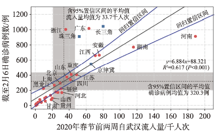
This paper explored the characteristics of intercity human mobility and the 'negative effects' of massive intercity population movement in China by using mobile internet positioning big data. Two travel periods of Baidu Migration data were selected involving Spring Festival and usual travel time. Based on two mobility indicators, i.e., movement scale and movement scope, the spatial characteristics of intercity population movement were measured by local spatial autocorrelation. With a vital public health emergency, linear regression models were used to measure the differences in the negative effects of the national intercity population movement on different cities and urban agglomerations in China. It is found that three major urban agglomerations, namely, the Yangtze River Delta, the Pearl River Delta, and Beijing-Tianjin-Hebei, are the most significant high-value clustering area of mobility in China. Urban agglomerations and megacities are accompanied by higher risks of negative effects for their super mobility. First, the megacity-centered urban agglomeration will have a more significant negative consequence when it is affected by the negative effects of intercity mobility. Second, the megacity-centered urban agglomeration will significantly spread the negative effects through intercity mobility. It is proposed that the security of urban agglomeration should firstly guarantee the security of mobility. The security of urban agglomerations should be reflected in the resilience of intercity mobility networks. In the process of new urbanization, the development strategy of urban agglomerations needs to focus on the mobility and security of urban agglomerations from the perspective of territory spatial security.
Propagation simulation is an important way to recognize the resilience of network structure from a dynamic perspective. Exploring the relationship between the difference in network structure and the state of network propagation is of great significance to the improvement of network structure resilience and the optimization of territory development space. This paper constructs four typical urban network models: nearest neighbor network, small world network, scale-free network and random network. Using complex network theory and SIS virus propagation model, MATLAB and Gephi are used to simulate infectious diseases, and the four types of networks are analyzed. The variation characteristics of infection quantity and infection time under the difference of network shape, node scale and degree value, and the influence mechanism are discussed. The results showed that: (1) From the perspective of overall characteristics, the difference in network structure affects the strength of network propagation. The heterogeneity value distribution, highly local clustering, and short path length of irregular network will expand the scale of infection and shorten the time of infection. (2) From the perspective of decomposition characteristics, scale is not the core factor affecting network communication. High degree of urban network with power law distribution is the risk of regional and urban suppression of negative transmission. (3) From the perspective of spatio-temporal characteristics, heterogeneous network and regular network have the dual characteristics of robustness and fragility. The advantages of heterogeneous network in peacetime and the advantages of regular network in epidemic time should be fully developed through network switching. Based on this, the resilience optimization strategy of land development space network structure is proposed from the regional and urban levels.

The South China Sea (SCS) is the largest marginal seas in China, and also the area with the most problems in marine territories governance. Due to the fluidity of the sea and the fuzziness of the boundary, marine territory control have many characteristics different from that of the land. Marine territory governance mainly includes islands, sea areas, resource exploration and fisheries management. The territorial control of the SCS is particularly complex and sensitive due to the sovereignty and territorial disputes between China and its neighbors. Firstly, this paper teases out the relevant concepts of maritime territory and summarizes the connotation of maritime territory regulation. Based on the above, this paper discusses the issues related to territorial control and governance of the SCS, and then divides them into two groups, one is resource-ecological dimension, and the other is humanistic-institutional dimension, and the research progress of related issues is discussed in combination with the current dynamics of marine territory governance in the SCS. This paper believes that the future studies of marine territory governance in this water should mainly focus on three aspects, namely, regional development in the SCS, sea relations in the SCS, and the multi-scalar territorial governance in the SCS. This paper will play a positive role in clarifying the research topics of China's marine territory governance and management, and further improving China's marine territory optimization mechanism.
A better understanding of the connotation of "territory" is a prerequisite for developing the theoretical system and advancing the practical work of spatial planning. It is necessary to constantly update the understanding of "territory" in accordance with the development of disciplines and the changes in the real needs of spatial governance. Therefore, this journal invited 15 young scholars to discuss the connotation of "territory". The main points of view are as follows: (1) Territory is a complex coupled human and natural systems, with the characteristics of pluralism on elements and nesting on spatial and temporal scales. It is necessary to use the thinking of "landscape, forest, field, lake and grass" as a life community to carry out the comprehensive development and utilization and systematic restoration and protection of territory, so that it can become a natural governance platform. (2) Territory is a network space constructed by "flow" and a relational space composed of different stakeholders. It is necessary to integrate the territory through the "space of flows" to promote the sharing of resources and elements between regions to achieve coordinated development; it is also necessary to pay attention to the reconstruction of human and natural relationships and interpersonal relationships, coordinate the interests of multiple subjects, and achieve harmonious development. (3) Territory is a human space. It is necessary to fully perceive the risks, suitability, constraints, and accessibility of the territory. We need compile people-oriented spatial planning to enhance the ecological value, aesthetic value and humanistic care of territory. (4) Territory is the object of spatial planning and governance. It is a specific spatial carrier with marine space, rural space and cultural space, etc. It has attributes such as rights and assets. It is necessary to realize the unified management of resources and assets in the spatial planning, and highlight its economic value, social value and ecological value to achieve the diversified needs of high-quality development and high-quality life for territory.
Public security events are the results of the interaction of 'Human-Space-Time' in a specific context. Public security spatial planning and the corresponding administration system are important approaches to deal with the public security events in the long term. Based on the framework of 'Human-Space-Time' interaction in the public security planning, this paper reviews the relevant research about 'prevention, early warning, emergency dispatching, and post-disaster recovery'. On this basis, the framework of content, technical methods and support system of public security spatial planning is constructed. First, the content system should be consistent to the multi-level spatial planning system and the national emergency response mechanism. It is necessary to implement special planning and comprehensive planning, focusing on the problems of the planning and management of space, facilities and emergence response in terms of natural disasters, accident disasters, public health events and social security events. In terms of the technical method system, it is necessary to build and improve the methodological and technical support system of space-time elements identification and analysis, space-time process simulation and early warning of public security events. Last, for the support system, it is necessary to improve the space-time accessibility of the public security facilities system and strengthen the public security oriented social governance, based on the new infrastructure construction such as the space-time big data management system.
At present, China's territory spatial planning attempts from top to bottom to resolve or relieve the key issues from macro level as far as possible which has arisen since the reform and opening-up such as the ecological environment, resources restriction, the conflict of man-land relationship, multiple management and the authority of spatial plans. Although China's territory spatial planning system, organization framework and technical regulation have so far formed relatively reasonable "universality" norms, at the strategic level, the discussion of regional "individuality" issues in the context of national security is still lacking. Facing the needs of the country and the special situation of Western China, we should establish a cross- province and cross-basin territory spatial planning of this region based on national security strategies. To ensure national security, territory spatial planning of Western China at the strategic level should focus on the following: (1) In theory, based on the perspective of national security, we proposed to construct the cross-province and cross-basin territory spatial planning of Western China. (2) In practice, we recommend formulating the "territory spatial planning of Western China-ecological security" of specialized national territory spatial planning which takes ecological zone, nature reserve as the core in spatial scale. What's more, based on the border and support line, we should carry out "territory spatial planning of Western China-survival security" of specialized national territory spatial planning, or determine the detailed rules and regulations of national defense security in spatial planning. In addition, taking the urban system as the organizational context, we should set up "territory spatial planning of Western China-life security" of specialized national territory spatial planning which is relying on main transportation lines, or determine the detailed rules and regulations of the harmonious society construction in Western China. Besides, following the divisions of the Main Functional Areas, we should formulate "territory spatial planning of Western China-production security" of specialized national territory spatial planning which is focusing on the regional central city and urban agglomeration, or determine the high-quality economic development in the western region. We should also restructure the ecological space, survivable space, living space and production space. (3) In particular, we recommended strengthening the construction of border towns or villages, and establishing the "sanxian" (three lines) construction in the New Era, "the key construction belt around the Qinghai-Tibet Plateau" in the western region, which can meet the national security needs of limited globalization and achieve "dual circulation pattern" in the post-epidemic period. On the whole, the territory spatial planning of Western China should be different from that of the eastern and central regions. We should not impose uniformity on the implementation of the policies.
The urban system is faced with more uncertain risks and unknown disturbances in the coming future, which requires that the urban safety and disaster prevention planning should carry out adaptive adjustment in terms of target object, strategic positioning, technical means, planning concept, etc., so as to achieve regional security and stable development through flexible urban design. In this paper, we summarize and comment the theoretical development and practical exploration of resilient city. Combined with the construction of territorial planning system after "multi planning integration" in China, we reconsider the connotation characteristic, process structure, form content and public governance of resilient planning under the background of territorial governance. Then we put forward practice outlook of urban resilience and safety planning from four aspects, including deepening the theoretical construction and mechanism research of resilient city, changing the design thought and practice flow of planning, improving management and control transmission and scale governance in the practice, and focusing on the grassroots governance and public participation in resilience design. All the efforts are contributed to promote the modernization of urban public security governance construction in China.
In the process of rapid industrialization and urbanization, the interference effect of human activities on the structure and function of ecosystem has been increasingly intensified. Land ecological restoration has become an essential topic of ecological civilization construction and land spatial planning. Determining priority areas for ecological restoration based on holistic protection and systematic governance, is a critical method for the scientific and orderly promotion of land ecological restoration. Taking Changsha-Zhuzhou-Xiangtan Urban Agglomeration as an example, we used human footprint to evaluate the intensity of human disturbance to the ecosystem quantitatively. On this basis, through the minimum cumulative resistance model, circuit theory, and cyclic window search method, the ecological network was identified, and the key areas where human disturbance caused damage to its structure and function were determined as priority areas for ecological restoration. The research showed that: (1) The human disturbance in the urban agglomeration presented a core-edge decreasing circle distribution, and the west was higher than the east while the north was higher than the south. In the study area, low disturbance area, medium-low disturbance area, medium-high disturbance area, and high disturbance area accounted for 12.66%, 32.31%, 37.70%, and 17.33% of the urban agglomeration land, respectively. (2) The ecological network was identified, which contained 140 ecological source patches and 307 potential ecological corridors between them. The corridors were 3986.02 km long, primarily distributed along with the Xiangjiang River system or located in the low hilly area with good vegetation coverage. (3) The priority areas for ecological restoration were determined, including a total of 867.17 km2 for source restoration, 97.83 km for corridor restoration, and 40 points for pinch point restoration. From the perspective of Point-Line-Polygon, restoration strategies were proposed to eliminate or weaken human disturbance, which would help to provide spatial guidance for formulating and implementing of land ecological restoration in the New Era.
With the transformation brought by the renewal and reform of territorial space planning, the improvement of the value of territorial ecological space, the construction of security pattern and the integrated development of multiple elements are becoming more and more important. The establishment of the national territory development planning system is the great ecological significance, and ecological priority is the core value of the formation of the national territory development planning system. Among them, the ecological restoration planning at the county level is an important part of the current national territory development planning. This study takes the land space of Weiyuan county, Sichuan as the research object, analyzes its serious problems of ecological resources destruction, ecosystem disruption, and low ecological efficiency in the background of industrialization and urbanization. It is pointed out that the construction of ecological security pattern is the goal orientation of national territory ecological restoration planning, and the evaluation index system of coupling degree is constructed by using the coupling method of eco-socioeconomic system. From the three aspects of the restoration of ecological elements, the optimization of ecological structure and the promotion of ecosystem value, combined with the typical ecological engineering technology, the ecological restoration security pattern composed of point, line and area is constructed, and the countermeasures of ecological management and restoration are proposed. The results show that: (1) The ecological restoration planning of counties has the characteristics of multi-level objectives, system complexity and diversity of approaches, and the response planning countermeasures can be put forward from the macro, meso and micro levels. (2) The coupling degree of eco-socioeconomic system in Weiyuan fluctuates between 0.457 and 0.497, and the ecosystem and socioeconomic system are now in an antagonistic period and have a development trend in the running-in period. (3) According to the calculation results of coupling degree, comprehensive efficacy and index influence degree, the overall pattern of ecological restoration of "multi-corridor and multi-point, two veins and two rings, one screen and two areas" can be constructed. The study puts forward the special planning methods and practical application of ecological restoration at the county scale, which can provide new ideas and methods for the current national territory spatial ecological restoration planning system of counties.
The regional and department allocation of land use index is the key problem of National Territory Development Planning System. The most important task in this round of territorial space planning remains the optimal allocation of land use indexes of different types with the full consideration of the development wills of local governments at all levels. The task should be in line with the actual development of China's diverse physical geographic regionalization and economic and social regionalization, in particular, the actual land use in three different regions, namely, urbanization-forming region, urbanization-developing region and urbanization-shrinking region with the implementation of state will and national strategy. In this paper, the authors seek to establish a multi-scale, multi-region and multi-context simulation framework of China's Territorial Spatial Planning Model (CTSPM) based on the Spatial Computable General Equilibrium (SCGE) model, and proposes the actual application contexts in the safety simulation of territorial space for the support of the national territorial spatial framework simulation and analysis of multiple national development contexts and land index allocation planning as well as the analysis of its socio-economic influences and ecological environmental influences. The authors hope that this framework would serve as a "debate" platform for the "game" for obtaining land index between regions and departments and also an analytical framework for a scientific national territorial and spatial planning and a deep understanding of the cross-regional influences of national spatial safety.
The increasing frequency of flood hazards in recent years highlighted the contradiction between urban construction and flood control. It is important to re-examine the core principles and methods of disaster prevention planning that focused on flood prevention infrastructure and sponge city planning for landscape ecological infrastructure. This paper proposes that, in the context of territorial spatial planning, the core principle of rainstorm flood safety pattern should be "policy integration". The integrated policies do not conflict in spatial layout, but lead to the same goal and result. Based on this core principle we proposed a theoretical framework of rainstorm flood control pattern in land space. Under this framework, the identification of stormwater control elements is the prerequisite, and the key approach is to establish an integrated relationship between stormwater safety elements and land use spatial structure, resource use, and infrastructure systems through controlling measures and guiding measures. This study aims at realizing the safety goals and forming spatial patterns on different spatial scales. To better interpret the theoretical framework, this paper takes the Zhenguan town, Wanzai county, Jiangxi province as a case study to explore and test the operationality and application value of the theoretical framework in practice. This research provides a new perspective and theoretical basis to achieve flood safety pattern.
Urban function, agricultural function, and ecological function make up the entire territorial spatial function system. Scientifically grasping the quality of regional territorial spatial functions and deeply revealing their coupling coordinated relationships is an important basis for achieving sustainable development of territorial space. In order to explore the development status of territorial spatial functions in karst areas of Southwest China and their characteristics of spatial structures, Guangnan, a typical karst county, was taken as a study area. Based on the construction of urban, agricultural, and ecological function evaluation index systems, the paper evaluated the function quality and its spatial characteristics with the help of comprehensive evaluation method and exploratory spatial data analysis method, used coupling coordinated degree model to examine the coupling coordinated status of territorial spatial functions, and further explored the territorial space development of coordinated development of urban-agricultural-ecological functions. The results showed that: (1) The urban function quality and agricultural function quality showed mainly low values, and the ecological function quality had mainly high values. The low and high values of comprehensive function quality tended to be evenly distributed. And the spatial distribution of different functional qualities was different. (2) The development of all the four territorial spatial function qualities had a positive correlation, which was mainly "high-high" and "low-low" agglomerations, and there were differences in geographical distribution. (3) Territorial spatial functions in karst areas had a great influence on each other, and the distribution of low- and high-coupling areas was significantly different. Of all the functions, the coupling degree was the lowest in the fuction of construction land. (4) The coupling coordinated relationship of territorial space functions could be divided into four levels from imbalance to coordination, and the differences in their spatial distribution were similar to the differences in the territorial spatial comprehensive function quality. The countermeasures of territorial space coupling coordination areas could effectively promote the sustainable development of territorial space for karst areas, and improve the territorial space function quality in karst areas. The results of this research provide references for territorial spatial balanced development and optimized regulation in karst areas of Southwest China.
The frequent occurrence of natural and man-made disasters in the process of urbanization has seriously restricted the survival and safe development of cities. We used Chuzhou central city, one of the representative disaster prone areas, as a case study to measure safety risk. We constructed a safety risk index system, based on a typical Pressure-State-Response (PSR) conceptual framework. We then used coupling indication model to compound the risk assessment results of each single disaster, and quantitatively evaluated the distribution characteristic of urban safety risk. Finally, we used geographic detector to analyse the impact mechanism of the driving indicators of urban safety risk. We found that: (1) The proportions of urban safety risk grades from low to high were 2.49%, 8.71%, 41.08%, 30.47% and 17.25%, respectively, with medium risk dominating the study area. Spatially, the safety risk of central area was higher than that of the surrounding areas, that is to say, it showed a declining trend from the central city to the suburbs. (2) The order of the explanatory power intensity of the driving indicators on the safety risk was as follows: population density (0.404) > GDP density (0.402) > building disaster tolerance (0.095) > vegetation coverage (0.078) > road network density (0.013) > risk of land use type (0.012), and the explanatory power of the results was enhanced by interaction of factors. The research will provide a new theoretical perspective and framework for urban safety risk assessment, and help for disaster risk management in high risk areas.
China is experiencing the fastest urbanization process in the urban development history of the world. However, several urban issues, such as environmental pollution, extensive and disorderly development, and insufficient governance, have risen to hinder the sustainable development of Chinese cities. As a new type of urban governance mode that implements the requirements of the Central Urban Work Conference, urban physical examination has been prioritized on the working agenda of local governments, in order to solve striking problems including "urban diseases" and to promote high-quality development. However, scholarly discussions on the methods and implementation strategies of urban physical examination have received little attention. Guangzhou is selected as a pilot city for carrying out nationwide urban physical examinations. It has certain innovations in terms of the selection and optimization of indicator evaluation system, diagnosis of urban issues and exploration of implementation strategies. Taking Guangzhou as an example, on the basis of reviewing territory space security, urban physical examination and related research, a basic framework for urban security assessment research was initially established on urban security dimension. Subsequently, the principles of operability and rationality was adopted to select the indicators, and an innovative technical method for screening and optimization of the index system was proposed. Based on more than 10000 questionnaire surveys collected from government departments and citizens, we combined the top-down transmission control with the bottom-up social demands, and further proposed that policies and regulations, standards and norms, action plans, construction projects could be integrated to promote the urban physical examination. Furthermore, the effectiveness of urban safety improvement was continuously monitored through social satisfaction surveys and physical examination information platforms. This study can provide some references for conducting urban physical examinations throughout the country.
At present, the mode of administration of territorial space is changing from the original "cluster" of space planning to a unified territorial spatial planning. The territorial space security, the bottom line of space development, has become the focus of heated discussions from all walks of life. Based on the system theory, this paper sorts out the territorial space and its planning system, and mainly analyzes what kind of territorial spatial planning can better guarantee the security of territorial space. Studies have shown that: (1) A sound legal system and a scientific system interface for territorial spatial planning are the key to ensuring the security of the territorial spatial planning. (2) The legislation for territorial spatial planning should be established with the law of territorial spatial planning as the basic law, and a clear structure and unified content legal system with laws, regulations and standard systems as the core should be formed to make the territorial spatial planning system structure reasonable. (3) In terms of system interface, we should establish a three-dimensional system with hardware interfaces and software interfaces as the main types and the entire life cycle of territorial spatial planning as the core. The system interface can realize the three-dimensional connection of "five levels, three types and four systems".
To satisfy the needs of territorial spatial planning system construction and response to public health emergencies, it is necessary to reform regulatory detailed planning indicators and management system. On the basis of in-depth analysis of the response and inadequacy of the existing control management to territorial space emergency safety and security, this study proposed the "prevention + emergency" regulatory planning management path and constructed the index implementation system. "Prevention" refers to the shaping of the spatial environment to improve urban resilience and enhance the city's ability to resist the risk of uncertainty. The main methods of "prevention" are: (1) Integrating the concept of healthy city into the index system of regulatory detailed planning. (2) Reducing the management scale of regulatory detailed planning units to form a spatial transmission system from the zone unit to the block unit. "Emergency" is to ensure the sustainability of the city's life system in the event of a public health emergency through control and regulation management, and to meet the need for epidemic prevention by guiding the compatibility of part of the land and the layout of emergency facilities, access and space through control and regulation.
In terms of the county area, widening the concept application of main functional areas and exploring the spatial allocation efficiency of land resources and its control strategies are of great significance to deepening China's territorial space governance system. This paper combs the theoretical relationship between main functional areas and land resources spatial allocation, the spatial allocation efficiency of land resources in main functional areas of Ganyu district, a typical county-level unit in Jiangsu province, was investigated with the C-D production function, and the differentiated control strategy was put forward. The result shows that the essence of main functional areas construction is "based on land", and land resources spatial allocation should follow the transformation degree of equal marginal net income based on the concept of functional zoning, which makes it possible to improve land efficiency and reduce the efficiency loss of spontaneous competitive advantage. A study of Ganyu district found that the excessive allocation of agricultural land to development land in different main functional areas has the pareto improvement space, which is rooted in the inelastic mechanism of the current land planning management to regulate the spatial land use index, resulting in the spatial mismatch in the actual landing. Therefore, the effective allocation of land resources in Ganyu should be based on the overall planning of main functions and the coordination of land space development pattern, including: optimizing development areas should renovate the spatial structure of land and transform the mode of economic and industrial development; key development areas will contribute to the industrialization of cities and towns and ensure the efficiency of land resources use in the region; restricted development areas focus on the safety of grain and economic products and innovate the management mode of agricultural production land; prohibited development areas draw the red line of ecological space in development zones and explore the layout and structure of agricultural and tourism ecological land.
With the development of urbanization, the vulnerability of cities is increasing. In recent years, frequent production accidents highlight the limitations of traditional risk management paradigm. Source prevention and control, multiple actors' participation, and data-driving are important issues in the current production safety risk management. How to link the concept of territorial spatial safety with the demands of industry production safety is an important cornerstone to promote the sustainable development of economy and society. It is necessary to introduce holistic thinking to innovate the management normal form of industry production safety risks. The risk generating ring and territorial spatial ring (double ring conceptual model) under the mutual construction of "three living" spaces are the theoretical basis of risk management from the perspective of multidimensional safety and spatio-temporal distribution. The model points out the overall idea of focusing on the source of risk and expanding the perspective, means and main body of risk prevention and control. It aims at mining the positive role of information technology in territorial dynamic monitoring and risk cognition accumulation, and then building a "flat" risk monitoring and evaluation framework to explore the needs and functions of the "brain" - information platform. Taking the chemical industry as an example, this paper focuses on the multiple actors' prevention and control paradigm and proposes a basic framework of production safety risk under the leadership of industrial parks, so as to provide reference for the formulation of risk prevention and control schemes for different industries.