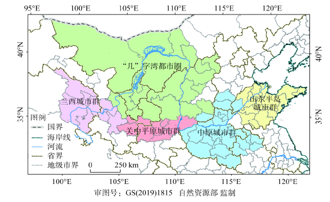
Ecological protection and high-quality development of the Yellow River Basin is one of the major national strategies, in which urban agglomeration and industrial transformation development are the intrinsic requirements and fundamental guarantees. Thus, revealing the path of the river basin scale urban agglomeration development and industrial transformation and upgrading is of great significance to guide the high-quality development of the Yellow River Basin. Therefore, this paper brings together scholars from the Institute of Geographic Sciences and Natural Resources Research, Chinese Academy of Sciences, Research Institute for Eco-civilization, Chinese Academy of Social Sciences, Yellow River Institute of Hydraulic Research, Capital University of Economics and Business, Peking University and Henan University, to discuss key issues on urban agglomeration and industrial transformation development in the Yellow River Basin from the perspectives of ecological protection, resource allocation, dynamic evolution, spatial structure, and integration and regulation. This paper aims to serve the major national stragety of ecological protection and high-quality development of the Yellow River Basin. The core views are as follows, regulating the relationship among water resources, urban agglomeration and industrial development is the key to promoting the coordination of industrial transformation and urban transformation, and the synchronized advances of economic transformation and social transformation;the analysis of the complex coupling and dynamic evolution mechanism of river basin ecological protection and high-quality development is of great significance for achieving high-quality development of the basin; it is an effective way to promote the high-quality development of the basin to reveal the evolution mechanism of typical urban agglomeration and industrial space and to construct the spatial integration target and mode of urban agglomeration and industrial transformation development; under the background of increasing uncertainty of trade caused by globalization and energy revolution, complex relationship between social economy and ecological environment, and the construction of a new development pattern of "dual circulation", the basin urgently needs a more comprehensive integrated regulation mechanism.
Master Plan for Major Projects of National Important Ecosystem Protection and Restoration (2021-2035) (hereinafter referred to as The Plan) is the first comprehensive plan involving ecosystem protection and restoration after the 19th National Congress of the CPC (2017), which plays a significant strategic and guiding role in undertaking related tasks. The promulgation of The Plan, accomplished by the Chinese government departments concerned, is a successful beginning for jointly arranging major projects in natural resources across departments, disciplines and regions. Recently, some critical contents relating to The Plan, such as the opportunities and challenges of implementation, were discussed by seven experts from Consulting and Research Center of the Ministry of Natural Resources. The key opinions are as follows. In order to work efficiently guided by The Plan, its four main characteristics need to be especially concerned, including systematic and continued deployment; strategic and coordinating policies; objectives-problems dual oriented tasks; and scientific and specific methods. Meanwhile, it is necessary to deal with three kinds of crucial relationships about aims and assignments properly, which are ecosystem protection and utilization, ecosystem restoration and ecological compensation, ecosystem protection and controls on territory use. Besides, seven valued aspects are still worthy to be deeply pondered and some suggestions are proposed, including: establishing diversified financing mechanism, clarifying responsibility of different entities carrying on ecological protection and restoration, formulating related systematic technical standards, strengthening databases and information platforms, optimizing territory use control regulation to adapt to the major projects of The Plan, coordinating ecological protection and natural resources especially energy resources exploitation, reinforcing early basic and comprehensive investigation and later strict surveillance as well. In addition, it is requisite to monitor and evaluate the executive conditions of The Plan and other supporting policies, so as to adjust and improve The Plan in time, which is beneficial to fulfill tasks and achieve goals.
The balance of water and land resources system in pastoral ecotone is the guarantee for the development of regional farming and animal husbandry. Taking Yanchi county of Ningxia as an example, this paper evaluates the carrying capacity of water and land resources based on matter element model and studies the driving factors affecting the change of carrying capacity of water and land resources, analyses the factors affecting the carrying capacity of water and land resources and their regional differences, and explores the optimization path of dual guidance of economy and society as well as resources and ecology. The results show that: (1) The carrying capacity of water and land resources of Yanchi county presented a symmetrical X-shaped pattern at a medium level and had great potential for development. Huamachi and Huianpu had higher carrying capacity, while Mahuangshan, Wanglejing and Dashuikeng had the lower. (2) There were obvious regional differences in the coupling and coordination of water and land resources in rural areas of Yanchi county in 2018, and the whole study area was in the antagonistic coupling stage. The coupling and coordination degree of towns was relatively high, while that of rural areas was relatively low. (3) There is a lack of synchronization between water resources and land resources utilization. Water resources lagging areas should take water resources adaptive management and control measures and "ecological conservation + water conservation" to protect mountains, rivers, forests, farmlands and lakes in a coordinated way. Land resources utilization lagging areas should actively explore the main function-oriented zoning, dominant type classification and principal purpose classification optimal distribution strategy of land resources in farming and animal husbandry space in combination with land engineering control measures and industrial restructuring. The strategy of synchronous optimization of resources use, ecological protection and socio-economic development based on the balance of water and land resources in rural areas of Yanchi county provides research reference for the development of agricultural transformation and the implementation of rural revitalization program in the pastoral ecotone.
With the rise of the Internet and social media, geo-tagged data in the sharing of users has become an important content of tourism flow research. Based on the photos of on the Flickr platform during 2010-2018, this study takes the spatial characteristics of Nanjing inbound tourism flow as the research object, and uses the methods of DBSCAN algorithm, ArcGIS 10.2 and others to explore inbound tourism hotspots area, the features of moving trajectory and patterns of Nanjing. The results of the study show that: (1) The peak of inbound visits occurred in March-June and October, and the tourists mainly took one-day trips. (2) There are obvious differences in the spatial distribution of Area of Interest (AOI) in Nanjing. The historical urban district (HUD) is most popular for inbound tourists, and has the largest number of AOI, followed by the central urban area (CUA), and the suburbs. The distribution of AOI in the HUD is highly coincident with its related industrial space, such as tourist attractions and commercial shopping centers; Zhongshan Scenic Area in the CUA is a hotspot for tourists who are interested in history and culture; the distribution of AOI in the suburbs is basically consistent with that of local tourist attractions. (3) There are great differences in moving trajectories between single-day and multi-day trips, which are reflected in the network scope, network system, tourism inflow and outflow, and transfer difference. (4) The patterns of inbound moving trajectory can be divided into intra-area pattern and inter-area pattern. Based on the above results, suggestions are proposed for development of historical urban area, central urban area and the suburbs.
Through examining the urban ecological consumption and well-being level in the Yangtze River Delta from 2000 to 2017, this study analyzes the temporal and spatial evolution process and the driving model of ecological well-being intensity. The results show that the ecological intensity of well-being in most cities in the study area decreased by varying degrees with most cities having low or medium intensity. An increase in natural capital was required for every percentage point increase in well-being level, and the efficiency of transforming urban ecosystem services into well-being increased to varying degrees. Moreover, the efficiency of social services in generating social well-being was relatively high, so the corresponding amount of necessary natural capital was small. The intensity of environmental well-being first increased and then decreased over the time period. Analysis of spatial evolution shows that the ecological well-being intensity of the peripheral cities was lower than that of the core cities with the range of low intensity types spreading to the central part of the delta within four weeks. However, the medium and high intensity types were mainly distributed in resource-based and industry-intensive areas. In examining the driving factors of well-being, the resource consumption effect, technical effect, and well-being effect significantly increased urban ecological well-being intensity, while the strengthening of efficiency effect and economic effect decreased it. Additionally, the driving forces of the environmental consumption effect and scale effect were not significant. Furthermore, the driving model of urban well-being ecological intensity can be divided into four types: single-factor dominant, two-factor dominant, three-factor synergistic, and four-factor balanced.
Coupling the supply and demand of ecosystem service with the security pattern of landscape ecology, and deconstructing the ecological space structure of urban agglomerations are the basis for optimizing the spatial arrangement of agriculture-urban areas-ecology networks. Based on the theory of supply and demand for ecosystem service, ecosystem service supply area was determined by fusing the most important areas of the integrated ecosystem services and the boundaries of the ecological red line, by taking Xiamen-Zhangzhou-Quanzhou Urban Agglomeration in the southeast coast of Fujian province as an example. In combination of natural and economic factors, the consumption pattern can be constructed. The minimum cumulative resistance model was further applied to establish a landscape ecology security pattern in order to identify landscape components, such as demand zones, network of ecological flows, and key nodes. Furthermore, the ecological network space of Xiamen-Zhangzhou-Quanzhou region was reconstructed by utilizing layered overlay analysis. The results showed that: (1) The supply area occupied 41.64% of the study area, in addition, ecological buffer zones, ecological sensitive zones, and production and living zones accounted for 22.67%, 31.58%, and 4.11%, respectively. (2) The source of supply was mainly distributed in the hilly and mountainous areas of the central and western regions, where the low-cost areas of ecosystem service were located. The high-cost areas concentrated in the coastal regions were characterized by an octothorpe shaped distribution pattern. (3) Ecological flow paths were highly meshed. They were mainly composed of forests in the central and western regions, and urban water system, green space systems and surrounding farmland in the eastern coastal areas. Both the type and intensity of the driving factors suggested significant spatial heterogeneity. (4) Constructing an ecological network space optimization layout of "nine zones, four groups, one belt, nine corridors and multi-centers" in the study region was also proposed in this research, so as to coordinate the production-living-ecological function among the region and facilitate the synergetic development of the economic-ecological space.
The shortage and uneven distribution of water resources in China are very serious. The contradiction of water utilization has changed from insufficient supply to overload of Water Resources Carrying Capacity (WRCC). Based on the concept of sustainability, this study, combined with the society cycle process of virtual water, improves the evaluation method of WRCC and analyzes the WRCC of Northwest China. The method can be helpful to maintain the integrity of water ecology and the stability of water supply. The results show that: (1) The WRCC of Shaanxi is generally good. However, it has a downward trend in the past ten years, in which the environmental pressure is the largest. The WRCC of Gansu shows a downward trend on the whole, especially in terms of environmental and social pressure. The WRCC of Ningxia has been on the verge of overloading or slight overloading, and alleviated by virtual water trade. The WRCC of Xinjiang is greatly affected by virtual water outflow and has been on the verge of overloading or slight overloading. The WRCC of Qinghai is basically in a surplus state of carrying capacity. (2) Virtual water trade has a significant influence on the comprehensive pressure index of WRCC. The evaluation method of WRCC, combined with the society cycle process of virtual water, has a practical significance. (3) The regions of different endowments of water resources and the efficiency of using water can be appropriately different in development modes. We suggest that the regions with high and low use efficiency of water take the "radical development mode" and the "radical environmental protection mode", respectively.
In order to realize the optimal allocation of regional water resources and the coordinated and sustainable development of regional economy, society and water resources, and to ascertain the physical quantity of regional water resources, this paper chose the southern part of the Lyuliang Mountainous Contiguous Poverty-stricken Area, where the water resources ecology is extremely fragile, as a case study. Based on the actual water resources data from 2008 to 2017, we compiled the regional water resources physical quantity and analyzed the spatial and temporal distribution characteristics of water resources. The results show that: (1) The physical quantity of water resources in the study area showed a significant increasing trend during the study period, with the growth value (including their duplicate) as high as 6101×104 m3. During the study period, the physical stock of surface water increased fast, while the physical stock of groundwater increased slowly. The water consumption in the primary industry increased significantly, which was caused by large-scale promotion of high-water-consumption fruit trees in the region; (2) Residents' water consumption increased significantly, and the per capita water consumption increased rapidly. Residents' water consumption is the main factor affecting the physical stock of local water resources. (3) A larger difference in spatial distribution of water resources can be observed in the study area. The average stock of water resources between counties differs by a maximum of 3971.4 m3; the average water resources per unit area and the actual use of water resources per unit area are the highest in Xixian county, but the lowest in Jixian county. The per capita living water consumption is the highest in Xixian county, while the per capita living water consumption is the least in Fenxi county. (4) There is a high correlation between actual water consumption and total water resources, and the stock of water resources restricts the actual use of water resources to a certain extent. The results of this study have important scientific guiding significance for the optimal allocation of regional water resources and the realization of poverty alleviation in contiguous poverty-stricken areas of the Lyuliang Mountains.
In recent years, due to the dual impact of climate change and human activities, ecosystems have been suffering increasing pressure. To a certain extent, this pressure has changed the structure and process of ecosystems, reduced ecosystem services, and threatened regional sustainable development. Land ecological restoration is a major measure to promote the construction of ecological civilization and an important means to deal with the above ecosystem problems. China has taken it as one of national strategies. However, there have been relatively few systematic reviews and summaries in the current research on the ecological restoration of land and space, which is not conducive to the in-depth development of ecological restoration. Therefore, this article systematically sorts out the evolutionary context of China's ecological restoration work, expounds the differences in the goals, methods, and regions of land and space ecological restoration in different periods, analyzes the current problems encountered in China's land ecological restoration work, and further proposes related countermeasures, which are expected to benefit China's ecological restoration work in the new era. The research shows that: (1) China's ecological restoration research has experienced an evolutionary process of budding, early practice and the new era periods. The ecological restoration goals, methods and regions differed significantly in each period. (2) At present, the main problems of China's territorial and spatial ecological restoration are that there are many historical debts in ecological aspects, many practical contradictions, problems of ecosystem functions are more prominent, the responsibilities of ecological restoration departments are relatively scattered, and the performance of duties is relatively contradictory and single. (3) In the future, targeted land ecological restoration work should be carried out based on the differences in the time dimension, space dimension, administration and market dimension of ecological problems.
The calculation of agricultural carbon emissions and the evaluation of low carbonization levels are important bases for realizing green development of agriculture and formulating carbon emission reduction plans. This article firstly calculated the agricultural carbon emissions of 30 provincial-level regions in China from 2006 to 2016. Based on the calculation results, the agricultural carbon emission derivative indicators were constructed from three aspects: agricultural land, livestock farming and agricultural energy. The low carbonization levels of agriculture in the 30 regions were evaluated by the TOPSIS method with dynamic natural weights. The results showed that China's total agricultural carbon emissions showed a V-shaped tendency, which was 910.96 million tons in 2006 and dropped to 835.21 million tons in 2008, and steadily increased to 921.92 million tons in 2016 afterwards. Agricultural non-energy carbon emissions accounted for more than 84% of the total agricultural carbon emissions, and soil management was the largest source of agricultural non-energy carbon emissions. China's inter-provincial agricultural carbon emission derivatives were heterogeneous, and the overall low carbonization level of agriculture was not high. These provided references for agricultural and environmental departments to carry out low-carbon agriculture evaluation.
Hebei is the most polluted province in China. It is significant to study the spatio-temporal variation of air pollution and its influencing factors. Based on the daily air quality index (AQI), meteorological data and socio-economic data, the spatial and temporal variation characteristics of air quality index and its relationship with influencing factors in Hebei province were examined by statistical analysis and spatial interpolation. The results show that air pollution mainly occurs in the central and southern parts of the province, especially in Handan, Xingtai and Shijiazhuang, but rarely in the north. The air quality index of the province shows a decreasing trend year by year, with a linear trend of -8.845/year, and it has a good negative correlation with wind speed, temperature, precipitation, gross domestic product (GDP), population, electricity consumption and secondary industry, while it has a positive correlation with sulfur dioxide emissions and nitrogen oxide emissions. Adverse climatic conditions are the inducement of atmospheric pollution, and high emission intensity is the main cause of heavy atmospheric pollution. With the rapid economic development and the increase of money invested in full control of air pollution in Hebei, its economy and pollution are on the right side of the EKC curve of environmental Kuznets. The relationship between air quality and economic development in Hebei has passed the "inflection point" of the environmental Kuznets curve. These results can provide theoretical basis for air pollution control in this province.
Urban green space is an important part of urban ecological system. Compared with other types of cities, the ecological and environmental problems of industrial cities are prominent. Therefore, more attention should be paid to the network layout and construction of protective green space. From 2000 to 2017, a large amount of high-quality green space in Baotou, an industrial city, was occupied by urban construction. Urban green space was increasingly fragmented with the reduction of patchy and banded green space. A green space ecological network has not yet been formed. With further development of industrialization and urbanization, the current green space bears greater pressure on ecological protection and restoration than ever before. According to the demand characteristics of protective green space construction in Baotou, this paper evaluated the suitability of green space layout in the industrial city based on the isolation and protection concept, resilient theory and GIS spatial analysis technology. On this basis, priority zoning was performed for the green space layout and construction in combination with the spatial distribution characteristics of current green space. The results showed that : (1) The suitable green space layout of the research area was 449.59 km2, accounting for 71.41% of the total area of the research area (629.59 km2), which can increase the coverage rate by 26.7% compared with the current green space coverage rate (44.71%). (2) There were large undistributed green space and large area of low-quality green space in the suitable area. About 25.73% of the suitable area was not distributed with green space, and the NDVI value of about 47.64% of the suitable area was between 0 and 0.2. (3) According to the results of green space layout and construction zoning, the area of 41.02 km2 can be given priority to green space construction. The results can provide theoretical and practical reference for the layout and construction of protective green space in Baotou and other similar cities.
China is in the important period of New-type Urbanization and ecological civilization construction, and introducing green infrastructure planning framework is of great significance in urban development and ecological protection. Based on "pattern-process-services-sustainability" landscape ecology paradigm, this study reviewed Chinese and international research on green infrastructure (GI) in the landscape scale in recent years. Results show that, in terms of the research on GI pattern, landscape pattern metric method is still the most common one. For landscape connectivity, the structural connectivity method such as Morphological Spatial Pattern Analysis has advantages of calculating simplification and high applicability, but it lacks clear ecological meanings. However, the functional connectivity method including graph theory serves specific ecological process, which will be research core in the future. Research on GI process focuses on biological migration based on the theory and method of ecological network, and its planning process can be divided into 3 parts: selection of core areas, construction of resistance surface and identification of potential corridors. In terms of research on GI ecosystem services, biophysical model and economic value model are widely used in the evaluation of regulating, provisioning and supporting services, and cultural services evaluation takes human feeling derived from questionnaire surveys as the basic data. Additionally, research on demand for ecosystem services involves real consumption and preference of ecosystem services, and its quantitative evaluation and planning application should be further explored. In terms of research on GI landscape sustainability, based on identification of the total amount of ecosystem services provided by GI, trade-offs and synergies between ecosystem services have been taken into consideration in GI planning, and scenario planning can simulate dynamics of GI ecosystem services. Finally, landscape sustainability should be set as the ultimate objective of GI planning, and then 4 research prospects were put forward, including: paying attention to basic research on interaction of pattern and process, deepening research on demand of GI ecosystem services, identifying trade-offs and synergies between ecosystem services and connecting GI with practical planning.
The study of community residents' contribution willingness is an important starting point for wetland conservation. Taking Daqing wetland community as an example, firstly, we design four types of contribution willingness: money-only, labor-only, both-money-and-labor, and neither-money-nor-labor. Then, we investigate and analyze the residents' present contribution willingness in the community by questionnaire. Finally, by using MNL model, we examine the tendential and marginal influences of the willingness types chosen according to the residents' characteristics. The results show that: firstly, 79.8% of the community residents have the contribution willingness, and the willingness of labor contribution is higher than that of money contribution. Secondly, the key factors affecting community residents' preference to contribution willingness are age, monthly income, education level, joining environmental protection organizations and receiving environmental education. Thirdly, the contribution willingness can be significantly enhanced by improving education level and monthly income of the community residents, allowing them to join the relevant organizations as well as disseminate knowledge of environmental protection. We regard labor as distinct presentation of contribution value, and contribution willingness is no longer limited to money. It is suggested that administrators should attach importance to environmental popularization and the operation of environmental protection organizations for wetland communities, and to the role of labor forms in environmental protection contribution.
This article takes Inner Mongolia Autonomous Region as the research area. The Ts-NDVI space is created by using MODIS 16d synthetic vegetation index product data MOD13A2 and 8d synthetic surface temperature product data MOD11A2. Additionally, based on the temperature vegetation dryness index (TVDI) in Inner Mongolia during 2000-2017 growing season, the spatiotemporal characteristics of drought in the study area are analyzed, and the influencing factors of drought are discussed by using air temperature and precipitation data. The results show that: (1) The average TVDI of Inner Mongolia was 0.6 in the growing season from 2000 to 2017, and the area of heavy and moderate drought was the largest, during which 2007 and 2010 are the years with the most severe drought. The spatial differentiation of drought was obvious. The moderate and slight drought mainly occurred in the central and southwest parts, respectively, and severe drought was observed in the Hulun Buir grassland to the west of Da Higgan Mountains. (2) In the past 18 years, the drought degree in Inner Mongolia showed a slight increase trend, and the interannual variation θslope ranged from -0.07 to 0.7. (3) In the growing season of 2017, drought was most serious in June and September, and drought occurred frequently and severely in the Hulun Buir grassland and western Ordos Plateau. (4) TVDI is positively correlated with the average temperature, negatively correlated with the cumulative precipitation and slightly negatively correlated with the slope, positively correlated with the elevation of less than 1300 m, and negatively correlated with the elevation of greater than 1300 m. The analysis of partial correlation between TVDI and climatic factors in Inner Mongolia growing season shows that the drought in northern Sonid Left Banner of Xilin Gol League, Oroqen Autonomous Banner and Hulun Buir grassland has a significant positive correlation with temperature (P<0.01), and that in northeastern Xilin Gol League has a significant negative correlation with precipitation (P<0.01); among the climatic factors, the average temperature has a stronger impact on drought than cumulative precipitation does.
Annual crop climate types refer to different combinations of agrometeorological elements in agricultural year or the whole growth stage of crops, which affects the agricultural planting system, variety distribution, crop development and yield. It is of great significance to know and grasp annual crop climate types and crop potential yield under the background of the effects of climate change on the sustainable agricultural development. Based on the daily meteorological data from 316 meteorological stations and corresponding historical production data of single cropping rice in Southwest China from 1961 to 2015, and by calculating the abnormality of mean temperature, precipitation and sunshine, ten annual crop climate types were determined and the climatic potential yield of single cropping rice under different annual climate types was analyzed, and the impacts of climate change on annual climate types and climatic potential yield of single-cropping rice were also studied. The following conclusions can be drawn as follows: (1) The normal year showed the greatest frequencies with an average value of 21.5, followed by the drought year and rainy year. In terms of spatial distribution, most of the normal years were mainly found in the southern and northwestern Yunnan, Panxi and southern basin of Sichuan. Most of drought years and rainy years occurred in most of the Sichuan Basin and parts of other provincial-level regions. The high temperature year mostly appeared in the Panxi area of Sichuan, a small part of Yunnan and Guizhou. The low temperature year and scant lighting year showed least variations among different regions. (2) The average climatic potential yield of single cropping rice in Southwest China was 7065.6 kg·hm-2 during 1961-2015. Compared with the normal year, the climatic potential yield of single cropping rice in rainy year increased by more than 10%, while that in drought year reduced by more than 14%. Precipitation was the most important limiting factor for climatic potential yield of single cropping rice in Southwest China. (3) Climate warming had the most significant impact on the change of annual climate types in single cropping rice growing season in Southwest China. Compared with 1961-1990, the warm years showed an increasing trend while a decreasing trend was found in the cold years during 1991-2015. In the 55 years, the climatic potential yield of single cropping rice in all the provincial-level regions of Southwest China showed a decreasing trend. Since the 1990s, the increase in warm years was conducive to the improvement of climatic potential yield, and the increase in drought and scant lighting years was the main reason for the decline in climatic potential yield of single cropping rice over Southwest China.
The urbanization process in Eastern China has been accelerating in recent years, leading to underlying surface changes affecting soil moisture in the region. Knowledge of soil moisture is critical to understanding many of the hydrological processes that are of interest in soil hydrology, meteorology, and ecology research. Long-term time series of in situ soil moisture measurements themselves can reveal trends in the water cycle related to climate or land cover change. In this study, we used rainfall and soil moisture data collected at waxberry forests, bamboo forests, farmland, and slope cropland sites in the Hualong River region of Eastern China in 2015 to 2018 to analyse the response of soil moisture to rainfall event size at different soil depths. The results showed the following: (1) In general, the soil moisture content of waxberry forests was slightly higher than that of farmland, slope cropland, and bamboo forests. In the vertical section, the soil moisture in the surface layer (10-20 cm) changed greatly while the soil moisture in the deep layer (60-80 cm) changed little. Meanwhile, the temporal variation of surface soil moisture was larger than that of deep soil moisture. (2) Under different rainfall intensities, the soil moisture of bamboo forests responded more substantially to rainfall than did waxberry forests, farmland, and slope cropland. The greater the rainfall intensity, the greater the response degree of soil moisture. The soil moisture was in a fluctuant downward trend after the rainfall stopped. (3) Quantification of soil moisture by increasing coefficient and reducing coefficient demonstrated that the bamboo forest had the most obvious regression. The other three types of land use varied equally. The soil moisture of waxberry forests, farmland, and bamboo forests changed more dramatically at the surface layer than at the deeper depths. In addition, the soil moisture in the deep layer of slope cropland was affected by the infiltration of surface soil water in the process of regression; this change was complicated, which needs further studies. These research results provide a theoretical basis for the quantitative description of the soil hydrological conversion process, the mechanism of runoff and stream flow, agricultural production, and water resources allocation in the monsoonal Eastern China.
Lakes are sensitive indicators of climate change, and studying their dynamics is important for revealing global climate change. This study selected the Hala Lake Basin in the northeastern Qinhai-Tibet Plateau as a study area, and examined the relationships between the temporal and spatial changes of lake in the Northeastern Qinghai-Tibet Plateau and the climate change based on remote sensing imagery, climatological data, and topographic data from 1986 to 2015. Results showed that the lake area change presented a "V"-shaped pattern in the Hala Lake Basin during the study period. The dynamic change process can be divided into two stages: The stage of volatility decline (1986-2001) and the stage of volatility rise (2001-2015). The lake area decreased from 593.68 km2 in 1986 to 584.83 km2 in 2015 (with a reduction of 8.85 km2) and increased from 584.83 km2 in 2001 to 614.31 km2 in 2015 (with an increase of 29.48 km2). Correlation analysis between changes in lake and glacial areas and climatic factors in the same period of remote sensing data shows that the change of lake area is positively correlated with the stage precipitation, and the relevant significance level is above 0.01. The dominant factor of the dynamic change of lake is precipitation.
Operation projects are the bases of agricultural industry development. What's more, they are important contents of adjusting agricultural industrial structure and improving agricultural comprehensive production capacity under the background of collaborative development in the Beijing-Tianjin-Hebei region. Based on the data of agricultural industrialization management projects in the study area from 2011 to 2016, this paper analyzes the spatial distribution and influencing factors using nuclear density index and other analysis methods. The results showed that: (1) The spatial distribution of operation projects formed an "oblique line" structure nuclear density, which declined from the central part to northeast and southwest. (2) Planting base projects were mainly distributed in southwest Hebei province and east Tianjin maunicipality, and breeding base projects were mainly in south Hebei and central Tianjin. Storage and fresh preservation projects as well as reconstruction and expansion processing projects were respectively transferred to the central north and northeast of the Beijing-Tianjin-Hebei region. (3) The distribution of operation projects were influenced by the total power of agricultural machinery and loan balance of financial institutions, which directly affected the "hardware" conditions of agricultural development and the supply of supporting funds.
The exploitation of mineral resources polluted the environment and destroyed the ecosystem seriously, and it affected the economic growth and residents' life in mining areas. In order to eliminate this negative externality, we must make compensation accordingly. Based on the definition of the concept, this paper systematically combed the theoretical literature of ecological compensation for mineral resources exploitation, and summarized the practice at home and abroad. The research found that there were still some shortcomings in the existing literature, including the design of ecological compensation contract, the allocation of compensation funds, the differential standard of compensation, the transaction cost measurement and critical point of different compensation modes, and so on. These academic issues are worthy of further study in the future. China's ecological compensation for mineral resources exploitation started late, and some problems have emerged in practice, including insufficient system construction and regulatory system, and so on. By contrast, the United States, Germany, the United Kingdom and other countries had rich experience in many aspects, including construction of legal system, classification compensation for different mining areas, entry and exit mechanism, fund guarantee system, construction of regulatory mechanism and so on. Learning from the advanced experience of other countries, we can improve China's ecological compensation mechanism of mineral resources exploitation in some aspects, including improving the legal system, the deposit system and the ecological compensation tax system, as well as establishing and perfecting the regulatory system, and so on.